
Mary K V Hodges (Former Employee)
Science and Products
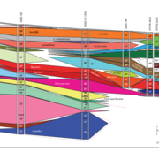
INLPO Geological Framework
A robust geological framework of the eastern Snake River Plain (ESRP) is essential for understanding the hydraulic and geologic properties of the ESRP aquifer, a vital source of drinking and irrigation water in southeastern Idaho. The development of an ESRP geologic framework model at the Idaho National Laboratory Project Office (INLPO) is informed by multiple datasets, including paleomagnetic...
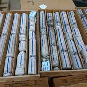
INLPO Core Storage Library
Established in 1990, the INL Lithologic Core Storage Library serves as a centralized facility for the consolidation, cataloging, and permanent storage of nonradioactive drill cores and cuttings from subsurface investigations at and around the Idaho National Laboratory (INL). The library currently houses over 100,000 feet of drill core and cuttings, with new additions made annually. It provides...
Science and Products
INLPO Geological Framework
A robust geological framework of the eastern Snake River Plain (ESRP) is essential for understanding the hydraulic and geologic properties of the ESRP aquifer, a vital source of drinking and irrigation water in southeastern Idaho. The development of an ESRP geologic framework model at the Idaho National Laboratory Project Office (INLPO) is informed by multiple datasets, including paleomagnetic...
INLPO Core Storage Library
Established in 1990, the INL Lithologic Core Storage Library serves as a centralized facility for the consolidation, cataloging, and permanent storage of nonradioactive drill cores and cuttings from subsurface investigations at and around the Idaho National Laboratory (INL). The library currently houses over 100,000 feet of drill core and cuttings, with new additions made annually. It provides...
*Disclaimer: Listing outside positions with professional scientific organizations on this Staff Profile are for informational purposes only and do not constitute an endorsement of those professional scientific organizations or their activities by the USGS, Department of the Interior, or U.S. Government