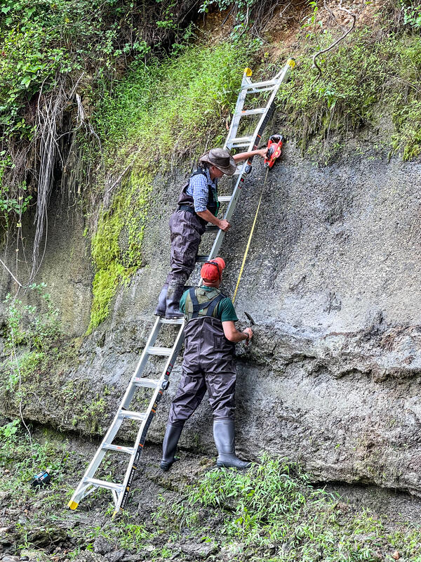
USGS Geologists Jean Self-Trail and Mercer Parker taking field notes, Prince George’s County
Mercer Parker
I am Geologist at the Florence Bascom Geoscience Center where I work under the New England Regional Bedrock Mapping Task as a geologic mapper and carbonate petrologist.
May 2014 – Present United States Geological Survey, Florence Bascom Geoscience Center - Geologist
Perform preliminary petrographic analysis of rock and sediment samples.
Compile, organize, and produce digital images/files/data for use in publications.
Assist in organizing and leading field courses for students and professional geologists.
Education and Certifications
A.S. Geology, Northern Virginia Community College, 2014
B.S. Geology and Environmental Science, James Madison University, 2018
MSc. Geoscience, Ohio University, 2023
Abstracts and Presentations
Parker, Mercer, Orndorff, Randall, C., Valley, Peter, M., Walsh, Gregory, J., 2023, A lithostratigraphic, biostratigraphic, and petrographic analysis of the Middle and Upper Ordovician strata in the southern Champlain Valley, New York, and a preliminary 1:24,000 scale geologic map of the Port Henry quadrangle, Geological Society of America Abstracts and Programs, v. 55, no. 2, doi:10.1130/abs/2023
Science and Products
Appalachian Basin Geologic Mapping Project
USGS Geologists Jean Self-Trail and Mercer Parker taking field notes, Prince George’s County

Geologists measuring and sampling the Paleocene Aquia Formation, Prince George’s County, Maryland
Geologists measuring and sampling the Paleocene Aquia Formation, Prince George’s County, MarylandUSGS geologists Jean Self-Trail and Mercer Parker measuring and sampling the Paleocene Aquia Formation, Prince George’s County, Maryland
Preliminary bedrock geologic map of the Port Henry quadrangle, Essex County, New York, and Addison County, Vermont Preliminary bedrock geologic map of the Port Henry quadrangle, Essex County, New York, and Addison County, Vermont
Designation of a composite-stratotype section for the lower Paleocene (Danian) Brightseat Formation in Prince George’s County, Maryland, U.S.A. Designation of a composite-stratotype section for the lower Paleocene (Danian) Brightseat Formation in Prince George’s County, Maryland, U.S.A.
Hydrogeology, karst, and groundwater availability of Monroe County, West Virginia Hydrogeology, karst, and groundwater availability of Monroe County, West Virginia
Geology and biostratigraphy of the Upper Floridan aquifer in the greater Savannah region, Georgia and South Carolina Geology and biostratigraphy of the Upper Floridan aquifer in the greater Savannah region, Georgia and South Carolina
Chesapeake Bay impact structure—Development of "brim" sedimentation in a multilayered marine target Chesapeake Bay impact structure—Development of "brim" sedimentation in a multilayered marine target
A brief geological history of Cockspur Island at Fort Pulaski National Monument, Chatham County, Georgia A brief geological history of Cockspur Island at Fort Pulaski National Monument, Chatham County, Georgia
Non-USGS Publications**
**Disclaimer: The views expressed in Non-USGS publications are those of the author and do not represent the views of the USGS, Department of the Interior, or the U.S. Government.
Science and Products
Appalachian Basin Geologic Mapping Project
USGS Geologists Jean Self-Trail and Mercer Parker taking field notes, Prince George’s County
USGS Geologists Jean Self-Trail and Mercer Parker taking field notes, Prince George’s County

Geologists measuring and sampling the Paleocene Aquia Formation, Prince George’s County, Maryland
Geologists measuring and sampling the Paleocene Aquia Formation, Prince George’s County, MarylandUSGS geologists Jean Self-Trail and Mercer Parker measuring and sampling the Paleocene Aquia Formation, Prince George’s County, Maryland
Preliminary bedrock geologic map of the Port Henry quadrangle, Essex County, New York, and Addison County, Vermont Preliminary bedrock geologic map of the Port Henry quadrangle, Essex County, New York, and Addison County, Vermont
Designation of a composite-stratotype section for the lower Paleocene (Danian) Brightseat Formation in Prince George’s County, Maryland, U.S.A. Designation of a composite-stratotype section for the lower Paleocene (Danian) Brightseat Formation in Prince George’s County, Maryland, U.S.A.
Hydrogeology, karst, and groundwater availability of Monroe County, West Virginia Hydrogeology, karst, and groundwater availability of Monroe County, West Virginia
Geology and biostratigraphy of the Upper Floridan aquifer in the greater Savannah region, Georgia and South Carolina Geology and biostratigraphy of the Upper Floridan aquifer in the greater Savannah region, Georgia and South Carolina
Chesapeake Bay impact structure—Development of "brim" sedimentation in a multilayered marine target Chesapeake Bay impact structure—Development of "brim" sedimentation in a multilayered marine target
A brief geological history of Cockspur Island at Fort Pulaski National Monument, Chatham County, Georgia A brief geological history of Cockspur Island at Fort Pulaski National Monument, Chatham County, Georgia
Non-USGS Publications**
**Disclaimer: The views expressed in Non-USGS publications are those of the author and do not represent the views of the USGS, Department of the Interior, or the U.S. Government.


