

Better late than never, here's a proper introduction to the USGS Oregon Science Podcast. Learn about who we are, what we do, and what you can expect from us in the future. Plus, as an added bonus, get a teaser for what's coming next month.
Steven Sobieszćzyk
Steven Sobieszćzyk is a scientist and science communicator. While "Sobie" spent most of his career researching landslide hazards, flooding, sediment transport, and stream ecosystems, he now focuses on science communication and promoting scientific literacy. Steve is a multi-hazard responder and has spoken extensively about seismic, wildfire, landslide, flooding, and volcanic hazards.
CURRENT WORK
I'm a public affairs specialist with the USGS Office of Communications and Publishing (OCAP) serving as liaison and media lead for the USGS Natural Hazards Mission Area.
- Public affairs
- Media relations
- Graphic design
- Content creation
Science and Products
When it comes to talking to others, especially when explaining science, the key is consequences outweigh precision. You should always be honest, tell the truth, but don't sweat the small stuff. People care about relatability, not the mundane. Knowing what information isn't worth sharing is hard. There are professionals out there who can help. Like me.
Filter Total Items: 227
Better late than never, here's a proper introduction to the USGS Oregon Science Podcast. Learn about who we are, what we do, and what you can expect from us in the future. Plus, as an added bonus, get a teaser for what's coming next month.
Pharmaceuticals in Urban Streams in Northwest Oregon
Pharmaceuticals in Urban Streams in Northwest OregonCoinciding with the release of the USGS report ‘Reconnaissance of Pharmaceutical Chemicals in Urban Streams of the Tualatin River Basin, Oregon, 2002,’ we sit down and discuss recent findings with USGS hydrologist Stewart Rounds.

TRUE or FALSE: Portland, Oregon, has a volcano within its metropolitan area.
TRUE or FALSE: Portland, Oregon, has a volcano within its metropolitan area.Listen to hear the answer.

Our First Dam Podcast: Dam Removal
We get educated on the whats and whys of dam removal by geomorphologists Jim O'Connor and Jon Major. BONUS: Watch a very cool time lapse video of Oregon's Marmot Dam being breached--click ‘Show Details’ below and scroll to the bottom!
We get educated on the whats and whys of dam removal by geomorphologists Jim O'Connor and Jon Major. BONUS: Watch a very cool time lapse video of Oregon's Marmot Dam being breached--click ‘Show Details’ below and scroll to the bottom!
Flooding and the Pacific Northwest
USGS Hydrologist Tom Herrett gives us the skinny on the flooding in the Pacific Northwest and on how the USGS responds to such events.
USGS Hydrologist Tom Herrett gives us the skinny on the flooding in the Pacific Northwest and on how the USGS responds to such events.
Be Aware of Where during Geography Awareness Week and GIS Day
Be Aware of Where during Geography Awareness Week and GIS DayWe offer you a heaping helping of geography and GIS education and info. Enjoy!
Be Aware of Where during Geography Awareness Week and GIS Day
Be Aware of Where during Geography Awareness Week and GIS DayWe offer you a heaping helping of geography and GIS education and info. Enjoy!
Hazard Roundup--October 2007
A roundup of the previous month's hazard-related events around the world, with some newsworthy tidbits.
A roundup of the previous month's hazard-related events around the world, with some newsworthy tidbits.
Who Do We Think We Are? Find out in This Overview of the USGS
Who Do We Think We Are? Find out in This Overview of the USGSA fearsome foursome of CoreCasters gives you the lowdown on what the USGS is all about, from science responsibilities to products to public events. Warning: This episode of CoreCast is scary informative. Happy Halloween.
Earth Science Week, Continued: Antarctica from Above and Below
Earth Science Week, Continued: Antarctica from Above and BelowIn our second Earth Science Week installment, we talk with scientist Richie Williams about the USGS's amazing new satellite imagery of Antarctica as well as what's going on with ice on the southernmost continent.
April 1982 Kaluapele Eruption
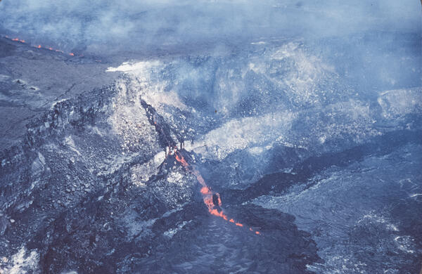
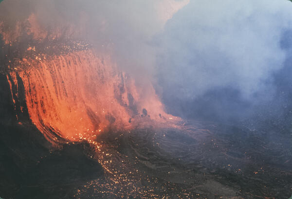
The April 30, 1982, Kaluapele eruption was a short-lived summit event that lasted about 19 hours. Lava erupted from a 3,200-foot-long fissure northeast of Halemaʻumaʻu crater, producing low fountains 15–30 feet high, with bursts up to 160 feet.
The April 30, 1982, Kaluapele eruption was a short-lived summit event that lasted about 19 hours. Lava erupted from a 3,200-foot-long fissure northeast of Halemaʻumaʻu crater, producing low fountains 15–30 feet high, with bursts up to 160 feet.
November 1979 Pauahi Eruption
The November 16, 1979, eruption near Pauahi Crater was a brief, one-day event on the upper East Rift Zone. It was preceded by two months of increased seismic activity, summit inflation, and lava erupting from fissures west of, within, and east of the crater.
The November 16, 1979, eruption near Pauahi Crater was a brief, one-day event on the upper East Rift Zone. It was preceded by two months of increased seismic activity, summit inflation, and lava erupting from fissures west of, within, and east of the crater.
September 1977 Kalalu/Puu Kauka Eruption
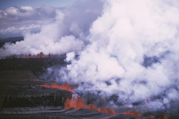
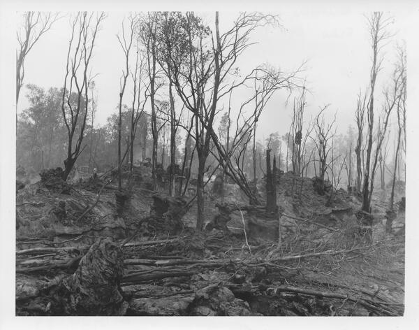
The September 1977 eruption of Kīlauea began after nearly two years of dormancy, with activity breaking out on September 13 along a 3.5-mile-long fissure system between the prehistoric cones of Kalalua and Puʻu Kauka.
The September 1977 eruption of Kīlauea began after nearly two years of dormancy, with activity breaking out on September 13 along a 3.5-mile-long fissure system between the prehistoric cones of Kalalua and Puʻu Kauka.
July 1974 Keanakākoʻi Eruption
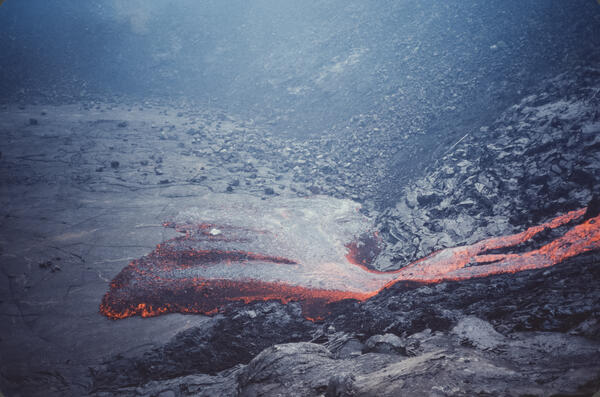
The July 19–22, 1974, Keanakākoʻi eruption was a dramatic summit event triggered by a sudden increase in seismicity and summit deflation. Lava fountains up to 180 feet high erupted from fissures north and south of Keanakākoʻi Crater and on the caldera floor, sending lava flows about 1.5 miles southward and across the caldera floor.
The July 19–22, 1974, Keanakākoʻi eruption was a dramatic summit event triggered by a sudden increase in seismicity and summit deflation. Lava fountains up to 180 feet high erupted from fissures north and south of Keanakākoʻi Crater and on the caldera floor, sending lava flows about 1.5 miles southward and across the caldera floor.
1969 Rift Eruption near Nāpau Crater
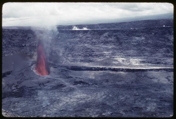
The February 1969 rift eruption near Nāpau Crater was a brief but dynamic precursor to the long-lived Maunaulu eruption that began in May of that year. This week-long event featured lava fountaining from multiple fissures along a 2.5-mile stretch of Kīlauea’s upper East Rift Zone.
The February 1969 rift eruption near Nāpau Crater was a brief but dynamic precursor to the long-lived Maunaulu eruption that began in May of that year. This week-long event featured lava fountaining from multiple fissures along a 2.5-mile stretch of Kīlauea’s upper East Rift Zone.
1961 Fissure Eruption near Nāpau Crater
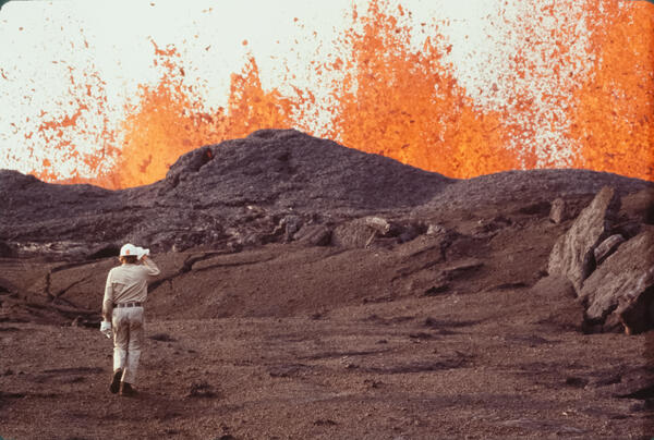
The 1961 fissure eruption near Nāpau Crater was a short-lived but notable event on Kīlauea’s East Rift Zone, occurring in late September. Over two days, lava erupted from vents along a 13-mile stretch, producing 13 small flows and lava fountains that reached heights of up to 400 feet, with the largest flows occurring near Pāhoa.
The 1961 fissure eruption near Nāpau Crater was a short-lived but notable event on Kīlauea’s East Rift Zone, occurring in late September. Over two days, lava erupted from vents along a 13-mile stretch, producing 13 small flows and lava fountains that reached heights of up to 400 feet, with the largest flows occurring near Pāhoa.
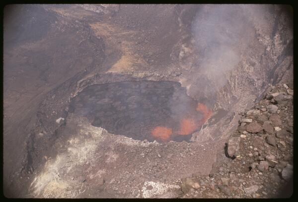
July 1961 Summit Eruption
The July 1961 eruption at Halemaʻumaʻu was the third summit eruption of that year, continuing the pattern of vigorous volcanic activity at Kīlauea. This event featured sustained lava fountaining and further infilling of the crater, building upon the changes initiated by the February and March eruptions.
The July 1961 eruption at Halemaʻumaʻu was the third summit eruption of that year, continuing the pattern of vigorous volcanic activity at Kīlauea. This event featured sustained lava fountaining and further infilling of the crater, building upon the changes initiated by the February and March eruptions.
February 1961 Halemaʻumaʻu Summit Eruption
The February 1961 summit eruption of Kīlauea marked the beginning of a year of intense volcanic activity, characterized by three distinct summit eruptive phases.
The February 1961 summit eruption of Kīlauea marked the beginning of a year of intense volcanic activity, characterized by three distinct summit eruptive phases.
Science and Products
When it comes to talking to others, especially when explaining science, the key is consequences outweigh precision. You should always be honest, tell the truth, but don't sweat the small stuff. People care about relatability, not the mundane. Knowing what information isn't worth sharing is hard. There are professionals out there who can help. Like me.
Filter Total Items: 227
Science is back! And it's better than ever
Better late than never, here's a proper introduction to the USGS Oregon Science Podcast. Learn about who we are, what we do, and what you can expect from us in the future. Plus, as an added bonus, get a teaser for what's coming next month.
Better late than never, here's a proper introduction to the USGS Oregon Science Podcast. Learn about who we are, what we do, and what you can expect from us in the future. Plus, as an added bonus, get a teaser for what's coming next month.
Pharmaceuticals in Urban Streams in Northwest Oregon
Pharmaceuticals in Urban Streams in Northwest OregonCoinciding with the release of the USGS report ‘Reconnaissance of Pharmaceutical Chemicals in Urban Streams of the Tualatin River Basin, Oregon, 2002,’ we sit down and discuss recent findings with USGS hydrologist Stewart Rounds.
TRUE or FALSE: Portland, Oregon, has a volcano within its metropolitan area.
TRUE or FALSE: Portland, Oregon, has a volcano within its metropolitan area.Listen to hear the answer.
Our First Dam Podcast: Dam Removal
We get educated on the whats and whys of dam removal by geomorphologists Jim O'Connor and Jon Major. BONUS: Watch a very cool time lapse video of Oregon's Marmot Dam being breached--click ‘Show Details’ below and scroll to the bottom!
We get educated on the whats and whys of dam removal by geomorphologists Jim O'Connor and Jon Major. BONUS: Watch a very cool time lapse video of Oregon's Marmot Dam being breached--click ‘Show Details’ below and scroll to the bottom!
Flooding and the Pacific Northwest
USGS Hydrologist Tom Herrett gives us the skinny on the flooding in the Pacific Northwest and on how the USGS responds to such events.
USGS Hydrologist Tom Herrett gives us the skinny on the flooding in the Pacific Northwest and on how the USGS responds to such events.
Be Aware of Where during Geography Awareness Week and GIS Day
Be Aware of Where during Geography Awareness Week and GIS DayWe offer you a heaping helping of geography and GIS education and info. Enjoy!
Be Aware of Where during Geography Awareness Week and GIS Day
Be Aware of Where during Geography Awareness Week and GIS DayWe offer you a heaping helping of geography and GIS education and info. Enjoy!
Hazard Roundup--October 2007
A roundup of the previous month's hazard-related events around the world, with some newsworthy tidbits.
A roundup of the previous month's hazard-related events around the world, with some newsworthy tidbits.
Who Do We Think We Are? Find out in This Overview of the USGS
Who Do We Think We Are? Find out in This Overview of the USGSA fearsome foursome of CoreCasters gives you the lowdown on what the USGS is all about, from science responsibilities to products to public events. Warning: This episode of CoreCast is scary informative. Happy Halloween.
Who Do We Think We Are? Find out in This Overview of the USGS
Who Do We Think We Are? Find out in This Overview of the USGSA fearsome foursome of CoreCasters gives you the lowdown on what the USGS is all about, from science responsibilities to products to public events. Warning: This episode of CoreCast is scary informative. Happy Halloween.
Earth Science Week, Continued: Antarctica from Above and Below
Earth Science Week, Continued: Antarctica from Above and BelowIn our second Earth Science Week installment, we talk with scientist Richie Williams about the USGS's amazing new satellite imagery of Antarctica as well as what's going on with ice on the southernmost continent.
Earth Science Week, Continued: Antarctica from Above and Below
Earth Science Week, Continued: Antarctica from Above and BelowIn our second Earth Science Week installment, we talk with scientist Richie Williams about the USGS's amazing new satellite imagery of Antarctica as well as what's going on with ice on the southernmost continent.
April 1982 Kaluapele Eruption
The April 30, 1982, Kaluapele eruption was a short-lived summit event that lasted about 19 hours. Lava erupted from a 3,200-foot-long fissure northeast of Halemaʻumaʻu crater, producing low fountains 15–30 feet high, with bursts up to 160 feet.
The April 30, 1982, Kaluapele eruption was a short-lived summit event that lasted about 19 hours. Lava erupted from a 3,200-foot-long fissure northeast of Halemaʻumaʻu crater, producing low fountains 15–30 feet high, with bursts up to 160 feet.
November 1979 Pauahi Eruption
The November 16, 1979, eruption near Pauahi Crater was a brief, one-day event on the upper East Rift Zone. It was preceded by two months of increased seismic activity, summit inflation, and lava erupting from fissures west of, within, and east of the crater.
The November 16, 1979, eruption near Pauahi Crater was a brief, one-day event on the upper East Rift Zone. It was preceded by two months of increased seismic activity, summit inflation, and lava erupting from fissures west of, within, and east of the crater.
September 1977 Kalalu/Puu Kauka Eruption
The September 1977 eruption of Kīlauea began after nearly two years of dormancy, with activity breaking out on September 13 along a 3.5-mile-long fissure system between the prehistoric cones of Kalalua and Puʻu Kauka.
The September 1977 eruption of Kīlauea began after nearly two years of dormancy, with activity breaking out on September 13 along a 3.5-mile-long fissure system between the prehistoric cones of Kalalua and Puʻu Kauka.
July 1974 Keanakākoʻi Eruption
The July 19–22, 1974, Keanakākoʻi eruption was a dramatic summit event triggered by a sudden increase in seismicity and summit deflation. Lava fountains up to 180 feet high erupted from fissures north and south of Keanakākoʻi Crater and on the caldera floor, sending lava flows about 1.5 miles southward and across the caldera floor.
The July 19–22, 1974, Keanakākoʻi eruption was a dramatic summit event triggered by a sudden increase in seismicity and summit deflation. Lava fountains up to 180 feet high erupted from fissures north and south of Keanakākoʻi Crater and on the caldera floor, sending lava flows about 1.5 miles southward and across the caldera floor.
1969 Rift Eruption near Nāpau Crater
The February 1969 rift eruption near Nāpau Crater was a brief but dynamic precursor to the long-lived Maunaulu eruption that began in May of that year. This week-long event featured lava fountaining from multiple fissures along a 2.5-mile stretch of Kīlauea’s upper East Rift Zone.
The February 1969 rift eruption near Nāpau Crater was a brief but dynamic precursor to the long-lived Maunaulu eruption that began in May of that year. This week-long event featured lava fountaining from multiple fissures along a 2.5-mile stretch of Kīlauea’s upper East Rift Zone.
1961 Fissure Eruption near Nāpau Crater
The 1961 fissure eruption near Nāpau Crater was a short-lived but notable event on Kīlauea’s East Rift Zone, occurring in late September. Over two days, lava erupted from vents along a 13-mile stretch, producing 13 small flows and lava fountains that reached heights of up to 400 feet, with the largest flows occurring near Pāhoa.
The 1961 fissure eruption near Nāpau Crater was a short-lived but notable event on Kīlauea’s East Rift Zone, occurring in late September. Over two days, lava erupted from vents along a 13-mile stretch, producing 13 small flows and lava fountains that reached heights of up to 400 feet, with the largest flows occurring near Pāhoa.
July 1961 Summit Eruption
The July 1961 eruption at Halemaʻumaʻu was the third summit eruption of that year, continuing the pattern of vigorous volcanic activity at Kīlauea. This event featured sustained lava fountaining and further infilling of the crater, building upon the changes initiated by the February and March eruptions.
The July 1961 eruption at Halemaʻumaʻu was the third summit eruption of that year, continuing the pattern of vigorous volcanic activity at Kīlauea. This event featured sustained lava fountaining and further infilling of the crater, building upon the changes initiated by the February and March eruptions.
February 1961 Halemaʻumaʻu Summit Eruption
The February 1961 summit eruption of Kīlauea marked the beginning of a year of intense volcanic activity, characterized by three distinct summit eruptive phases.
The February 1961 summit eruption of Kīlauea marked the beginning of a year of intense volcanic activity, characterized by three distinct summit eruptive phases.