
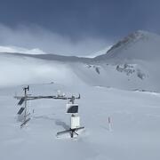
Will McDermott, a physical scientist with the USGS Colorado Water Science Center, working during site visit to Eagle Creek.
William R McDermott
Will is a Physical Scientist with the USGS Colorado Water Science Center in Lakewood, CO.
As a physical scientist in Colorado Rocky Mountains, Will has assisted in a range of hydrologic monitoring projects from aquifer level monitoring in the Eastern plains to installing and maintaining weather and snow stations above 12,000’. Currently, Will’s professional passion involves collecting high quality data on snowpack quantity and characteristics in remote and high-altitude mountainous environments in order to better understand the relationship of water resources from “Snow to Flow”.
Science and Products
Next Generation Water Observing System (NGWOS) Snow Hydrology Monitoring Network in the Upper Colorado River Basin
Representative observations of snowpack conditions are vital for informing water availability assessments and modeling in snow dominated regions of the western United States. The U.S. Geological Survey (USGS) established a snow hydrology monitoring network in 2021 with the objective of providing high-quality, representative, and publicly available data on snowpack, soil moisture, and...

Eagle Creek Site Visit
Will McDermott, a physical scientist with the USGS Colorado Water Science Center, working during site visit to Eagle Creek.

Snow crossing during Eagle Creek site visit
Will McDermott, a physical scientist with the USGS Colorado Water Science Center, working his way across the snow during a site visit at Eagle Creek.
Will McDermott, a physical scientist with the USGS Colorado Water Science Center, working his way across the snow during a site visit at Eagle Creek.
Science and Products
Next Generation Water Observing System (NGWOS) Snow Hydrology Monitoring Network in the Upper Colorado River Basin
Representative observations of snowpack conditions are vital for informing water availability assessments and modeling in snow dominated regions of the western United States. The U.S. Geological Survey (USGS) established a snow hydrology monitoring network in 2021 with the objective of providing high-quality, representative, and publicly available data on snowpack, soil moisture, and...
Eagle Creek Site Visit
Will McDermott, a physical scientist with the USGS Colorado Water Science Center, working during site visit to Eagle Creek.
Will McDermott, a physical scientist with the USGS Colorado Water Science Center, working during site visit to Eagle Creek.
Snow crossing during Eagle Creek site visit
Will McDermott, a physical scientist with the USGS Colorado Water Science Center, working his way across the snow during a site visit at Eagle Creek.
Will McDermott, a physical scientist with the USGS Colorado Water Science Center, working his way across the snow during a site visit at Eagle Creek.