
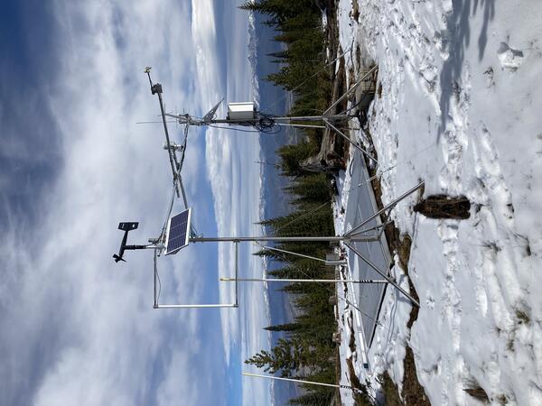
The Berthoud Pass Meteorological Station, Colorado, in March 2023 with peak snowpack conditions. This site is collocated with an NRCS SNOTEL station to compare sensor capabilities and methods.
Next Generation Water Observing System (NGWOS) Snow Hydrology Monitoring Network in the Upper Colorado River Basin
Active
By Colorado Water Science Center
June 4, 2025
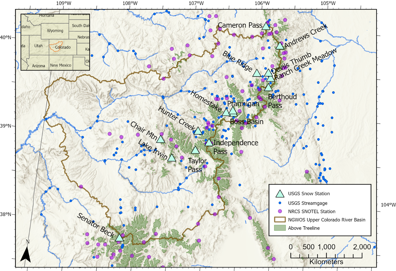
Representative observations of snowpack conditions are vital for informing water availability assessments and modeling in snow dominated regions of the western United States. The U.S. Geological Survey (USGS) established a snow hydrology monitoring network in 2021 with the objective of providing high-quality, representative, and publicly available data on snowpack, soil moisture, and meteorological conditions in the Upper Colorado River Basin. Continuous USGS snow monitoring stations are positioned across a range of land cover types and elevations with placement focused on high elevation alpine areas (greater than 11,000 feet [ft] elevation) and low elevation areas (7,000 – 9,000 ft elevation) to benefit remote sensing and model evaluations, as well as fill current data gaps.
The Next Generation Water Observing System (NGWOS) Upper Colorado River Basin snow hydrology monitoring network consists of 14 snow monitoring stations spread across the Colorado Rocky Mountains (Figure 1, Table 1). Snow monitoring stations range from 8,690 to 12,210 ft in elevation and are positioned within alpine (above treeline), forested, and non-forested land cover types. All stations transmit hourly data values in real time to the USGS Water Data for the Nation database.
Media
Sources/Usage: Public Domain. View Media Details
| Site Name | Location (Decimal Degrees) | Elevation (ft) | Land Cover | NWIS Site ID Number | |
|---|---|---|---|---|---|
| Latitude | Longitude | ||||
| Taylor Pass Meteorological Station, CO | 39.003305 | -106.764863 | 12,239 | Alpine Turf | 390012106455401 |
| Independence Pass Alpine Meteorological Station, CO | 39.106092 | -106.575128 | 12,198 | Alpine Turf | 390622106343001 |
| Senator Beck Meteorological Station NR Ironton, CO | 37.906920 | -107.726490 | 12,160 | Alpine Turf | 375429107433201 |
| Berthoud Pass Meteorological Station, CO | 39.803739 | -105.777932 | 11,306 | Alpine Bedrock and Riparian Shrubland | 394759105464101 |
| Boss Basin Meteorological Station, CO | 39.472308 | -106.262735 | 11,245 | Subalpine Riparian Shrubland | 392820106154601 |
| Ptarmigan Meteorological Station, CO | 39.498445 | -106.273529 | 11,202 | Subalpine Spruce-Fir Forest | 392954106162501 |
| Cameron Pass Meteorological Station, CO | 40.495717 | -105.910478 | 10,787 | Subalpine Spruce-Fir Forest | 402945105543801 |
| Blue Ridge Meteorological Station NR Fraser, CO | 39.952774 | -105.974172 | 10,708 | Lodgepole Pine Forest | 395709105582701 |
| Hunter Creek Meteorological Station Near Aspen, CO | 39.223827 | -106.757325 | 10,600 | Subalpine Spruce-Fir Forest | 391326106452601 |
| Lake Irwin Met Sta Near Ruby Anthracite Creek, CO | 38.884280 | -107.100930 | 10,618 | Alpine Wet Meadow and Spruce-Fir Forest | 385303107060301 |
| Chair Mountain Meteorological Station, CO | 39.079939 | -107.297223 | 10,280 | Subalpine Spruce-Fir Forest | 390447107175001 |
| Ranch CR Meadow Meteorological Sta NR Fraser, CO | 39.913536 | -105.760197 | 9,589 | Evergreen Forest | 395448105453601 |
| Homestake Meteorological Station, CO | 39.469510 | -106.369570 | 8,790 | Subalpine Riparian Shrubland | 392810106221001 |
| Devils Thumb Meteorological Station Near Fraser, CO | 39.969550 | -105.801390 | 8,690 | Lodgepole Pine Forest | 395811105480401 |
Media

Sources/Usage: Public Domain. View Media Details
Each meteorological station measures air temperature, relative humidity, wind speed, wind direction, wind gust speed, incoming and outgoing shortwave radiation, incoming and outgoing longwave radiation, snow depth, snow water equivalent (SWE), and surface temperature as hourly average values. Soil moisture and temperature (5 centimeter [cm] and 20 cm depths), and barometric pressure are measured as hourly instantaneous values. Other novel data types measured are liquid water content of snow, snow density, and blowing snow particle flux. Data are recorded on a Campbell Scientific CR1000X datalogger and telemetered hourly via GOES.
Media
Sources/Usage: Public Domain. View Media Details
Field visits to each station are completed during snow-on and snow-off periods each year. Snow-off station visits prioritize site maintenance, sensor recalibration, discrete meteorological measurements, checking structural integrity of the site, and any upgrades or troubleshooting. Snow-on site visits are scheduled during snow accumulation, peak SWE, and (or) snowmelt periods. The exact timing of these visits is determined by the continuous data being collected at each site, as well as the avalanche safety conditions. Discrete measurements of SWE, snow density, and snow depth are measured during each winter field visit. These measurements support sensor evaluations, quality control for station observations, and assessments of the spatial representativeness of station data to surrounding areas. Discrete snow depths are measured at a centimeter scale spatial precision, and snow pits are used to measure snow density, SWE, and temperature profiles. These discrete snowpack measurements are published in NGWOS Ground Based Discrete Snowpack Measurements, which is updated annually with the most recent project data.

Next Generation Water Observing System (NGWOS)
The Next Generation Water Observing System (NGWOS) supports water availability assessments, management, and prediction by enhancing water observations in basins that represent major U.S. hydrologic regions. NGWOS provides high-resolution, real-time data on water quantity, quality, and use, as well as advance the development and application of new sensor technologies and remote sensing methods.

Next Generation Water Observing System: Upper Colorado River Basin
The Next Generation Water Observing System (NGWOS) provides high-fidelity, real-time data on water quantity, quality, and use to support modern prediction and decision-support systems that are necessary for informing water operations on a daily basis and decision-making during water emergencies. The headwaters of the Colorado and Gunnison River Basins provide an opportunity to implement NGWOS in a...
Berthoud Pass under high snow conditions
The Berthoud Pass Meteorological Station, Colorado, in March 2023 with peak snowpack conditions. This site is collocated with an NRCS SNOTEL station to compare sensor capabilities and methods.

High alpine site at peak snow accumulation
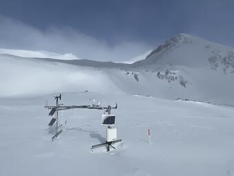
At 12,160 feet, Senator Beck Meteorological Station, Colorado, is one of the higher elevation alpine sites in the network and shows the large amount of snow at these high-altitude catchment environments, as well as sublimation and wind redistribution of snow, a potentially important area to measure for water availability forecasting.
At 12,160 feet, Senator Beck Meteorological Station, Colorado, is one of the higher elevation alpine sites in the network and shows the large amount of snow at these high-altitude catchment environments, as well as sublimation and wind redistribution of snow, a potentially important area to measure for water availability forecasting.
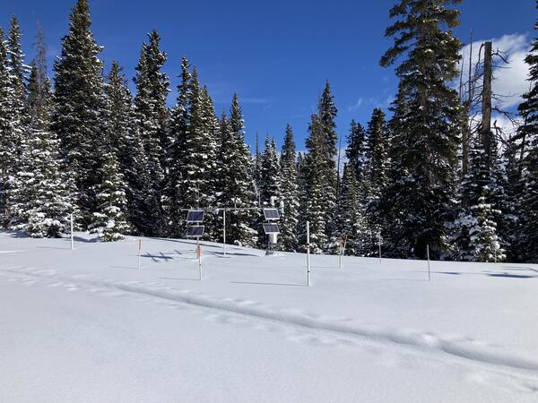
Blue Ridge before snow accumulation
This image shows the Blue Ridge Meteorological Station after installation before snow accumulation. The image is useful to see the station structure and layout of installed sensors as well as the limited snow cover common in the early and late seasons.
This image shows the Blue Ridge Meteorological Station after installation before snow accumulation. The image is useful to see the station structure and layout of installed sensors as well as the limited snow cover common in the early and late seasons.
Representative observations of snowpack conditions are vital for informing water availability assessments and modeling in snow dominated regions of the western United States. The U.S. Geological Survey (USGS) established a snow hydrology monitoring network in 2021 with the objective of providing high-quality, representative, and publicly available data on snowpack, soil moisture, and meteorological conditions in the Upper Colorado River Basin. Continuous USGS snow monitoring stations are positioned across a range of land cover types and elevations with placement focused on high elevation alpine areas (greater than 11,000 feet [ft] elevation) and low elevation areas (7,000 – 9,000 ft elevation) to benefit remote sensing and model evaluations, as well as fill current data gaps.
The Next Generation Water Observing System (NGWOS) Upper Colorado River Basin snow hydrology monitoring network consists of 14 snow monitoring stations spread across the Colorado Rocky Mountains (Figure 1, Table 1). Snow monitoring stations range from 8,690 to 12,210 ft in elevation and are positioned within alpine (above treeline), forested, and non-forested land cover types. All stations transmit hourly data values in real time to the USGS Water Data for the Nation database.
Media
Sources/Usage: Public Domain. View Media Details
| Site Name | Location (Decimal Degrees) | Elevation (ft) | Land Cover | NWIS Site ID Number | |
|---|---|---|---|---|---|
| Latitude | Longitude | ||||
| Taylor Pass Meteorological Station, CO | 39.003305 | -106.764863 | 12,239 | Alpine Turf | 390012106455401 |
| Independence Pass Alpine Meteorological Station, CO | 39.106092 | -106.575128 | 12,198 | Alpine Turf | 390622106343001 |
| Senator Beck Meteorological Station NR Ironton, CO | 37.906920 | -107.726490 | 12,160 | Alpine Turf | 375429107433201 |
| Berthoud Pass Meteorological Station, CO | 39.803739 | -105.777932 | 11,306 | Alpine Bedrock and Riparian Shrubland | 394759105464101 |
| Boss Basin Meteorological Station, CO | 39.472308 | -106.262735 | 11,245 | Subalpine Riparian Shrubland | 392820106154601 |
| Ptarmigan Meteorological Station, CO | 39.498445 | -106.273529 | 11,202 | Subalpine Spruce-Fir Forest | 392954106162501 |
| Cameron Pass Meteorological Station, CO | 40.495717 | -105.910478 | 10,787 | Subalpine Spruce-Fir Forest | 402945105543801 |
| Blue Ridge Meteorological Station NR Fraser, CO | 39.952774 | -105.974172 | 10,708 | Lodgepole Pine Forest | 395709105582701 |
| Hunter Creek Meteorological Station Near Aspen, CO | 39.223827 | -106.757325 | 10,600 | Subalpine Spruce-Fir Forest | 391326106452601 |
| Lake Irwin Met Sta Near Ruby Anthracite Creek, CO | 38.884280 | -107.100930 | 10,618 | Alpine Wet Meadow and Spruce-Fir Forest | 385303107060301 |
| Chair Mountain Meteorological Station, CO | 39.079939 | -107.297223 | 10,280 | Subalpine Spruce-Fir Forest | 390447107175001 |
| Ranch CR Meadow Meteorological Sta NR Fraser, CO | 39.913536 | -105.760197 | 9,589 | Evergreen Forest | 395448105453601 |
| Homestake Meteorological Station, CO | 39.469510 | -106.369570 | 8,790 | Subalpine Riparian Shrubland | 392810106221001 |
| Devils Thumb Meteorological Station Near Fraser, CO | 39.969550 | -105.801390 | 8,690 | Lodgepole Pine Forest | 395811105480401 |
Media
Sources/Usage: Public Domain. View Media Details
Each meteorological station measures air temperature, relative humidity, wind speed, wind direction, wind gust speed, incoming and outgoing shortwave radiation, incoming and outgoing longwave radiation, snow depth, snow water equivalent (SWE), and surface temperature as hourly average values. Soil moisture and temperature (5 centimeter [cm] and 20 cm depths), and barometric pressure are measured as hourly instantaneous values. Other novel data types measured are liquid water content of snow, snow density, and blowing snow particle flux. Data are recorded on a Campbell Scientific CR1000X datalogger and telemetered hourly via GOES.
Media
Sources/Usage: Public Domain. View Media Details
Field visits to each station are completed during snow-on and snow-off periods each year. Snow-off station visits prioritize site maintenance, sensor recalibration, discrete meteorological measurements, checking structural integrity of the site, and any upgrades or troubleshooting. Snow-on site visits are scheduled during snow accumulation, peak SWE, and (or) snowmelt periods. The exact timing of these visits is determined by the continuous data being collected at each site, as well as the avalanche safety conditions. Discrete measurements of SWE, snow density, and snow depth are measured during each winter field visit. These measurements support sensor evaluations, quality control for station observations, and assessments of the spatial representativeness of station data to surrounding areas. Discrete snow depths are measured at a centimeter scale spatial precision, and snow pits are used to measure snow density, SWE, and temperature profiles. These discrete snowpack measurements are published in NGWOS Ground Based Discrete Snowpack Measurements, which is updated annually with the most recent project data.
Next Generation Water Observing System (NGWOS)
The Next Generation Water Observing System (NGWOS) supports water availability assessments, management, and prediction by enhancing water observations in basins that represent major U.S. hydrologic regions. NGWOS provides high-resolution, real-time data on water quantity, quality, and use, as well as advance the development and application of new sensor technologies and remote sensing methods.
Next Generation Water Observing System: Upper Colorado River Basin
The Next Generation Water Observing System (NGWOS) provides high-fidelity, real-time data on water quantity, quality, and use to support modern prediction and decision-support systems that are necessary for informing water operations on a daily basis and decision-making during water emergencies. The headwaters of the Colorado and Gunnison River Basins provide an opportunity to implement NGWOS in a...
Berthoud Pass under high snow conditions
The Berthoud Pass Meteorological Station, Colorado, in March 2023 with peak snowpack conditions. This site is collocated with an NRCS SNOTEL station to compare sensor capabilities and methods.
The Berthoud Pass Meteorological Station, Colorado, in March 2023 with peak snowpack conditions. This site is collocated with an NRCS SNOTEL station to compare sensor capabilities and methods.
High alpine site at peak snow accumulation
At 12,160 feet, Senator Beck Meteorological Station, Colorado, is one of the higher elevation alpine sites in the network and shows the large amount of snow at these high-altitude catchment environments, as well as sublimation and wind redistribution of snow, a potentially important area to measure for water availability forecasting.
At 12,160 feet, Senator Beck Meteorological Station, Colorado, is one of the higher elevation alpine sites in the network and shows the large amount of snow at these high-altitude catchment environments, as well as sublimation and wind redistribution of snow, a potentially important area to measure for water availability forecasting.
Blue Ridge before snow accumulation
This image shows the Blue Ridge Meteorological Station after installation before snow accumulation. The image is useful to see the station structure and layout of installed sensors as well as the limited snow cover common in the early and late seasons.
This image shows the Blue Ridge Meteorological Station after installation before snow accumulation. The image is useful to see the station structure and layout of installed sensors as well as the limited snow cover common in the early and late seasons.