
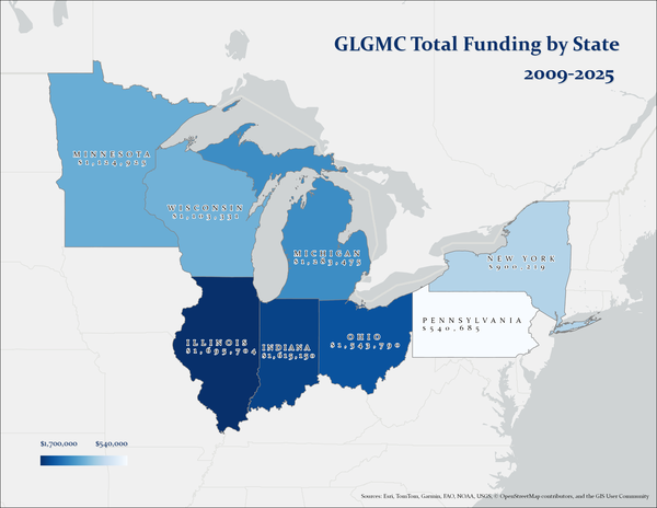
This graphic shows the distribution and total US dollar amount of funding received by each GLGMC member state between 2009 and 2025 since the Coalition has been part of the National Cooperative Geologic Mapping Program.
Images
Images intro.
Filter Total Items: 355
GLGMC Funding history 2009 - 2025
This graphic shows the distribution and total US dollar amount of funding received by each GLGMC member state between 2009 and 2025 since the Coalition has been part of the National Cooperative Geologic Mapping Program.
Annual NLCD animation of Cleveland, Ohio, area, 1985-2023
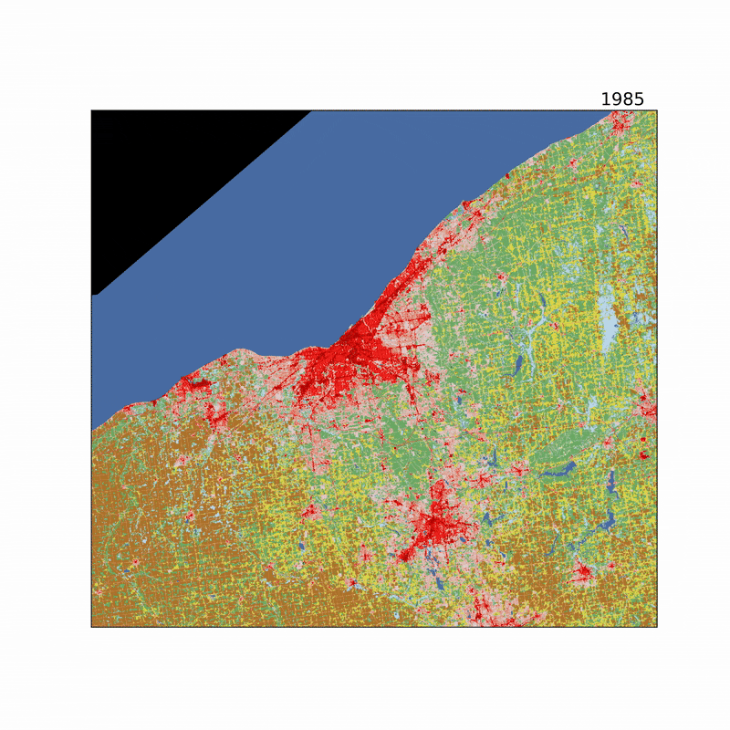
Annual NLCD animation of Cleveland, Ohio, area, 1985-2023This animation for the years 1985 to 2023, from the Annual National Land Cover Database (NLCD) shows the change in urban development over time in the Cleveland, Ohio, area. Production of Annual NLCD is based at the USGS Earth Resources Observation and Science (EROS) Center.
Annual NLCD animation of Cleveland, Ohio, area, 1985-2023
Annual NLCD animation of Cleveland, Ohio, area, 1985-2023This animation for the years 1985 to 2023, from the Annual National Land Cover Database (NLCD) shows the change in urban development over time in the Cleveland, Ohio, area. Production of Annual NLCD is based at the USGS Earth Resources Observation and Science (EROS) Center.

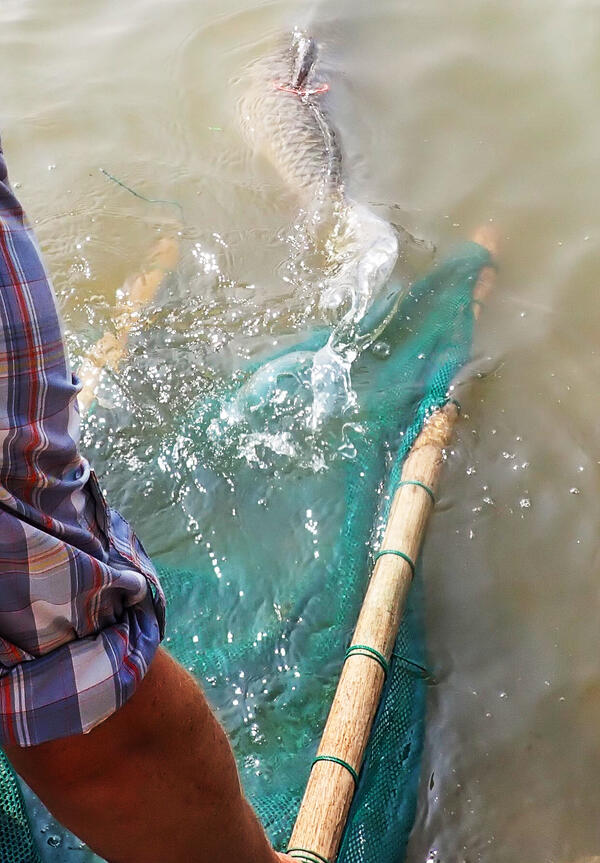
A Lone Net Float
Gill net float at entrance to backwater habitat set to capture Grass Carp in the lower Huron River, OH. Photo credit: James Roberts, USGS.
Gill net float at entrance to backwater habitat set to capture Grass Carp in the lower Huron River, OH. Photo credit: James Roberts, USGS.

Research Vessel Muskie near Cleveland
Crew of the USGS Great Lakes Science Center R/V Muskie (Huron, Ohio) testing bottom trawl equipment in Lake Erie off the coast of Cleveland, Ohio, in preparation for the upcoming field season. Photo credit: Kevin Keretz, USGS-GLSC.
Crew of the USGS Great Lakes Science Center R/V Muskie (Huron, Ohio) testing bottom trawl equipment in Lake Erie off the coast of Cleveland, Ohio, in preparation for the upcoming field season. Photo credit: Kevin Keretz, USGS-GLSC.

Tuggin' Along
A USGS wetland scientist (GLSC; Ann Arbor, Michigan) pulls a small boat containing cut, invasive Phragmites australis during wetlands field work at Metzger Marsh on the shore of Lake Erie in Ohio. Photo credit: Anthony Rondon, USGS.
A USGS wetland scientist (GLSC; Ann Arbor, Michigan) pulls a small boat containing cut, invasive Phragmites australis during wetlands field work at Metzger Marsh on the shore of Lake Erie in Ohio. Photo credit: Anthony Rondon, USGS.

Surprise Catch
A juvenile lake sturgeon (Acipenser fulvescens) captured during a bottom trawl survey in Lake Erie aboard the GLSC’s R/V Muskie. Photo credit: Kevin Keretz, USGS.
A juvenile lake sturgeon (Acipenser fulvescens) captured during a bottom trawl survey in Lake Erie aboard the GLSC’s R/V Muskie. Photo credit: Kevin Keretz, USGS.
Jon Boat Journey
A USGS wetland scientist (GLSC; Ann Arbor, Michigan) walks alongside a treated invasive Phragmites australis site. Photo credit: Taaja Tucker-Silva, USGS.
A USGS wetland scientist (GLSC; Ann Arbor, Michigan) walks alongside a treated invasive Phragmites australis site. Photo credit: Taaja Tucker-Silva, USGS.
Wetland Scientist
A USGS wetland scientist (GLSC; Ann Arbor, Michigan) counts the number of invasive Phragmites australis stems within a sampling quadrat in an effort to provide information about various control strategies used to manage the plant. Photo credit: Taaja Tucker-Silva, USGS.
A USGS wetland scientist (GLSC; Ann Arbor, Michigan) counts the number of invasive Phragmites australis stems within a sampling quadrat in an effort to provide information about various control strategies used to manage the plant. Photo credit: Taaja Tucker-Silva, USGS.

Lake Erie Saildrone Sampling Tracks for 2023
A map of Lake Erie that includes the rough dates of operation of autonomous and crewed vehicles by USGS, Saildrone, Monterey Bay Aquarium Research Institute (MBARI), and State and Ontario partners throughout Lake Erie during summer 2023.
A map of Lake Erie that includes the rough dates of operation of autonomous and crewed vehicles by USGS, Saildrone, Monterey Bay Aquarium Research Institute (MBARI), and State and Ontario partners throughout Lake Erie during summer 2023.

Phragmites
A USGS field crew (GLSC; Ann Arbor, Michigan) on an excursion in Metzger Marsh on Lake Erie to monitor invasive Phragmites australis. Photo credit: Kaira Liggett, USGS Contractor.
A USGS field crew (GLSC; Ann Arbor, Michigan) on an excursion in Metzger Marsh on Lake Erie to monitor invasive Phragmites australis. Photo credit: Kaira Liggett, USGS Contractor.
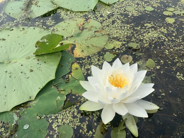
Water Lily
A water lily (Nymphaea) in full bloom surrounded by European frog-bit (Hydrocharis morsus-ranae), and Duckweed (Lemnaceae) in Mezger Marsh, part of the Ottawa National Wildlife Refuge on Lake Erie in Ohio. Photo credit: Kaira Liggett, USGS Contractor.
A water lily (Nymphaea) in full bloom surrounded by European frog-bit (Hydrocharis morsus-ranae), and Duckweed (Lemnaceae) in Mezger Marsh, part of the Ottawa National Wildlife Refuge on Lake Erie in Ohio. Photo credit: Kaira Liggett, USGS Contractor.
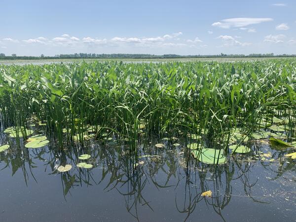
Summertime Marsh
Aquatic vegetation, including arrowhead (Sagittaria), water lily (Nymphaea), lotus (Nelumbo) and European frog-bit (Hydrocharis morsus-ranae), photographed in Metzger Marsh, part of the Ottawa National Wildlife Refuge on Lake Erie in Ohio. Photo credit: Kaira Liggett, USGS Contractor.
Aquatic vegetation, including arrowhead (Sagittaria), water lily (Nymphaea), lotus (Nelumbo) and European frog-bit (Hydrocharis morsus-ranae), photographed in Metzger Marsh, part of the Ottawa National Wildlife Refuge on Lake Erie in Ohio. Photo credit: Kaira Liggett, USGS Contractor.
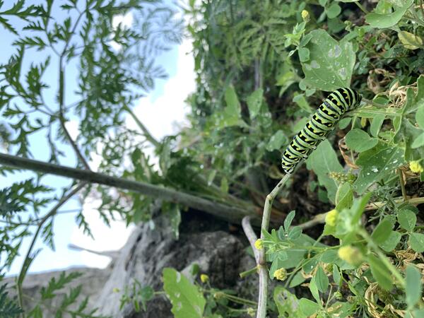
Black Swallowtail Caterpillar
A black swallowtail caterpillar (Papilio polyxenes) feeding on vegetation at the Metzger Marsh boat launch, part of the Ottawa National Wildlife Refuge on Lake Erie in Ohio. Photo credit: Kaira Liggett, USGS Contractor.
A black swallowtail caterpillar (Papilio polyxenes) feeding on vegetation at the Metzger Marsh boat launch, part of the Ottawa National Wildlife Refuge on Lake Erie in Ohio. Photo credit: Kaira Liggett, USGS Contractor.

Down the Pipe
A bottom trawl being deployed by USGS biological science technicians (GLSC; Huron, Ohio) aboard the GLSC’s R/V Muskie. Photo credit: Kevin Keretz, USGS.
A bottom trawl being deployed by USGS biological science technicians (GLSC; Huron, Ohio) aboard the GLSC’s R/V Muskie. Photo credit: Kevin Keretz, USGS.
Releasing a Grass Carp with an Acoustic Tag
Tagged Grass Carp swimming away after being release post telemetry surgery into the Sandusky River, OH. Photo credit: James Roberts, USGS.
Tagged Grass Carp swimming away after being release post telemetry surgery into the Sandusky River, OH. Photo credit: James Roberts, USGS.

Lake Erie Gold
The USGS research crew (GLSC; Huron, OH) aboard the R/V Muskie celebrate a large catch of adult yellow perch (Perca flavescens) to be tagged with acoustic transmitters and then released back into Lake Erie for tracking. Photo credit: Kevin Keretz, USGS.
The USGS research crew (GLSC; Huron, OH) aboard the R/V Muskie celebrate a large catch of adult yellow perch (Perca flavescens) to be tagged with acoustic transmitters and then released back into Lake Erie for tracking. Photo credit: Kevin Keretz, USGS.

Principal aquifers and wells assessed in nationwide NAWQA/GAMA groundwater quality study
Principal aquifers and wells assessed in nationwide NAWQA/GAMA groundwater quality studyMap showing principal aquifers (PAs) and wells that were sampled as part of a Nationwide assessment of the quality of groundwater used for public supply.
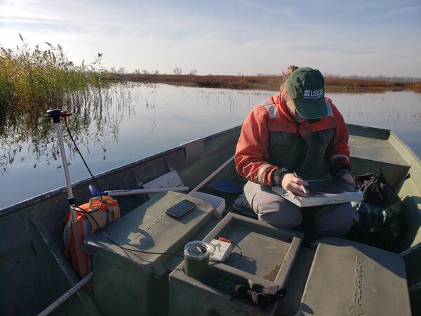
Mapping Wetland Vegetation
USGS ecologist (GLSC; Ann Arbor, Michigan) uses GPS gear to map wetland vegetation at Metzger Marsh at the Ottawa National Wildlife Refuge on the shore of Lake Erie in Ohio. Photo credit: Kurt Kowalski, USGS.
USGS ecologist (GLSC; Ann Arbor, Michigan) uses GPS gear to map wetland vegetation at Metzger Marsh at the Ottawa National Wildlife Refuge on the shore of Lake Erie in Ohio. Photo credit: Kurt Kowalski, USGS.

Breaking the Surface
Lotus pads (Nelumbo lutea) and cattails (Typha sp.) emerging in the Metzger Marsh Wildlife Area adjacent to Lake Erie. Photo credit: Kaira Liggett, USGS (contractor).
Lotus pads (Nelumbo lutea) and cattails (Typha sp.) emerging in the Metzger Marsh Wildlife Area adjacent to Lake Erie. Photo credit: Kaira Liggett, USGS (contractor).

Cutting Down an Invasive Species
USGS Biologist Wes Bickford cutting invasive Phragmites australis underwater. Credit: Spencer Widin, USGS
USGS Biologist Wes Bickford cutting invasive Phragmites australis underwater. Credit: Spencer Widin, USGS

Phragmites, Cut-to-Drown
GLSC’s Kaira Liggett next to a floating mass of cut Phragmites at Metzger Marsh in Oak Harbor, OH. Photo credit: Wes Bickford, USGS.
GLSC’s Kaira Liggett next to a floating mass of cut Phragmites at Metzger Marsh in Oak Harbor, OH. Photo credit: Wes Bickford, USGS.