
USGS Great Lakes Science Center technician Jared Lesniewicz processes an ichthyoplankton sample during a survey assessing grass carp spawning in the Cuyahoga River, a Lake Erie tributary in Cleveland, Ohio. As of the 2024 sampling season, no grass carp spawning has been documented in the Cuyahoga River. Photo Credit: James Roberts, USGS.
Images
Images intro.
Filter Total Items: 355

Sampling at an Elevated Railroad Bridge
USGS Great Lakes Science Center technician Jared Lesniewicz processes an ichthyoplankton sample during a survey assessing grass carp spawning in the Cuyahoga River, a Lake Erie tributary in Cleveland, Ohio. As of the 2024 sampling season, no grass carp spawning has been documented in the Cuyahoga River. Photo Credit: James Roberts, USGS.

Friendly Bass
In Lake Erie, a USGS scuba diver swims with a smallmouth bass (Micropterus dolomieu) who is curious about the diver’s algae and mussel collections. Photo credit: Madeleine Giordano, USGS.
In Lake Erie, a USGS scuba diver swims with a smallmouth bass (Micropterus dolomieu) who is curious about the diver’s algae and mussel collections. Photo credit: Madeleine Giordano, USGS.

Grass Carp Eggs
An ichthyoplankton net sample within a collection bucket from the Sandusky River in May of 2022. Grass carp (Ctenopharyngodon idella) eggs are pictured in the foreground (semi-transparent spheres). Photo Credit: James Roberts, USGS
An ichthyoplankton net sample within a collection bucket from the Sandusky River in May of 2022. Grass carp (Ctenopharyngodon idella) eggs are pictured in the foreground (semi-transparent spheres). Photo Credit: James Roberts, USGS

The Lake Erie Biological Station's new location
The Lake Erie Biological Station, a field station of the Great Lakes Science Center, moved from Sandusky Ohio to a new building in Huron Ohio in March 2022.
The Lake Erie Biological Station, a field station of the Great Lakes Science Center, moved from Sandusky Ohio to a new building in Huron Ohio in March 2022.
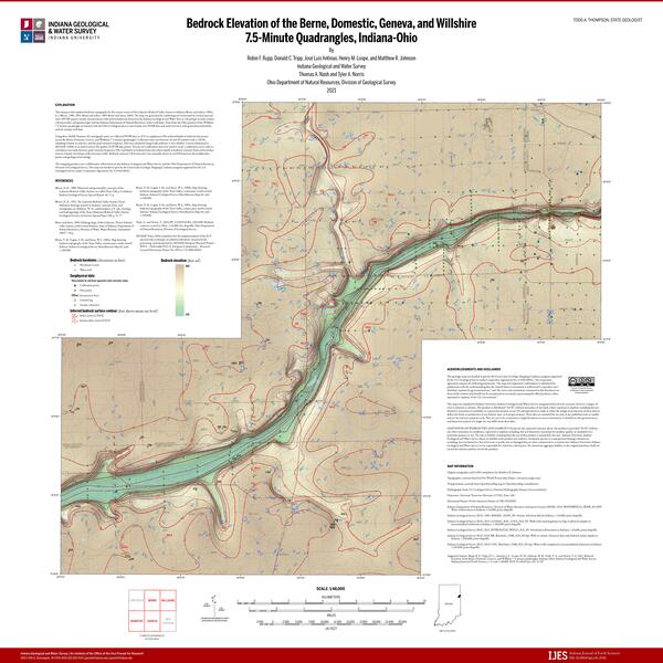
Bedrock Elevation of the Berne, Domestic, Geneva, and Willshire 7.5-Minute Quadrangles, Indiana-Ohio
Bedrock Elevation of the Berne, Domestic, Geneva, and Willshire 7.5-Minute Quadrangles, Indiana-OhioThis map is an updated bedrock topography map for the eastern extent of the Lafayette Bedrock Valley System in Indiana and Ohio which depicts a portion of an ancient river drainage valley. This image is used with the permission of the Indiana Geological and Water Survey and the Ohio Department of Natural Resources, Division of Geological Survey.

Landsat 9 First Light Detroit & Lake Erie
Sediments swirl in Lake Erie and Lake St. Clair in this Landsat 9 image of both Detroit, Michigan, and Windsor, Ontario, from Oct. 31, 2021. The Great Lakes serve as sources of freshwater, recreational activity, transport, and habitat for the upper-midwestern US, and water quality remains a high priority.
Sediments swirl in Lake Erie and Lake St. Clair in this Landsat 9 image of both Detroit, Michigan, and Windsor, Ontario, from Oct. 31, 2021. The Great Lakes serve as sources of freshwater, recreational activity, transport, and habitat for the upper-midwestern US, and water quality remains a high priority.
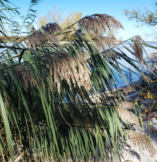
A Phragmites australis Stand at Crane Creek in Ohio
A Phragmites australis Stand at Crane Creek in OhioA Phragmites australis stand at Crane Creek in the Ottawa National Wildlife Refuge, Ohio. P. australis is an invasive species in North America.
A Phragmites australis Stand at Crane Creek in Ohio
A Phragmites australis Stand at Crane Creek in OhioA Phragmites australis stand at Crane Creek in the Ottawa National Wildlife Refuge, Ohio. P. australis is an invasive species in North America.

Phragmites invades coastal wetland in a changing climate
Phragmites invades coastal wetland in a changing climatePhragmites invades coastal wetland in a changing climate. Ottawa National Wildlife Refuge, Oak Harbor, OH. Photo Credit: Kurt Kowalski, USGS-GLSC.
Phragmites invades coastal wetland in a changing climate
Phragmites invades coastal wetland in a changing climatePhragmites invades coastal wetland in a changing climate. Ottawa National Wildlife Refuge, Oak Harbor, OH. Photo Credit: Kurt Kowalski, USGS-GLSC.

Retrieving a Sample
A USGS field team member retrieving the sample bottle from a time-based sampler onsite at a wastewater treatment facility.
A USGS field team member retrieving the sample bottle from a time-based sampler onsite at a wastewater treatment facility.
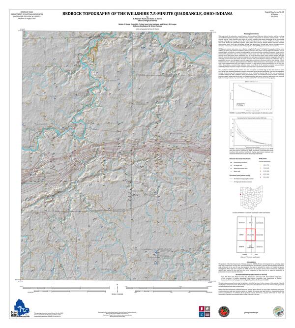
Bedrock Topography of the Willshire 7.5-minute Quadrangle, Ohio-Indiana
Bedrock Topography of the Willshire 7.5-minute Quadrangle, Ohio-IndianaThis map details the subsurface contact between the consolidated Paleozoic bedrock surface and the overlying unconsolidated Quaternary-aged sediments. This image is used with the permission of the Ohio Department of Natural Resources, Division of Geological Survey and the Indiana Geological and Water Survey.

Emergent Vegetation in a Wetland
Landscape view of two researchers walking through the emergent vegetation zone of a Great Lakes coastal wetland. Photo Credit: Alexandra (Sasha) Bozimowski, USGS.
Landscape view of two researchers walking through the emergent vegetation zone of a Great Lakes coastal wetland. Photo Credit: Alexandra (Sasha) Bozimowski, USGS.

Vessels Sampling in a River in Ohio
Vessels like this use various sampling methods to collect fish at all life stages, adult, larvae, and eggs.
Vessels like this use various sampling methods to collect fish at all life stages, adult, larvae, and eggs.

Tracking the Movement of Grass Carp in the Sandusky River, 2016
Tracking the Movement of Grass Carp in the Sandusky River, 2016Nicole King (University of Toledo graduate student) holding a Grass Carp. The Ohio Department of Natural Resources and Michigan State University responded to a report from a commercial fisherman that grass carp were being captured in the Sandusky River. Researchers captured, tagged, and released grass carp to track their movements.

Vermillion River near Vermillion OH - frozen waterfall
Vermillion River near Vermillion OH - frozen waterfallVermillion River near Vermillion OH - frozen waterfall
Vermillion River near Vermillion OH - frozen waterfall
Vermillion River near Vermillion OH - frozen waterfallVermillion River near Vermillion OH - frozen waterfall

Young Raccoon Watches from Afar
A curious young raccoon peers in on GLSC researchers as they walk through a wetland in Ohio on the way to a study site.
A curious young raccoon peers in on GLSC researchers as they walk through a wetland in Ohio on the way to a study site.

Sheldon Marsh State Nature Preserve, Ohio
Sheldon Marsh State Nature Preserve, near Sandusky Ohio taken on 30 July 2020 for the GLSC Photo Challenge
Sheldon Marsh State Nature Preserve, near Sandusky Ohio taken on 30 July 2020 for the GLSC Photo Challenge

Map of the super gage site locations in Ohio, Kentucky, and Indiana
Map of the super gage site locations in Ohio, Kentucky, and IndianaMap of the super gage site locations in Ohio, Kentucky, and Indiana
Map of the super gage site locations in Ohio, Kentucky, and Indiana
Map of the super gage site locations in Ohio, Kentucky, and IndianaMap of the super gage site locations in Ohio, Kentucky, and Indiana

Grass carp larvae
These images show grass carp larvae from the Maumee River. Characteristics of larval grass carp include overall length (left), skeletal muscle development (center) and presence of an eye spot that lacks pigmentation (right; pigment starting to develop on lower eye).
These images show grass carp larvae from the Maumee River. Characteristics of larval grass carp include overall length (left), skeletal muscle development (center) and presence of an eye spot that lacks pigmentation (right; pigment starting to develop on lower eye).

Aging a Fish Using a Spine
A pectoral spine cross section from invasive grass carp captured in the Great Lakes. These cross sections are used to determine the age of the fish.
A pectoral spine cross section from invasive grass carp captured in the Great Lakes. These cross sections are used to determine the age of the fish.

Aging a Fish Using a Vertebra Cross Section
Cross section of a fish vertebra. Useful for determining the age of a fish.
Cross section of a fish vertebra. Useful for determining the age of a fish.

Dr. Ed Roseman Delivers Plenary Address to AOC Meeting in Cleveland
Dr. Ed Roseman Delivers Plenary Address to AOC Meeting in ClevelandGSLC research fish biologist, Dr. Ed Roseman, delivers a plenary address at the Great Lakes Areas of Concern (AOC) conference on September 11-12, 2019.
Dr. Ed Roseman Delivers Plenary Address to AOC Meeting in Cleveland
Dr. Ed Roseman Delivers Plenary Address to AOC Meeting in ClevelandGSLC research fish biologist, Dr. Ed Roseman, delivers a plenary address at the Great Lakes Areas of Concern (AOC) conference on September 11-12, 2019.