
Grass Carp Eggs being examined under a microscope to determine developmental stage.
Images
Images intro.
Filter Total Items: 355

Grass Carp Eggs Under a Microscope
Grass Carp Eggs being examined under a microscope to determine developmental stage.
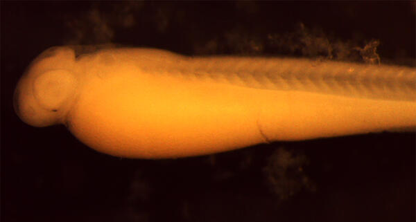
Maumee River Grass Carp Larva
A Grass Carp larva captured during a survey in the Maumee River, a Lake Erie tributary. Grass Carp are an invasive species that consume vegetation destroying habitat used by other species.
A Grass Carp larva captured during a survey in the Maumee River, a Lake Erie tributary. Grass Carp are an invasive species that consume vegetation destroying habitat used by other species.

Confined disposal facility, East Chicago, Indiana
Front cover for the publication titled "Geochemistry and microbiology of groundwater and solids from extraction and monitoring wells and their relation to well efficiency at a Federally operated confined disposal facility, East Chicago, Indiana"
Front cover for the publication titled "Geochemistry and microbiology of groundwater and solids from extraction and monitoring wells and their relation to well efficiency at a Federally operated confined disposal facility, East Chicago, Indiana"
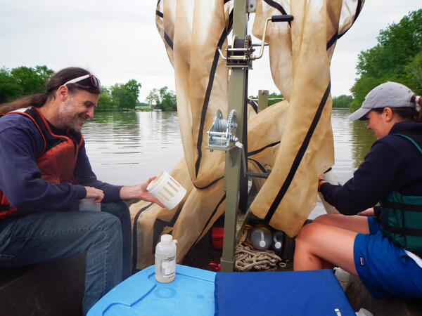
Scientists Looking for Grass Carp Larvae
Dr. Patrick Kocovsky and Maddy Tomczak, University of Toledo student, look for Grass Carp lavae and eggs in the Sandusky River using a set of bongo nets, so named because they resemble bongo drums. The nets are deployed one above the other so that one samples the surface water while the other samples deeper water.
Dr. Patrick Kocovsky and Maddy Tomczak, University of Toledo student, look for Grass Carp lavae and eggs in the Sandusky River using a set of bongo nets, so named because they resemble bongo drums. The nets are deployed one above the other so that one samples the surface water while the other samples deeper water.

Eagle Creek at Zionsville, IN - downstream of gage
Eagle Creek at Zionsville, IN - downstream of gageEagle Creek at Zionsville, IN - downstream of gage
Eagle Creek at Zionsville, IN - downstream of gage
Eagle Creek at Zionsville, IN - downstream of gageEagle Creek at Zionsville, IN - downstream of gage

Phragmites australis on the Shore of Lake St. Clair
Phragmites australis on the Shore of Lake St. ClairPhragmites australis on the Shore of Lake St. Clair, 2015
Phragmites australis on the Shore of Lake St. Clair
Phragmites australis on the Shore of Lake St. ClairPhragmites australis on the Shore of Lake St. Clair, 2015

National Oil and Gas Assessment Provinces
This is a graphic from the USGS National Oil and Gas Assessment Explorer application, which allows user to drill into 70 oil and gas assessment provinces throughout the United States.
This is a graphic from the USGS National Oil and Gas Assessment Explorer application, which allows user to drill into 70 oil and gas assessment provinces throughout the United States.

USGS Columbus, Ohio office
The USGS Ohio Water Science Center located in Colubumbus, Ohio. The OH WSC is part of the Ohio-Kentucky-Indiana WSC.
The USGS Ohio Water Science Center located in Colubumbus, Ohio. The OH WSC is part of the Ohio-Kentucky-Indiana WSC.

Grand River near Painesville, OH - construction at gage
Grand River near Painesville, OH - construction at gageGrand River near Painesville, OH - construction at gage
Grand River near Painesville, OH - construction at gage
Grand River near Painesville, OH - construction at gageGrand River near Painesville, OH - construction at gage

Grand River near Painesville, OH - downstream
Grand River near Painesville, OH - downstream

Grand River near Painesville, OH - construction
Grand River near Painesville, OH - construction

Grand River near Painesville, OH - railway bridge
Grand River near Painesville, OH - railway bridge

Grand River near Painesville, OH - railway bridge at site
Grand River near Painesville, OH - railway bridge at siteGrand River near Painesville, OH - railway bridge at site
Grand River near Painesville, OH - railway bridge at site
Grand River near Painesville, OH - railway bridge at siteGrand River near Painesville, OH - railway bridge at site

Grand River near Painesville, OH - railway bridge at site
Grand River near Painesville, OH - railway bridge at siteGrand River near Painesville, OH - railway bridge at site
Grand River near Painesville, OH - railway bridge at site
Grand River near Painesville, OH - railway bridge at siteGrand River near Painesville, OH - railway bridge at site

Grand River near Painesville, OH - downstream view
Grand River near Painesville, OH - downstream viewGrand River near Painesville, OH - downstream view
Grand River near Painesville, OH - downstream view
Grand River near Painesville, OH - downstream viewGrand River near Painesville, OH - downstream view

Grand River near Painesville, OH - low flow
Grand River near Painesville, OH - low flow

Grand River near Painesville, OH - view from bridge
Grand River near Painesville, OH - view from bridgeGrand River near Painesville, OH - view from bridge
Grand River near Painesville, OH - view from bridge
Grand River near Painesville, OH - view from bridgeGrand River near Painesville, OH - view from bridge

Grand River near Painesville, OH - construction at site
Grand River near Painesville, OH - construction at siteGrand River near Painesville, OH - construction at site
Grand River near Painesville, OH - construction at site
Grand River near Painesville, OH - construction at siteGrand River near Painesville, OH - construction at site

Maumee River Watershed
The Maumee River Watershed with Areas of Concern
The Maumee River Watershed with Areas of Concern

Field of Phragmites
Field of Phragmites near Cedar Point, Ohio.
Field of Phragmites near Cedar Point, Ohio.

Treating Phragmites in the Laboratory
The untreated non-native Phragmites plant (left) appears healthy; the organically treated plants (right) appear dead.
The untreated non-native Phragmites plant (left) appears healthy; the organically treated plants (right) appear dead.