
GIS Data Download
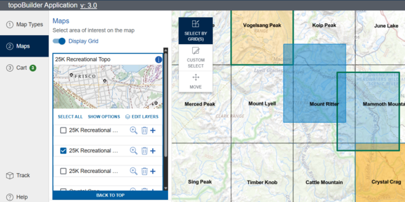
topoBuilder
Create custom USGS topographic maps on demand using the best available data from The National Map
Welcome to The National Map GIS Data Download page
This page provides details on how to access a wide collection of geospatial datasets, serving as useful resources for researchers, planners, decision-makers, and everyday citizens.
Page Navigation: Downloader | LidarExplorer | Advanced Access | Tools | Additional Resources
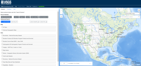
The National Map Downloader
The National Map Downloader is the primary National Map data download application. Elevation, hydrography, geographic names, structures, boundaries, transportation, and many more datasets are available for download in a variety of formats and sizes.
Training videos on National Map data and applications, including The National Map Downloader, are also available.
| Data Category | Description | Learn More |
|---|---|---|
| Boundaries | Aggregated federal land and administrative boundaries from The National Map's National Boundary Dataset. | Supporting Themes |
| Elevation | Digital elevation models (DEMs) & source data (Lidar, IfSAR) from the 3D Elevation Program and 1:24,000-scale contours. | About 3DEP Products & Services |
| Hydrography | Surface water and related data from the National Hydrography Dataset (legacy), the Watershed Boundary Dataset (legacy), and the 3D Hydrography Program. | Access 3DHP Data Products |
| Imagery * | Aerial imagery acquired by the U.S. Department of Agriculture's National Agriculture Imagery Program (NAIP). * | Supporting Themes |
| Map Indices | Grids formed from lines of latitude and longitude that divide the United States into quadrangle extents used in traditional USGS series maps. | U.S. Geological Survey Map Scales |
| Names | Place names from the Geographic Names Information System (GNIS) | About GNIS Data Products |
| Small-scale | Legacy 1:1,000,000-scale contours, hydrography, transportation, and boundaries data that were originally developed for the 1997-2014 National Atlas. These data are not maintained. | Small-scale Data |
| Structures | Structures point data, including public buildings, emergency services, and recreation features, from The National Map's National Structures Dataset. | |
| Topo Map Data and Topo Stylesheet | Data and template packaged by 7.5-minute extent for GIS users to create a customizable US Topo-style map. | Topo TNM Style Template |
| Topobathy - Elevation | Topobathymetric DEMs and source lidar from select 3DEP projects. | Inland Bathymetry |
| Transportation | Roads, airports, railroads, trails, and more infrastructure features from The National Map's National Transportation Dataset. | |
| Woodland Tint | Woodland tint derived from the National Land Cover Database (NLCD) data used in USGS topographic maps. |
Please see the Datasets List for further explanation of downloadable National Map products.
Looking for topo maps? US Topo and historical USGS topographic maps are also available through The National Map Downloader. See Topographic Map Access Points for full details.
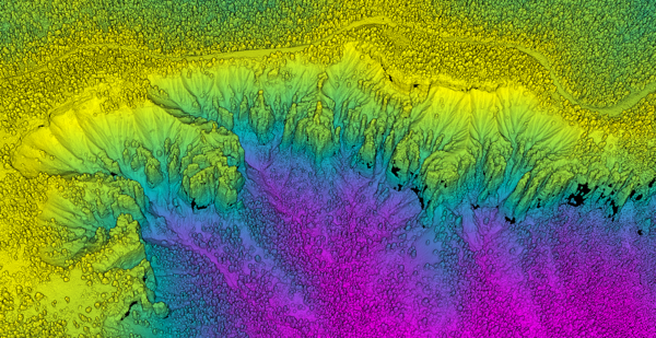
Download and Visualize Lidar Data
3DEP lidar point clouds and DEMs are also available for download through the elevation data-focused LidarExplorer application. Search is aided by an easy-to-use area of interest tool as well as lidar quality level and DEM resolution availability services. Project metadata, download sizes, and coverage are also included in results for simpler product comparison.
Additionally, LidarExplorer enables 3D visualization of lidar point clouds in the web browser and limited within-cloud processing of data prior to download.
For faster, very large volume access to 3DEP lidar data, please see the Lidar Point Cloud in AWS - Requester Pays Instructions.
Advanced Data Download Access Methods
TNM Cloud Downloads (Staged Products)
Direct access to datasets and maps via standard HTTP clients. Retrieve data seamlessly through HTTP endpoints.
Direct access to lidar point clouds, also available through the USGS Rockyweb file directory.
Access map layers in real time via REST, WCS, WMS, WMTS, or WFS instead of downloading files.
Application programming interface (API) to help developers access the National Map’s datasets, notifications, products and services.
uGet Guidance (Bulk Downloads)
Instructions on how to download and use the open-source download manager tool, utilizing the URL lists available through TNM Downloader for bulk data access. See also The National Map Download Manager training video.
Tools
Scripts to convert raster data into other formats (GeoTIFF, JP2, IMG, etc.).
Elevation Point Query Service (EPQS)
Service that returns the ground elevation at any specified latitude/longitude using the 3DEP elevation service. Does not require GIS software.
EPQS for multiple point. Requires longitude and latitude to be on a single line separated by a comma (e.g. -100.01,38.10).
TNM Web Services UpTime Monitor
Monitoring webpage for TNM services.
Application to visualize and research products and downloads from TNM.
Additional Resources
Access current and historical imagery as well as other data through the USGS Earth Resources Observation and Science (EROS) search and download application. Training videos are available.
* The National Map enables access to individual NAIP image downloads through the USGS NAIP Imagery Index Service. Download is through EarthExplorer. Please note NAIP is available for CONUS, PR, USVI and HI.
- An EarthExplorer account is required.
- EarthExplorer is the recommended application for bulk download.
Access geospatial imagery, products, and services before, during, and after a disaster through the Hazards Data Distribution System.