| Feature Class |
Description |
| Arch |
Natural arch-like opening in a rock mass (bridge, natural bridge, sea arch). |
| Area |
Any one of several areally extensive natural features not included in other categories (badlands,
barren, delta, fan, garden). |
| Arroyo |
Colloquial usage in southwestern United States. The valley of an ephemeral stream with a flat floor
and steep banks or the ephemeral stream flowing through a valley with a flat floor and steep banks,
either hydrographic or hypsographic (draw, wash, gully). |
| Bar |
Natural accumulation of sand, gravel, or alluvium forming an underwater or exposed embankment
(ledge, reef, sandbar, shoal, spit). |
| Basin |
Natural depression or relatively low area enclosed by higher land (amphitheater, cirque, pit, sink). |
| Bay |
Indentation of a coastline or shoreline enclosing a part of a body of water; a body of water partly
surrounded by land (arm, bight, cove, estuary, gulf, inlet, sound). |
| Beach |
The sloping shore along a body of water that is washed by waves or tides and is usually covered by
sand or gravel (coast, shore, strand). |
| Bench |
Area of level to gently sloping land on the flank of an elevation such as a hill, ridge, or mountain
where the slope of the land rises on one side and descends on the opposite side (first bottom,
flood-plain step, level, terrace, tread). |
| Bend |
Curve in the course of a stream and (or) the land within the curve; a curve in a linear body of
water (bottom, loop, meander). |
| Canal |
Waterway, primarily manmade, used by watercraft or for drainage, irrigation, mining, or
waterpower (ditch, lateral, sluice). |
| Cape |
Projection of land extending into a body of water (lea, neck, peninsula, point). |
| Census |
A statistical area delineated locally specifically for the tabulation of Census Bureau data (census
designated place, census county division, unorganized territory, various types of
American Indian/Alaska Native statistical areas). Distinct from Civil and Populated Place. |
| Channel |
Linear deep part of a body of water through which the main volume of water flows and is frequently
used as a route for watercraft (passage, reach, strait, thoroughfare, throughfare).
Not a Stream or Valley. |
| Civil |
A political division formed for administrative purposes (borough, county, incorporated place,
municipio, parish, town, township). Distinct from Census and Populated Place. |
| Cliff |
Very steep or vertical slope on one side (bluff, crag, escarpment, head, headland, nose, palisades,
precipice, promontory, rim, rimrock, scarp). |
| Crater |
Circular-shaped depression at the summit of a volcanic cone or one on the surface of the land caused
by the impact of a meteorite; a manmade depression caused by an explosion
(bowl, caldera, lua, maar). |
| Crossing |
A place at which a river or stream may be crossed (landing, ferry, ford). |
| Falls |
Perpendicular or very steep fall of water in the course of a stream (cascade, cataract, waterfall). |
| Flat |
Relative level area within a region of greater relief (clearing, glade, pan, park, playa lake,
salina, upland) |
| Gap |
Low point or opening between hills or mountains or in a ridge or mountain range (col, notch, pass,
saddle, water gap, wind gap). |
| Glacier |
Body or stream of ice moving outward and downslope from an area of accumulation; an area of
relatively permanent snow or ice on the top or side of a mountain or mountainous area (icefield,
ice patch, snow patch). |
| Gut |
Relatively small coastal waterway connecting larger bodies of water or other waterways
(creek, inlet, slough). |
| Island |
Area of dry or relatively dry land surrounded by water or low wetland (archipelago, atoll, cay,
hammock, hummock, isla, isle, key, moku, rock). |
| Isthmus |
Narrow section of land in a body of water connecting two larger land areas. |
| Lake |
Natural body of inland water (backwater, lac, lagoon, laguna, oxbow, pond, pool, resaca,
tank, tarn, waterhole). |
| Lava |
Formations resulting from the consolidation of molten rock on the surface of the Earth (kepula,
lava flow, māwae, traps). |
| Levee |
Natural or manmade embankment flanking a stream (bank, berm). |
| Military |
Place or facility used for various aspects of or relating to military activity. |
| Pillar |
Vertical, standing, often spire-shaped, natural rock formation (chimney, hoodoo, monument,
pinnacle, pōhaku, rock tower). |
| Plain |
A region of general uniform slope, comparatively level and of considerable extent; can refer to the
flat area of a large mesa (desert, grassland, highland, kula, plateau, savanna). |
| Populated Place |
Place or area with clustered or scattered buildings and a permanent human population (city,
settlement, town, village). A populated place is usually not incorporated and by definition
has no legal boundaries. However, a populated place may have a corresponding "civil" record,
the legal boundaries of which may or may not coincide with the perceived populated place.
Distinct from Census and Civil classes. |
| Range |
A single mass of hills or mountains; a complex, interconnected series of mountain ranges having
a well-defined longitudinal trend (cordillera, mountain belt, sierra). |
| Rapids |
Fast-flowing section of a stream with turbulent flow, often shallow and with exposed rock or
boulders, wheredischarge is mostly influenced by velocity rather than width and depth
(dalles, riffle, ripple). |
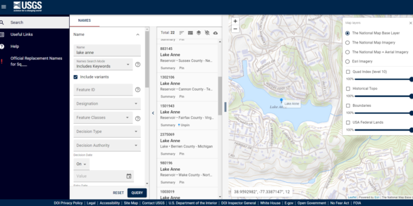
| Reservoir |
Artificially impounded body of water (lake, tank). |
| Ridge |
Elevation with a narrow, elongated crest that can be part of a hill or mountain (arête, crest, chenier,
cuesta, divide, esker, hogback, mogote, lae, ridge, spur). |
| Sea |
Large body of salt water (gulf, ocean). |
| Slope |
A gently inclined part of the Earth's surface (grade, pitch). |
| Spring |
Place where underground water flows naturally to the surface of the Earth (seep). |
| Stream |
Linear body of water flowing on the Earth's surface (anabranch, awāwa, bayou, branch, brook, creek,
distributary, fork, kill, pup, rio, river, run, slough) |
| Summit |
Prominent elevation rising above the surrounding level of the Earth's surface; does not include
pillars, ridges, or ranges; can occur as a single isolated mass or in a group (ahu, ballon, berg,
bald, butte, cerro, colina, cone, cumbre, dome, head, hill, horn, knob, knoll, mauna, mesa,
mesita, mound, mount, mountain, peak, puʻu, rock, sugarloaf, table, volcano). |
| Swamp |
Poorly drained wetland, fresh or saltwater, wooded or grassy, possibly covered with open water
(bog, cienega, everglades, fen, marais, marsh, pocosin, slough). |
| Valley |
Linear depression in the Earth's surface that generally slopes from one end to the other (barranca,
canyon, chasm, cirque, cove, coulee, draw, fjord, glen, gorge, gulch, gulf, gully, hollow, ravine). |
| Woods |
Small area covered with a dense growth of trees; does not include an area of trees under the
administration of a political agency. |