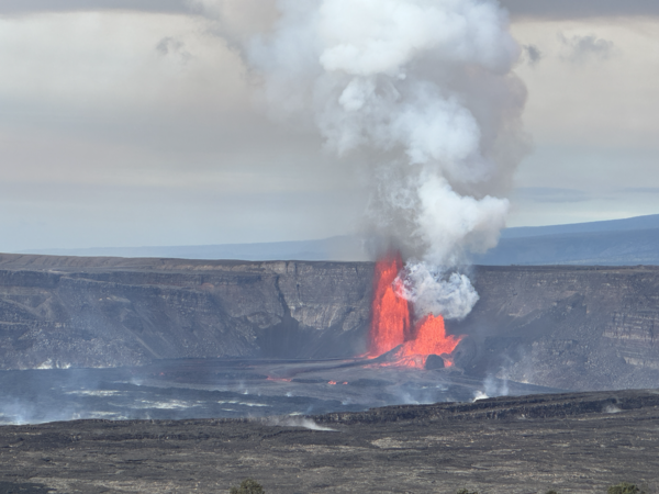
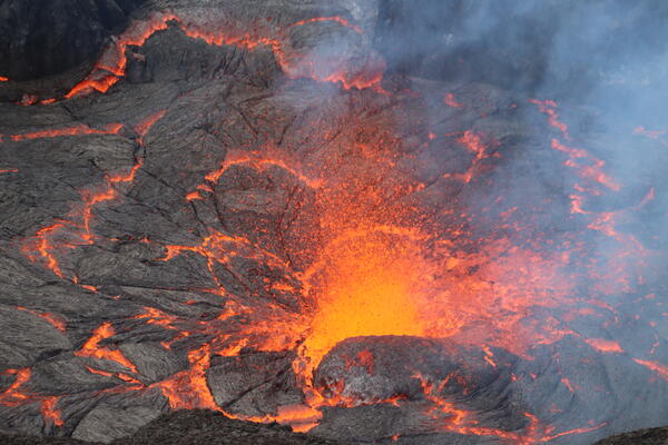
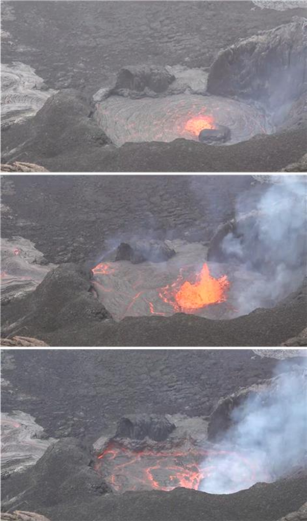
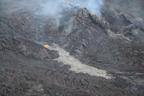
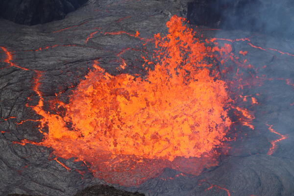
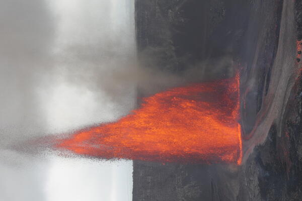
U.S. flag

An official website of the United States government

Images

Kīlauea images of eruptive activity, field work, and more.

Filter Total Items: 2915
Color photograph of volcanic vents degassing
January 24, 2025 — Kīlauea eruption remains on pause during summit overflight and sampling mission

On the morning of January 24th, USGS Hawaiian Volcano Observatory scientists conducted an overflight of Kīlauea summit to capture thermal and surficial imagery of the December 2024 to January 2025 paused eruption.

Color photograph of inactive volcanic vents
January 24, 2025 — Kīlauea summit inactive vents

The north vent that was erupting during episode five of the recent Kīlauea summit eruption has a small patch of lava that was weakly spattering during the morning of January 24, 2025. USGS photo by J. Barnett.

The north vent that was erupting during episode five of the recent Kīlauea summit eruption has a small patch of lava that was weakly spattering during the morning of January 24, 2025. USGS photo by J. Barnett.

Alteration on basalt
January 24, 2025 — Kīlauea summit alteration

During a USGS Hawaiian Volcano Observatory monitoring overflight the morning of January 24, 2025, geologists observed that parts of the recently erupted lava flows are already showing signs of alteration. Fumarolic areas where degassing has occurred are marked by white alteration that has developed on the lava flows that make up the floor of Halema‘uma‘u.

During a USGS Hawaiian Volcano Observatory monitoring overflight the morning of January 24, 2025, geologists observed that parts of the recently erupted lava flows are already showing signs of alteration. Fumarolic areas where degassing has occurred are marked by white alteration that has developed on the lava flows that make up the floor of Halema‘uma‘u.

Color photograph of volcanic vents
January 24, 2025 — Kīlauea caldera floor

USGS Hawaiian Volcano Observatory geologists captured this view across Kaluapele floor, showing the cones that have formed around the recently active north and south vents. USGS photo by J. Barnett. 

USGS Hawaiian Volcano Observatory geologists captured this view across Kaluapele floor, showing the cones that have formed around the recently active north and south vents. USGS photo by J. Barnett. 

Color photograph of erupting vent
January 22, 2025 — Telephoto view of episode 5 lava fountain Kīlauea

This telephoto view of the northern eruptive vent within Halema‘uma‘u crater at the summit of Kīlauea was captured through the lens of a laser rangefinder late in the afternoon on Wednesday, January 22, 2025. USGS Hawaiian Volcano Observatory geologists used the rangefinder to measure lava fountains consistently reaching 100 feet (30 meters) in height.

This telephoto view of the northern eruptive vent within Halema‘uma‘u crater at the summit of Kīlauea was captured through the lens of a laser rangefinder late in the afternoon on Wednesday, January 22, 2025. USGS Hawaiian Volcano Observatory geologists used the rangefinder to measure lava fountains consistently reaching 100 feet (30 meters) in height.

Color photograph of volcanic vents degassing
January 23, 2025 — Kīlauea, Halema‘uma‘u vents on January 23, 2025

Kīlauea'S 2024-2025 eruption resumed around 3 pm HST on January 22, 2025, and ended around 4:30 am HST on January 23, 2025. USGS Hawaiian Volcano Observatory field crews observed the eruptive vents around 9 am on January 23 after the eruption had paused again.

Kīlauea'S 2024-2025 eruption resumed around 3 pm HST on January 22, 2025, and ended around 4:30 am HST on January 23, 2025. USGS Hawaiian Volcano Observatory field crews observed the eruptive vents around 9 am on January 23 after the eruption had paused again.

Color photograph of erupting vent
January 22, 2025 — Kīlauea summit eruption episode 5 lava fountain

In the early evening of Wednesday, January 22, just a few hours into the fifth episode of Kīlauea's summit eruption, USGS Hawaiian Volcano Observatory geologists captured this view of lava fountains at the northern eruptive vent (right) within Halema‘uma‘u crater. The southern eruptive vent (left) was degassing but not actively erupting at the time.

In the early evening of Wednesday, January 22, just a few hours into the fifth episode of Kīlauea's summit eruption, USGS Hawaiian Volcano Observatory geologists captured this view of lava fountains at the northern eruptive vent (right) within Halema‘uma‘u crater. The southern eruptive vent (left) was degassing but not actively erupting at the time.

Color photograph of scientist outline against eruption glow
January 22, 2025 — Silhouette of geologist monitoring episode 5 of Kīlauea summit eruption

A USGS Hawaiian Volcano Observatory geologist's silhouette in front of the illuminated gas plume emanating from Halema‘uma‘u crater on Wednesday, January 22, during the fifth episode of Kīlauea's ongoing summit eruption. USGS photo by M. Zoeller.


A USGS Hawaiian Volcano Observatory geologist's silhouette in front of the illuminated gas plume emanating from Halema‘uma‘u crater on Wednesday, January 22, during the fifth episode of Kīlauea's ongoing summit eruption. USGS photo by M. Zoeller.


Color photograph showing eruption at sunset
January 22, 2025 — Sunset panorama of episode 5, Kīlauea summit

This panorama of Kīlauea summit eruption's fifth episode was captured by USGS Hawaiian Volcano Observatory geologists around sunset on Wednesday, January 22. A tripod camcorder on the crater rim in the foreground was used to record high-resolution video of lava fountains at the northern eruptive vent within Halema‘uma‘u crater. USGS photo by M. Zoeller.

This panorama of Kīlauea summit eruption's fifth episode was captured by USGS Hawaiian Volcano Observatory geologists around sunset on Wednesday, January 22. A tripod camcorder on the crater rim in the foreground was used to record high-resolution video of lava fountains at the northern eruptive vent within Halema‘uma‘u crater. USGS photo by M. Zoeller.

Color photograph of volcanic vent
January 17, 2025 — Close up view of the south vent in Halemaʻumaʻu, Kīlauea

Close up view of the south vent from the southwest rim of Kaluapele, the summit caldera of Kīlauea, on the morning of January 17, 2025. The cone is almost 100 ft (30 m) high and the lava fountain is just as high to slightly high at times. The outlet at the front of the cone is feeding some of the lava flows in the western part of Halemaʻumaʻu. USGS photo by D.

Close up view of the south vent from the southwest rim of Kaluapele, the summit caldera of Kīlauea, on the morning of January 17, 2025. The cone is almost 100 ft (30 m) high and the lava fountain is just as high to slightly high at times. The outlet at the front of the cone is feeding some of the lava flows in the western part of Halemaʻumaʻu. USGS photo by D.

Color photograph of tephra on road
January 17, 2025 — Aerial view of recent tephra across the closed road on Kīlauea

Aerial view of tephra erupted from December 23, 2024, to present (with several pauses) and deposited within the closed area of Hawai‘i Volcanoes National Park. Early in the eruption the lava fountains were ejecting bombs and lapilli across the closed portion of Crater Rim Drive. In places this tephra gets to almost a foot (30 cm) thick. USGS photo by D. Downs.

Aerial view of tephra erupted from December 23, 2024, to present (with several pauses) and deposited within the closed area of Hawai‘i Volcanoes National Park. Early in the eruption the lava fountains were ejecting bombs and lapilli across the closed portion of Crater Rim Drive. In places this tephra gets to almost a foot (30 cm) thick. USGS photo by D. Downs.

Color photograph of eruption in caldera
January 17, 2025 — Kīlauea summit eruption overflight

USGS Hawaiian Volcano Observatory scientists conducted a monitoring overflight of the ongoing summit within Halemaʻumaʻu at the summit of Kīlauea. This aerial view shows the two erupting vents that are located in the southwest part of the caldera. A portion of Crater Rim Drive that collapsed into the caldera in 2018 is visible in the foreground of the photo.

USGS Hawaiian Volcano Observatory scientists conducted a monitoring overflight of the ongoing summit within Halemaʻumaʻu at the summit of Kīlauea. This aerial view shows the two erupting vents that are located in the southwest part of the caldera. A portion of Crater Rim Drive that collapsed into the caldera in 2018 is visible in the foreground of the photo.

Color photograph of scientist monitoring eruption
January 17, 2025 — HVO scientists at work on Kīlauea

Staff from the USGS Hawaiian Volcano Observatory at the rim of Kaluapele (Kīlauea caldera) monitoring and taking measurements of ongoing activity within the summit caldera. USGS photo by K. Mulliken.

Staff from the USGS Hawaiian Volcano Observatory at the rim of Kaluapele (Kīlauea caldera) monitoring and taking measurements of ongoing activity within the summit caldera. USGS photo by K. Mulliken.

Color photograph of Pele's Hair
January 17, 2025 — Pele's Hair from Kīlauea summit eruption

Over the past day, persistent lava fountaining at Kīlauea summit, coupled with Kona wind conditions, has resulted in Pele's hair falling on nearby communities and within parts of Hawaiʻi Volcanoes National Park.

Over the past day, persistent lava fountaining at Kīlauea summit, coupled with Kona wind conditions, has resulted in Pele's hair falling on nearby communities and within parts of Hawaiʻi Volcanoes National Park.

Color photograph of erupting vents
January 17, 2025 — Kīlauea eruption overflight

USGS Hawaiian Volcano Observatory scientists conducted a monitoring overflight of the ongoing summit within Halemaʻumaʻu at the summit of Kīlauea. This low-angle aerial view looking westward shows the two erupting vents that are located in the southwest part of the caldera, and along with the Pāhoehoe lava flowing out of the vents. USGS photo by N. Deligne.

USGS Hawaiian Volcano Observatory scientists conducted a monitoring overflight of the ongoing summit within Halemaʻumaʻu at the summit of Kīlauea. This low-angle aerial view looking westward shows the two erupting vents that are located in the southwest part of the caldera, and along with the Pāhoehoe lava flowing out of the vents. USGS photo by N. Deligne.

Color photograph of eruption plume
January 17, 2025 — Kīlauea summit eruption plume

A view of the nearly vertical eruption plume at Kīlauea summit during the afternoon on January 17, 2025. Photo taken from within the closed area of Hawaiʻi Volcanoes National Park and showing Crater Rim Drive. USGS photo by P. Nadeau. 

A view of the nearly vertical eruption plume at Kīlauea summit during the afternoon on January 17, 2025. Photo taken from within the closed area of Hawaiʻi Volcanoes National Park and showing Crater Rim Drive. USGS photo by P. Nadeau. 

Color photograph of scientists near car operating UAS
January 17, 2025 — Kīlauea summit eruption UAS operations

With permission from Hawaiʻi Volcanoes National Park, USGS Hawaiian Volcano Observatory scientists conducted Uncrewed Aerial Systems (UAS) operations at the Kīlauea summit eruption site on January 17, 2025. Scientists conducted flights to assess volcanic gas emissions and take aerial imagery, which will aid in hazard assessment of the ongoing eruption.

With permission from Hawaiʻi Volcanoes National Park, USGS Hawaiian Volcano Observatory scientists conducted Uncrewed Aerial Systems (UAS) operations at the Kīlauea summit eruption site on January 17, 2025. Scientists conducted flights to assess volcanic gas emissions and take aerial imagery, which will aid in hazard assessment of the ongoing eruption.

Color photograph of erupting vents
January 17, 2025 — UAS photo of spattering eruptive vents in Halema‘uma‘u

On Friday, January 17, USGS Hawaiian Volcano Observatory (HVO) geologists flew an uncrewed aircraft system (UAS, or "drone") into Halema‘uma‘u crater to capture this close-up photo of spattering at the two active vents of the ongoing Kīlauea summit eruption.

On Friday, January 17, USGS Hawaiian Volcano Observatory (HVO) geologists flew an uncrewed aircraft system (UAS, or "drone") into Halema‘uma‘u crater to capture this close-up photo of spattering at the two active vents of the ongoing Kīlauea summit eruption.

Color photograph of erupting vents
January 16, 2025—Telephoto view of Kīlauea summit eruption from Volcano House

Telephoto view of the two vents erupting in the southwest part of Kīlauea summit caldera at approximately 6 a.m. HST. This view is to the southwest, from Volcano House within Hawaiʻi Volcanoes National Park. USGS photo by K. Mulliken. 

Telephoto view of the two vents erupting in the southwest part of Kīlauea summit caldera at approximately 6 a.m. HST. This view is to the southwest, from Volcano House within Hawaiʻi Volcanoes National Park. USGS photo by K. Mulliken. 

Color photograph of erupting vents and small lava flows
January 16, 2025—Kīlauea summit eruption

View of the Kīlauea summit eruption in Hawaiʻi Volcanoes National Park, from the south rim of the caldera. The caldera wall behind the erupting vents is approximately 210 meters (690 feet) tall.

View of the Kīlauea summit eruption in Hawaiʻi Volcanoes National Park, from the south rim of the caldera. The caldera wall behind the erupting vents is approximately 210 meters (690 feet) tall.

Color photograph of two erupting vents and lava flows
January 16, 2025—Telephoto view of Kīlauea summit eruption from Keanakākoʻi Overlook

Telephoto view of the two vents erupting in the southwest part of Halema'uma'u in Kaluapele (Kīlauea summit caldera) at approximately 6 a.m. HST on January 16, 2025. USGS Hawaiian Volcano Observatory geologists in the field this morning measured the lava fountains as reaching approximately 60 meters (197 feet) high.

Telephoto view of the two vents erupting in the southwest part of Halema'uma'u in Kaluapele (Kīlauea summit caldera) at approximately 6 a.m. HST on January 16, 2025. USGS Hawaiian Volcano Observatory geologists in the field this morning measured the lava fountains as reaching approximately 60 meters (197 feet) high.

Was this page helpful?