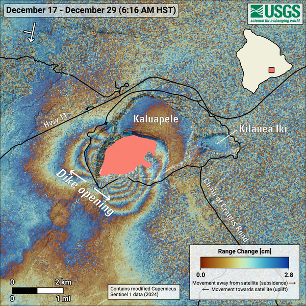
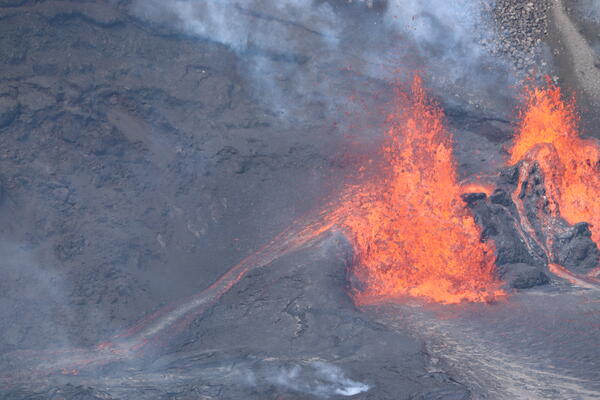
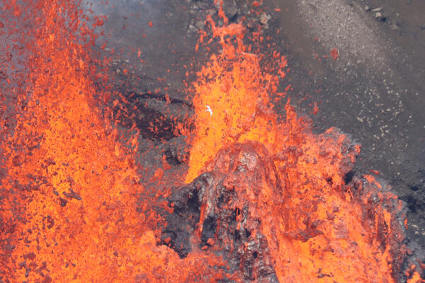
U.S. flag

An official website of the United States government

Images

Kīlauea images of eruptive activity, field work, and more.

Filter Total Items: 2920
Color map of ground temperature in area with ongoing eruption
September 19, 2024 — Thermal map of eruption on Kīlauea East Rift Zone

A helicopter overflight on September 19, 2024, allowed for aerial visual and thermal imagery to be collected at the middle East Rift Zone eruption site on Kīlauea. The eruptive activity continues with a fissure vent active west of Nāpau Crater generating lava flows northeast into the crater.

A helicopter overflight on September 19, 2024, allowed for aerial visual and thermal imagery to be collected at the middle East Rift Zone eruption site on Kīlauea. The eruptive activity continues with a fissure vent active west of Nāpau Crater generating lava flows northeast into the crater.

Color map of lava flows and fissure vents
September 19, 2024 —Kīlauea middle East Rift Zone eruption reference map

This reference map depicts fissures and lava flows from the Kīlauea middle East Rift Zone eruption on Thursday, September 19, 2024. Map data are current as of the Hawaiian Volcano Observatory helicopter overflight that occurred between 9:00 and 10:00 a.m.

This reference map depicts fissures and lava flows from the Kīlauea middle East Rift Zone eruption on Thursday, September 19, 2024. Map data are current as of the Hawaiian Volcano Observatory helicopter overflight that occurred between 9:00 and 10:00 a.m.

Color photograph of newly erupted lava and fume in the background
September 19, 2024—New lava flows on the middle East Rift Zone of Kīlauea

On September 19, 2024, USGS-Hawaiian Volcano Observatory geologists landed near the Kīlauea middle East Rift Zone eruption site, where they viewed lava flowing through a channel more than 50 meters (about 164 feet) wide. USGS photo by M. Zoeller. 

On September 19, 2024, USGS-Hawaiian Volcano Observatory geologists landed near the Kīlauea middle East Rift Zone eruption site, where they viewed lava flowing through a channel more than 50 meters (about 164 feet) wide. USGS photo by M. Zoeller. 

Color photograph of eruption
September 19, 2024 —Kīlauea middle East Rift Zone eruption overflight

During the USGS Hawaiian Volcano Observatory reconnaissance overflight the morning of September 19, geologists observed the fissure west of Nāpau Crater generating a lava flow that travels northeast before cascading into the crater on the remote middle East Rift Zone of Kīlauea. This aerial view is looking in a south direction, from north of the eruption site.

During the USGS Hawaiian Volcano Observatory reconnaissance overflight the morning of September 19, geologists observed the fissure west of Nāpau Crater generating a lava flow that travels northeast before cascading into the crater on the remote middle East Rift Zone of Kīlauea. This aerial view is looking in a south direction, from north of the eruption site.

Molten glowing lava cascades over the rim of a crater after flowing through the jungle from an erupting fissure
September 19, 2024 —Kīlauea middle East Rift Zone eruption overflight

USGS Hawaiian Volcano Observatory geologists conducted a reconnaissance overflight of the eruption near Nāpau Crater on the middle East Rift Zone of Kīlauea. They observed lava cascading over the rim of the crater from a channel more than 50 meters (about 164 feet) wide. Lava is contained within Nāpau Crater and now covers about two thirds of the crater floor.

USGS Hawaiian Volcano Observatory geologists conducted a reconnaissance overflight of the eruption near Nāpau Crater on the middle East Rift Zone of Kīlauea. They observed lava cascading over the rim of the crater from a channel more than 50 meters (about 164 feet) wide. Lava is contained within Nāpau Crater and now covers about two thirds of the crater floor.

Color photograph of lava spatter in the air
September 18, 2024 —lava spattering during the Kīlauea middle East Rift Zone eruption

From the ground in Nāpau Crater, spattering lava was visible above the newly formed lava flows. This eruption is taking place on the remote middle East Rift Zone of Kīlauea, within Hawaiʻi Volcanoes National Park. USGS photo by H. Winslow. 

From the ground in Nāpau Crater, spattering lava was visible above the newly formed lava flows. This eruption is taking place on the remote middle East Rift Zone of Kīlauea, within Hawaiʻi Volcanoes National Park. USGS photo by H. Winslow. 

Color photograph of red molten lava glowing between solidified black crust
September 18, 2024 —lava oozes during the active Kīlauea eruption

Although most of the lava flow field within Nāpau Crater was inactive this morning, lava was actively oozing out of a marginal area. USGS photo by H. Winslow. 

Color photograph of eruption
September 18, 2024 —Kīlauea middle East Rift Zone eruption

During a USGS Hawaiian Volcano Observatory monitoring overflight the morning of September 18, geologists observed only very weak activity at Kīlauea's middle East Rift Zone eruption site in Nāpau Crater.

During a USGS Hawaiian Volcano Observatory monitoring overflight the morning of September 18, geologists observed only very weak activity at Kīlauea's middle East Rift Zone eruption site in Nāpau Crater.

Color photograph of small erupting lava pond
September 18, 2024 —Kīlauea middle East Rift Zone eruption

Weak low fountaining in a tiny lava pond within Nāpau Crater was visible during a morning Hawaiian Volcano Observatory eruption monitoring overflight on September 18, 2024. The eruptive activity has greatly decreased compared to yesterday. USGS photo by H. Winslow. 

Weak low fountaining in a tiny lava pond within Nāpau Crater was visible during a morning Hawaiian Volcano Observatory eruption monitoring overflight on September 18, 2024. The eruptive activity has greatly decreased compared to yesterday. USGS photo by H. Winslow. 

Color photograph of ground surface emitting steam and volcanic gas
September 18, 2024 — Steam and volcanic gas on Kīlauea East Rift Zone

Steam and volcanic gas continue to be emitted from the first fissures that erupted the night of September 15 on the middle East Rift Zone of Kīlauea, west of Nāpau Crater. This photo, taken during morning monitoring overflight, looks southeast. USGS photo by H. Winslow.

Steam and volcanic gas continue to be emitted from the first fissures that erupted the night of September 15 on the middle East Rift Zone of Kīlauea, west of Nāpau Crater. This photo, taken during morning monitoring overflight, looks southeast. USGS photo by H. Winslow.

Color map of lava flows and fissure vents
September 18, 2024 —Kīlauea middle East Rift Zone eruption reference map

This reference map depicts fissures and lava flows from the Kīlauea middle East Rift Zone eruption as of the end of the day on Wednesday, September 18, 2024. Areas in bright red represent new lava flows since the area was last mapped during the morning of September 17, when activity was focused within Nāpau Crater.

This reference map depicts fissures and lava flows from the Kīlauea middle East Rift Zone eruption as of the end of the day on Wednesday, September 18, 2024. Areas in bright red represent new lava flows since the area was last mapped during the morning of September 17, when activity was focused within Nāpau Crater.

Color photograph of glow from volcanic eruption
September 18, 2024—Kīlauea middle East Rift Zone eruption glow visible from Chain of Craters Road

During the evening of September 18, the glow from the middle East Rift Zone eruption of Kīlauea was visible from the Keauhou Trail pull-off within Hawaiʻi Volcanoes National Park. USGS photo by K. Mulliken.

Color map showing the temperature of the ground surface in an area erupting lava
September 18, 2024 — Thermal map of eruption on Kīlauea East Rift Zone

A helicopter overflight on September 18, 2024, allowed for aerial visual and thermal imagery to be collected at the middle East Rift Zone eruption site on Kīlauea. The eruptive activity continues with a single low fountain active within Nāpau Crater and much of the flow field on the crater floor stagnant.

A helicopter overflight on September 18, 2024, allowed for aerial visual and thermal imagery to be collected at the middle East Rift Zone eruption site on Kīlauea. The eruptive activity continues with a single low fountain active within Nāpau Crater and much of the flow field on the crater floor stagnant.

 Helicopter photo a line of steaming fissures cutting through jungle, bisecting an older crater and lava flow.
Degassing fissures from the ongoing middle East Rift Zone eruption at Kīlauea Volcano, September 17, 2024

This photograph of Kīlauea's ongoing middle East Rift Zone eruption was captured during a Hawaiian Volcano Observatory helicopter overflight during the morning of September 17, 2024. Fissures from the previous day's eruption continued to emit steam and gases while new fissures erupted fresh lava in Nāpau Crater. USGS photo by A. Ellis.

This photograph of Kīlauea's ongoing middle East Rift Zone eruption was captured during a Hawaiian Volcano Observatory helicopter overflight during the morning of September 17, 2024. Fissures from the previous day's eruption continued to emit steam and gases while new fissures erupted fresh lava in Nāpau Crater. USGS photo by A. Ellis.

Color photograph of scientist near lava flow
September 17, 2024 —Kīlauea middle East Rift Zone eruption sampling

USGS Hawaiian Volcano Observatory geologists collected a sample of the middle East Rift Zone Kīlauea eruption in Nāpau Crater, within a closed area Hawaiʻi Volcanoes National Park. Geologists put molten lava into a metal bucket and rapidly quench it with water.

USGS Hawaiian Volcano Observatory geologists collected a sample of the middle East Rift Zone Kīlauea eruption in Nāpau Crater, within a closed area Hawaiʻi Volcanoes National Park. Geologists put molten lava into a metal bucket and rapidly quench it with water.

Color photograph of vents erupting lava within a crater
Low-angle view of fissures bisecting Nāpau Crater during the eruption of Kīlauea's middle East Rift Zone, September 17, 2024

This photograph of Kīlauea's ongoing middle East Rift Zone eruption was captured during a Hawaiian Volcano Observatory helicopter overflight during the morning of September 17, 2024. This low-angle view looking southwest shows three lava fountains; the tallest is approximately 10 meters (30 feet) high.

Color map of lava flows and fissure vents
September 17, 2024 —Kīlauea middle East Rift Zone eruption reference map

This reference map depicts fissures and lava flows from the Kīlauea middle East Rift Zone eruption on Tuesday, September 17, 2024. The presented data are current as of the final Hawaiian Volcano Observatory helicopter overflight of the day, which occurred at approximately 10:30 a.m.

This reference map depicts fissures and lava flows from the Kīlauea middle East Rift Zone eruption on Tuesday, September 17, 2024. The presented data are current as of the final Hawaiian Volcano Observatory helicopter overflight of the day, which occurred at approximately 10:30 a.m.

Helicopter photo of a volcanic crater in the midst of a jungle. A line of fissures erupting lava bisects the crater.
Fissures bisecting Nāpau Crater during the eruption of Kīlauea's middle East Rift Zone, September 17, 2024

This photograph of Kīlauea's ongoing middle East Rift Zone eruption was captured during a Hawaiian Volcano Observatory helicopter overflight during the morning of September 17, 2024. Geologists observed fountaining eruptive fissures and active lava flows bisecting the floor of Nāpau Crater, just downrift (northeast) of the September 15 eruptive fissure.

This photograph of Kīlauea's ongoing middle East Rift Zone eruption was captured during a Hawaiian Volcano Observatory helicopter overflight during the morning of September 17, 2024. Geologists observed fountaining eruptive fissures and active lava flows bisecting the floor of Nāpau Crater, just downrift (northeast) of the September 15 eruptive fissure.

Color photograph of volcanic plume
September 17, 2024 —Kīlauea middle East Rift Zone eruption plume

An early morning view of the plume of volcanic gas being emitted by the eruption on Kīlauea’s middle East Rift Zone. This view, from Halapē campground on the coast in Hawaiʻi Volcanoes National Park, shows the plume being transported downwind in a southwest direction.

An early morning view of the plume of volcanic gas being emitted by the eruption on Kīlauea’s middle East Rift Zone. This view, from Halapē campground on the coast in Hawaiʻi Volcanoes National Park, shows the plume being transported downwind in a southwest direction.

Color photograph of volcanic plume
September 17, 2024 —Kīlauea middle East Rift Zone eruption plume

A view under the plume of volcanic gas being transported by wind southwest from the eruption in Nāpau Crater on the middle East Rift Zone of Kīlauea.

Color map showing the ground surface temperature of an area that recently erupted
September 17, 2024 — Thermal map of small eruption on Kīlauea East Rift Zone

A helicopter overflight on September 17, 2024, allowed for aerial visual and thermal imagery to be collected at the middle East Rift Zone eruption site on Kīlauea. The eruptive activity continues with fountains active within Nāpau Crater and lava flowing on the crater floor, marking an eastward shift in activity compared to September 15.

A helicopter overflight on September 17, 2024, allowed for aerial visual and thermal imagery to be collected at the middle East Rift Zone eruption site on Kīlauea. The eruptive activity continues with fountains active within Nāpau Crater and lava flowing on the crater floor, marking an eastward shift in activity compared to September 15.

Was this page helpful?