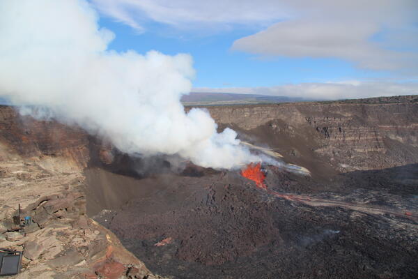
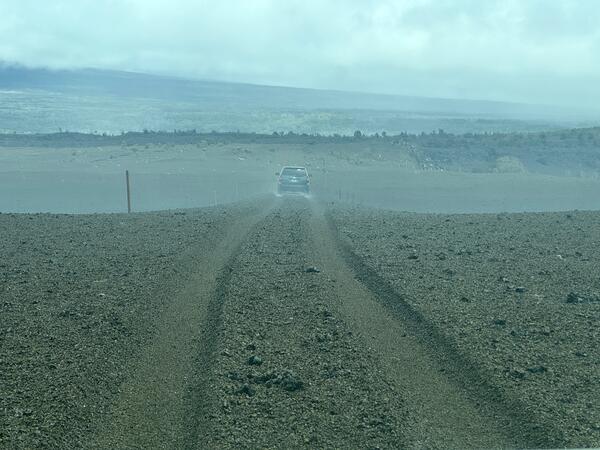
U.S. flag

An official website of the United States government

Images

Kīlauea images of eruptive activity, field work, and more.

Filter Total Items: 3126
Color photograph of active lava
April 9, 2025 — Kīlauea eruption episode 17

Helicopter overflight and a field visit by USGS Hawaiian Volcano Observatory geologists to the crater rim to observe the lava fountaining in episode 17 of the ongoing summit eruption of Kīlauea.

Helicopter overflight and a field visit by USGS Hawaiian Volcano Observatory geologists to the crater rim to observe the lava fountaining in episode 17 of the ongoing summit eruption of Kīlauea.

Color photograph of lava flow
April 9, 2025 — Kīlauea lava flows

During a monitoring overflight at 7:15 a.m. HST on April 9, 2025, USGS Hawaiian Volcano Observatory field crews observed Pāhoehoe flows on the floor of Halema‘uma‘u crater at the summit of Kīlauea. These flows were fed by the south vent fountains, which ceased activity around 9:45 a.m. this morning, April 9, marking the end of episode 17. USGS photo by E.

During a monitoring overflight at 7:15 a.m. HST on April 9, 2025, USGS Hawaiian Volcano Observatory field crews observed Pāhoehoe flows on the floor of Halema‘uma‘u crater at the summit of Kīlauea. These flows were fed by the south vent fountains, which ceased activity around 9:45 a.m. this morning, April 9, marking the end of episode 17. USGS photo by E.

Color photograph of lava flow
April 9, 2025 — Kīlauea lava flow

Lava fountains during episode 17 supplied lava into a broad lava flow field covering much of the Halema‘uma‘u crater floor. Here, a small lobe of pāhoehoe breaks out at the far eastern end of the crater. The lava fountain and its degassing plume are visible in the distance. USGS photo by M. Patrick


Lava fountains during episode 17 supplied lava into a broad lava flow field covering much of the Halema‘uma‘u crater floor. Here, a small lobe of pāhoehoe breaks out at the far eastern end of the crater. The lava fountain and its degassing plume are visible in the distance. USGS photo by M. Patrick


Color photograph of eruption within crater
April 9, 2025 — Kīlauea summit eruption episode 17 overview

A helicopter overflight the morning of April 9, 2025, at 7 a.m. HST provided views of the episode 17 lava fountaining at the summit of Kīlauea just a few hours before it ended. The lava fountains were supplying lava into a flow that covered much of the Halema‘uma‘u crater floor. The fountains also produced a towering outgassing plume above the summit.

A helicopter overflight the morning of April 9, 2025, at 7 a.m. HST provided views of the episode 17 lava fountaining at the summit of Kīlauea just a few hours before it ended. The lava fountains were supplying lava into a flow that covered much of the Halema‘uma‘u crater floor. The fountains also produced a towering outgassing plume above the summit.

Color photograph of scientists examining data on a screen
Visualization of volcanic hazards

A USGS IT Specialist presents a visualization of volcanic hazards derived via satellite radar systems. IT systems facilitating the swift and accurate production of such solutions will be vital to the success of NVEWS. USGS image. 

A USGS IT Specialist presents a visualization of volcanic hazards derived via satellite radar systems. IT systems facilitating the swift and accurate production of such solutions will be vital to the success of NVEWS. USGS image. 

Color photograph of active volcanic vent
April 9, 2025 — Aerial view of the eruptive vents at Kīlauea

During a monitoring overflight on April 9, 2025, USGS Hawaiian Volcano Observatory field crews observed that the ponded lava in the north vent from April 8 had drained and/or collapsed. The south vent was still active, with fountaining sending lava flows across the floor of Halema‘uma‘u. USGS photo by K. Lynn. 

During a monitoring overflight on April 9, 2025, USGS Hawaiian Volcano Observatory field crews observed that the ponded lava in the north vent from April 8 had drained and/or collapsed. The south vent was still active, with fountaining sending lava flows across the floor of Halema‘uma‘u. USGS photo by K. Lynn. 

Color map of lava flows on crater floor
April 9, 2025 — Thermal map of episode 17 lava flow at Kīlauea summit

This thermal map was taken on the 7 a.m. overflight of Kīlauea summit on April 9, 2025, and shows the expansive lava flow covering the floor of Halema‘uma‘u, supplied by lava fountains at the vent. As in earlier episodes, the lava exited the vent into a short channel that fed a broad perched lava pond.

This thermal map was taken on the 7 a.m. overflight of Kīlauea summit on April 9, 2025, and shows the expansive lava flow covering the floor of Halema‘uma‘u, supplied by lava fountains at the vent. As in earlier episodes, the lava exited the vent into a short channel that fed a broad perched lava pond.

Color photograph of scientists monitoring volcanic eruption
April 8, 2025 — Geologists on western rim of Halemaʻumaʻu

In the afternoon of April 8, USGS Hawaiian Volcano Observatory geologists visited the western rim of Halemaʻumaʻu crater to observe the ongoing Kīlauea summit eruption during its seventeenth episode. This telephoto view of the geologists shows them taking laser rangefinder measurements of lava fountains at the active eruptive vent below them within the crater.

In the afternoon of April 8, USGS Hawaiian Volcano Observatory geologists visited the western rim of Halemaʻumaʻu crater to observe the ongoing Kīlauea summit eruption during its seventeenth episode. This telephoto view of the geologists shows them taking laser rangefinder measurements of lava fountains at the active eruptive vent below them within the crater.

Color photograph of volcanic vent erupting
April 8, 2025 — Lava fountain in south vent

Following the onset of the Kīlauea summit eruption's seventeenth episode in the late evening of April 7, USGS Hawaiian Volcano Observatory geologists visited the southern rim of Halemaʻumʻau crater on the morning of April 8 to observe vent activity.

Following the onset of the Kīlauea summit eruption's seventeenth episode in the late evening of April 7, USGS Hawaiian Volcano Observatory geologists visited the southern rim of Halemaʻumʻau crater on the morning of April 8 to observe vent activity.

Color photograph of eruption
April 8, 2025 — Episode 17 of Kīlauea summit eruption

Episode 17 of the ongoing Halemaʻumaʻu eruption at the summit of Kīlauea began last night, April 7, with lava flows erupting from the south vent at 10:15 p.m. HST. Low lava fountaining (100 feet, or 30 meters) was active overnight and continues this afternoon, feeding a lava flow on the crater floor.  USGS photo by M. Zoeller. 

Episode 17 of the ongoing Halemaʻumaʻu eruption at the summit of Kīlauea began last night, April 7, with lava flows erupting from the south vent at 10:15 p.m. HST. Low lava fountaining (100 feet, or 30 meters) was active overnight and continues this afternoon, feeding a lava flow on the crater floor.  USGS photo by M. Zoeller. 

Color photograph of volcanic eruption
April 8, 2025 — Inactive north vent in Halemaʻumaʻu

As the day progressed on April 8, despite continued lava fountaining at the south vent (background right), activity declined at the north vent (foreground left). This afternoon photo captured from the western rim of Halemaʻumaʻu crater—looking to the south—shows the north vent's lava pond fully crusted over and sitting lower within the spatter cone.

As the day progressed on April 8, despite continued lava fountaining at the south vent (background right), activity declined at the north vent (foreground left). This afternoon photo captured from the western rim of Halemaʻumaʻu crater—looking to the south—shows the north vent's lava pond fully crusted over and sitting lower within the spatter cone.

Color maps showing crater floor temperature
April 1 and 2, 2025 — Thermal maps of episode 16 summit activity at Kīlauea

This set of thermal maps shows activity near the beginning and just after the end of episode 16 lava fountaining at the summit of Kīlauea. On April 1, lava fountaining was reaching over 200 meters (660 feet) and was beginning to produce a lava flow covering the western portion of the crater floor.

This set of thermal maps shows activity near the beginning and just after the end of episode 16 lava fountaining at the summit of Kīlauea. On April 1, lava fountaining was reaching over 200 meters (660 feet) and was beginning to produce a lava flow covering the western portion of the crater floor.

Color map of crater floor temperature
April 2, 2025 — Annotated thermal map of Kīlauea summit

This close-up thermal map shows the crater floor at the summit of Kīlauea just an hour after the end of episode 16 lava fountaining on April 2. This map provides a good example of the different zones of lava flow activity on the crater floor that have been observed in many of the eruptive episodes.

This close-up thermal map shows the crater floor at the summit of Kīlauea just an hour after the end of episode 16 lava fountaining on April 2. This map provides a good example of the different zones of lava flow activity on the crater floor that have been observed in many of the eruptive episodes.

Color photograph of caldera
April 2, 2025 — Aerial view of Kaluapele, the caldera at the summit of Kīlauea

Aerial view of Kaluapele, the summit caldera of Kīlauea, hours after the end of episode 16 of the ongoing eruption in Halemaʻumaʻu. USGS photo by K. Lynn. 

Color photograph of crater wall and eruptive vents
April 2, 2025 — Aerial view of eruptive vents and tephra deposit at Kīlauea's summit

USGS Hawaiian Volcano Observatory geologists captured this view during a monitoring overflight just after noon on April 2, 2025, following the end of episode 16 of the ongoing eruption in Halemaʻumaʻu.

Color photograph of active lava
April 2, 2025 — Active lava within Halemaʻumaʻu, Kīlauea's summit

USGS Hawaiian Volcano Observatory geologists landed briefly on the floor of Halemaʻumaʻu crater and captured this image of an active ʻaʻā lava flow. Episode 16 of the ongoing eruption at Kīlaeua summit had ended a couple of hours prior to this photo being taken, and several lava flows retained residual activity at the time of the monitoring overflight.

USGS Hawaiian Volcano Observatory geologists landed briefly on the floor of Halemaʻumaʻu crater and captured this image of an active ʻaʻā lava flow. Episode 16 of the ongoing eruption at Kīlaeua summit had ended a couple of hours prior to this photo being taken, and several lava flows retained residual activity at the time of the monitoring overflight.

Color photograph of caldera
April 2, 2025 — Aerial overview of Kīlauea's summit

During a monitoring flight on April 2, 2025, USGS Hawaiian Volcano Observatory geologists captured this aerial view of Halemaʻumaʻu, within Kaluapele (Kīlauea summit caldera), just after the end of episode 16 of the ongoing eruption.

During a monitoring flight on April 2, 2025, USGS Hawaiian Volcano Observatory geologists captured this aerial view of Halemaʻumaʻu, within Kaluapele (Kīlauea summit caldera), just after the end of episode 16 of the ongoing eruption.

Color photo of geologic deposit
April 2, 2025 — Growing tephra deposit at Kīlauea's summit

During each eruptive episode in Halemaʻumaʻu, tephra is deposited on the crater rim downwind within the closed area of Hawaiʻi Volcanoes National Park. This sign for the Southwest Rift Zone of Kīlauea, which used to stand at least 6 feet (2 meters) above the ground surface, provides a visual for how thick the tephra deposit is at this location. USGS photo by K.

During each eruptive episode in Halemaʻumaʻu, tephra is deposited on the crater rim downwind within the closed area of Hawaiʻi Volcanoes National Park. This sign for the Southwest Rift Zone of Kīlauea, which used to stand at least 6 feet (2 meters) above the ground surface, provides a visual for how thick the tephra deposit is at this location. USGS photo by K.

Color photograph of active lava flows on caldera floor
April 2, 2025 — Aerial view of active lava flows at Kīlauea's summit

Episode 16 of the ongoing eruption in Halemaʻumaʻu stopped just after noon today, April 2, 2025. On a USGS Hawaiian Volcano Observatory monitoring overflight within the hours following its end, the crater floor was a patchwork of active and inactive lava flows.

Episode 16 of the ongoing eruption in Halemaʻumaʻu stopped just after noon today, April 2, 2025. On a USGS Hawaiian Volcano Observatory monitoring overflight within the hours following its end, the crater floor was a patchwork of active and inactive lava flows.

Color photograph of eruption and volcanologist
April 1, 2025 — View lava fountains above crater rim during episode 16 at Kīlauea's summit

On April 1, lava fountains from Kīlauea's ongoing summit eruption prevented geologists from accessing the rim of Halemaʻumaʻu crater within the closed portion of Hawaiʻi Volcanoes National Park. Instead, they hung back along the closed portion of Crater Rim Drive to collect samples of tephra that was intermittently blown in their direction.

On April 1, lava fountains from Kīlauea's ongoing summit eruption prevented geologists from accessing the rim of Halemaʻumaʻu crater within the closed portion of Hawaiʻi Volcanoes National Park. Instead, they hung back along the closed portion of Crater Rim Drive to collect samples of tephra that was intermittently blown in their direction.

Color photograph of volcanic plume
April 1, 2025 — View of the lava fountain during episode 16 at Kīlauea's summit

Episode 16 lava fountains were visible from Highway 11 in Kaʻū on April 1. In this view, the top of the lava fountain is just visible above Halemaʻumaʻu crater rim, and Uēkahuna (the highest part of the caldera rim) is visible to the left. USGS photo by K. Mulliken. 

Episode 16 lava fountains were visible from Highway 11 in Kaʻū on April 1. In this view, the top of the lava fountain is just visible above Halemaʻumaʻu crater rim, and Uēkahuna (the highest part of the caldera rim) is visible to the left. USGS photo by K. Mulliken. 

Was this page helpful?