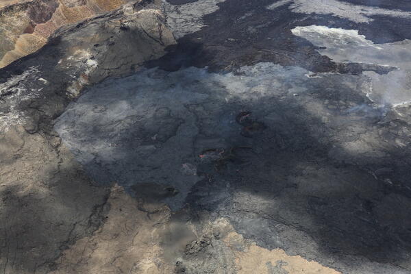
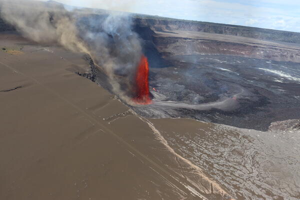
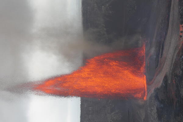
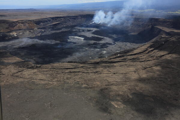
U.S. flag

An official website of the United States government

Images

Kīlauea images of eruptive activity, field work, and more.

Filter Total Items: 2928
Desolate volcanic crater of gray/brown rick under a blue sky with a sloping mountain in the background
Kīlauea summit caldera from B1 camera on December 20, 2024

View of Kaluapele (Kīlauea's summit caldera) from the B1 webcam on December 20, 2024, just before the onset of the episodic lava fountaining eruption on December 23.

View of Kaluapele (Kīlauea's summit caldera) from the B1 webcam on December 20, 2024, just before the onset of the episodic lava fountaining eruption on December 23.

Color photograph of caldera floor
December 3, 2024 — Kīlauea Caldera Floor

While servicing the B1cam, HVO staff captured this telephoto view of the cones that formed on the floor of Kaluapele (Kīlauea summit caldera) during the September 2023 summit eruption. USGS photo by H. Winslow.

While servicing the B1cam, HVO staff captured this telephoto view of the cones that formed on the floor of Kaluapele (Kīlauea summit caldera) during the September 2023 summit eruption. USGS photo by H. Winslow.

Color photograph of scientist examining a webcam on the edge of a caldera
December 3, 2024 — Kīlauea Summit Webcam Maintenance

A HVO geologist inspected the KWcam enclosure for potential water entry points and found a weak seal. HVO staff will likely return in the future to make repairs to the enclosure or replace it all together. USGS photo by J. Barnett.

A HVO geologist inspected the KWcam enclosure for potential water entry points and found a weak seal. HVO staff will likely return in the future to make repairs to the enclosure or replace it all together. USGS photo by J. Barnett.

Color photograph of scientist inspecting webcam on edge of caldera
December 3, 2024 — Kīlauea caldera camera maintenance

HVO staff also visited the B1cam on the western side of Kaluapele (Kīlauea caldera) to remove water, replace desiccant packets, and clean off spider webs on the glass which were beginning to obscure the camera's view. USGS photo by H. Winslow.

HVO staff also visited the B1cam on the western side of Kaluapele (Kīlauea caldera) to remove water, replace desiccant packets, and clean off spider webs on the glass which were beginning to obscure the camera's view. USGS photo by H. Winslow.

Color photograph of scientist examining a webcam on the edge of a caldera
December 3, 2024 — Kīlauea Summit Webcam Maintenance

A HVO geologist inspected the KWcam enclosure for potential water entry points and found a weak seal. HVO staff will likely return in the future to make repairs to the enclosure or replace it all together. USGS photo by J. Barnett.

A HVO geologist inspected the KWcam enclosure for potential water entry points and found a weak seal. HVO staff will likely return in the future to make repairs to the enclosure or replace it all together. USGS photo by J. Barnett.

Color photograph of caldera and webcams perched on rim
December 3, 2024 — Kīlauea Caldera, Kaluapele

The KWcam on the eastern rim of Kaluapele (Kīlauea caldera) has been sending blurry images due water condensation inside the camera enclosure. On December 3rd, 2024, HVO staff visited the webcam to dry out the enclosure and search for any perforations that may be the source of the leak. USGS photo by H. Winslow.

The KWcam on the eastern rim of Kaluapele (Kīlauea caldera) has been sending blurry images due water condensation inside the camera enclosure. On December 3rd, 2024, HVO staff visited the webcam to dry out the enclosure and search for any perforations that may be the source of the leak. USGS photo by H. Winslow.

Color photograph of lava trees
November 25, 2024 — Kīlauea September 2024 Lava Trees

A close-up view of two tree molds beneath the surface of a September 2024 Kīlauea East Rift Zone lava flow. Gas-rich lava flows near the September 2024 fissure vents created void spaces beneath the flow surface, which partially collapsed to reveal the base of these tree molds. USGS photo by L. DeSmither, taken on November 25, 2024.

A close-up view of two tree molds beneath the surface of a September 2024 Kīlauea East Rift Zone lava flow. Gas-rich lava flows near the September 2024 fissure vents created void spaces beneath the flow surface, which partially collapsed to reveal the base of these tree molds. USGS photo by L. DeSmither, taken on November 25, 2024.

Color photograph of burned tree next to hole in lava flow
November 25, 2024 — Kīlauea September 2024 Eruption Tree Mold

A close-up view of a tree mold in a lava flow from the September 2024 Nāpau eruption. When the active lava flow came into contact with the tree, a mold was formed (black hole near center of photo). The high heat of the lava eventually burned through the base of the tree on the right side of the image causing it to fall on top of the newly emplaced lava flow.

A close-up view of a tree mold in a lava flow from the September 2024 Nāpau eruption. When the active lava flow came into contact with the tree, a mold was formed (black hole near center of photo). The high heat of the lava eventually burned through the base of the tree on the right side of the image causing it to fall on top of the newly emplaced lava flow.

Color photograph of scientist taking a cold lava sample
November 25, 2024 — Kīlauea September 2024 Eruption Sample

A USGS Hawaiian Volcano Observatory scientist uses a hammer to collect a sample from a cooled lava flow near the western end of the September 2024 Kīlauea East Rift Zone fissure system. On November 25, Hawaiian Volcano Observatory geologists visited the recent eruption area to collect lava samples and other data to further their studies of the eruption.

A USGS Hawaiian Volcano Observatory scientist uses a hammer to collect a sample from a cooled lava flow near the western end of the September 2024 Kīlauea East Rift Zone fissure system. On November 25, Hawaiian Volcano Observatory geologists visited the recent eruption area to collect lava samples and other data to further their studies of the eruption.

Color photograph of cooled lava draped over crater wall
November 25, 2024 — Kīlauea September 2024 Eruption Lava Falls

On November 25, 2024, USGS Hawaiian Volcano Observatory geologists surveyed the lava-draped west walls of Nāpau Crater. This view looks to the southwest and shows where the lava falls were vigorous enough to throw molten spatter over to the trail area. USGS photo by K. Lynn.

On November 25, 2024, USGS Hawaiian Volcano Observatory geologists surveyed the lava-draped west walls of Nāpau Crater. This view looks to the southwest and shows where the lava falls were vigorous enough to throw molten spatter over to the trail area. USGS photo by K. Lynn.

Color photograph of feature in lava flow with foot for scale
November 25, 2024 — Kīlauea September 2024 Eruption Lava Features

During field work on November 25th, 2024, HVO geologists spotted these lava "rosettes" in Nāpau Crater. They could be found on the edges of the September 15–20 lava flows, and seemed to be twirled up lava margins that spun into flower shapes as the molten flows were viscous and cooling. USGS photo by K. Lynn.

During field work on November 25th, 2024, HVO geologists spotted these lava "rosettes" in Nāpau Crater. They could be found on the edges of the September 15–20 lava flows, and seemed to be twirled up lava margins that spun into flower shapes as the molten flows were viscous and cooling. USGS photo by K. Lynn.

Color photograph of lava draped on tree
November 25, 2024 — Kīlauea September 2024 Eruption Spatter in Trees

Near the western-most fissures from the September 2024 Kīlauea East Rift Zone eruption, lava spatter is visible on the branches of a small ‘ōhi‘a tree. The lava spatter landed while it was still partially molten, causing it drape and stretch over the branches before hardening. USGS photo taken on November 25, 2024, by L. DeSmither.

Near the western-most fissures from the September 2024 Kīlauea East Rift Zone eruption, lava spatter is visible on the branches of a small ‘ōhi‘a tree. The lava spatter landed while it was still partially molten, causing it drape and stretch over the branches before hardening. USGS photo taken on November 25, 2024, by L. DeSmither.

Color photograph of sulphur deposits on tree
November 25, 2024 — Kīlauea September 2024 Eruption Sulfur Deposits

A close-up view of sulfur crystals that have grown on a fallen tree from the September 2024 Kīlauea East Rift Zone eruption. This tree fell over a lava tree cast, which is releasing hot steam and volcanic gas to form this sulfur deposit. USGS photo taken by L. DeSmither on November 25, 2024.

A close-up view of sulfur crystals that have grown on a fallen tree from the September 2024 Kīlauea East Rift Zone eruption. This tree fell over a lava tree cast, which is releasing hot steam and volcanic gas to form this sulfur deposit. USGS photo taken by L. DeSmither on November 25, 2024.

Color photograph of scientist standing in inactive lava channel
November 25, 2024 — Kīlauea September 2024 Eruption Lava Channel

A USGS Hawaiian Volcano Observatory geologist stands in a lava channel from the September 2024 Kīlauea East Rift Zone Eruption and examines the spatter rampart of a fissure on the south side of the channel. Red oxidized blocks from the spatter rampart lay on the floor of the channel in the middle and bottom of the photo. USGS photo taken on November 25, 2024, by L.

A USGS Hawaiian Volcano Observatory geologist stands in a lava channel from the September 2024 Kīlauea East Rift Zone Eruption and examines the spatter rampart of a fissure on the south side of the channel. Red oxidized blocks from the spatter rampart lay on the floor of the channel in the middle and bottom of the photo. USGS photo taken on November 25, 2024, by L.

Color photograph of lava flows on floor of crater
November 25, 2024 — Kīlauea September 2024 Nāpau Crater

With permission from Hawai‘i Volcanoes National Park, team of USGS Hawaiian Volcano Observatory geologists visited the site of the September 2024 Kīlauea middle East Rift Zone eruption. On November 25–26, they surveyed, sampled, and documented the new volcanic fissures and features, which formed west of and in Nāpau crater from September 15–20, 2024.

With permission from Hawai‘i Volcanoes National Park, team of USGS Hawaiian Volcano Observatory geologists visited the site of the September 2024 Kīlauea middle East Rift Zone eruption. On November 25–26, they surveyed, sampled, and documented the new volcanic fissures and features, which formed west of and in Nāpau crater from September 15–20, 2024.

Color photograph of a person's hand with volcanic glass features
November 25, 2024 — Kīlauea September 2024 Eruption Tephra

A USGS Hawaiian Volcano Observatory geologist displays pieces of lava spatter on their hand that were collected for geochemical analyses. The volcanic glass, erupted from a fissure on the East Rift Zone of Kīlauea in September 2024, was twisted in the air while still molten to form unique shapes. USGS photo taken on November 25, 2024, by L. DeSmither.

A USGS Hawaiian Volcano Observatory geologist displays pieces of lava spatter on their hand that were collected for geochemical analyses. The volcanic glass, erupted from a fissure on the East Rift Zone of Kīlauea in September 2024, was twisted in the air while still molten to form unique shapes. USGS photo taken on November 25, 2024, by L. DeSmither.

Color photograph of boot next to volcanic spatter
November 25, 2024 — Kīlauea September 2024 Eruption Spatter

This image shows spatter that was thrown up onto the Nāpau Crater trail to the northeast of the September 2024 middle East Rift Zone lava falls that spilled over the western rim of Nāpau Crater. Boot for scale. USGS photo by K. Lynn.

This image shows spatter that was thrown up onto the Nāpau Crater trail to the northeast of the September 2024 middle East Rift Zone lava falls that spilled over the western rim of Nāpau Crater. Boot for scale. USGS photo by K. Lynn.

Color photograph of scientist standing at edge of cooled lava flow
November 25, 2024 — Kīlauea September 2024 Eruption Lava Flows

A USGS Hawaiian Volcano Observatory geologist observes a fissure from the September 15–20, 2024, Kīlauea East Rift Zone eruption that occurred in and near Nāpau Crater. This photo was taken on November 25, where the first fissure opened, uprift (west) of Nāpau Crater. Pu‘u‘ō‘ō is visible on the skyline in the upper right. USGS photo taken by L. DeSmither.

A USGS Hawaiian Volcano Observatory geologist observes a fissure from the September 15–20, 2024, Kīlauea East Rift Zone eruption that occurred in and near Nāpau Crater. This photo was taken on November 25, where the first fissure opened, uprift (west) of Nāpau Crater. Pu‘u‘ō‘ō is visible on the skyline in the upper right. USGS photo taken by L. DeSmither.

Color photograph of cooled lava flow margin
November 25, 2024 — Kīlauea September 2024 Lava Flow Edge

On November 25, USGS Hawaiian Volcano Observatory geologists visited the site of the September 2024 eruption on Kīlauea’s East Rift Zone. Here, a shelly pāhoehoe lava flow (left) covered the base of a spatter cone (right) that grew around one of the lava fountains from an eruptive fissure vent. USGS photo taken by L. DeSmither. 

On November 25, USGS Hawaiian Volcano Observatory geologists visited the site of the September 2024 eruption on Kīlauea’s East Rift Zone. Here, a shelly pāhoehoe lava flow (left) covered the base of a spatter cone (right) that grew around one of the lava fountains from an eruptive fissure vent. USGS photo taken by L. DeSmither. 

Color map of lava flows
Map showing Kualoloa lava flows originating near the summit of Kīlauea

Map showing Kualoloa lava flows originating near the summit of Kīlauea, with pre- and post-Kualoloa lava flows shown for context. District boundaries and ahupuaʻa borders are also shown, along with placenames mentioned in text.

Map showing Kualoloa lava flows originating near the summit of Kīlauea, with pre- and post-Kualoloa lava flows shown for context. District boundaries and ahupuaʻa borders are also shown, along with placenames mentioned in text.

Color graphic showing two geologic maps side by side
Examples of Hawaii geologic maps

Examples of Hawaii geologic maps. The lefthand map is a USGS Hawaiian Volcano Observatory map created on September 17, 2024, within hours of remote sensing (helicopter overflight) of the eruption that occurred from September 15–20, 2024.

Examples of Hawaii geologic maps. The lefthand map is a USGS Hawaiian Volcano Observatory map created on September 17, 2024, within hours of remote sensing (helicopter overflight) of the eruption that occurred from September 15–20, 2024.

Was this page helpful?