
On Thursday, February 26, USGS Hawaiian Volcano Observatory scientists completed a monitoring helicopter overflight of Halema‘uma‘u crater at the summit of Kīlauea.
Multimedia
Images
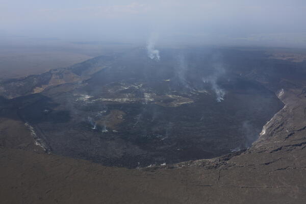
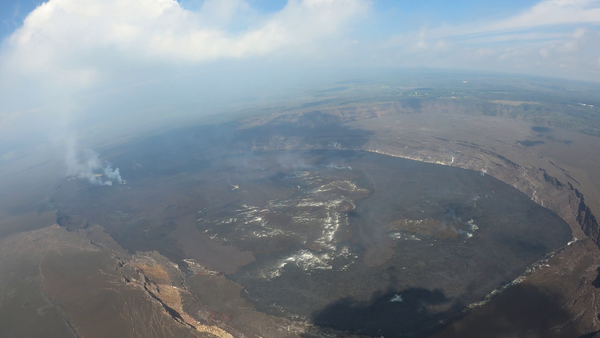
February 26, 2026 — Overview of Halema‘uma‘u
On Thursday, February 26, USGS Hawaiian Volcano Observatory scientists completed a monitoring helicopter overflight of Halema‘uma‘u crater at the summit of Kīlauea.
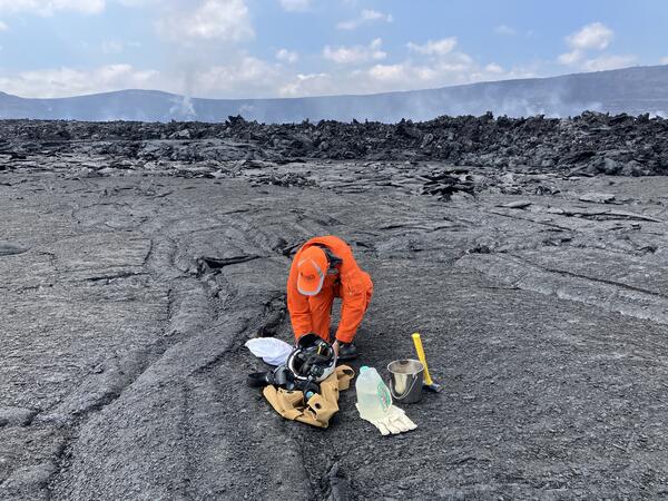
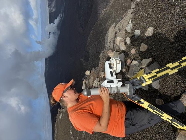
February 26, 2026 — Sampling on Halemaʻumaʻu crater floor, Kīlauea summit
February 26, 2026 — Sampling on Halemaʻumaʻu crater floor, Kīlauea summitAt the end of their Kīlauea summit overflight on Thursday, February 26, two USGS Hawaiian Volcano Observatory geologists were dropped off on the floor of Halema‘uma‘u crater to sample lava from summit eruption episode 42 on February 15.
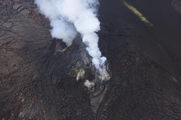
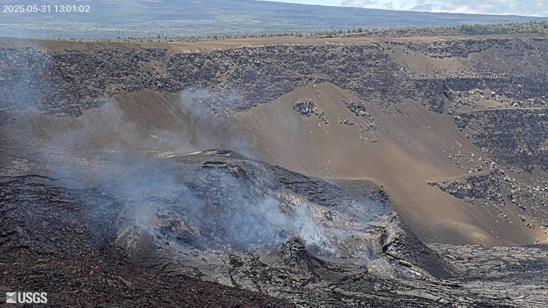
February 26, 2026 — Low pass over eruptive vents at the summit of Kīlauea
February 26, 2026 — Low pass over eruptive vents at the summit of KīlaueaDespite hazy conditions on Thursday, February 26, the USGS Hawaiian Volcano Observatory monitoring overflight crew had clear views of the Kīlauea summit eruptive vents during a low pass over western Halema‘uma‘u crater. No lava or incandescence was visible in either the north (lower-right) or south (upper-left) vent. USGS photo by M. Zoeller.
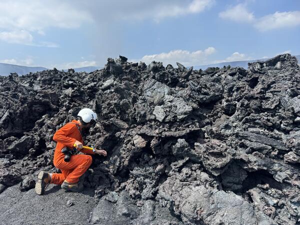
February 26, 2026 — Sampling on Halemaʻumaʻu crater floor, Kīlauea summit
February 26, 2026 — Sampling on Halemaʻumaʻu crater floor, Kīlauea summitA USGS Hawaiian Volcano Observatory geologist collects a cooled lava sample from the front of the episode 42 lava flow on Halema‘uma‘u crater floor at Kīlauea summit. The chemistry of these lava samples is analyzed to better understand the magmatic plumbing system and inform our understanding of eruptive hazards. USGS photo by M. Patrick.
February 26, 2026 — Halemaʻumaʻu overflight, Kīlauea summit
February 26, 2026 — Halemaʻumaʻu overflight, Kīlauea summitUSGS Hawaiian Volcano Observatory (HVO) geologists on a routine KILAUEA summit monitoring helicopter overflight on Thursday, February 26, collected visual and thermal images to map out the changes on the crater floor following episode 42 lava fountaining at KILAUEA summit that took place on February 15, 2026.
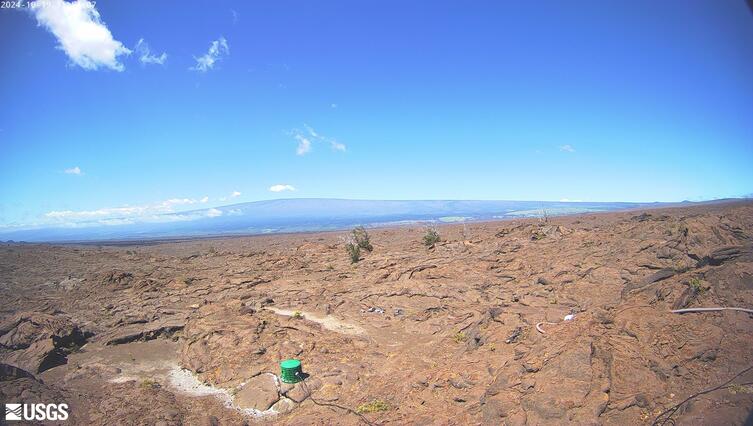
February 26, 2026 — Updating the V3 livestreaming camera, Kīlauea summit
February 26, 2026 — Updating the V3 livestreaming camera, Kīlauea summitOn February 26, 2026, USGS Hawaiian Volcano Observatory staff visited and serviced the V3 livestreaming camera on the south rim of Halemaʻumaʻu crater, at the summit of Kīlauea. USGS photo by M. Patrick.
Videos
February 26, 2026 — Video of Halemaʻumaʻu crater overflight, Kīlauea summit
February 26, 2026 — Video of Halemaʻumaʻu crater overflight, Kīlauea summitUSGS Hawaiian Volcano Observatory (HVO) geologists on a routine Kīlauea summit monitoring helicopter overflight on Thursday, February 26, collected visual and thermal images to map out the changes on the crater floor following episode 42 lava fountaining at Kīlauea summit that took place on February 15, 2026.

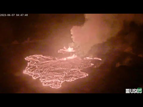
February 15, 2026 — Timelapse video of Kīlauea episode 42 from the KWcam
February 15, 2026 — Timelapse video of Kīlauea episode 42 from the KWcamThe KWcam is located on the northwest rim of Halemaʻumaʻu crater at the summit of Kīlauea. The camera is one of many located around the Kaluapele, Kīlauea summit caldera, that aid in monitoring conditions. This timelapse video was created using images captured by the KWcam on February 15, 2026, during episode 42 of lava fountaining. Around 4:20 p.m.

January 24-25, 2026 — Kīlauea episode 41 tephra fall covers Uēkahuna Overlook Hawaiʻi Volcanoes National Park and then is cleaned up
January 24-25, 2026 — Kīlauea episode 41 tephra fall covers Uēkahuna Overlook Hawaiʻi Volcanoes National Park and then is cleaned upTimelapse video showing tephra cover to cleanup in Hawaiʻi Volcanoes National Park. Lava fountains during episode 41 of the Kīlauea summit eruption on January 24, 2026, covered the Uēkahuna overlook within Hawaiʻi Volcanoes National Park with tephra fallout. The next morning, Hawaiʻi Volcanoes National Park staff clean the tephra from the area.

January 24, 2026 — Kīlauea episode 41 timelapse video
January 24, 2026 — Kīlauea episode 41 timelapse videoThis timelapse video shows Kīlauea summit eruption episode 41 on January 24, 2026, captured by a USGS Hawaiian Volcano Observatory research camera on the south rim of the caldera. Both the north and south vents erupted,and the black material in the foreground is falling tephra. USGS video.

December 23, 2025 — Kīlauea episode 39 VIDEO
Kīlauea began its 39th lava fountaining episode the night of December 23, one year to the day from when this eruption began. This view was taken from the publicly accessible viewing area on Crater Rim Drive near Keanakākoi Overlook within Hawaiʻi Volcanoes National Park.
Kīlauea began its 39th lava fountaining episode the night of December 23, one year to the day from when this eruption began. This view was taken from the publicly accessible viewing area on Crater Rim Drive near Keanakākoi Overlook within Hawaiʻi Volcanoes National Park.

December 9, 2025—Aerial video of Halemaʻumaʻu crater after episode 38
December 9, 2025—Aerial video of Halemaʻumaʻu crater after episode 38On December 9, USGS-Hawaiian Volcano Observatory geologists conducted an aerial overflight of Kīlauea summit region, following lava fountaining episode 38 of the Halemaʻumaʻu eruption on December 6. In this video, the line on the ground in the lower left portion at the start of the video shows the extent of tephra deposits created during episode 38.
Audio

Lava lake activity from inside Halema`uma`u Crater
Lava lake activity from inside Halema`uma`u CraterSounds of lava lake activity within Kilauea Volcano's summit vent inside Halema`uma`u Crater on the afternoon of February 14, 2011. The continuous "crashing wave" noise is the sound of churning lava as gases are released from the lake surface, which is in nearly constant motion.

Dramatic Developments at Kilauea Volcano
Kilauea Volcano in Hawaii has experienced its first explosive eruption in more than 80 years and is now spewing noxious gas at 10 times the normal rate. John Eichelberger, head of the USGS Volcano Hazards Program, fills us in on the situation.
Kilauea Volcano in Hawaii has experienced its first explosive eruption in more than 80 years and is now spewing noxious gas at 10 times the normal rate. John Eichelberger, head of the USGS Volcano Hazards Program, fills us in on the situation.
Webcams
[V3cam] Kīlauea volcano, Hawaii (south Halemaʻumaʻu crater)
[V3cam] Kīlauea volcano, Hawaii (south Halemaʻumaʻu crater)Last 24 Hours - Live view of Halemaʻumaʻu crater within Kaluapele (Kīlauea caldera), from the south rim of the crater [V3cam]. This camera is a pan-tilt-zoom model and the view may change depending on activity.
Disclaimer
[V2cam] Kīlauea volcano, Hawaii (east Halemaʻumaʻu crater)
[V2cam] Kīlauea volcano, Hawaii (east Halemaʻumaʻu crater)Live view of Kaluapele (Kīlauea caldera) and Halemaʻumaʻu crater, from the northeast rim of the caldera [V2cam]. This camera is a pan-tilt-zoom model and the view may change depending on activity.
Disclaimer

[KOcam] Live Image of upper East Rift Zone from Maunaulu
[KOcam] Live Image of upper East Rift Zone from MaunauluThis image is from a temporary research camera positioned near Maunaulu, looking northwest toward the upper East Rift Zone of Kīlauea.
Disclaimer
[KOcam] Live Image of upper East Rift Zone from Maunaulu
[KOcam] Live Image of upper East Rift Zone from MaunauluThis image is from a temporary research camera positioned near Maunaulu, looking northwest toward the upper East Rift Zone of Kīlauea.
Disclaimer
[MITDcam] Kīlauea upper Southwest Rift Zone
[MITDcam] Live view of Kīlauea's upper Southwest Rift Zone, looking northwest from a seismic station in the Kaʻū Desert.
[MITDcam] Live view of Kīlauea's upper Southwest Rift Zone, looking northwest from a seismic station in the Kaʻū Desert.
Kīlauea Volcano Live Stream - Halemaʻumaʻu crater
Live view of the eruption in Halemaʻumaʻu, from the northwest rim of the caldera, looking east [V1cam] on the USGS YouTube Channel.
Live view of the eruption in Halemaʻumaʻu, from the northwest rim of the caldera, looking east [V1cam] on the USGS YouTube Channel.

[V1cam] Kīlauea volcano, Hawaii (west Halemaʻumaʻu crater)
[V1cam] Kīlauea volcano, Hawaii (west Halemaʻumaʻu crater)Live view of Halemaʻumaʻu crater within Kaluapele (Kīlauea caldera), from the northwest rim of the crater [V1cam]. This camera is a pan-tilt-zoom model and the view may change depending on activity.
Disclaimer