U.S. flag

An official website of the United States government

Images

Images related to Lassen Volcanic Center.

Filter Total Items: 25
In this photo of a bare, rocky hill in the middle of a fire-blackened forest, a pole and strapping are laying on the ground next to a charred stump. In the foreground, a dented and warped box contains the melted remains of several large bits of electronics. USGS photo by Ryan Presser, NCSN.
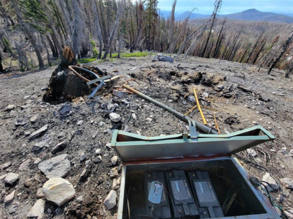
Fire-damaged seismic station in the Lassen Volcanic Center

This seismic station in the Lassen Volcanic Center was damaged during the Dixie Fire of 2021, which burned huge swathes of forest in the Lassen Volcanic National Park. Above-ground equipment, including the tree that held the antenna and solar panel above winter snows, was destroyed; belowground seismic sensors were recoverable. USGS photo by Ryan Presser, NCSN.

This seismic station in the Lassen Volcanic Center was damaged during the Dixie Fire of 2021, which burned huge swathes of forest in the Lassen Volcanic National Park. Above-ground equipment, including the tree that held the antenna and solar panel above winter snows, was destroyed; belowground seismic sensors were recoverable. USGS photo by Ryan Presser, NCSN.

Shaded relief map showing Lassen Volcanic National Park, with Lassen Peak labeled in the northern portion of the map, Growler & Morgan hot springs to the southwest, and the June 24 2024 swarm to the southeast
Lassen Volcanic Center earthquake swarm of June 24, 2024

This map shows the location of the June 24, 2024 earthquake swarm at the Lassen Volcanic Center relative to Lassen Peak and Growler & Morgan Hot Springs. Earthquakes are indicated by white, blue, and yellow circles, scaled to the earthquake size.

This map shows the location of the June 24, 2024 earthquake swarm at the Lassen Volcanic Center relative to Lassen Peak and Growler & Morgan Hot Springs. Earthquakes are indicated by white, blue, and yellow circles, scaled to the earthquake size.

Helicorder record showing dozens of tiny earthquake traces occurring over 12 hours, with each line comprising 15 minutes and earthquakes looking like drum cymbals turned on their sides.
LSIB helicorder trace from the Lassen Volcanic Center on June 24, 2024.

This digital helicorder record from station LSIB on the Northern California Seismic Network emphasizes the dozens of tiny earthquakes in Lassen's June 24 swarm. Earch line of the helicorder shows 15 minutes of time, with the entire record covering 24 hours.

This digital helicorder record from station LSIB on the Northern California Seismic Network emphasizes the dozens of tiny earthquakes in Lassen's June 24 swarm. Earch line of the helicorder shows 15 minutes of time, with the entire record covering 24 hours.

A steaming hot spring and stream flow through the yellow-and-white altered rock of a hydrothermal area. A raised walkway is visible in the background.
Devil's Kitchen hydrothermal area in the Lassen Volcanic Center

Devils Kitchen in the Lassen Volcanic Region (within the bounds of the Lassen Volcanic National Park) is the second largest of Lassen's hydrothermal areas, after Bumpass Hell. Located in the Warner Valley in the southeast corner of the Park, Devils Kitchen contains boiling springs, mudpots, hot streams, and steam vents. USGS photo courtesy of Deb Bergfeld

Devils Kitchen in the Lassen Volcanic Region (within the bounds of the Lassen Volcanic National Park) is the second largest of Lassen's hydrothermal areas, after Bumpass Hell. Located in the Warner Valley in the southeast corner of the Park, Devils Kitchen contains boiling springs, mudpots, hot streams, and steam vents. USGS photo courtesy of Deb Bergfeld

Lassen Volcanic Center, California simplified hazards map showing p...
Lassen Volcanic Center, CA simplified hazards map

Lassen Volcanic Center, California simplified hazards map showing potential impact area for ground-based hazards during a volcanic event.

Map showing one-year probability of accumulation of 1 centimeter
Volcano hazard zone map for Lassen Volcanic Region in Northern Cali...
Volcano hazard zone map for Lassen Volcanic Region in Northern CA p...

Volcanic Hazard Assessment for the Lassen Region, California is based upon a comprehensive investigation of the eruptive history and possible future eruption scenarios with associated volcanic hazards.

Chaos Crags in Lassen Volcanic National Park

Chaos Jumbles (foreground) is a rockfall avalanche that formed around 340 years ago when one of the Chaos Crags domes (background) collapsed.

Chaos Jumbles (foreground) is a rockfall avalanche that formed around 340 years ago when one of the Chaos Crags domes (background) collapsed.

Cinder Cone in Lassen Volcanic National Park

Cinder Cone erupted in the year 1666 in the Lassen Volcanic Region of northern California.

In a black-and-white photo, a small wooden cabin with a peaked roof and single door and window sits in a snowy forest clearing. Snow is piled to chest height around the building and blobs of snow cling to the peak of the roof.
Lassen Volcano Observatory, 1926

The original Lassen Volcano Observatory building, provided by the US Forest Service, about 1926. The observatory consisted of a small office over a 10x10 ft concrete cellar which housed two custom-built seismographs. A small cottage nearby housed Ruy H. Finch, the head of and sole scientist at the Observatory for much of its existence. (Photo by R.H.

The original Lassen Volcano Observatory building, provided by the US Forest Service, about 1926. The observatory consisted of a small office over a 10x10 ft concrete cellar which housed two custom-built seismographs. A small cottage nearby housed Ruy H. Finch, the head of and sole scientist at the Observatory for much of its existence. (Photo by R.H.

A black-and-white photo of a man in a black suit jacket, pinstriped pants, and a dapper fedora. He is standing on a Hawaiian pahoehoe lava flow and peering into a deep ground crack.
Ruy H. Finch (1890-1957)

The founder of the Lassen Volcano Observatory (1926-1935) and second Director of the Hawaiian Volcano Observatory (1940-1951), Ruy Herbert Finch conducted research in both Hawaii and throughout the Western United States.

The founder of the Lassen Volcano Observatory (1926-1935) and second Director of the Hawaiian Volcano Observatory (1940-1951), Ruy Herbert Finch conducted research in both Hawaii and throughout the Western United States.

In a black-and-white photo, a snow-covered mountain peak is streaked with dark mud flowing down its sides in three directions. One flow directly faces the viewer, showing where trees have been mowed over by the debris. Elsewhere on the slopes, pine trees are scattered through the snow.
Lava and mudflows from Lassen Peak, May 22, 1915

Benjamin F. Loomis Historical Photograph Collection: Lassen Peak showing new lava flow on summit and large mudflows on slopes. Photo courtesy of NPS.

Benjamin F. Loomis Historical Photograph Collection: Lassen Peak showing new lava flow on summit and large mudflows on slopes. Photo courtesy of NPS.

Was this page helpful?