



Some of the 24 overlapping lava domes that make up Mammoth Mountain are visible in this 3D geologic map. Many of the domes are made of dacite ("dsd", "dwr") and rhyolite lava ("rss", "rsq"), and are surrounded by smooth surface deposits of pumice and sedimentary material.
Multimedia
Images
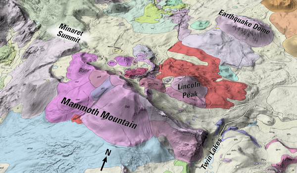
3D geologic map of Mammoth Mountain, California
Some of the 24 overlapping lava domes that make up Mammoth Mountain are visible in this 3D geologic map. Many of the domes are made of dacite ("dsd", "dwr") and rhyolite lava ("rss", "rsq"), and are surrounded by smooth surface deposits of pumice and sedimentary material.
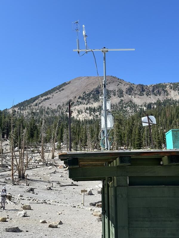
Eddy covariance monitoring station at Horseshoe Lake, Mammoth Mountain, California
Eddy covariance monitoring station at Horseshoe Lake, Mammoth Mountain, CaliforniaThe eddy covariance station shown in this photo has been continuously measuring CO₂ emissions since 2014, providing half-hourly measurements of volcanic gas flux. Unlike previous seasonal monitoring that was limited by snowpack, this 6-meter-tall tower setup with commercial power allows year-round operation - a first for volcanic gas monitoring in this environment.

Mammoth Mountain
View of the Mammoth Mountain lava dome complex overlooking Horseshoe Lake.
View of the Mammoth Mountain lava dome complex overlooking Horseshoe Lake.

Eddy covariance station at Mammoth Mountain, California
Eddy covariance station at Mammoth Mountain, CaliforniaPhotograph of permanent eddy covariance station installed since 2014 in area of volcanic CO2 emissions on Mammoth Mountain, California. USGS photo by Jennifer Lewicki, August 2019.
Eddy covariance station at Mammoth Mountain, California
Eddy covariance station at Mammoth Mountain, CaliforniaPhotograph of permanent eddy covariance station installed since 2014 in area of volcanic CO2 emissions on Mammoth Mountain, California. USGS photo by Jennifer Lewicki, August 2019.

Model of reservoirs underneath Long Valley Caldera
Model of reservoirs underneath Long Valley CalderaMain hydrothermal features of the new (2016) 3-D model of the subsurface at Long Valley Caldera. This schematic is based on a survey of the electrical properties of the earth (magnetotellurics) below. Arrows show subsurface water flow, with colors keyed to changing water temperature, from blue (cold) to red (hot). Purple arrows show an extinct hot water pathway.

Volcanic-gas "sniffer" installed at Mammoth Mountain, CA measures t...
Volcanic-gas "sniffer" installed at Mammoth Mountain, CA measures t...Volcanic-gas "sniffer" installed at Mammoth Mountain, California measures temperature plus carbon dioxide and other gas concentration from a steaming vent.
Volcanic-gas "sniffer" installed at Mammoth Mountain, CA measures t...
Volcanic-gas "sniffer" installed at Mammoth Mountain, CA measures t...Volcanic-gas "sniffer" installed at Mammoth Mountain, California measures temperature plus carbon dioxide and other gas concentration from a steaming vent.