U.S. flag

An official website of the United States government

Images

Images related to Mammoth Mountain.

A deep blue lake is nestled in pine forest at the foot of a rocky, hilly peak
Mammoth Mountain
Mammoth Mountain
Mammoth Mountain

View of the Mammoth Mountain lava dome complex overlooking Horseshoe Lake.

View of the Mammoth Mountain lava dome complex overlooking Horseshoe Lake.

Eddy covariance station at Mammoth Mountain, California

Photograph of permanent eddy covariance station installed since 2014 in area of volcanic CO2 emissions on Mammoth Mountain, California. USGS photo by Jennifer Lewicki, August 2019.

Photograph of permanent eddy covariance station installed since 2014 in area of volcanic CO2 emissions on Mammoth Mountain, California. USGS photo by Jennifer Lewicki, August 2019.

Model of reservoirs underneath Long Valley Caldera...
Model of reservoirs underneath Long Valley Caldera

Main hydrothermal features of the new (2016) 3-D model of the subsurface at Long Valley Caldera. This schematic is based on a survey of the electrical properties of the earth (magnetotellurics) below. Arrows show subsurface water flow, with colors keyed to changing water temperature, from blue (cold) to red (hot). Purple arrows show an extinct hot water pathway.

Main hydrothermal features of the new (2016) 3-D model of the subsurface at Long Valley Caldera. This schematic is based on a survey of the electrical properties of the earth (magnetotellurics) below. Arrows show subsurface water flow, with colors keyed to changing water temperature, from blue (cold) to red (hot). Purple arrows show an extinct hot water pathway.

Volcanic-gas "sniffer" installed at Mammoth Mountain, California me...
Volcanic-gas "sniffer" installed at Mammoth Mountain, CA measures t...

Volcanic-gas "sniffer" installed at Mammoth Mountain, California measures temperature plus carbon dioxide and other gas concentration from a steaming vent.

Volcanic-gas "sniffer" installed at Mammoth Mountain, California measures temperature plus carbon dioxide and other gas concentration from a steaming vent.

Carbon dioxide gas detection instrument installed at Horseshoe Lake...
Carbon dioxide gas detection Horseshoe Lake, Mammoth Mountain, CA.

Carbon dioxide gas detection instrument installed at Horseshoe Lake, Mammoth Mountain, California.
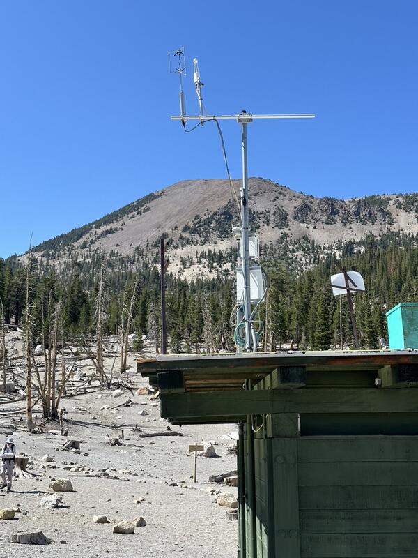
Hydrothermal system and water flow in the subsurface beneath Long V...

Hydrothermal system and water flow in the subsurface beneath Long Valley Caldera, California. Cartoon Illustration from USGS FS 2007-3045.

Graphic depicting the distribution of Yellowstone ash across the U....
Map of volcanic ash fall as a result of eruptions from Yellowstone,...

Map of volcanic ashfall. Areas of the United States that once were covered by volcanic ash from Yellowstone's giant eruptions 2 million and 630,000 years ago, compared with ashfall from the 760,000-year-old Long Valley caldera eruptions at Mammoth Lakes, California, and the 1980 eruption of Mount St. Helens, Washington.

Map of volcanic ashfall. Areas of the United States that once were covered by volcanic ash from Yellowstone's giant eruptions 2 million and 630,000 years ago, compared with ashfall from the 760,000-year-old Long Valley caldera eruptions at Mammoth Lakes, California, and the 1980 eruption of Mount St. Helens, Washington.

View of the Mono Lake-Long Valley volcanic region

An aerial view looking south of the Long Valley volcanic region in the area of Mono Lake, showing a line of rhyolite lava domes and explosion craters. An inset map shows the locations of silcic magmatic centers in the Long Valley area.

An aerial view looking south of the Long Valley volcanic region in the area of Mono Lake, showing a line of rhyolite lava domes and explosion craters. An inset map shows the locations of silcic magmatic centers in the Long Valley area.