
The 1984 eruption of Mauna Loa ended a 9-year period of quiescence.
Eruption Precursors: Earthquakes & Deformation 1975-1984

The eruption began suddenly, following a 3-year period of slowly increasing earthquake activity beneath the volcano that included a swarm of earthquakes 5 to 13 km (3 to 9 mi) deep in mid-September 1983. The earthquakes reached a maximum frequency just after a 6.6-magnitude earthquake took place beneath the southeast flank of Mauna Loa, in the Ka‘ōiki fault system, on November 16, 1983. Following the Ka‘ōiki earthquake, the number of earthquakes >M 1.5 increased gradually as the time of eruption approached.
Repeated deformation measurements showed that the summit area of the volcano began to inflate shortly after the brief summit eruption on July 5-6, 1975. Inflation continued to the time of the 1984 eruption.
The immediate precursors to the eruption consisted of an abrupt increase in small earthquakes and volcanic tremor recorded on seismic stations located near Moku‘āweoweo. At 10:55 p.m. on March 24, small earthquakes began at a rate of 2-3 per minute. By 11:30 p.m., the seismic background increased, marking the onset of tremor. Just before 1:00 a.m. on March 25, the tremor amplitude increased to the point that the astronomical telescopes on Mauna Kea, 42 km (26 mi) to the northwest, could not be stabilized because of the constant ground vibration.

Eruption Begins in Moku‘āweoweo Caldera —March 25, 1:30 a.m. HST
At 1:25 a.m., a military satellite recorded a strong infrared signal from the summit of Mauna Loa, indicating that the eruption was underway. Within just a few minutes, people all over Hawai‘i Island were reporting an intense red glow above the volcano.
The eruptive fissures migrated rapidly down the southwest rift zone to the 3,886 m (12,750 ft) elevation and across the southern half of Moku‘āweoweo (flow A on map). By 4:00 a.m., lava fountains extended across the northeast half of Moku‘āweoweo and into the upper reaches of the northeast rift zone (flow B on map).
New Lava Fissures Form as Magma Moves Down Northeast Rift Zone — March 25, 03:57 a.m. to 4:00 p.m. HST
At 10:30 a.m., intense steam emissions began along a fracture 1 km (0.6 mi) long farther down the northeast rift zone between the 3,258- and 3,170-m elevation (10,690 and 10,400 ft), but no eruptive fissure formed in this area. By mid-afternoon, eruptive activity began to decrease at the uppermost vents between 3,700- and 3,780-m.
New Fissure Becomes Eruption's Main Vent — March 25, 4:41 p.m.
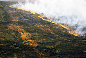
At 4:41 p.m., a new fissure opened up at the 2,850 m elevation (9,350 ft). This fissure rapidly migrated both uprift and downrift, so that by 6:30 p.m., a line of fountains slightly longer than 1.6 km (1 mi) was active. Eventually the fissure system condensed to four centers of activity with fountains up to 50 m (165 ft) high. Four parallel flows (flows D on map) moved down the northeast flank at speeds as fast as 90 to 215 m per hour (300 to 700 ft per hour.)

All vents uprift from these new ones quickly became inactive, and the eruptive activity was confined to these vents for the next three weeks. Six large vent structures eventually formed in this area around the active vents.

Lava Advances Toward Hilo — March 26 - 29
By daybreak on March 26, these ventswere feeding lava to a fast-moving flow (flow E on map) that had advanced 9 km (5.5 mi) to the northeast and three less active, shorter flows (flows D on map) that were advancing east toward Kulani Prison. The prison was put on alert, because the shorter lava flows were as close as 3.2 km (2 mi) to the prison. These flows, however, stopped advancing within 48 hours and never crossed the Powerline Road.
The fast-moving flow (flow E on map) advanced as a relatively narrow, channelized ‘a‘ā lava flow. Its rate of advance slowed as it moved downslope, but by March 29 the flow had moved 29 km (15.5 mi) to an elevation of 915 m (3,000 ft). At this time, the flow front was about 6.5 km (4 mi) from the outskirts of Hilo. Smoke from burning vegetation, loud explosions caused by methane gas along the advancing flow front, and the intense glow at night all contributed to a growing concern among Hilo's residents. Would the lava reach the city?
Lava Breaks Out of Channel, Forms New Flow — March 29, a.m.
Early in the morning, a levee along the lava channel broke at the 1,737 m elevation (5,700 ft) about 13 km (8 mi) upslope from the flow front (flow E on map). The lava was diverted into a new subparallel flow (flow F on map) and flow E stagnated, temporarily relieving emergency-response officials and residents of Hilo. This new ‘a‘ā lava flow moved at a comparable rate to the earlier flow E, yet did not extend beyond flow E until April 4.

More Levees Break & Rate of Eruption Slows — March 29 - April 14
Another significant levee breakout occurred on April 5, forming a third subparallel ‘a‘ā lava flow (flow G on map) that moved downslope. Concurrently, lava output at the source ventsdiminished slightly, and the lava became more viscous, resulting in channel blockages and levee collapses that occurred more frequently. The collapses restricted the supply of lava to the flow fronts, which moved steadily higher and more distant from the outskirts of Hilo. By April 14, no active ‘a‘ā lava flows extended more than 2 km (1.25 mi) from the vents, and on April 15, the eruption ended.
Valuable lessons learned that will help in future Mauna Loa eruptions
The natural breakdown of levees along the margins of the channelized ‘a‘ā flows diverted lava from the main channel into one or more new subparallel flows. Consequently, the advance of the main flow was arrested. Many factors facilitated this diversion, including (1) relatively gentle slopes; (2) dense vegetation through which the flows moved; (3) the relatively low temperature of the erupted lava, which made it relatively viscous; and (4) the gradual decline of eruption rates. These factors and the short duration of the eruption helped to prevent lava from advancing into Hilo.
This experience may help us to determine whether future lava flows erupted by Mauna Loa are likely to continue advancing down gentle slopes or whether lava will break out of a well-defined channel into a new flow.
See the table summarizing Mauna Loa activity over the past ~200 years here.
The 1984 eruption of Mauna Loa ended a 9-year period of quiescence.
Eruption Precursors: Earthquakes & Deformation 1975-1984
The eruption began suddenly, following a 3-year period of slowly increasing earthquake activity beneath the volcano that included a swarm of earthquakes 5 to 13 km (3 to 9 mi) deep in mid-September 1983. The earthquakes reached a maximum frequency just after a 6.6-magnitude earthquake took place beneath the southeast flank of Mauna Loa, in the Ka‘ōiki fault system, on November 16, 1983. Following the Ka‘ōiki earthquake, the number of earthquakes >M 1.5 increased gradually as the time of eruption approached.
Repeated deformation measurements showed that the summit area of the volcano began to inflate shortly after the brief summit eruption on July 5-6, 1975. Inflation continued to the time of the 1984 eruption.
The immediate precursors to the eruption consisted of an abrupt increase in small earthquakes and volcanic tremor recorded on seismic stations located near Moku‘āweoweo. At 10:55 p.m. on March 24, small earthquakes began at a rate of 2-3 per minute. By 11:30 p.m., the seismic background increased, marking the onset of tremor. Just before 1:00 a.m. on March 25, the tremor amplitude increased to the point that the astronomical telescopes on Mauna Kea, 42 km (26 mi) to the northwest, could not be stabilized because of the constant ground vibration.
Eruption Begins in Moku‘āweoweo Caldera —March 25, 1:30 a.m. HST
At 1:25 a.m., a military satellite recorded a strong infrared signal from the summit of Mauna Loa, indicating that the eruption was underway. Within just a few minutes, people all over Hawai‘i Island were reporting an intense red glow above the volcano.
The eruptive fissures migrated rapidly down the southwest rift zone to the 3,886 m (12,750 ft) elevation and across the southern half of Moku‘āweoweo (flow A on map). By 4:00 a.m., lava fountains extended across the northeast half of Moku‘āweoweo and into the upper reaches of the northeast rift zone (flow B on map).
New Lava Fissures Form as Magma Moves Down Northeast Rift Zone — March 25, 03:57 a.m. to 4:00 p.m. HST
At 10:30 a.m., intense steam emissions began along a fracture 1 km (0.6 mi) long farther down the northeast rift zone between the 3,258- and 3,170-m elevation (10,690 and 10,400 ft), but no eruptive fissure formed in this area. By mid-afternoon, eruptive activity began to decrease at the uppermost vents between 3,700- and 3,780-m.
New Fissure Becomes Eruption's Main Vent — March 25, 4:41 p.m.
At 4:41 p.m., a new fissure opened up at the 2,850 m elevation (9,350 ft). This fissure rapidly migrated both uprift and downrift, so that by 6:30 p.m., a line of fountains slightly longer than 1.6 km (1 mi) was active. Eventually the fissure system condensed to four centers of activity with fountains up to 50 m (165 ft) high. Four parallel flows (flows D on map) moved down the northeast flank at speeds as fast as 90 to 215 m per hour (300 to 700 ft per hour.)
All vents uprift from these new ones quickly became inactive, and the eruptive activity was confined to these vents for the next three weeks. Six large vent structures eventually formed in this area around the active vents.
Lava Advances Toward Hilo — March 26 - 29
By daybreak on March 26, these ventswere feeding lava to a fast-moving flow (flow E on map) that had advanced 9 km (5.5 mi) to the northeast and three less active, shorter flows (flows D on map) that were advancing east toward Kulani Prison. The prison was put on alert, because the shorter lava flows were as close as 3.2 km (2 mi) to the prison. These flows, however, stopped advancing within 48 hours and never crossed the Powerline Road.
The fast-moving flow (flow E on map) advanced as a relatively narrow, channelized ‘a‘ā lava flow. Its rate of advance slowed as it moved downslope, but by March 29 the flow had moved 29 km (15.5 mi) to an elevation of 915 m (3,000 ft). At this time, the flow front was about 6.5 km (4 mi) from the outskirts of Hilo. Smoke from burning vegetation, loud explosions caused by methane gas along the advancing flow front, and the intense glow at night all contributed to a growing concern among Hilo's residents. Would the lava reach the city?
Lava Breaks Out of Channel, Forms New Flow — March 29, a.m.
Early in the morning, a levee along the lava channel broke at the 1,737 m elevation (5,700 ft) about 13 km (8 mi) upslope from the flow front (flow E on map). The lava was diverted into a new subparallel flow (flow F on map) and flow E stagnated, temporarily relieving emergency-response officials and residents of Hilo. This new ‘a‘ā lava flow moved at a comparable rate to the earlier flow E, yet did not extend beyond flow E until April 4.
More Levees Break & Rate of Eruption Slows — March 29 - April 14
Another significant levee breakout occurred on April 5, forming a third subparallel ‘a‘ā lava flow (flow G on map) that moved downslope. Concurrently, lava output at the source ventsdiminished slightly, and the lava became more viscous, resulting in channel blockages and levee collapses that occurred more frequently. The collapses restricted the supply of lava to the flow fronts, which moved steadily higher and more distant from the outskirts of Hilo. By April 14, no active ‘a‘ā lava flows extended more than 2 km (1.25 mi) from the vents, and on April 15, the eruption ended.
Valuable lessons learned that will help in future Mauna Loa eruptions
The natural breakdown of levees along the margins of the channelized ‘a‘ā flows diverted lava from the main channel into one or more new subparallel flows. Consequently, the advance of the main flow was arrested. Many factors facilitated this diversion, including (1) relatively gentle slopes; (2) dense vegetation through which the flows moved; (3) the relatively low temperature of the erupted lava, which made it relatively viscous; and (4) the gradual decline of eruption rates. These factors and the short duration of the eruption helped to prevent lava from advancing into Hilo.
This experience may help us to determine whether future lava flows erupted by Mauna Loa are likely to continue advancing down gentle slopes or whether lava will break out of a well-defined channel into a new flow.
See the table summarizing Mauna Loa activity over the past ~200 years here.