U.S. flag

An official website of the United States government

Images

Mauna Loa images of eruptive activity, field work, and more.

Filter Total Items: 364
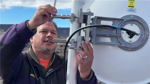
Color photograph of field engineer servicing a remote volcano monitoring site
August 12, 2025 — Upgrading volcano monitoring webcams in the summit region of Mauna Loa

A USGS Hawaiian Volcano Observatory field engineer updates the infrastructure at a remote station in the summit region of Mauna Loa. At this location, two webcams (MOcam and SPcam) were upgraded and a new thermal webcam, the MSTcam, was installed on Mauna Loa summit.  USGS photo by M. Patrick.

A USGS Hawaiian Volcano Observatory field engineer updates the infrastructure at a remote station in the summit region of Mauna Loa. At this location, two webcams (MOcam and SPcam) were upgraded and a new thermal webcam, the MSTcam, was installed on Mauna Loa summit.  USGS photo by M. Patrick.

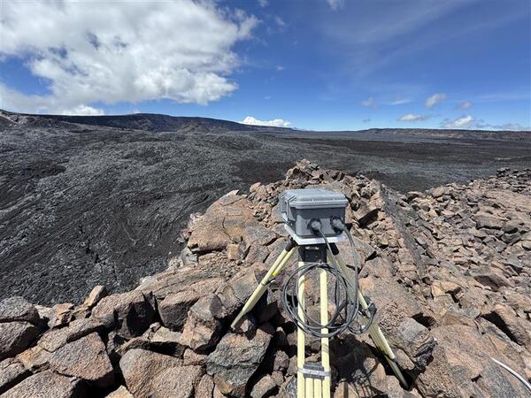
Color photograph of volcano monitoring webcam located on a lava flow near a crater edge
August 12, 2025 — MOcam upgrade on Mauna Loa

The MOcam webcam is situated in the south end of Mokuʻāweoweo, Mauna Loa's summit caldera, and it looks north to monitor the southern portion of the caldera floor.  Nearby, the SPcam is pointed south to monitor the uppermost Southwest Rift Zone of Mauna Loa. USGS photo by M. Patrick.

The MOcam webcam is situated in the south end of Mokuʻāweoweo, Mauna Loa's summit caldera, and it looks north to monitor the southern portion of the caldera floor.  Nearby, the SPcam is pointed south to monitor the uppermost Southwest Rift Zone of Mauna Loa. USGS photo by M. Patrick.

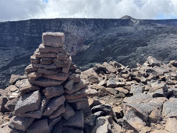
Color photograph of trail cairn near volcanic caldera
August 12, 2025 — Ahu near Mokuʻāweoweo

An ahu (cairn) marks the south end of Mokuʻāweoweo, the caldera at the summit of Mauna Loa.  This photo shows the cone that formed during the Mauna Loa summit eruption in 1949, in the upper right.

An ahu (cairn) marks the south end of Mokuʻāweoweo, the caldera at the summit of Mauna Loa.  This photo shows the cone that formed during the Mauna Loa summit eruption in 1949, in the upper right.

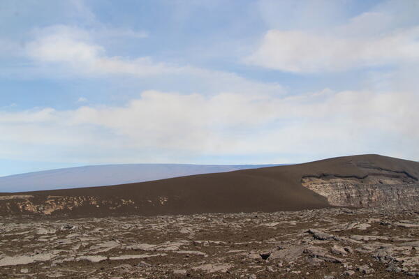
Color photograph of volcanic landscape
July 17, 2025 — Tephra hill southwest of Halema‘uma‘u eruption, Mauna Loa in background

The tephra mound on the crater rim southwest of the active vents in Halemaʻumaʻu is nearly 100 feet (30 m) tall after 28 episodes of lava fountaining since December 23, 2024. The profile of the tephra mound nearly mirrors that of Mauna Loa, outlined behind it. USGS photo by K. Mulliken. 

The tephra mound on the crater rim southwest of the active vents in Halemaʻumaʻu is nearly 100 feet (30 m) tall after 28 episodes of lava fountaining since December 23, 2024. The profile of the tephra mound nearly mirrors that of Mauna Loa, outlined behind it. USGS photo by K. Mulliken. 

Color photograph of volcano monitoring station with cabin in background
2025 Annual Campaign GPS measurements in progress

Campaign, also known as 'survey', GPS data augment the permanent, continuously recording GPS instruments in HVO's monitoring network. In this photo, a tripod mounted with a GPS antenna is temporarily installed over a benchmark the rim of Moku‘āweoweo, the caldera at the summit of Mauna Loa.

Campaign, also known as 'survey', GPS data augment the permanent, continuously recording GPS instruments in HVO's monitoring network. In this photo, a tripod mounted with a GPS antenna is temporarily installed over a benchmark the rim of Moku‘āweoweo, the caldera at the summit of Mauna Loa.

Color map showing ground deformation and outline of a lava flow
Interferometric Synthetic Aperture Radar (InSAR) image of Mauna Loa spanning November 16 to December 2, 2022

Interferometric Synthetic Aperture Radar (InSAR) image of Mauna Loa spanning November 16 to December 2, 2022. Concentric patterns of colored fringes indicate the complex pattern of deformation during the 2022 Mauna Loa eruption. Lava flows are shown by light red areas and summit tiltmeter site locations are shown with white circles.

Interferometric Synthetic Aperture Radar (InSAR) image of Mauna Loa spanning November 16 to December 2, 2022. Concentric patterns of colored fringes indicate the complex pattern of deformation during the 2022 Mauna Loa eruption. Lava flows are shown by light red areas and summit tiltmeter site locations are shown with white circles.

Color photograph of volcanic slopes and mountains
February 12, 2025 — Views of Mauna Kea during Kīlauea summit overflight

Clear weather during a Kīlauea summit monitoring overflight allowed for views of Mauna Kea in the distance, with the slope of Mauna Loa's Northeast Rift Zone visible on the left side of the image. Small amounts of snow from a recent storm remain visible on the slopes of Mauna Kea. USGS photo by P. Dotray.

Clear weather during a Kīlauea summit monitoring overflight allowed for views of Mauna Kea in the distance, with the slope of Mauna Loa's Northeast Rift Zone visible on the left side of the image. Small amounts of snow from a recent storm remain visible on the slopes of Mauna Kea. USGS photo by P. Dotray.

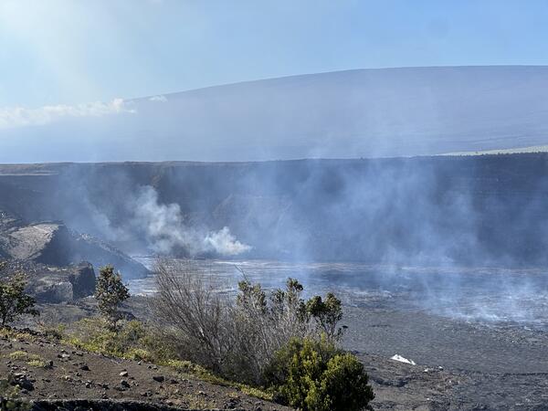
Hazy view of a crater wall with some vegetation in the foreground and a shield-shaped mountain in the background
Hazy conditions caused by sulfur dioxide emissions from Kīlauea, Hawai‘i

Hazy conditions caused by sulfur dioxide (SO2) emissions from Halema‘uma‘u crater, Kīlauea, Hawai‘i.  USGS photo by Jennifer Lewicki, December 25, 2024.

Color photograph of scientist examining equipment that has been knocked over by wind
November 7, 2024 — Getting webcams back online at Mauna Loa summit

High winds at the summit of Mauna Loa ripped several solar panels from their masts, damaging them. HVO staff performed a partial fix to the site to bring the summit webcams back online November 7, 2024. USGS photo by M. Patrick.

High winds at the summit of Mauna Loa ripped several solar panels from their masts, damaging them. HVO staff performed a partial fix to the site to bring the summit webcams back online November 7, 2024. USGS photo by M. Patrick.

Color photograph of instrumentation on a volcano, with a volcano in the background
November 7, 2024 — Getting webcams back online at Mauna Loa summit

HVO staff inspected the radio telemetry site at the summit of Mauna Loa and found wind damage to several components. Mauna Kea is in the background. USGS photo by M. Patrick.

Color photograph of scientist working on instrumentation with volcano in the background
November 7, 2024 — Getting webcams back online at Mauna Loa summit

Mauna Loa summit webcams have been down for several months due to wind damage at the radio telemetry site. On November 7, 2024, HVO staff visited the site and performed a partial fix that brought the webcams back online. Further visits will be needed to repair damaged solar panels. USGS photo by M. Patrick.

Mauna Loa summit webcams have been down for several months due to wind damage at the radio telemetry site. On November 7, 2024, HVO staff visited the site and performed a partial fix that brought the webcams back online. Further visits will be needed to repair damaged solar panels. USGS photo by M. Patrick.

Photo of volcanic cone
August 2, 2024—Sulfur Cone gas monitoring maintenance

On August 2,2024, Hawaiian Volcano Observatory Gas Scientists flew via helicopter to the Sulfur Cone Multi-Gas instrumentation site on Mauna Loa's Southwest Rift Zone, which is at an elevation of 3,430 meters (11,240 feet) above sea level.

On August 2,2024, Hawaiian Volcano Observatory Gas Scientists flew via helicopter to the Sulfur Cone Multi-Gas instrumentation site on Mauna Loa's Southwest Rift Zone, which is at an elevation of 3,430 meters (11,240 feet) above sea level.

Color photograph of volcanic gas monitoring instrumentation
August 2, 2024—Sulfur Cone gas monitoring maintenance

This photograph shows the inside of the Hawaiian Volcano Observatory (HVO) Multi-Gas site at Sulfur Cone. Currently, HVO has 2 of these continuous gas monitoring sites in operation on the Island of Hawai‘i. This one at Sulfur Cone high on Mauna Loa's Southwest Rift Zone, along with one at the summit of Kīlauea.

This photograph shows the inside of the Hawaiian Volcano Observatory (HVO) Multi-Gas site at Sulfur Cone. Currently, HVO has 2 of these continuous gas monitoring sites in operation on the Island of Hawai‘i. This one at Sulfur Cone high on Mauna Loa's Southwest Rift Zone, along with one at the summit of Kīlauea.

Color photograph of volcanic gas monitoring instrumentation
August 2, 2024—Sulfur Cone gas monitoring maintenance

This photograph shows the inside of the Hawaiian Volcano Observatory (HVO) Multi-Gas site at Sulfur Cone. Currently, HVO has 2 of these continuous gas monitoring sites in operation on the Island of Hawai‘i. This one at Sulfur Cone high on Mauna Loa's Southwest Rift Zone, along with one at the summit of Kīlauea.

This photograph shows the inside of the Hawaiian Volcano Observatory (HVO) Multi-Gas site at Sulfur Cone. Currently, HVO has 2 of these continuous gas monitoring sites in operation on the Island of Hawai‘i. This one at Sulfur Cone high on Mauna Loa's Southwest Rift Zone, along with one at the summit of Kīlauea.

Color photograph of volcanic gas monitoring instrument
August 2, 2024—Sulfur Cone gas monitoring maintenance

The continuously monitoring Multi-Gas instrument at Sulfur Cone is housed inside the black Pelican case shown here. Air is pulled into the instrument via a small pump to be analyzed for volcanic gases (Sulfur Dioxide, Hydrogen Sulfide, Carbon Dioxide and Water Vapor).

The continuously monitoring Multi-Gas instrument at Sulfur Cone is housed inside the black Pelican case shown here. Air is pulled into the instrument via a small pump to be analyzed for volcanic gases (Sulfur Dioxide, Hydrogen Sulfide, Carbon Dioxide and Water Vapor).

Color photograph of scientist conducting maintenance on volcanic gas monitoring station
August 2, 2024—Sulfur Cone gas monitoring maintenance

A Hawaiian Volcano Observatory gas scientist works on installing a newly calibrated Multi-Gas instrument at the Sulfur Cone gas monitoring site high up on Mauna Loa's Southwest Rift Zone at an elevation of 3,430 meters (11,240 feet) above sea level. USGS photo by M. Cappos.

A Hawaiian Volcano Observatory gas scientist works on installing a newly calibrated Multi-Gas instrument at the Sulfur Cone gas monitoring site high up on Mauna Loa's Southwest Rift Zone at an elevation of 3,430 meters (11,240 feet) above sea level. USGS photo by M. Cappos.

Black and white image showing location of volcanoes and infrastructure on an island
Map of volcanoes and infrastructure on the Island of Hawaiʻi

Map of Island of Hawaiʻi, highlighting the four active or potentially active volcanoes of the Island, the number of people living on each volcano based on 2020 census data, major roads (transportation corridors) and minor roads (proxy for population density), when each volcano last erupted, and each volcano’s national threat assessment designation.

Map of Island of Hawaiʻi, highlighting the four active or potentially active volcanoes of the Island, the number of people living on each volcano based on 2020 census data, major roads (transportation corridors) and minor roads (proxy for population density), when each volcano last erupted, and each volcano’s national threat assessment designation.

Color photograph of tripod with GPS on it on lava flow with helicopter in the background
May 13, 2024 — Annual Mauna Loa GPS campaign underway

A benchmark on Mauna Loa being surveyed by GPS campaign instruments. The metal disk on the ground beneath the tripod is the benchmark, which is cemented to the lava flow surface. USGS photo by A. Ellis.

A benchmark on Mauna Loa being surveyed by GPS campaign instruments. The metal disk on the ground beneath the tripod is the benchmark, which is cemented to the lava flow surface. USGS photo by A. Ellis.

Color photograph of yellow tripods and boxes organized on pavement
May 13, 2024 — Annual Mauna Loa GPS campaign underway

GPS campaign equipment being staged prior to deployment on Mauna Loa for the annual survey. Temporary GPS receivers and antennas are placed on tripods centered over benchmarks, which serve as a reference point for centering of the antenna. The equipment is left in place to collect data for a couple of days at each site.

GPS campaign equipment being staged prior to deployment on Mauna Loa for the annual survey. Temporary GPS receivers and antennas are placed on tripods centered over benchmarks, which serve as a reference point for centering of the antenna. The equipment is left in place to collect data for a couple of days at each site.

Color photograph of tripod with GPS on lava flow and cabin in the background
May 13, 2024 — Annual Mauna Loa GPS campaign underway

HVO staff are conducting the annual Mauna Loa GPS campaign. During the survey, GPS instruments are deployed at established benchmarks so that their recorded positions can be compared with those from previous years to discern subtle patterns of ground deformation associated with volcanic activity.

HVO staff are conducting the annual Mauna Loa GPS campaign. During the survey, GPS instruments are deployed at established benchmarks so that their recorded positions can be compared with those from previous years to discern subtle patterns of ground deformation associated with volcanic activity.

Color map showing earthquake locations and ground deformation at volcano
May 5, 2024—InSAR image of deformation during Kīlauea upper East Rift Zone swarm

This map shows recent deformation at Kīlauea from April 19 to May 5, 2024, as recorded by the Italian Space Agency's (AGI) Cosmo-SkyMED satellite. Colored fringes denote areas of ground deformation, with more fringes indicating more deformation.  Each color cycle represents 1.5 cm (0.6 in) of ground motion indicative of inflation as the magma reservoi

This map shows recent deformation at Kīlauea from April 19 to May 5, 2024, as recorded by the Italian Space Agency's (AGI) Cosmo-SkyMED satellite. Colored fringes denote areas of ground deformation, with more fringes indicating more deformation.  Each color cycle represents 1.5 cm (0.6 in) of ground motion indicative of inflation as the magma reservoi

Was this page helpful?