Screen capture of Yellowstone Volcano Observatory website in 2001
Screen capture of Yellowstone Volcano Observatory website in 2001Archive view of the Yellowstone Volcano Observatory website in 2001.

Official websites use .gov
A .gov website belongs to an official government organization in the United States.
Secure .gov websites use HTTPS
A lock () or https:// means you’ve safely connected to the .gov website. Share sensitive information only on official, secure websites.
Images of Yellowstone.

Archive view of the Yellowstone Volcano Observatory website in 2001.
Archive view of the Yellowstone Volcano Observatory website in 2001.

Archive view of the Yellowstone Volcano Observatory website in 2009.
Archive view of the Yellowstone Volcano Observatory website in 2009.
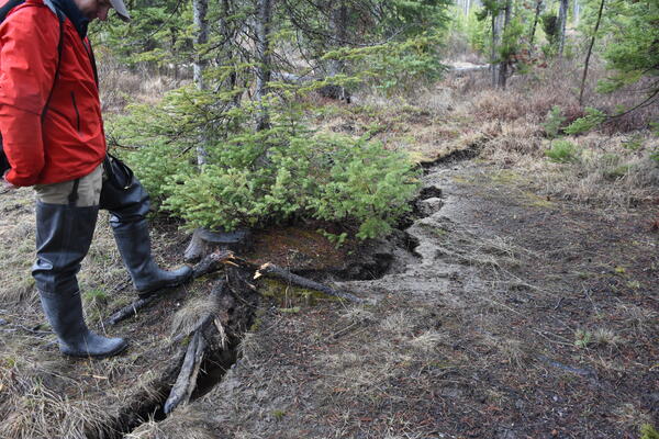
Ground fissure along the shore of Stanley Lake, Idaho, cause by liquefaction during shaking from the March 31, 2020, Stanley earthquake. Photo by Zach Lifton, Idaho Geological Survey, May 2020.
Ground fissure along the shore of Stanley Lake, Idaho, cause by liquefaction during shaking from the March 31, 2020, Stanley earthquake. Photo by Zach Lifton, Idaho Geological Survey, May 2020.
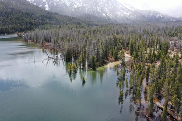
Submerged trees at the inlet delta of Stanley Lake, Idaho. Liquefaction during shaking from the March 31, 2020, Stanley earthquake caused ground subsidence and collapse of the delta. Photo by Zach Lifton, Idaho Geological Survey, May 2020.
Submerged trees at the inlet delta of Stanley Lake, Idaho. Liquefaction during shaking from the March 31, 2020, Stanley earthquake caused ground subsidence and collapse of the delta. Photo by Zach Lifton, Idaho Geological Survey, May 2020.

Grand Prismatic Spring in Midway Geyser Basin Yellowstone National Park on October 19, 2017.
Grand Prismatic Spring in Midway Geyser Basin Yellowstone National Park on October 19, 2017.

Sunset lake in Black Sand Basin of Yellowstone National Park
Sunset lake in Black Sand Basin of Yellowstone National Park

The relationship between Δ30 and N2/3He ratios in hydrothermal gases from Iceland and Yellowstone. Δ30 and N2/3He ratios are shown for samples collected from gases in Iceland (yellow circles) and Yellowstone (red circles). The Yellowstone mantle-endmember is arguably indistinguishable in terms of N2/3He from the convecting upper mantle (grey diamonds).
The relationship between Δ30 and N2/3He ratios in hydrothermal gases from Iceland and Yellowstone. Δ30 and N2/3He ratios are shown for samples collected from gases in Iceland (yellow circles) and Yellowstone (red circles). The Yellowstone mantle-endmember is arguably indistinguishable in terms of N2/3He from the convecting upper mantle (grey diamonds).

Map of USGS “Did You Feel It?” reports for the March 31, 2020, M6.5 Stanley, Idaho, earthquake. Taken from https://earthquake.usgs.gov/earthquakes/eventpage/us70008jr5/dyfi/intensity.
Map of USGS “Did You Feel It?” reports for the March 31, 2020, M6.5 Stanley, Idaho, earthquake. Taken from https://earthquake.usgs.gov/earthquakes/eventpage/us70008jr5/dyfi/intensity.

Imperial Geyser hot spring pool in Yellowstone National Park is about 30 m (about 100 ft) across and contains alkaline-Cl waters with a steam vent in the pool and mudpots outside the pool area (in the upper right part of this photo). USGS Photo by Pat Shanks, 2019.
Imperial Geyser hot spring pool in Yellowstone National Park is about 30 m (about 100 ft) across and contains alkaline-Cl waters with a steam vent in the pool and mudpots outside the pool area (in the upper right part of this photo). USGS Photo by Pat Shanks, 2019.

Annie Carlson, Research Permitting Coordinator for Yellowstone National Park during 2017–2023, during a winter ski expedition in the park. National Park Service photo by Jon Nicholson, January 2020.
Annie Carlson, Research Permitting Coordinator for Yellowstone National Park during 2017–2023, during a winter ski expedition in the park. National Park Service photo by Jon Nicholson, January 2020.

Sabrina Brown collecting samples from Yellowstone Lake core YL16-2C at the National Lacustrine Core Facility (LacCore) at the University of Minnesota.
Sabrina Brown collecting samples from Yellowstone Lake core YL16-2C at the National Lacustrine Core Facility (LacCore) at the University of Minnesota.

Mineral stability diagram showing minerals that are stable under changing temperature and dissolved silica concentrations that are found at and just beneath the floor of Yellowstone Lake. Two important points illustrated by this diagram are: (1) the minerals that are stable when reacted with vapor-dominated fluids (kaolinite, boehmite) differ substantially fro
Mineral stability diagram showing minerals that are stable under changing temperature and dissolved silica concentrations that are found at and just beneath the floor of Yellowstone Lake. Two important points illustrated by this diagram are: (1) the minerals that are stable when reacted with vapor-dominated fluids (kaolinite, boehmite) differ substantially fro

Contrasting photos of Heart Spring on Geyser Hill in the Upper Geyser Basin from 1998 (left) and 2019 (right). Can you spot differences in the hot spring? Photos courtesy of the National Park Service.
Contrasting photos of Heart Spring on Geyser Hill in the Upper Geyser Basin from 1998 (left) and 2019 (right). Can you spot differences in the hot spring? Photos courtesy of the National Park Service.

The Yellowstone River is divided into five reaches (labeled and color-coded): Yellowstone Lake, Hayden Valley, Grand Canyon of the Yellowstone, Tower–Gardner, and Mammoth. Monitoring stations (yellow dots on map) between each reach of the river reaches allow geochemists to measure river composition and then determine the sources of chloride (Cl) and other solu
The Yellowstone River is divided into five reaches (labeled and color-coded): Yellowstone Lake, Hayden Valley, Grand Canyon of the Yellowstone, Tower–Gardner, and Mammoth. Monitoring stations (yellow dots on map) between each reach of the river reaches allow geochemists to measure river composition and then determine the sources of chloride (Cl) and other solu

Map showing ice cover in the Yellowstone region. Light shaded areas bounded by black and red lines indicate areas covered during the Pinedale (about 20,000-15,000 years ago) and Bull Lake (about 150,000 years ago) glaciations, respectively. Blue lines are contours in thousands of feet on the maximum reconstructed Pinedale glacier surface.
Map showing ice cover in the Yellowstone region. Light shaded areas bounded by black and red lines indicate areas covered during the Pinedale (about 20,000-15,000 years ago) and Bull Lake (about 150,000 years ago) glaciations, respectively. Blue lines are contours in thousands of feet on the maximum reconstructed Pinedale glacier surface.

Color-shaded topographic relief map of the Yellowstone Plateau-Snake River Plain volcanic province showing the track of the Yellowstone hot spot.
Color-shaded topographic relief map of the Yellowstone Plateau-Snake River Plain volcanic province showing the track of the Yellowstone hot spot.

An unnamed small acidic (pH ~3) hot spring (with a temperature of about 55°C at the source) in the Gibbon Geyser Basin of Yellowstone National Park. The yellow region is due to the precipitation of sulfur by sulfide-oxidizing chemotrophic microorganisms.
An unnamed small acidic (pH ~3) hot spring (with a temperature of about 55°C at the source) in the Gibbon Geyser Basin of Yellowstone National Park. The yellow region is due to the precipitation of sulfur by sulfide-oxidizing chemotrophic microorganisms.
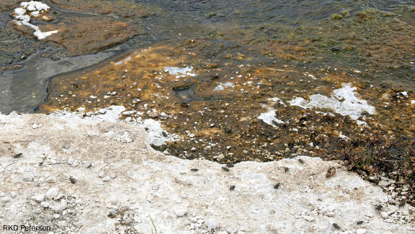
Several adult wetsalts tiger beetles hunting and basking on and around an alkaline hot spring near Midway Geyser Basin in Yellowstone National Park. Photo by Robert K. D. Peterson, 2019.
Several adult wetsalts tiger beetles hunting and basking on and around an alkaline hot spring near Midway Geyser Basin in Yellowstone National Park. Photo by Robert K. D. Peterson, 2019.

Rhyolite lavas in the Yellowstone Caldera younger than 631,000 years
Rhyolite lavas in the Yellowstone Caldera younger than 631,000 years

Models of magma storage. Part (A) depicts the standard model of magma storage—a single, large body of crystal-poor melt, surrounded by crystalline mush. Although this is the standard 'mush' model, geophysical studies fail to find evidence of this type of magma storage at many active systems.
Models of magma storage. Part (A) depicts the standard model of magma storage—a single, large body of crystal-poor melt, surrounded by crystalline mush. Although this is the standard 'mush' model, geophysical studies fail to find evidence of this type of magma storage at many active systems.

Map showing three types of young faults in Yellowstone National Park. 1) Resurgent dome faults. 2) Volcanism and caldera faults. 3) Basin and Range faults. Courtesy of the Wyoming State Geological Survey.
Map showing three types of young faults in Yellowstone National Park. 1) Resurgent dome faults. 2) Volcanism and caldera faults. 3) Basin and Range faults. Courtesy of the Wyoming State Geological Survey.