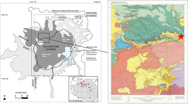
U.S. flag

An official website of the United States government

Images

Images of Yellowstone.

Filter Total Items: 690
Graphic depicting the distribution of Yellowstone ash across the U....
Map of volcanic ash fall as a result of eruptions from Yellowstone,...

Map of volcanic ashfall. Areas of the United States that once were covered by volcanic ash from Yellowstone's giant eruptions 2 million and 630,000 years ago, compared with ashfall from the 760,000-year-old Long Valley caldera eruptions at Mammoth Lakes, California, and the 1980 eruption of Mount St. Helens, Washington.

Map of volcanic ashfall. Areas of the United States that once were covered by volcanic ash from Yellowstone's giant eruptions 2 million and 630,000 years ago, compared with ashfall from the 760,000-year-old Long Valley caldera eruptions at Mammoth Lakes, California, and the 1980 eruption of Mount St. Helens, Washington.

geological map with colors depending different rock units
Excerpt from the MBMG Geological Map of the Gardiner 30’ x 60’ Quadrangle

Excerpt from the Geological Map of the Gardiner 30’ x 60’ Quadrangle, South-Central Montana, by Berg and others (1999), focused on Devil’s Slide (colorful blue-green stripes at center of map excerpt).  Full unit description and map available online as Montana Bureau of Miles and Geology Open File No.

Excerpt from the Geological Map of the Gardiner 30’ x 60’ Quadrangle, South-Central Montana, by Berg and others (1999), focused on Devil’s Slide (colorful blue-green stripes at center of map excerpt).  Full unit description and map available online as Montana Bureau of Miles and Geology Open File No.

Steam rises from a hot pool. The foreground is barren, and the background has some low tropical vegetation.
Agua Shuca thermal area, El Salvador

Steam rises above a hot pool at Agua Shuca, one of many thermal areas of the Ahuachapán geothermal field of El Salvador. A sudden hydrothermal explosion at Agua Shuca in October 1990 ejected steam and debris within a 200-m-radius, and about 25 people living adjacent to the thermal area were killed.

Steam rises above a hot pool at Agua Shuca, one of many thermal areas of the Ahuachapán geothermal field of El Salvador. A sudden hydrothermal explosion at Agua Shuca in October 1990 ejected steam and debris within a 200-m-radius, and about 25 people living adjacent to the thermal area were killed.

Geologists in Little Dipper boat on Grand Prismatic Spring

Yellowstone National Park employees Rick Hutchinson (right) and Jim Peaco (left) guide the specially designed Little Dipper boat into the boiling waters of Grand Prismatic Spring to collect measurements of the temperature and structure of the feature. National Park Service photo by Josh Robbins in 1996.

Yellowstone National Park employees Rick Hutchinson (right) and Jim Peaco (left) guide the specially designed Little Dipper boat into the boiling waters of Grand Prismatic Spring to collect measurements of the temperature and structure of the feature. National Park Service photo by Josh Robbins in 1996.

Queen's Laundry bathhouse, in the Lower Geyser Basin of Yellowstone National Park
Queen's Laundry bathhouse, in Yellowstone's Lower Geyser Basin

Queen's Laundry bathhouse, in the Lower Geyser Basin of Yellowstone National Park.  Building began under superintendent Philetus Norris in 1881 but was never finished.

Gas plume rises above lava fountains in a lava lake in the summit crater of Nyiragongo volcano, Democratic Republic of the Congo, on 20 August 1994

A gas plume rises above lava fountains in a lava lake in the summit crater of Nyiragongo volcano on 20 August 1994. USGS photo by Jack Lockwood.

Black and white line drawing showing the geology of the Wind River Range, Wyoming
Geologic map of the Wind River Range, Wyoming

Geologic map of the Wind River Range from Blackstone, 1993 (The Wind River Range, Wyoming: An Overview. Wyoming Geological Association. Jubilee Anniversary Field Conference Guidebook: Wyoming Geology, Past, Present, and Future. Pg. 121-140).

Geologic map of the Wind River Range from Blackstone, 1993 (The Wind River Range, Wyoming: An Overview. Wyoming Geological Association. Jubilee Anniversary Field Conference Guidebook: Wyoming Geology, Past, Present, and Future. Pg. 121-140).

Deep-ocean hydrothermal vent system from the East Pacific Rise

Photo of a deep-ocean hydrothermal vent system from the East Pacific Rise at 9º39’N latitude and 2550 m (8366 ft) depth showing vigorously venting “black smoker” hydrothermal fluids (329 °C, or 624 °F) that are dark gray to black due to rapid precipitation of iron, copper, and zinc sulfide minerals as the hot water mixes with cold bottom waters.

Photo of a deep-ocean hydrothermal vent system from the East Pacific Rise at 9º39’N latitude and 2550 m (8366 ft) depth showing vigorously venting “black smoker” hydrothermal fluids (329 °C, or 624 °F) that are dark gray to black due to rapid precipitation of iron, copper, and zinc sulfide minerals as the hot water mixes with cold bottom waters.

Track of the Yellowstone hotspot showing the ages and locations of volcanic fields

Color-shaded relief topographic map of the track of the Yellowstone hotspot showing the ages and locations of volcanic fields and faulting patterns which become younger to the northeast.  Areas in cooler colors (greens and blues) represent low topographic elevations, whereas warmer colors (oranges and reds) represent high elevations.  Adapted from

Color-shaded relief topographic map of the track of the Yellowstone hotspot showing the ages and locations of volcanic fields and faulting patterns which become younger to the northeast.  Areas in cooler colors (greens and blues) represent low topographic elevations, whereas warmer colors (oranges and reds) represent high elevations.  Adapted from

water shoots from a rock wall, with forest in the background
Apollinaris Spring, Yellowstone National Park, in 1987

Apollinaris Spring in 1987.  The spring was modified in 1925 so that water would flow through pipes to be emitted from a rock wall.  Yellowstone National Park photo by Jim Peaco.

Apollinaris Spring in 1987.  The spring was modified in 1925 so that water would flow through pipes to be emitted from a rock wall.  Yellowstone National Park photo by Jim Peaco.

Muddy thermal discharge near Congress Pool in Norris Geyser Basin following the 1975 Yellowstone National Park earthquake

Muddy thermal discharge (foreground) near Congress Pool (middle ground) in Norris Geyser Basin following the June 30, 1975, magnitude-6 Yellowstone National Park earthquake,  NPS photo by Rick Hutchinson.

Morning Glory pool, before and after garbage clean out
Morning Glory Pool before and after garbage clean out, Yellowstone.

Morning Glory Pool used to be clear blue in color, as shown in the historic undated photo on the left (National Park Service photo by Rentchler).

1975 earthquake damage just south of Mammoth Hot Springs on the Mammoth-Norris highway

Photo of damage to the Mammoth-Norris highway, just south of Mammoth Hot Springs, caused by the June 30, 1975, magnitude-6 earthquake.  Haynes Inc. photo for the Deseret News.

Gibbon River in Gibbon Meadows immediate following the 1975 Yellowstone National Park earthquake

Gibbon River in Gibbon Meadows immediate following the June 30, 1975, magnitude-6 Yellowstone National Park earthquake.  The muddy color is due to increased sediment load.  NPS photo by Rick Hutchinson.

Shoshone Tukudika (Sheepeater) at Medicine Lodge Creek, Idaho, in 1871.
Shoshone Tukudika (Sheepeater) at Medicine Lodge Creek, Idaho, in 1871

Shoshone Tukudika (Sheepeater) men, women, and children at Medicine Lodge Creek, Idaho, in 1871. This photo was taken by U.S. Geological Survey employee William Henry Jackson.  Courtesy of National Park Service, Yellowstone National Park, YELL 8151.

Shoshone Tukudika (Sheepeater) men, women, and children at Medicine Lodge Creek, Idaho, in 1871. This photo was taken by U.S. Geological Survey employee William Henry Jackson.  Courtesy of National Park Service, Yellowstone National Park, YELL 8151.

Was this page helpful?