



Understanding & Finding Hydrologic Unit Codes (HUCs)
In this activity, students will explore what watersheds are and why they matter, learn how Hydrologic Unit Codes (HUCs) describe watershed scales, use USGS tools to identify the HUC for a chosen location, and compare local and regional watersheds to understand how water connects communities.
Understanding & Finding Hydrologic Unit Codes (HUCs) - Lesson Plan [PDF])
Understanding & Finding Hydrologic Unit Codes (HUCs) [DOC]
WBD Snapshot

Understanding & Finding Hydrologic Unit Codes (HUCs)
Objectives:
- Define a watershed and explain why watersheds are important.
- Describe what a Hydrologic Unit Code (HUC) represents.
- Explain how HUCs become more specific as the number of digits increases.
- Locate the watershed for their home, school, or another location using USGS mapping tools.
- Compare their local watershed to larger watersheds and explain how water connects communities.
Recommended level: Grades 6 – 12
Next Generation Science Standards (NGSS) Standards:
- DCIs: 5-ESS2-1: Develop a model using an example to describe ways the geosphere, biosphere, hydrosphere, and atmosphere interact, MS-ESS2-4: Develop a model to describe the cycling of water through Earth's systems, HS-ESS2-5: Plan and conduct an investigation of Earth's dynamic systems and how water moves through them.
- CCCs: Systems and Systems models, Scale, Proportion, and Quantity, Patterns
- SEPs: Developing and using models, Asking questions, Analyzing and interpreting data, Using digital tools
Key Terms:
- Watershed- An area of land where all the water that falls or flows across it drains into the same stream, river, or lake.
- Hydrologic Unit - A hydrologic unit is an area of land like a watershed or basin where all the water like rain and runoff, flows toward a particular part of a stream. Hydrologic units come in various sizes, which are nested. Depending on the scale, an individual river may include water flowing from several hydrologic units upstream.
- Hydrologic Unit Code (HUC) - A number used by scientists and agencies to identify different drainage areas. Each HUC represents a specific watershed or basin at a particular scale.
- Drainage divide - A line that marks the edge of an area. For watersheds, it’s the line that separates where water flows into one watershed versus another.
- Tributary - A smaller stream or river that flows into a larger one.
- Headwaters - The place where a river or stream begins, in higher elevations or in the mountains
- River Basin - A large region of land drained by a major river and all of its tributaries.
Topography - The shape and features of the land, including hills, valleys, and slopes, which affect how water flows across a landscape.
Background
Imagine if every watershed had its own mailing address. Instead of street names and ZIP Codes, scientists use Hydrologic Unit Codes (HUCs) to identify watersheds across the United States.
A watershed is an area of land where all precipitation and runoff drain to the same stream, river, lake, or ocean. Watersheds are separated by high points in the landscape, such as hills or mountain ridges, called drainage divides. In a flatter landscape, these divides can be very subtle, where there is just a small change in slope.
The U.S. Geological Survey (USGS) and other federal agencies developed the Hydrologic Unit Code (HUC) system to organize watersheds into a nested hierarchy. Each additional set of digits identifies a smaller and more detailed watershed.
Think of it like this:
| HUC Level | Example hydrologic unit code | Average size range (acres) |
| HUC2 | 01 | - |
| HUC4 | 0108 | - |
| HUC6 | 010802 | - |
| HUC8 | 01080204 | - |
| HUC10 | 0108020401 | 40,000 – 250,000 |
| HUC12 | 010802040101 | 10,000 – 40,000 |
Hydrologic Units TM11-A3 5th Edition: Federal Standards and Procedures for the National Watershed Boundary Dataset (WBD)
A HUC works much like an address:
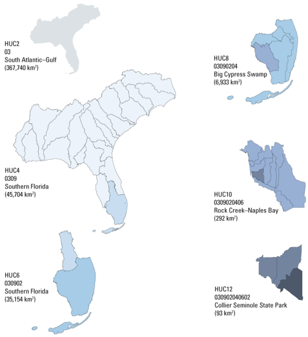
United States → State → City → Street → House Number
Similarly:
HUC2 → HUC4 → HUC6 → HUC8 → HUC10 → HUC12
The more digits, the smaller the watershed.
HUCs are used by scientists, engineers, emergency managers, and resource professionals to understand the locations in which to:
- Monitor floods
- Study drought
- Track water quality
- Manage drinking water supplies
- Restore streams and wetlands
- Protect fish and wildlife habitat
- Understand how pollution moves downstream
Knowing a watershed's "water address" or HUC helps people make informed decisions about managing and protecting water resources.
Think - Individually
- Where does rain go after it falls?
- Does all rain end up in the same river?
- What determines where water flows?
- If two houses are only one street apart, could they be in different watersheds?
Why might scientists want a way to identify watersheds?
Review - Pair or Group Discussion
Navigate to: https://water.usgs.gov/themes/hydrologic-units/#nhdplus-hr-wbd-snapshot
Take a few minutes to explore the map, play with different features and discuss the following questions with your group or partner
- Why are some watershed areas much larger than others?
- What happens when more digits are added to a HUC?
- Why might scientists use different watershed sizes?
Analyze and Reflect - Answer individually or in small groups
- Which HUC level covers the largest geographic area?
- Which HUC level provides the most detailed local information?
Why might it be useful to organize watersheds this way?
Explore - Students should use the NHDPlus V2 WBD Snapshot map to complete the following activity.
How to use the map
The map will open at the HUC 2 level. In this view, you can look at the U.S. map and use the blue outlines to identify your HUC 2 region.
- Enter the ZIP code for the location you want to look up.
- Open the “Jump to Zoom Level” dropdown menu and select the HUC level you want (e.g., HUC 4, HUC 6, HUC 8).
- Click on your location on the map to see the specific HUC for that area.
Additional Notes
- In the upper-right corner of the map, you can select “Control Map” to enable drag-and-move navigation.
- You can also change the map view (for example, switch from imagery to topo).
- Students should search for one of the following:
- Home address
- School
- Family member's home
- Students record their answers in the following table:
- Your HUC2, HUC10, and HUC12
- What is the largest downstream watershed that your watershed drain into?
| Location | |
| HUC2 | |
| HUC10 | |
| HUC12 | |
| Largest Watershed your watershed drains into |
- Once you have recorded that information and determined your HUC12, navigate to the 2025 WBD snapshot map
- Look up the same zipcode, is the HUC12 the same or different?
- Select the EPA “How’s my Waterway” link for your HUC12. The link will pull up a map of your HUC12 on the left side of the page and on the right side of the webpage you will see reports for your local waterbodies. Answer the following questions using the map and reports.
- How may waterbodies are located in your subwatershed?
- Are all the waterbodies in your sub-watershed in “good” status (use report legend to determine this)
- If not, describe any issues you see with the waterbodies using the reports.
- Why is it important to know the condition of waterbodies in your watershed?
- Make Your Watershed ID Card - Using a large index card, and the information gathers from previous questions create your own watershed ID card. Include:
- Your location
- HUC10
- HUC12
- Small sketch of the watershed
- Include boundary and tributary lines seen on the EPA “How’s my water Map?”
- Where does you subwatershed drain into?
One interesting fact about your watershed
Optional Extension
Choose a famous place in the United States. It may be helpful to know the zipcode of the place before beginning your HUC search.
Examples:
- Yellowstone National Park - 82190 (Wyoming, park headquarters), 59030 (Montana entrance at Gardiner)
- Grand Canyon - 86023 South Rim (main visitor area), 86052 (North Rim)
- Mount Rainier - 98304 (general park area), 98355 (Longmire), 98022 (Enumclaw)
- Everglades National Park - 33034 (Florida City / Homestead)
- Great Smoky Mountains - 37738, Tennessee side (Gatlinburg), 28719, North Carolina side (Cherokee)
Find:
| Place | |
| HUC12 | |
| Watershed Name | |
| Where does water end up? |
Create a short presentation or infographic explaining your findings.