
Coastal and Marine Hazards and Resources Program Decadal Science Strategy Published
This geonarrative constitutes the Decadal Science Strategy of the USGS's Coastal and Marine Hazards and Resources Program for 2020 to 2030.
Foreword

By John Haines (former Coastal and Marine Hazards and Resources Program Coordinator)
I am happy to announce the release of the Coastal and Marine Hazards and Resources Decadal Science Strategy.
This Science Strategy successfully achieves the goals we set when we began this project. The plan encompasses the breadth of our Program’s objectives and activities. Every member of our Program had an opportunity to define our goals and how we will set priorities and pursue those goals into the future. And, the plan has been delivered in a modern digital format which allows readers to “explore” our program as best suits them individually and gives us the ability to continuously enhance and update this important entry point into our Program.
The summary below from Carolyn Ruppel (Woods Hole Coastal and Marine Science Center) and Soupy Dalyander (formerly of the St. Petersburg Coastal and Marine Science Center) announces the completion and publication of the Decadal Science Strategy, briefly describes the content and format, and acknowledges some of the substantial individual contributions made throughout this process.
Special thanks are owed to Soupy Dalyander and the various teams that worked closely with her to develop the plan. They took ownership of the project and brought coherence and structure to the plan, ensuring the process honored the diverse viewpoints from across the program. As the final remaining member of the original plan team, Carolyn Ruppel stepped up in Spring 2019 to shepherd the plan through the final publication process. I extend my appreciation to the dozens of personnel from across the Program who contributed text, images, reviews, aesthetic ideas, and scientific advice. The unflagging commitment of Program personnel to bringing this effort to successful completion has produced a visually-arresting plan that highlights the Program’s unique strengths in a format accessible to stakeholders and government managers.
Summary
By Carolyn Ruppel (Woods Hole Coastal and Marine Science Center) and Soupy Dalyander (formerly of the St. Petersburg Coastal and Marine Science Center)
When the Coastal and Marine Hazards and Resources Program published its Decadal Science Strategy in January 2020, it was the culmination of a years-long effort that involved dozens of the Program’s researchers, technical staff, and outreach experts. The Strategic Plan describes the vision, goals, and strategic framework for the Program’s activities and scientific research, which are conducted to inform stakeholders and serve the Nation’s need for high-quality, timely, and impartial scientific information about hazards and resources in coastal and marine environments.
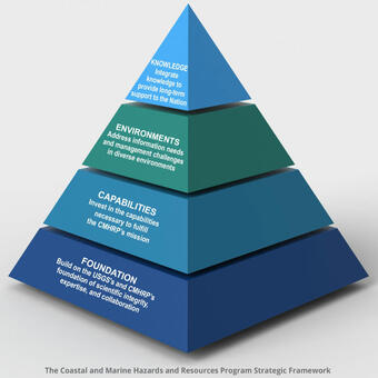
The Science Strategy opens with an overview of the Program, articulating a vision of “a nation prepared for coastal and ocean changes” and describing examples of the Program’s work to address hazard preparedness and response and national resource management. The strategic framework, which provides the structure for the rest of the plan, first describes the Program’s foundational principles, which include scientific integrity, a flexible workforce, and internal and external partnerships. The next part of the strategic framework focuses on the program’s capabilities for designing research to address knowledge gaps, acquiring and analyzing data, building predictive models, and preserving information. The strategic framework then shifts focus to the environments in which the Program conducts research—estuaries and wetlands, open coasts, the continental shelf, and the continental slope and deep sea. The environments sections constitute the largest part of the plan and articulate the unique needs, challenges, and strategies that the Program has identified for each setting. The final element of the strategic framework is integration of knowledge across environments and beyond the Program. This section focuses on analysis and synthesis of information, devising appropriate scientific tools for hazard and resource management, and outreach to stakeholders.
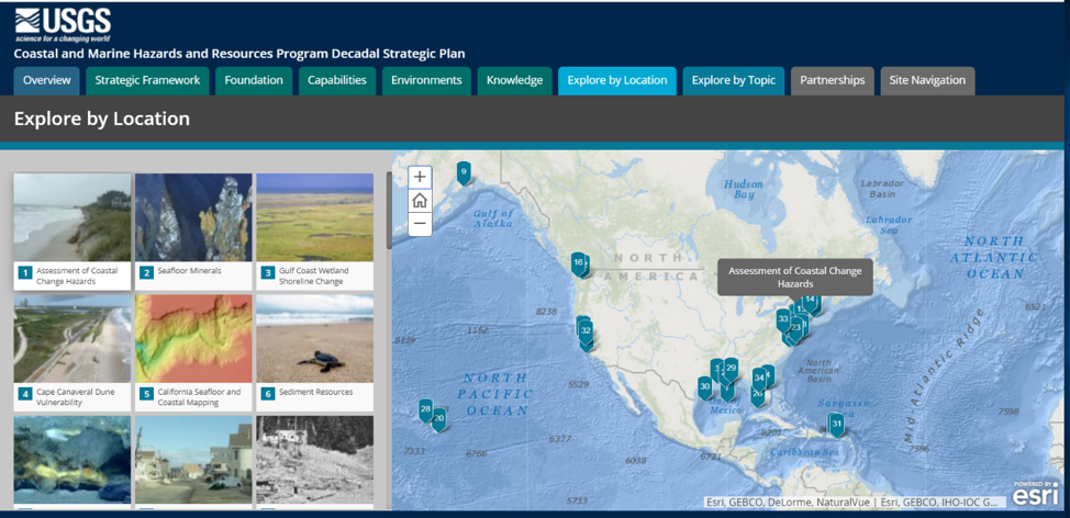
A key feature of the plan is 34 short vignettes, each describing a Program research project, result, or aspect of work. The vignettes are characterized by visuals alongside text descriptions, which provide detail and further examples to illustrate the concepts of the plan. All Program-supported Science Centers contributed to these vignettes, which cover topics as diverse as coastal zone hazards, earthquakes and tsunamis, U.S. Extended Continental Shelf mapping, estuarine ecosystems recovery, seafloor minerals, coral reefs, Arctic environmental change, coastal groundwater systems, and gas hydrates. The vignettes also explore Program capabilities (such as seafloor mapping, marine seismic imaging, and LIDAR) and describe the Program’s partnerships with Federal, state, and local agencies. The vignettes are linked as web pages that can be discovered by users in two ways, “Explore by Topic” and “Explore by Location.”
Formulating the Science Strategy involved many Program personnel over several years. The effort launched by John Haines (Program Coordinator) in the middle of the 2010s included early teams focused on the plan structure and generating content, an effort which continued with thematic groups focused on the different environments for Program research (wetlands and estuaries, open coasts, continental shelf, and upper continental slope/deep water) and on the Program’s capabilities. By late 2015, the effort had evolved into a smaller writing group that included Laura Brothers (Woods Hole Coastal and Marine Science Center [WHCMSC]), Soupy Dalyander (formerly USGS), Amy East (Pacific Coastal and Marine Science Center [PCMSC]), Nadine Golden (PCMSC), Nathaniel Plant (St. Petersburg Coastal and Marine Science Center [SPCMSC]), Carolyn Ruppel (WHCMSC), Peter Swarzenski (PCMSC), John Warner (WHCMSC), and Kim Yates (SPCMSC). In 2016 and 2017, Susan Russell-Robinson (formerly USGS) led a subgroup that focused on refining the mission and vision for the plan, thereby transforming the plan from a description of the existing program into a more forward-looking and strategic document. This draft and several subsequent iterations were internally reviewed by Program staff and management, as well as by managers outside of the Program.
The Science Strategy is the first programmatic planning document that the USGS has published as a digital geonarrative (ESRI story map), instead of traditional hardcopy booklet. Starting in 2018, a core team consisting of Soupy Dalyander, Nadine Golden, Carolyn Ruppel, and Joe Stachyra (SPCMSC) worked with Ellen Kappel (Geo Prose, Inc.) and Johanna Adams (Geo Prose, Inc.) to formulate the entire plan as multiple geonarratives. Alongside the text, the plan features rich visual displays, including seafloor maps, underwater and LIDAR imagery, model output, USGS photographs of hazards and resources phenomena, and images of the Program personnel leading outreach efforts and conducting scientific work on ships, at the coasts, and in laboratories. Betsy Boynton (Cherokee Nation Technologies) provided substantial assistance in managing graphics for the plan, and Richard Snell (Cherokee Nation Technologies) completed much of the programming required to give the plan its professional USGS look and to comply with USGS publications requirements. Ann Tihansky (Coastal and Marine Hazards and Resources Program) coordinated the creation of the vignette web pages made by Andrea Babb (WHCMSC), Jolene Gittens (SPCSMC), and Laura Torresan (PCMSC).
Explore the Science Strategy online. Updates, new web content, and information about new directions will be linked to the plan to ensure it remains current with respect to the evolving priorities, capabilities, and focus of the program.
Disclaimer: Any use of trade, firm, or product name is for descriptive purposes only and does not imply endorsement by the U.S. Government.
Related

The CMHRP Decadal Science Strategy 2020-2030 The CMHRP Decadal Science Strategy 2020-2030
Related