This geonarrative constitutes the Decadal Science Strategy of the USGS's Coastal and Marine Hazards and Resources Program for 2020 to 2030.
The Decadal Science Strategy of the Coastal and Marine Hazards and Resources Program (CMHRP) describes the CMHRP's vision and mission and the strategic framework needed to support key program goals: Conduct research and develop science-based tools that lead to safer, more productive coastal communities and improved stewardship of natural resources.
Tips for navigating this Plan
This information explains how to navigate this website so that you get the most out of the experience
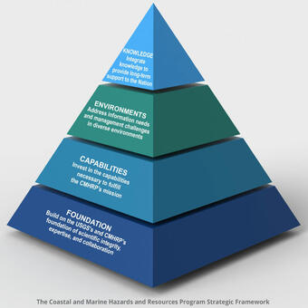
Strategic Framework
The CMHRP uses four overarching approaches to develop our research program
Foundation
The CMHRP's high quality reputation is built on scientific integrity, expertise, and collaboration with partners
Capabilities
CMHRP invests in diverse capabilities to achieve our mission.
Knowledge
The CMHRP creates a bridge between the research community and decision makers
Environments: See where we work


Related Content
Explore examples of our science that are featured in the Plan.
Delineating the U.S. Extended Continental Shelf
California Seafloor and Coastal Mapping Program
Atlantic and Gulf of Mexico Submarine Landslides-Tsunami Hazards Project
Climate Change on U.S. Arctic Ocean Margins
Deep Sea Corals
Measuring Sediment Flux in Blackwater National Wildlife Refuge
The Coupled Ocean-Atmosphere-Wave-Sediment Transport Modeling System
Caribbean Tsunami and Earthquake Hazards
The Coastal Storm Modeling System
Elwha River Restoration Project
Fire Island National Seashore
CMHRP Response to Hurricane Sandy in Estuaries and Wetlands
Related Content
- Science
Explore examples of our science that are featured in the Plan.
Filter Total Items: 34Delineating the U.S. Extended Continental Shelf
The United States has an interest in knowing the full extent of its continental shelf beyond 200 nautical miles from shore (called the extended continental shelf, or ECS) so that it can better protect, manage and use the resources of the seabed and subsoil contained therein. The USGS contributes to the ECS effort through membership and leadership on the interagency U.S. ECS Task Force, a group...California Seafloor and Coastal Mapping Program
A Foundation for Characterizing Hazards, Monitoring Change, and Managing ResourcesAtlantic and Gulf of Mexico Submarine Landslides-Tsunami Hazards Project
Submarine landslides and tsunamis along the U.S. Atlantic and Gulf of Mexico coasts are rare, but the risks associated with these natural hazards are high. While most earthquakes in these margins are low in magnitude, and so shaking from them is not intense, they can still cause a lot of damage. The Atlantic and Gulf of Mexico margins are heavily urbanized, support extensive port and industrial...Climate Change on U.S. Arctic Ocean Margins
Arctic Alaska is warming faster than the rest of the United States. A major consequence of this warming is permafrost thaw, which threatens infrastructure, alters habitat, increases fire risk, changes nutrient and sediment delivery to the coastal ocean, and enhances greenhouse gas release. The warming climate has already dramatically reduced the thickness and annual duration of sea ice, rendering...Deep Sea Corals
Deep-sea corals are slow-growing marine organisms that live at water depths greater than light can penetrate. These corals are widely distributed on the outer continental shelves and slopes of U.S. margins and are considered especially vulnerable to damage by activities such as trawling given their slow regeneration time.Measuring Sediment Flux in Blackwater National Wildlife Refuge
The Blackwater National Wildlife Refuge (NWR), Maryland, is a tidal wetland complex that has rapidly lost vegetated marsh to open water due to invasive species, sea level rise, and landscape change. The stability of this wetland complex and others nationally has consequences for habitat availability, retention of carbon stores in soils, and coastal flood protection.The Coupled Ocean-Atmosphere-Wave-Sediment Transport Modeling System
To responsibly manage our coastal resources requires an understanding of the processes responsible for coastal change. The CMHRP developed a Coupled Ocean–Atmosphere–Wave–Sediment Transport (COAWST) modeling system that allows the user to evaluate how different processes such as winds and waves, combined with sediment transport, interact with coastlines to modify them. Users can change model...Caribbean Tsunami and Earthquake Hazards
Four million U.S. citizens live along the coastlines of Puerto Rico and the U.S. Virgin Islands, an earthquake- and tsunami-prone active tectonic plate boundary. A tsunami generated at the subduction zone boundary offshore Puerto Rico could also affect the U.S. Atlantic coast.The Coastal Storm Modeling System
The Coastal Storm Modeling System (CoSMoS) provides emergency responders and coastal planners with critical storm-hazard information such as flood extent, flood depth, duration of flooding, wave height, and currents that can be used to increase public safety, mitigate physical damages, and more effectively manage complex coastal settings. The CMHRP initially developed CoSMoS in collaboration with...Elwha River Restoration Project
From 2011 to 2014, the Nation’s largest dam removal project to date took place in Washington State, allowing the Elwha River to once again flow unimpeded from its origin in the Olympic Mountains to the Strait of Juan de Fuca. Nearly 100 years of sediment (30 million tons) had accumulated behind two dams, and about two-thirds of that (20 million tons) was released, dramatically affecting the river...Fire Island National Seashore
Integrated CMHRP Science for Understanding Coastal System Change in Support of ManagementCMHRP Response to Hurricane Sandy in Estuaries and Wetlands
In late October 2012, Hurricane Sandy made landfall on the eastern seaboard of the United States, affecting the coastline from North Carolina to New York and Massachusetts. In addition to causing more than 200 human fatalities, the storm altered coastal landscapes, geology, hydrology, environmental quality, and ecosystems. Damage to infrastructure from Hurricane Sandy totaled over $75 billion...