An official website of the United States government
Here's how you know
Official websites use .gov
A .gov website belongs to an official government organization in the United States.
Secure .gov websites use HTTPS
A lock () or https:// means you’ve safely connected to the .gov website. Share sensitive information only on official, secure websites.
The U.S. Geological Survey took a bold step toward documenting change across the landscape with the launch of the first Landsat satellite in 1972. Since then, the orbiters have collected nearly five decades of imagery.
Research geographers Jesslyn Brown and Jennifer Rover, pictured with the graphic for the USGS EROS podcast "Eyes on Earth."
But it takes more than just imagery to understand change. It takes time, effort—and serious computing horsepower. The most powerful computers in the 1970s and 80s could scarcely begin to run the kinds of sophisticated algorithms needed to turn all those images into meaningful information.
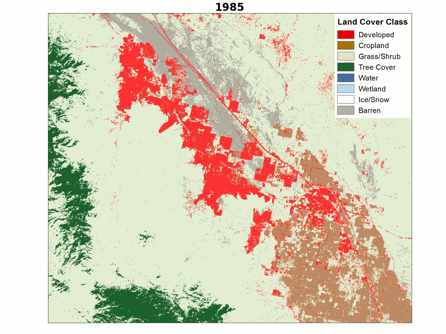
The USGS Land Change Monitoring, Assessment, and Projection (LCMAP) initiative aims to use that deep Landsat record to track change. That could mean abrupt changes like new development, loss of tree cover from wildfires or forest harvest, the conversion of land from grasslands to crops, or changes that play out over several years. The scientific approach used in LCMAP involves every high-quality Landsat pixel, going back to 1982.
LCMAP recently released its first collection of science products for the conterminous U.S. The annual products don’t just tell us what’s on the land year after year, but where and when that land might have changed during each year.
The LCMAP approach can help us track land cover dynamics that might be the result of events like hurricanes or fires, to public policies like the U.S. farm bill, to climate change and weather patterns, to invasive species, and much, much more.
USGS Research Geographers Jess Brown, who leads the initiative, and Jenn Rover, who leads LCMAP’s Applied Sciences, recent sat down to talk about the importance of LCMAP on the USGS EROS podcast Eyes on Earth.
What is LCMAP? Where did this idea come from and why did EROS decide to pursue it?
Jess Brown: LCMAP is all about characterizing, monitoring, and understanding change on the Earth’s surface. This idea really goes back a long time—we could go back to the beginning of Landsat, actually. We are harnessing the power of the Landsat archive as a record. Folks who work at EROS, primarily Dr. Tom Loveland and his colleagues, as well as Dr. Curtis Woodcock (of Boston University), Dr. Zhe Zhu (of University of Connecticut), and many others really helped spawn this idea that we could use this incredible archive to target change events and characterize the cover of the land’s surface.
What kinds of changes are we looking at? Are we just talking about leaves changing color or snow being on the ground where it wasn’t there before?
JB: We’re trying to target change in the land cover state or condition, something like a cropland cover to a developed cover, or a forested cover to cropland or grassland. It is different than just simply tracking differences in phenology or vegetation growth.
How does LCMAP use Landsat data to find change?
JB: We have reconditioned the (Landsat) archive into something called Analysis Ready Data (ARD), and this is essentially a super large data cube of observations through time. After we recondition the archive, we can use an approach called Continuous Change Detection and Classification (CCDC) to identify change events. We’re really thinking about the data as stacked up like a big layer cake, and we are running a vertical marker through that time stack. The change that (CCDC) finds could be a land cover change, or it could be a different kind of change, such as where drought has influenced the grass surface and it has dried substantially, or where a forest thinning event has occurred. You could have tree cover, but perhaps there are fewer trees or the forest had some kind of insect infestation. Those changes don’t initiate a land cover change, but CCDC finds them. So the first step in our process is just to find change. We run the land cover after we find the changes, so we can identify which changes actually led to a shift in land cover.
Why is it so important to understand how the land surface changes through space and time?
The referenced media source is missing and needs to be re-embedded.
Animation of land cover change in the area surrouding Disney World resorts in Florida, created using the LCMAP Primary Land Cover product.
JB: Land cover, as well as the other types of changes that we’re finding, is a lot more dynamic then we ever imagined. If we are not monitoring continuously, we are not going to be able to find that. What we can do with this approach, which we have never done before, is to actually identify the date within a year that we observed a change.
Sod if you see a change that is close to the date of a hurricane or drought, you could actually tie change to those events?
JB: That’s right. We have done that. This is still a work in progress, but we do see really strong evidence—especially with large change events such as those caused by hurricanes—that we can. I wouldn’t say we can pinpoint the exact date, but it is better than we’ve had before.
Jen Rover: That geographic region has a really high density of wetlands, so it is an interesting area to look at. Wetlands are very ephemeral. They change within a season. Using the information from the LCMAP change day product, I can actually go in and map when pixels within a wetland area changed, and what time of year they changed. I can ask “is this a wetland that has a lot of change in the spring? Does it change in summer or fall? Is it a combination?” And I can look at that through 33 years.
Why would you want to know how and when a wetland is changing?
JR: The U.S. government has done some mapping and inventorying of wetlands, and that started many decades ago. Those maps were originally created with aerial photography, so it was labor intensive. I am actually looking into how LCMAP can be used to identify areas that have had a lot of change. If we know there’s been a lot of change in certain areas, then maybe those areas are prioritized for (labor intensive) updates, rather than areas that haven’t had a lot of changes.
So updating those maps is about managing the area for wildlife or managing water use?
JR: It’s to understand, from a wetlands perspective, what types of ecosystem services are available. So part of it is understanding our resources, but wetlands are also protected by the Clean Water Act. So it’s important to know where they are so they’re not disturbed accidently or somehow drained when they’re expected to be a resource for our environment.
Is LCMAP done, or will there be updates in the coming years?
JR: Right now, the team is looking at how to update these products for 2018 and 2019. The thing about the methodology we are currently using is that we need the entire calendar year’s worth of Landsat data before we can run the model. It needs all the data, so we’ll lag a little behind each calendar year for that product development. In the future, the team is looking at different methodologies that we could use to monitor in a shorter timeframe. So let’s say if we know we expect to see drought conditions, we will be able to estimate what might happen on the landscape. We are only just starting to understand what we can learn about our country by tracking those changes and integrating climate, fire modeling, or other natural resources datasets.
There is a lot of information out there that’s released every day or every year: things like stream gage data or climate data. It seems like what you’re doing is trying to bring land cover, which is so time intensive to produce with Landsat data, into the fold as a more timely product. Is that right?
JB: Oh, yes. Absolutely. There are a lot of possibilities for the future for LCMAP. You mentioned (wetlands) management earlier. Providing this type of information on an annual basis for land managers is one of the things that we see as a big growth area.
What else can we look for from LCMAP in the future? Are you going to look at doing Alaska and Hawaii, for example?
JB: Annual updating is our first priority. But after that, we do plan to expand to Hawaii and Alaska. Hawaii is a little easier to tackle just because it’s a lot smaller. Alaska is a huge state. Those landscapes come with some challenges related to data quality, quantity and cloudiness, and cloudiness does affect our ability to find change. I would say one of our other big areas is our assessments capability. I like the expression “every pixel tells a story” but it’s more than that. Assessments is where we’ll really get to delve into understanding the products and what they are telling us about land surface change across our country.
LCMAP Collections ensure that all LCMAP science products are consistently processed and retain traceability of data quality provenance. Check out the links below to learn more about the differences between available LCMAP CONUS science product collections.
LCMAP Collections ensure that all LCMAP science products are consistently processed and retain traceability of data quality provenance. Check out the links below to learn more about the differences between available LCMAP CONUS science product collections.
Eyes on Earth is a podcast on remote sensing, Earth observation, land change and science, brought to you by the USGS Earth Resources Observation and Science (EROS) Center. In this episode, we learn about an exciting new initiative to track landscape change in the U.S.
Eyes on Earth Episode 29 – Tracking Landscape Change with LCMAP
Eyes on Earth is a podcast on remote sensing, Earth observation, land change and science, brought to you by the USGS Earth Resources Observation and Science (EROS) Center. In this episode, we learn about an exciting new initiative to track landscape change in the U.S.
Wetlands are dynamic in nature, growing and shrinking within and between years in ways far less predictable than croplands, forests, or established urban areas.
Wetlands are dynamic in nature, growing and shrinking within and between years in ways far less predictable than croplands, forests, or established urban areas.
Eyes on Earth Episode 29 – Tracking Landscape Change with LCMAP
The U.S. Geological Survey took a bold step toward documenting change across the landscape with the launch of the first Landsat satellite in 1972. Since then, it’s collected nearly five decades of imagery. But it takes more than just imagery to understand change. It takes time, effort—and serious computing horsepower.
The U.S. Geological Survey took a bold step toward documenting change across the landscape with the launch of the first Landsat satellite in 1972. Since then, it’s collected nearly five decades of imagery. But it takes more than just imagery to understand change. It takes time, effort—and serious computing horsepower.
Growing demands for temporally specific information on land surface change are fueling a new generation of maps and statistics that can contribute to understanding geographic and temporal patterns of change across large regions, provide input into a wide range of environmental modeling studies, clarify the drivers of change, and provide more timely information for land managers. To meet...
Authors
Jesslyn F. Brown, Heather J. Tollerud, Christopher P. Barber, Qiang Zhou, John L. Dwyer, James Vogelmann, Thomas Loveland, Curtis Woodcock, Stephen V. Stehman, Zhe Zhu, Bruce Pengra, Kelcy Smith, Josephine Horton, George Z. Xian, Roger F. Auch, Terry L. Sohl, Kristi L. Sayler, Alisa L. Gallant, Daniel Zelenak, Ryan R. Reker, Jennifer R. Rover
LCMAP Projects Possibilities for Future Land Cover Change
One of the key elements of the U.S. Geological Survey’s (USGS) bold new Land Change Monitoring, Assessment, and Projection (LCMAP) initiative is its...
LCMAP Collections ensure that all LCMAP science products are consistently processed and retain traceability of data quality provenance. Check out the links below to learn more about the differences between available LCMAP CONUS science product collections.
LCMAP Collections ensure that all LCMAP science products are consistently processed and retain traceability of data quality provenance. Check out the links below to learn more about the differences between available LCMAP CONUS science product collections.
Eyes on Earth is a podcast on remote sensing, Earth observation, land change and science, brought to you by the USGS Earth Resources Observation and Science (EROS) Center. In this episode, we learn about an exciting new initiative to track landscape change in the U.S.
Eyes on Earth Episode 29 – Tracking Landscape Change with LCMAP
Eyes on Earth is a podcast on remote sensing, Earth observation, land change and science, brought to you by the USGS Earth Resources Observation and Science (EROS) Center. In this episode, we learn about an exciting new initiative to track landscape change in the U.S.
Wetlands are dynamic in nature, growing and shrinking within and between years in ways far less predictable than croplands, forests, or established urban areas.
Wetlands are dynamic in nature, growing and shrinking within and between years in ways far less predictable than croplands, forests, or established urban areas.
Eyes on Earth Episode 29 – Tracking Landscape Change with LCMAP
The U.S. Geological Survey took a bold step toward documenting change across the landscape with the launch of the first Landsat satellite in 1972. Since then, it’s collected nearly five decades of imagery. But it takes more than just imagery to understand change. It takes time, effort—and serious computing horsepower.
The U.S. Geological Survey took a bold step toward documenting change across the landscape with the launch of the first Landsat satellite in 1972. Since then, it’s collected nearly five decades of imagery. But it takes more than just imagery to understand change. It takes time, effort—and serious computing horsepower.
Growing demands for temporally specific information on land surface change are fueling a new generation of maps and statistics that can contribute to understanding geographic and temporal patterns of change across large regions, provide input into a wide range of environmental modeling studies, clarify the drivers of change, and provide more timely information for land managers. To meet...
Authors
Jesslyn F. Brown, Heather J. Tollerud, Christopher P. Barber, Qiang Zhou, John L. Dwyer, James Vogelmann, Thomas Loveland, Curtis Woodcock, Stephen V. Stehman, Zhe Zhu, Bruce Pengra, Kelcy Smith, Josephine Horton, George Z. Xian, Roger F. Auch, Terry L. Sohl, Kristi L. Sayler, Alisa L. Gallant, Daniel Zelenak, Ryan R. Reker, Jennifer R. Rover
LCMAP Projects Possibilities for Future Land Cover Change
One of the key elements of the U.S. Geological Survey’s (USGS) bold new Land Change Monitoring, Assessment, and Projection (LCMAP) initiative is its...