U.S. flag

An official website of the United States government

Images

Browse images from a wide range of science topics covered by USGS. All items in this gallery are considered public domain unless otherwise noted.

Filter Total Items: 1610
Airport tower collapsed. Rubble, debris, metal, wood scattered about in middle. Corrugated siding buckled on side of photo.
Anchorage International Airport Tower

The control tower at Anchorage International Airport fell to the ground during the earthquake. It was a split-level structure that was seven stories high on one side and built of reinforced concrete.

The control tower at Anchorage International Airport fell to the ground during the earthquake. It was a split-level structure that was seven stories high on one side and built of reinforced concrete.

Snow covered ground with numerous large cracks in ground. Photo has labels for streets and "graben" area of earthquake.
L street slide annotated

Annotated photo of ake00346. Album caption: A subsidence trough (or graben) formed at the head of the "L" Street landslide in Anchorage during the earthquake. The slide block, which is the virtually unbroken ground tot he left of graben, moved to the left. The subsidence trough sank 7 to 10 feet in response to 11 feet of horizontal movement of the slide block.

Annotated photo of ake00346. Album caption: A subsidence trough (or graben) formed at the head of the "L" Street landslide in Anchorage during the earthquake. The slide block, which is the virtually unbroken ground tot he left of graben, moved to the left. The subsidence trough sank 7 to 10 feet in response to 11 feet of horizontal movement of the slide block.

Gray lidar elevating model. Annotated with L street, west12 avenue, staircase and white dashed lines marks scarp at top.
Pre-1964 Landslide Scarp

Arc-shaped bluff that many interpret to be evidence of landsliding during a pre-1964 earthquake of unknown age. The Frank and Maxine Reed Family Staircase at this stop was built to accommodate pedestrian traffic over a steep bluff along West Twelfth Avenue which is made discontinuous by the bluff. There was no sliding on this feature in 1964.

Arc-shaped bluff that many interpret to be evidence of landsliding during a pre-1964 earthquake of unknown age. The Frank and Maxine Reed Family Staircase at this stop was built to accommodate pedestrian traffic over a steep bluff along West Twelfth Avenue which is made discontinuous by the bluff. There was no sliding on this feature in 1964.

Black and white map showing damage. Has displacement of ground in feet and lateral displacement arrows. Scale 0 to 500 ft.
Buttress Park
Buttress Park
Buttress Park

This map shows the extent of ground disrupted by the Fourth Avenue Slide and some of the measured displacements. Much of this area north of Third Avenue has since been re-graded and reinforced. The North-facing slope dropping into Ship Creek has been reinforced at its toe with a buried gravel buttress, giving the park its name. 

This map shows the extent of ground disrupted by the Fourth Avenue Slide and some of the measured displacements. Much of this area north of Third Avenue has since been re-graded and reinforced. The North-facing slope dropping into Ship Creek has been reinforced at its toe with a buried gravel buttress, giving the park its name. 

Snow covered ground with hospital, water tower and other buildings. Arrows point to main scarp areas "sliding down slope."
Annotated Native Hospital landslide in Anchorage District, Cook Inlet Region, Alaska

Native Hospital landslide in Anchorage, showing graben and pressure ridge. The scar of an older landslide is transected by the slide of March 27. Photo lables the hospital and two areas of the main scarp on the 1964 landslide. 

Native Hospital landslide in Anchorage, showing graben and pressure ridge. The scar of an older landslide is transected by the slide of March 27. Photo lables the hospital and two areas of the main scarp on the 1964 landslide. 

Snow covered ground label/arrows pointing to main scarp. Other labels apartment building, St. Mary’s Residence, and streets.
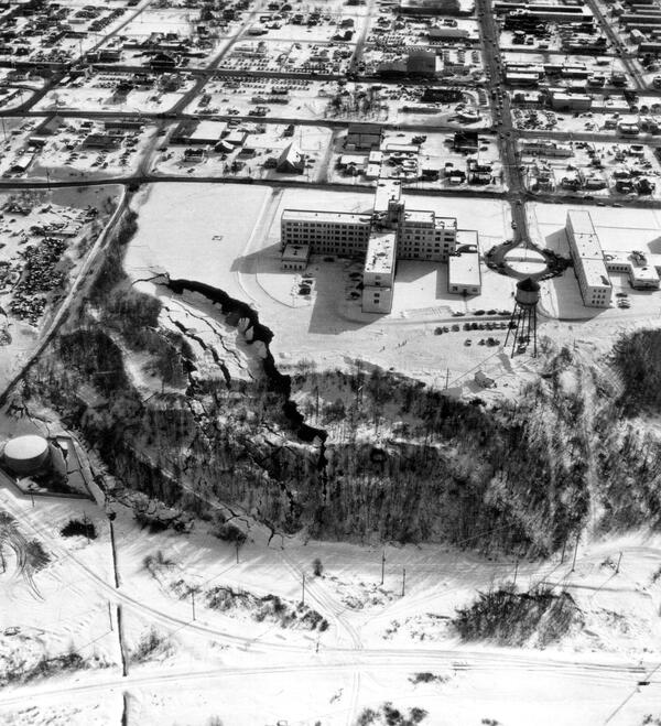
annotated St. Mary's Residence - Old Providence Hospital

1964 aerial photograph of St. Mary's Residence and the nearby Four Seasons Apartment Building (#25 on map), Anchorage, Alaska. copyright: Air Photo Tech - NV5 Geospatial. Original photo was used to make annotated version.

1964 aerial photograph of St. Mary's Residence and the nearby Four Seasons Apartment Building (#25 on map), Anchorage, Alaska. copyright: Air Photo Tech - NV5 Geospatial. Original photo was used to make annotated version.

Fairweather fault 1958

Low-level oblique aerial view of Fairweather fault. Photo taken east of North Dome, looking northwest, August 26, 1958.

Low-level oblique aerial view of Fairweather fault. Photo taken east of North Dome, looking northwest, August 26, 1958.

Black and white aerial view of a glacier.
South Cascade Glacier August 13th, 1958
A raft of sea otters near Cohen Island in Kachemak Bay, Alaska. Snow caped mountains in the background.
A raft of sea otters, Alaska

A raft of sea otters near Cohen Island in Kachemak Bay, Alaska. Sea otters rest together in groups called rafts. A raft can generally contain 10 to 100 sea otters. You will see either all male or all female with pups rafts.

A raft of sea otters near Cohen Island in Kachemak Bay, Alaska. Sea otters rest together in groups called rafts. A raft can generally contain 10 to 100 sea otters. You will see either all male or all female with pups rafts.

Graduate student on rock looking through a spotting scope on tripod used to observe sea otters.
Emily Reynolds watching sea otters through a spotting scope

Emily Reynolds, a graduate student, looks through a spotting scope. The student is watching sea otters in Kachemak Bay forage. USGS researchers spend hundreds of hours annually observing sea otter foraging behavior to document prey composition and energy recovery rates.

Emily Reynolds, a graduate student, looks through a spotting scope. The student is watching sea otters in Kachemak Bay forage. USGS researchers spend hundreds of hours annually observing sea otter foraging behavior to document prey composition and energy recovery rates.

Image: Sea Star Succumbing to Sea Star Wasting Disease
Sea Star Succumbing to Sea Star Wasting Disease

Unlike their smiling cartoon brethren on television, since 2013, real-life sea stars have been suffering from a wasting disease epidemic in which they lose limbs and literally disintegrate in a matter of days. 

Unlike their smiling cartoon brethren on television, since 2013, real-life sea stars have been suffering from a wasting disease epidemic in which they lose limbs and literally disintegrate in a matter of days. 

Image: Goose Roundup
Goose Roundup
Goose Roundup
Goose Roundup

Chevak youth help funnel Cackling Geese into holding pen for banding.

Chevak youth help funnel Cackling Geese into holding pen for banding.

Image: Old Chevak Goose Camp
Old Chevak Goose Camp

Old Chevak ancestral church reborn as research site in 1986 for 25 year cooperative banding program where Chevak youth worked with U.S. Geological Survey and U.S. Fish and Wildlife Service capturing and banding geese and swans along the Kashunuk River on Yukon-Kuskokwim Delta, Alaska.

Old Chevak ancestral church reborn as research site in 1986 for 25 year cooperative banding program where Chevak youth worked with U.S. Geological Survey and U.S. Fish and Wildlife Service capturing and banding geese and swans along the Kashunuk River on Yukon-Kuskokwim Delta, Alaska.

Was this page helpful?