


Sounds from a large herd of walruses resting on Alaskan shores of the Chukchi Sea recorded. Deep full barks and calls of individual walruses near the edge of the herd are audible over a continuous rhythmic humming sound that arises from the calls of tens of thousands of walrsues from deeper within the herd.
The USGS Alaska Science Center conducts long-term research on the Pacific walrus to provide scientific information to Department of Interior management agencies and Alaska Native co-management partners. In addition, the USGS Pacific walrus research program collaborates with the U.S. Fish and Wildlife Service (USFWS) and the State of Alaska’s Department of Fish and Game and Alaska Native co-management partners to deliver scientific products that advance knowledge of walrus ecology and the importance of walrus in northern ecosystems. Because addressing population-level questions requires collaboration between U.S. and Russian scientists, many USGS studies have relied on Russian partnership.
Return to Ecosystems >> Marine Ecosystems
Recorded Video Talk: Teamwork at the Point Lay Walrus Haulout Strait Science, February 2025
Recorded Video Talk: Teamwork at the Point Lay Walrus Haulout Strait Science, February 2025
Recorded Video Talk: 2024 Walrus Estimate - Strait Science, May 30 2024
Recorded Video Talk: 2024 Walrus Estimate - Strait Science, May 30 2024
Recorded Video Talk: Pacific Walruses: Responding to Change? Strait Science, April 2023
Recorded Video Talk: Pacific Walruses: Responding to Change? Strait Science, April 2023
Population dynamics
Media

Sources/Usage: Public Domain. View Media Details
Department of Interior partner agencies require information on Pacific walrus survival, reproduction, population abundance, and population trend to inform management decisions and address statutory responsibilities.
US and Russian partners conducted aerial surveys in 1975, 1976, 1980, 1985, and 1990 to estimate population abundance. In 2006, USGS collaborated with US Fish and Wildlife Service (USFWS) and Russian partners to estimate population abundance from an offshore aerial survey that accounted for the proportion of walruses that were in-water and therefore unavailable to be counted, and was the first to rigorously account for uncertainty in the population abundance estimate.
Because these offshore survey efforts resulted in large uncertainty in the estimated population size, development began on alternative abundance estimation methods. The USFWS has led an effort, with USGS support, to estimate Pacific walrus population abundance using genetic mark-recapture methods. USGS efforts developing methods to determine sex and age of walruses from remotely collected biopsies support this effort.
USGS developed methods to estimate regional population size at a large coastal haulout and has refined these methods through use of unoccupied aerial systems (UAS or survey drones) through support of the USGS National Uncrewed Systems Office to estimate the regional walrus abundance in the U.S. Chukchi Sea autumn waters during 2018 and 2019.
Age structure surveys provide information on population demographics required by USFWS statutory responsibilities under the Marine Mammal Protection Act (MMPA). In the 1950’s, F.H. Fay pioneered methods for collecting walrus sex and age structure data by observing facial and tusk characteristics. These methods were applied to collect age structure data on offshore surveys from 1981-1999 with Department of the Interior support. The State of Alaska’s Department of Fish and Game evaluated these methods and found them to provide invaluable information on population demographics.
USGS developed integrated population models that estimated Pacific walrus survival, reproduction, and population trend. These models used all available age structure and population survey data to estimate population parameters required by the MMPA. These models found the age structure data to strongly influence estimated population trends, prompting USGS and FWS with support from the Alaska Department of Fish and Game to collect additional age structure data during 2013 - 2017.
USGS is pursuing further age structure data collection beginning in 2023. Development of integrated population models has allowed USGS and collaborators to evaluate threats posed to the Pacific walrus population from climate related changes in the Arctic. For example, an increase in deaths of young walruses resulting from disturbances at large coastal haulouts can affect population trend.
Q&A: USGS and USFWS Focus on Co-Production
Q&A: USGS and USFWS Focus on Co-Production
Q&A: Vessel Cruise for Estimates of Pacific Walrus Demography
Q&A: Vessel Cruise for Estimates of Pacific Walrus Demography
Seasonal distribution and habitat use
Seasonal distribution and habitat use
Pacific walruses primarily consume invertebrates that live in bottom sediments of the shallow continental shelf waters that extend across the Bering and Chukchi seas. In response to the understanding that sea ice loss causes walruses to change their movement and foraging behavior in ways that may affect survival and reproduction, USGS has developed minimally invasive methods to track walruses with small satellite-linked tags and has collected behavior and movement data from walruses across the Bering and Chukchi seas in support of numerous studies.
These studies include correcting aerial survey estimates for walruses in-water and therefore unavailable to be counted; understanding how walruses move within their habitat relative to sea ice movement in the northern Bering Sea; identifying how they move relative to sea ice and benthic biomass distributions in the Bering, and Chukchi Seas; and understanding how their resting and foraging efforts change when summer sea ice disappears.
The tracking data have also revealed walrus foraging areas within the Chukchi Sea and contributed to a broader understanding of marine mammal seasonal distributions in the Pacific Arctic. The tracking data are currently being analyzed to better understand how Pacific walruses utilize the largest coastal haulout in northwestern Alaska.
Sources/Usage: Public Domain. View Media Details

Media

Sources/Usage: Public Domain. View Media Details
Monitoring large coastal haulouts
Walruses haul out of the water and rest between foraging bouts. They rest on sea ice when it is available but use land when waters are ice free.
- The Chukchi Sea continental shelf has been ice-free during most summers since 2007, and the seasonal duration of ice-free conditions will increase in the decades ahead.
- When walruses gather in large numbers to rest on shore at locations that are termed “haulouts”, they are at risk from large mortality events resulting from disturbances that cause stampedes.
- They are also at increased risk from any vessel spill events because walrus distributions are so densely concentrated at and around coastal haulouts.
- To reduce these risks, managers require an understanding of the distribution and occurrence of large coastal haulouts.
- USGS has partnered with the USFWS and a Russian collaborator to document the occurrence and distribution of Pacific walrus haulouts. USGS is supporting a revision of the Pacific Walrus Haulout Database in collaboration with USFWS.
USGS has developed methods to monitor walruses resting on shore through use of Earth observing satellite imagery. USGS is supporting local management of haulouts by providing satellite imagery analysis to local managers during the haulout season. USGS has worked with Russian partners to extend these methods at haulout sites with complex substrates and terrain and plans to continue this work at Alaskan study sites with State of Alaska, FWS and academic partners.
To support that effort, the USGS Advanced Research Computing center is using trail camera ground-truth imagery collected by partner agencies to teach deep neural networks to recognize walruses so they can more rapidly detect walruses remotely. USGS is also collaborating to automate interpretation of the walrus haulouts apparent in optical Earth observing imagery so that information can be transferred to management partners in real-time, and USGS has supported harmonization of aerial survey imagery collection efforts conducted in the U.S. and Russia so that haulout monitoring studies and results may be unified range-wide.
Drones for Science Videos
Drones for Science Videos
Walrus Carcass Survey
Walrus Carcass Survey
Walrus Carcass Survey
Walrus Calf Scavenged by Polar Bear
Walrus Calf Scavenged by Polar Bear
Walrus Calf Scavenged by Polar Bear
Consequences of shifting prey base and increased energetic demands
Media
Sources/Usage: Public Domain. View Media Details
The loss of sea ice has caused shifts in walrus space use, is forecasted to increase the energetic demands for lactating walruses and may cause changes to walrus prey. By coupling walrus behavior models with an understanding of the energy demands throughout the reproductive life of female walruses, USGS evaluated the energetic consequences of forecasted sea ice loss over the next century.
This study found that continued sea ice loss will increase walrus energetic demands, but there was uncertainty about the impact increased energetic demands might have on body condition and how that may affect reproduction rates. To understand how the walrus population may respond to the increased energetic demands, USGS is evaluating methods to monitor possible changes in walrus reproductive success over time as environmental conditions change.
Using information collected by Native Alaskan communities in the Bering Strait region, from captive walruses in zoos and aquaria, and from aerial imagery from drones at coastal haulouts, USGS is investigating different methods to monitor walrus body condition and how variation in body condition may affect female reproductive success.
In support of this study USGS has:
(1) Collaborated to determine how to reliably measure fat stores from harvested walruses
(2) Evaluated the condition and composition of walrus fat stores
(3) Collaborated to evaluate energetic costs for resting walruses across the range of reproductive conditions and across juvenile age-classes
(4) Collaborated to evaluate energetic cost of swimming, diving, and resting in water
(5) Explored the development of diving capabilities in young walruses.
Finally, the loss of sea ice may cause changes to walrus prey and understanding the consequences of a shift in the prey base requires methods to understand walrus diet. So, USGS developed non-invasive methods to monitor walrus diet.
Potential effects of increased vessel traffic
Potential effects of increased vessel traffic
Arctic marine mammals have historically had low exposure to vessel traffic and noise, but sea ice loss has increased accessibility of Arctic waters to vessels. Thus, Arctic vessel traffic is expected to increase, yet its effect on walruses is unknown.
Vessel exposure has the potential to change walrus population dynamics by altering how much time walruses use to rest, travel, and forage. Such changes may require walruses to consume more calories or reduce their energy stores which are needed to support growth, reproduction, and maintenance.
- The USGS conducted an initial study of effects of vessel exposure on Pacific walrus behavior in the Chukchi Sea using data from satellite-tagged walruses (collected by USGS, Russian collaborators, and the State of Alaska’s Department of Fish and Game) and vessel locations.
- Foraging walruses were no more likely to stop foraging and start traveling when they were within 17 km of vessels than when they were greater than 17 km from vessels.
- Due to the small number of walruses exposed to vessels at close distances, this study did not determine at what distance vessel exposure affects walrus behaviors; however, it provided an upper bound on the distance at which the vessels encountered may disturb foraging walruses.
- Furthermore, USGS developed extensive analytical methods that will help detect the effect of vessel exposure on walrus behavior when sufficient walrus tracking data are available with improved resolution. USGS also supported a study to evaluate walrus in-air
Sources/Usage: Public Domain. View Media Details

Stock Definition
The Marine Mammal Protection Act requires an understanding of whether there are distinct stocks within the Pacific walrus sub-species. Pacific walruses range across the shallow waters of the continental shelf that extends between Alaska and the Russian Far East.
Three distinct breeding areas are known to develop during the sea ice maximum season each spring:
- In the eastern Bering Sea of the outer Bristol Bay region
- South of Saint Lawrence Island in the central northern Bering Sea
- within the Gulf of Anadyr in the northwestern Bering Sea
USGS investigated whether these distinct breeding regions may result in distinct stocks that may merit separate management efforts.
Investigations based on signatures from heavy metal isotopes characteristic of the two western breeding regions suggested that walruses in these regions had distinct isotopic signatures, suggesting that each region hosted walruses that habitually returned to that region.
However, genetic characterization of walruses from the three breeding regions determined that walruses freely moved amongst breeding regions, indicating that the Pacific walrus sub-species may be considered as a single stock.
Below are other science projects associated with this project.

ASC Walrus Thematic Data Releases
ASC Walrus Thematic Data Releases. USGS publishes data and software to support Pacific walrus research and management. This page offers a location to find data and software products thematically organized under the headings of “satellite imagery” and “aerial imagery.”

Changing Arctic Ecosystems
Arctic regions of Alaska are important for cultural and economic sustainability and host a wide variety of wildlife species, many of which are of conservation and management interest to the U.S. Department of the Interior. The USGS and collaborators provide information about Arctic ecosystems that are used by Arctic residents, management agencies, and industry.

USGS Alaska Science Center Wildlife Tracking Data Collection
Understanding the short- and long-distance movements of wildlife is critical for a wide variety of ecological research questions and management decisions. Since the mid-1980s, the USGS Alaska Science Center has used information from telemetry devices on wildlife species to determine locations of animals throughout their annual cycles, understand patterns of habitat use, quantify time spent on...
Below are multimedia items associated with this project.
Filter Total Items: 53
Sounds from a large herd of walruses resting on Alaskan shores of the Chukchi Sea recorded. Deep full barks and calls of individual walruses near the edge of the herd are audible over a continuous rhythmic humming sound that arises from the calls of tens of thousands of walrsues from deeper within the herd.

Drones for Science: Walrus Calf Scavenged by Polar Bear
Drones for Science: Walrus Calf Scavenged by Polar BearThis is B-roll video collected during the fall of 2024 on the Alaskan shores of the Chukchi Sea.
Drones for Science: Walrus Calf Scavenged by Polar Bear
Drones for Science: Walrus Calf Scavenged by Polar BearThis is B-roll video collected during the fall of 2024 on the Alaskan shores of the Chukchi Sea.
Drone on beach
USGS uses small uncrewed aerial systems, also known as drones for science, to survey walrus herds and carcasses on remote Alaskan beaches. The USGS visual observer, Christina Ahlstrom, keeps her eyes on the survey drone while the remote pilot prepares it to survey the walrus herd that is visible in the distance behind her on the beach.
USGS uses small uncrewed aerial systems, also known as drones for science, to survey walrus herds and carcasses on remote Alaskan beaches. The USGS visual observer, Christina Ahlstrom, keeps her eyes on the survey drone while the remote pilot prepares it to survey the walrus herd that is visible in the distance behind her on the beach.

Walrus carcasses
Aerial survey drone prepared for flight positioned on the beach near walrus calf carcasses. When sea ice retreats from large regions of the Chukchi Sea large herds of female and young walruses come to shore to rest.
Aerial survey drone prepared for flight positioned on the beach near walrus calf carcasses. When sea ice retreats from large regions of the Chukchi Sea large herds of female and young walruses come to shore to rest.
Drones for Science: Walrus Carcass Survey
This is B-roll video collected during the fall of 2024 on the Alaskan shores of the Chukchi Sea.
This is B-roll video collected during the fall of 2024 on the Alaskan shores of the Chukchi Sea.

USGS flying drone
USGS is flying drones for science, small uncrewed areal systems (sUAS), to surveys walruses when they rest on shore. The sUAS makes minimal sound due it is broad wing and is flown high above the walrus herds to enables survey data collection with minimal risk to walruses.
USGS is flying drones for science, small uncrewed areal systems (sUAS), to surveys walruses when they rest on shore. The sUAS makes minimal sound due it is broad wing and is flown high above the walrus herds to enables survey data collection with minimal risk to walruses.

Two adult walrus carcasses
Two adult walrus carcasses on the beach observed during the summer after a large group of walruses had rested on shore. USGS is collaborating with the North Slope Borough Department of Wildlife Management to screen walruses for wildlife diseases and algal toxins. The University of Alaska Fairbanks is collaborating with USGS to validate drone survey metho
Two adult walrus carcasses on the beach observed during the summer after a large group of walruses had rested on shore. USGS is collaborating with the North Slope Borough Department of Wildlife Management to screen walruses for wildlife diseases and algal toxins. The University of Alaska Fairbanks is collaborating with USGS to validate drone survey metho

Community Flyer for USGS Walrus Carcass Surveys
This is a community flyer for distribution in Point Lay, Alaska, to alert community members of USGS activities in the area. A collaborative team of USGS, the North Slope Borough, University of Alaska Fairbanks, and Point Lay residents will assist in surveys of walrus carcasses at a remote coastal haulout that has been used by hundreds of thousands of walruses e
This is a community flyer for distribution in Point Lay, Alaska, to alert community members of USGS activities in the area. A collaborative team of USGS, the North Slope Borough, University of Alaska Fairbanks, and Point Lay residents will assist in surveys of walrus carcasses at a remote coastal haulout that has been used by hundreds of thousands of walruses e
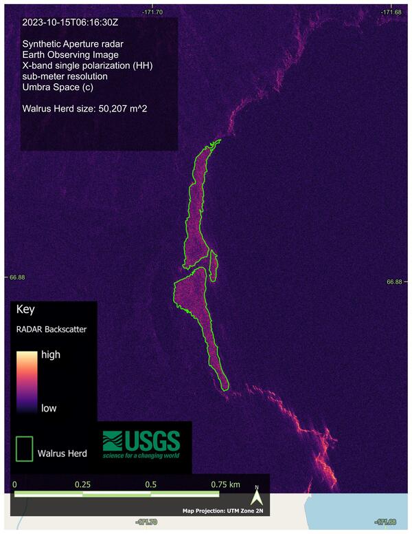
Outline of Pacific walrus herd at a large coastal haulout in Chukotka, Russia (Cape Serdtse Kamen) in 2023
Outline of Pacific walrus herd at a large coastal haulout in Chukotka, Russia (Cape Serdtse Kamen) in 2023This image shows the estimated outline and area (in square meters) occupied by Pacific walrus at a large coastal haulout in Chukotka Russia in 2023 at Cape Serdtse Kamen. The image is derived from images in 2022 and 2023 from a variety of Earth observing satellite imagery sources collected at known walrus coastal haulouts in Alaska and Chukotka, Russia.

Estimated area occupied by walrus at coastal haulouts in Alaska and Russia
Estimated area occupied by walrus at coastal haulouts in Alaska and RussiaThis image shows the estimated area (in square meters) occupied by Pacific walrus at eight coastal haulouts in northern Alaska and Chukotka Russia in 2023 (walrus were detected at two haulouts in 2023: Point Lay, Alaska and Cape Serdtse Kamen, Chukotka).

Walrus Plaque
The USGS Alaska Science Center is working with healthy, captive walruses in the U.S.
The USGS Alaska Science Center is working with healthy, captive walruses in the U.S.

Synthetic Aperture Radar (SAR) satellite images of a walrus haulout in Russia
Synthetic Aperture Radar (SAR) satellite images of a walrus haulout in RussiaFigure showing two Capella Space Synthetic Aperture Radar (SAR) satellite images of a walrus haulout in Russia during and after walrus occupancy. USGS has found that SAR imagery can detect walruses when they rest on shore in large numbers and is pursuing studies to understand how satellite imagery can support improved management of the Pacific walrus.

Synthetic Aperture Radar (SAR) satellite images of Pacific walruses
Synthetic Aperture Radar (SAR) satellite images of Pacific walrusesFigure comparing Synthetic Aperture Radar (SAR) satellite images of Pacific walruses on a terrestrial haulout near Point Lay, Alaska, as collected by four different SAR instruments possessing different spatial resolution capabilities (Sentinel-1, Radarsat-2, TerraSAR-X, and Capella Space).

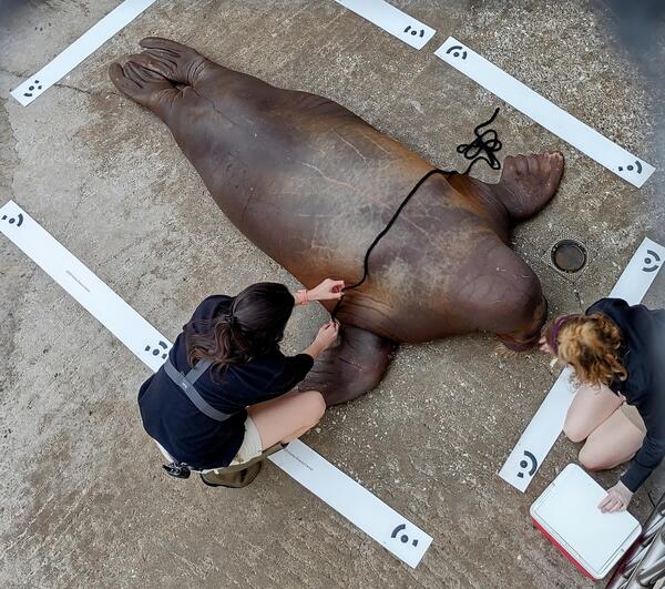
Marine mammal trainers measure a healthy female walrus
Marine mammal trainers measure a healthy female walrusIndianapolis Zoo marine mammal trainers, Erika Allen and Sydney Pitts, measure a healthy female walrus in support of a USGS study that seeks to develop methods to monitor walrus body condition from survey drones flown high above walruses where they rest on shore. With this new tool, USGS intends to examine the environmental factors that affect walrus body condi

Walruses resting on an ice floe
A group of Pacific walruses during summer in the Chukchi Sea
A group of Pacific walruses during summer in the Chukchi Sea

Close up of Pacific walruses jousting with their tusks, Chukchi Sea
Close up of Pacific walruses jousting with their tusks, Chukchi SeaPacific walruses jousting with their tusks on the eastern shore of the Chukchi Sea (Photo taken during USGS research efforts permitted under US Fish and Wildlife Service Permit No. MA801652-7.)

Pacific walruses hauled out on beach, Alaska
Pacific walruses resting on the beach of the eastern shore of the Chukchi Sea (Photo taken during USGS research efforts permitted under US Fish and Wildlife Service Permit No. MA801652-7.)
Pacific walruses resting on the beach of the eastern shore of the Chukchi Sea (Photo taken during USGS research efforts permitted under US Fish and Wildlife Service Permit No. MA801652-7.)

Pacific walruses resting in the water, Chukchi Sea, Alaska
Pacific walruses resting in the water, Chukchi Sea, AlaskaPacific walruses resting in the water on the eastern shore of the Chukchi Sea (Photo taken during USGS research efforts permitted under US Fish and Wildlife Service Permit No. MA801652-7.)

Pacific walruses hauled out on beach, Chukchi Sea, Alaska
Pacific walruses hauled out on beach, Chukchi Sea, AlaskaPacific walruses hauled out on the beach of the eastern shore of the Chukchi Sea (Photo taken during USGS research efforts permitted under US Fish and Wildlife Service Permit No. MA801652-7.)

Pacific walruses resting on beach, Chukchi Sea, Alaska
Pacific walruses resting on beach, Chukchi Sea, AlaskaPacific walruses resting on the beach of the eastern shore of the Chukchi Sea (Photo taken during USGS research efforts permitted under US Fish and Wildlife Service Permit No. MA801652-7.)
Pacific walruses resting on beach, Chukchi Sea, Alaska
Pacific walruses resting on beach, Chukchi Sea, AlaskaPacific walruses resting on the beach of the eastern shore of the Chukchi Sea (Photo taken during USGS research efforts permitted under US Fish and Wildlife Service Permit No. MA801652-7.)

Pacific walruses resting on beach, Chukchi Sea
Pacific walruses resting on the beach of the eastern shore of the Chukchi Sea (Photo taken during USGS research efforts permitted under US Fish and Wildlife Service Permit No. MA801652-7.)
Pacific walruses resting on the beach of the eastern shore of the Chukchi Sea (Photo taken during USGS research efforts permitted under US Fish and Wildlife Service Permit No. MA801652-7.)
The USGS Alaska Science Center conducts long-term research on the Pacific walrus to provide scientific information to Department of Interior management agencies and Alaska Native co-management partners. In addition, the USGS Pacific walrus research program collaborates with the U.S. Fish and Wildlife Service (USFWS) and the State of Alaska’s Department of Fish and Game and Alaska Native co-management partners to deliver scientific products that advance knowledge of walrus ecology and the importance of walrus in northern ecosystems. Because addressing population-level questions requires collaboration between U.S. and Russian scientists, many USGS studies have relied on Russian partnership.
Return to Ecosystems >> Marine Ecosystems
Recorded Video Talk: Teamwork at the Point Lay Walrus Haulout Strait Science, February 2025
Recorded Video Talk: Teamwork at the Point Lay Walrus Haulout Strait Science, February 2025
Recorded Video Talk: 2024 Walrus Estimate - Strait Science, May 30 2024
Recorded Video Talk: 2024 Walrus Estimate - Strait Science, May 30 2024
Recorded Video Talk: Pacific Walruses: Responding to Change? Strait Science, April 2023
Recorded Video Talk: Pacific Walruses: Responding to Change? Strait Science, April 2023
Population dynamics
Media
Sources/Usage: Public Domain. View Media Details
Department of Interior partner agencies require information on Pacific walrus survival, reproduction, population abundance, and population trend to inform management decisions and address statutory responsibilities.
US and Russian partners conducted aerial surveys in 1975, 1976, 1980, 1985, and 1990 to estimate population abundance. In 2006, USGS collaborated with US Fish and Wildlife Service (USFWS) and Russian partners to estimate population abundance from an offshore aerial survey that accounted for the proportion of walruses that were in-water and therefore unavailable to be counted, and was the first to rigorously account for uncertainty in the population abundance estimate.
Because these offshore survey efforts resulted in large uncertainty in the estimated population size, development began on alternative abundance estimation methods. The USFWS has led an effort, with USGS support, to estimate Pacific walrus population abundance using genetic mark-recapture methods. USGS efforts developing methods to determine sex and age of walruses from remotely collected biopsies support this effort.
USGS developed methods to estimate regional population size at a large coastal haulout and has refined these methods through use of unoccupied aerial systems (UAS or survey drones) through support of the USGS National Uncrewed Systems Office to estimate the regional walrus abundance in the U.S. Chukchi Sea autumn waters during 2018 and 2019.
Age structure surveys provide information on population demographics required by USFWS statutory responsibilities under the Marine Mammal Protection Act (MMPA). In the 1950’s, F.H. Fay pioneered methods for collecting walrus sex and age structure data by observing facial and tusk characteristics. These methods were applied to collect age structure data on offshore surveys from 1981-1999 with Department of the Interior support. The State of Alaska’s Department of Fish and Game evaluated these methods and found them to provide invaluable information on population demographics.
USGS developed integrated population models that estimated Pacific walrus survival, reproduction, and population trend. These models used all available age structure and population survey data to estimate population parameters required by the MMPA. These models found the age structure data to strongly influence estimated population trends, prompting USGS and FWS with support from the Alaska Department of Fish and Game to collect additional age structure data during 2013 - 2017.
USGS is pursuing further age structure data collection beginning in 2023. Development of integrated population models has allowed USGS and collaborators to evaluate threats posed to the Pacific walrus population from climate related changes in the Arctic. For example, an increase in deaths of young walruses resulting from disturbances at large coastal haulouts can affect population trend.
Q&A: USGS and USFWS Focus on Co-Production
Q&A: USGS and USFWS Focus on Co-Production
Q&A: Vessel Cruise for Estimates of Pacific Walrus Demography
Q&A: Vessel Cruise for Estimates of Pacific Walrus Demography
Seasonal distribution and habitat use
Seasonal distribution and habitat use
Pacific walruses primarily consume invertebrates that live in bottom sediments of the shallow continental shelf waters that extend across the Bering and Chukchi seas. In response to the understanding that sea ice loss causes walruses to change their movement and foraging behavior in ways that may affect survival and reproduction, USGS has developed minimally invasive methods to track walruses with small satellite-linked tags and has collected behavior and movement data from walruses across the Bering and Chukchi seas in support of numerous studies.
These studies include correcting aerial survey estimates for walruses in-water and therefore unavailable to be counted; understanding how walruses move within their habitat relative to sea ice movement in the northern Bering Sea; identifying how they move relative to sea ice and benthic biomass distributions in the Bering, and Chukchi Seas; and understanding how their resting and foraging efforts change when summer sea ice disappears.
The tracking data have also revealed walrus foraging areas within the Chukchi Sea and contributed to a broader understanding of marine mammal seasonal distributions in the Pacific Arctic. The tracking data are currently being analyzed to better understand how Pacific walruses utilize the largest coastal haulout in northwestern Alaska.
Sources/Usage: Public Domain. View Media Details
Media
Sources/Usage: Public Domain. View Media Details
Monitoring large coastal haulouts
Walruses haul out of the water and rest between foraging bouts. They rest on sea ice when it is available but use land when waters are ice free.
- The Chukchi Sea continental shelf has been ice-free during most summers since 2007, and the seasonal duration of ice-free conditions will increase in the decades ahead.
- When walruses gather in large numbers to rest on shore at locations that are termed “haulouts”, they are at risk from large mortality events resulting from disturbances that cause stampedes.
- They are also at increased risk from any vessel spill events because walrus distributions are so densely concentrated at and around coastal haulouts.
- To reduce these risks, managers require an understanding of the distribution and occurrence of large coastal haulouts.
- USGS has partnered with the USFWS and a Russian collaborator to document the occurrence and distribution of Pacific walrus haulouts. USGS is supporting a revision of the Pacific Walrus Haulout Database in collaboration with USFWS.
USGS has developed methods to monitor walruses resting on shore through use of Earth observing satellite imagery. USGS is supporting local management of haulouts by providing satellite imagery analysis to local managers during the haulout season. USGS has worked with Russian partners to extend these methods at haulout sites with complex substrates and terrain and plans to continue this work at Alaskan study sites with State of Alaska, FWS and academic partners.
To support that effort, the USGS Advanced Research Computing center is using trail camera ground-truth imagery collected by partner agencies to teach deep neural networks to recognize walruses so they can more rapidly detect walruses remotely. USGS is also collaborating to automate interpretation of the walrus haulouts apparent in optical Earth observing imagery so that information can be transferred to management partners in real-time, and USGS has supported harmonization of aerial survey imagery collection efforts conducted in the U.S. and Russia so that haulout monitoring studies and results may be unified range-wide.
Drones for Science Videos
Drones for Science Videos
Walrus Carcass Survey
Walrus Carcass Survey
Walrus Carcass Survey
Walrus Calf Scavenged by Polar Bear
Walrus Calf Scavenged by Polar Bear
Walrus Calf Scavenged by Polar Bear
Consequences of shifting prey base and increased energetic demands
Media
Sources/Usage: Public Domain. View Media Details
The loss of sea ice has caused shifts in walrus space use, is forecasted to increase the energetic demands for lactating walruses and may cause changes to walrus prey. By coupling walrus behavior models with an understanding of the energy demands throughout the reproductive life of female walruses, USGS evaluated the energetic consequences of forecasted sea ice loss over the next century.
This study found that continued sea ice loss will increase walrus energetic demands, but there was uncertainty about the impact increased energetic demands might have on body condition and how that may affect reproduction rates. To understand how the walrus population may respond to the increased energetic demands, USGS is evaluating methods to monitor possible changes in walrus reproductive success over time as environmental conditions change.
Using information collected by Native Alaskan communities in the Bering Strait region, from captive walruses in zoos and aquaria, and from aerial imagery from drones at coastal haulouts, USGS is investigating different methods to monitor walrus body condition and how variation in body condition may affect female reproductive success.
In support of this study USGS has:
(1) Collaborated to determine how to reliably measure fat stores from harvested walruses
(2) Evaluated the condition and composition of walrus fat stores
(3) Collaborated to evaluate energetic costs for resting walruses across the range of reproductive conditions and across juvenile age-classes
(4) Collaborated to evaluate energetic cost of swimming, diving, and resting in water
(5) Explored the development of diving capabilities in young walruses.
Finally, the loss of sea ice may cause changes to walrus prey and understanding the consequences of a shift in the prey base requires methods to understand walrus diet. So, USGS developed non-invasive methods to monitor walrus diet.
Potential effects of increased vessel traffic
Potential effects of increased vessel traffic
Arctic marine mammals have historically had low exposure to vessel traffic and noise, but sea ice loss has increased accessibility of Arctic waters to vessels. Thus, Arctic vessel traffic is expected to increase, yet its effect on walruses is unknown.
Vessel exposure has the potential to change walrus population dynamics by altering how much time walruses use to rest, travel, and forage. Such changes may require walruses to consume more calories or reduce their energy stores which are needed to support growth, reproduction, and maintenance.
- The USGS conducted an initial study of effects of vessel exposure on Pacific walrus behavior in the Chukchi Sea using data from satellite-tagged walruses (collected by USGS, Russian collaborators, and the State of Alaska’s Department of Fish and Game) and vessel locations.
- Foraging walruses were no more likely to stop foraging and start traveling when they were within 17 km of vessels than when they were greater than 17 km from vessels.
- Due to the small number of walruses exposed to vessels at close distances, this study did not determine at what distance vessel exposure affects walrus behaviors; however, it provided an upper bound on the distance at which the vessels encountered may disturb foraging walruses.
- Furthermore, USGS developed extensive analytical methods that will help detect the effect of vessel exposure on walrus behavior when sufficient walrus tracking data are available with improved resolution. USGS also supported a study to evaluate walrus in-air
Sources/Usage: Public Domain. View Media Details
Stock Definition
The Marine Mammal Protection Act requires an understanding of whether there are distinct stocks within the Pacific walrus sub-species. Pacific walruses range across the shallow waters of the continental shelf that extends between Alaska and the Russian Far East.
Three distinct breeding areas are known to develop during the sea ice maximum season each spring:
- In the eastern Bering Sea of the outer Bristol Bay region
- South of Saint Lawrence Island in the central northern Bering Sea
- within the Gulf of Anadyr in the northwestern Bering Sea
USGS investigated whether these distinct breeding regions may result in distinct stocks that may merit separate management efforts.
Investigations based on signatures from heavy metal isotopes characteristic of the two western breeding regions suggested that walruses in these regions had distinct isotopic signatures, suggesting that each region hosted walruses that habitually returned to that region.
However, genetic characterization of walruses from the three breeding regions determined that walruses freely moved amongst breeding regions, indicating that the Pacific walrus sub-species may be considered as a single stock.
Below are other science projects associated with this project.
ASC Walrus Thematic Data Releases
ASC Walrus Thematic Data Releases. USGS publishes data and software to support Pacific walrus research and management. This page offers a location to find data and software products thematically organized under the headings of “satellite imagery” and “aerial imagery.”
Changing Arctic Ecosystems
Arctic regions of Alaska are important for cultural and economic sustainability and host a wide variety of wildlife species, many of which are of conservation and management interest to the U.S. Department of the Interior. The USGS and collaborators provide information about Arctic ecosystems that are used by Arctic residents, management agencies, and industry.
USGS Alaska Science Center Wildlife Tracking Data Collection
Understanding the short- and long-distance movements of wildlife is critical for a wide variety of ecological research questions and management decisions. Since the mid-1980s, the USGS Alaska Science Center has used information from telemetry devices on wildlife species to determine locations of animals throughout their annual cycles, understand patterns of habitat use, quantify time spent on...
Below are multimedia items associated with this project.
Filter Total Items: 53
Large walrus herd resting on Alaskan shore
Sounds from a large herd of walruses resting on Alaskan shores of the Chukchi Sea recorded. Deep full barks and calls of individual walruses near the edge of the herd are audible over a continuous rhythmic humming sound that arises from the calls of tens of thousands of walrsues from deeper within the herd.
Sounds from a large herd of walruses resting on Alaskan shores of the Chukchi Sea recorded. Deep full barks and calls of individual walruses near the edge of the herd are audible over a continuous rhythmic humming sound that arises from the calls of tens of thousands of walrsues from deeper within the herd.
Drones for Science: Walrus Calf Scavenged by Polar Bear
Drones for Science: Walrus Calf Scavenged by Polar BearThis is B-roll video collected during the fall of 2024 on the Alaskan shores of the Chukchi Sea.
Drones for Science: Walrus Calf Scavenged by Polar Bear
Drones for Science: Walrus Calf Scavenged by Polar BearThis is B-roll video collected during the fall of 2024 on the Alaskan shores of the Chukchi Sea.
Drone on beach
USGS uses small uncrewed aerial systems, also known as drones for science, to survey walrus herds and carcasses on remote Alaskan beaches. The USGS visual observer, Christina Ahlstrom, keeps her eyes on the survey drone while the remote pilot prepares it to survey the walrus herd that is visible in the distance behind her on the beach.
USGS uses small uncrewed aerial systems, also known as drones for science, to survey walrus herds and carcasses on remote Alaskan beaches. The USGS visual observer, Christina Ahlstrom, keeps her eyes on the survey drone while the remote pilot prepares it to survey the walrus herd that is visible in the distance behind her on the beach.
Walrus carcasses
Aerial survey drone prepared for flight positioned on the beach near walrus calf carcasses. When sea ice retreats from large regions of the Chukchi Sea large herds of female and young walruses come to shore to rest.
Aerial survey drone prepared for flight positioned on the beach near walrus calf carcasses. When sea ice retreats from large regions of the Chukchi Sea large herds of female and young walruses come to shore to rest.
Drones for Science: Walrus Carcass Survey
This is B-roll video collected during the fall of 2024 on the Alaskan shores of the Chukchi Sea.
This is B-roll video collected during the fall of 2024 on the Alaskan shores of the Chukchi Sea.
USGS flying drone
USGS is flying drones for science, small uncrewed areal systems (sUAS), to surveys walruses when they rest on shore. The sUAS makes minimal sound due it is broad wing and is flown high above the walrus herds to enables survey data collection with minimal risk to walruses.
USGS is flying drones for science, small uncrewed areal systems (sUAS), to surveys walruses when they rest on shore. The sUAS makes minimal sound due it is broad wing and is flown high above the walrus herds to enables survey data collection with minimal risk to walruses.
Two adult walrus carcasses
Two adult walrus carcasses on the beach observed during the summer after a large group of walruses had rested on shore. USGS is collaborating with the North Slope Borough Department of Wildlife Management to screen walruses for wildlife diseases and algal toxins. The University of Alaska Fairbanks is collaborating with USGS to validate drone survey metho
Two adult walrus carcasses on the beach observed during the summer after a large group of walruses had rested on shore. USGS is collaborating with the North Slope Borough Department of Wildlife Management to screen walruses for wildlife diseases and algal toxins. The University of Alaska Fairbanks is collaborating with USGS to validate drone survey metho
Community Flyer for USGS Walrus Carcass Surveys
This is a community flyer for distribution in Point Lay, Alaska, to alert community members of USGS activities in the area. A collaborative team of USGS, the North Slope Borough, University of Alaska Fairbanks, and Point Lay residents will assist in surveys of walrus carcasses at a remote coastal haulout that has been used by hundreds of thousands of walruses e
This is a community flyer for distribution in Point Lay, Alaska, to alert community members of USGS activities in the area. A collaborative team of USGS, the North Slope Borough, University of Alaska Fairbanks, and Point Lay residents will assist in surveys of walrus carcasses at a remote coastal haulout that has been used by hundreds of thousands of walruses e
Outline of Pacific walrus herd at a large coastal haulout in Chukotka, Russia (Cape Serdtse Kamen) in 2023
Outline of Pacific walrus herd at a large coastal haulout in Chukotka, Russia (Cape Serdtse Kamen) in 2023This image shows the estimated outline and area (in square meters) occupied by Pacific walrus at a large coastal haulout in Chukotka Russia in 2023 at Cape Serdtse Kamen. The image is derived from images in 2022 and 2023 from a variety of Earth observing satellite imagery sources collected at known walrus coastal haulouts in Alaska and Chukotka, Russia.
Estimated area occupied by walrus at coastal haulouts in Alaska and Russia
Estimated area occupied by walrus at coastal haulouts in Alaska and RussiaThis image shows the estimated area (in square meters) occupied by Pacific walrus at eight coastal haulouts in northern Alaska and Chukotka Russia in 2023 (walrus were detected at two haulouts in 2023: Point Lay, Alaska and Cape Serdtse Kamen, Chukotka).
Walrus Plaque
The USGS Alaska Science Center is working with healthy, captive walruses in the U.S.
The USGS Alaska Science Center is working with healthy, captive walruses in the U.S.
Synthetic Aperture Radar (SAR) satellite images of a walrus haulout in Russia
Synthetic Aperture Radar (SAR) satellite images of a walrus haulout in RussiaFigure showing two Capella Space Synthetic Aperture Radar (SAR) satellite images of a walrus haulout in Russia during and after walrus occupancy. USGS has found that SAR imagery can detect walruses when they rest on shore in large numbers and is pursuing studies to understand how satellite imagery can support improved management of the Pacific walrus.
Synthetic Aperture Radar (SAR) satellite images of Pacific walruses
Synthetic Aperture Radar (SAR) satellite images of Pacific walrusesFigure comparing Synthetic Aperture Radar (SAR) satellite images of Pacific walruses on a terrestrial haulout near Point Lay, Alaska, as collected by four different SAR instruments possessing different spatial resolution capabilities (Sentinel-1, Radarsat-2, TerraSAR-X, and Capella Space).
Marine mammal trainers measure a healthy female walrus
Marine mammal trainers measure a healthy female walrusIndianapolis Zoo marine mammal trainers, Erika Allen and Sydney Pitts, measure a healthy female walrus in support of a USGS study that seeks to develop methods to monitor walrus body condition from survey drones flown high above walruses where they rest on shore. With this new tool, USGS intends to examine the environmental factors that affect walrus body condi
Walruses resting on an ice floe
A group of Pacific walruses during summer in the Chukchi Sea
A group of Pacific walruses during summer in the Chukchi Sea
Close up of Pacific walruses jousting with their tusks, Chukchi Sea
Close up of Pacific walruses jousting with their tusks, Chukchi SeaPacific walruses jousting with their tusks on the eastern shore of the Chukchi Sea (Photo taken during USGS research efforts permitted under US Fish and Wildlife Service Permit No. MA801652-7.)
Pacific walruses hauled out on beach, Alaska
Pacific walruses resting on the beach of the eastern shore of the Chukchi Sea (Photo taken during USGS research efforts permitted under US Fish and Wildlife Service Permit No. MA801652-7.)
Pacific walruses resting on the beach of the eastern shore of the Chukchi Sea (Photo taken during USGS research efforts permitted under US Fish and Wildlife Service Permit No. MA801652-7.)
Pacific walruses resting in the water, Chukchi Sea, Alaska
Pacific walruses resting in the water, Chukchi Sea, AlaskaPacific walruses resting in the water on the eastern shore of the Chukchi Sea (Photo taken during USGS research efforts permitted under US Fish and Wildlife Service Permit No. MA801652-7.)
Pacific walruses hauled out on beach, Chukchi Sea, Alaska
Pacific walruses hauled out on beach, Chukchi Sea, AlaskaPacific walruses hauled out on the beach of the eastern shore of the Chukchi Sea (Photo taken during USGS research efforts permitted under US Fish and Wildlife Service Permit No. MA801652-7.)
Pacific walruses resting on beach, Chukchi Sea, Alaska
Pacific walruses resting on beach, Chukchi Sea, AlaskaPacific walruses resting on the beach of the eastern shore of the Chukchi Sea (Photo taken during USGS research efforts permitted under US Fish and Wildlife Service Permit No. MA801652-7.)
Pacific walruses resting on beach, Chukchi Sea, Alaska
Pacific walruses resting on beach, Chukchi Sea, AlaskaPacific walruses resting on the beach of the eastern shore of the Chukchi Sea (Photo taken during USGS research efforts permitted under US Fish and Wildlife Service Permit No. MA801652-7.)
Pacific walruses resting on beach, Chukchi Sea
Pacific walruses resting on the beach of the eastern shore of the Chukchi Sea (Photo taken during USGS research efforts permitted under US Fish and Wildlife Service Permit No. MA801652-7.)
Pacific walruses resting on the beach of the eastern shore of the Chukchi Sea (Photo taken during USGS research efforts permitted under US Fish and Wildlife Service Permit No. MA801652-7.)