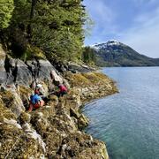
Barry Arm of Harriman Fjord, Prince William Sound, Alaska. Included is Barry Glacier and Cascade Glacier.
Christian E Zimmerman, Ph.D.
Actionable science to inform decision makers, managers, and the public
Professional Experience
2017 - Present Center Director, USGS Alaska Science Center, Anchorage, Alaska
2015 - 2017 Chief, Water and Interdisciplinary Studies Office, USGS, Alaska Science Center, Anchorage, Alaska
2002 - Present Chair Scientific and Technical Committee, Arctic-Yukon-Kuskokwim Sustainable Salmon Initiative, Anchorage, Alaska
2001-2015 Research Fish Biologist, Alaska Science Center, Anchorage, AK
2000 - 2001 Scientist, University of Washington, Seattle, Washington
1995 - 1997 Fishery Biologist, U.S. Forest Service Pacific Northwest Research Station, Corvallis, Oregon
1993 - 1995 Graduate Research Assistant, Oregon State University, Corvallis, Oregon
1992 Fishery Biologist, Thomas R. Payne and Associates/Pacific Land and Water Resources Consultants, Arcata, California
1991 Teaching Assistant, Humboldt State University, Arcata, California
1990 - 1991 Research Assistant, Institute of Limnology, Uppsala University, Uppsala, Sweden
1989 - 1990 Biological Technician, Redwood National Park, Arcata, California
Education and Certifications
Ph.D. 2000 Oregon State University, Corvallis, OR Fishery Science
M.S. 1996 Oregon State University, Corvallis, OR Fishery Science
B.S. 1992 Humboldt State University, Arcata, CA Fishery Biology
Science and Products
The Rusting of Arctic Rivers: Freshwater Ecosystems Respond to Rapidly Uptaking Metals
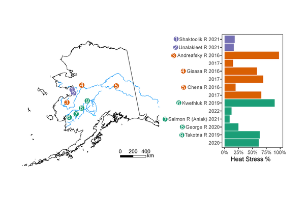
Assessing heat stress in migrating Yukon River Chinook Salmon
Outer Continental Shelf Program
Science Support Program and Quick Response Program
Collaborative Science for Priority Information Needs
Hydro-Ecology of Arctic Thawing (HEAT): Hydrology
Natural Resources Preservation Program
Arctic Lake Food Webs
Ecosystem Shifts in Arctic Seas
Lake Trout Biochronologies as Long-term Climate and Productivity Indicators in Alaska Lake Ecosystems
Primary Production Sources and Bottom-up Limitations in Nearshore Ecosystems
Hydro-Ecology of Arctic Thawing (HEAT): Ecology
Barry Arm of Harriman Fjord, Prince William Sound, Alaska. Included is Barry Glacier and Cascade Glacier.
Contents of the fyke net that was set in the lake near Atqasuk in 2016. All sticklebacks.
Collecting water quality data on the Pilgrim River. Types of measurements taken were on water temperature, dissolved oxygen, pH, and conductivity.
Randy Brown and Dan Young are setting nets to catch whitefish on Whitefish Lake in the Lake Clark National Park and Preserve.
Kijik Lake in Lake Clark National Park and Preserve, Alaska. USGS researchers study salmon ecology in cooperation with NPS.
Reflections of Tanalian Mountain and Hardenburg Bay in Lake Clark, Alaska. Near Port Alsworth.
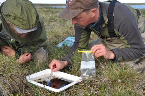
As part of the Changing Arctic Ecosystem project, two biologists sampling invertebrates near the Chipp River area.
Ice wedge polygons near the Chipp River area on the north slope of Alaska
An enhanced photo of camp on the north slope.
A clear Montana Bill Creek flowing into volcanically silted creek. Coho salmon are seen holding in the clear water area. Aerial surveys were done after the eruption of the Redoubt volcano to determine the condition of fish streams.
Cannery Creek on the west side of Cook Inlet, Alaska. Aerial surveys were done after the eruption of the Redoubt volcano to determine the condition of fish streams.
A coho salmon holding in Montana Bill Creek after the Redoubt volcano eruption.
A panorama of the Redoubt Volcano after the 2009 eruption and the Drift River delta in the foreground
Lower Drift River with tremendous amount of silt from the lahars. Aerial surveys were done after the eruption of the Redoubt volcano to determine the condition of fish streams.
Drift River on the west side of Cook Inlet, Alaska. Lahars from the eruption of Redoubt are evident. Surveys were done after the eruption of the Redoubt volcano to determine the condition of fish streams.
Drift River on the west side of Cook Inlet, Alaska. Lahars from the eruption of Redoubt are evident. Surveys were done after the eruption of the Redoubt volcano to determine the condition of fish streams. Alaska Department of Fish and Game had done surveys in this particular area and found coho salmon before the eruption.
View of the amount of lahar deposit from across the river and the amount of deposit the river has eroded out to sea in about 6 months. Surveys were done after the eruption of the Redoubt volcano to determine the condition of fish streams.
Aerial views of Tuxedni Bay on the west side of Cook Inlet, Alaska. This was during surveys for juvenile salmon distribution for the Anadromous Fish Catalog for the State of Alaska.
Aerial views of streams on the west side of Cook Inlet, Alaska. This was during surveys for juvenile salmon distribution for the Anadromous Fish Catalog for the State of Alaska.
Metal mobilization from thawing permafrost to aquatic ecosystems is driving rusting of Arctic streams
Differential heat shock protein responses in two species of Pacific salmon and their utility in identifying heat stress
Rivers of Arctic North America
Elodea mediates juvenile salmon growth by altering physical structure in freshwater habitats
Investigating effects of climate-induced changes in water temperature and diet on mercury concentrations in an Arctic freshwater forage fish
Fish ear stones offer climate change clues in Alaska's lakes
First juvenile Chum Salmon confirms successful reproduction for Pacific salmon in the North American Arctic
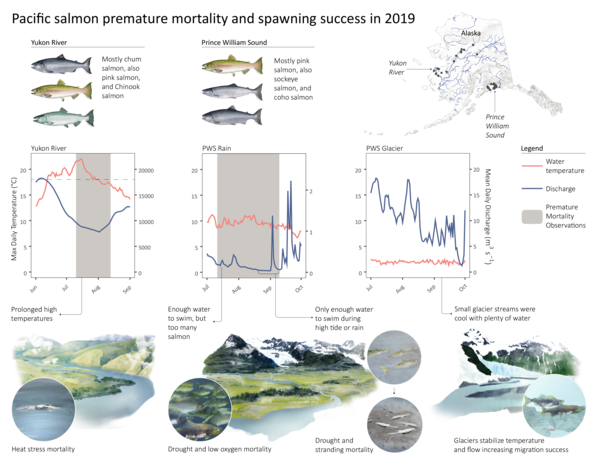
Premature mortality observations among Alaska’s Pacific salmon during record heat and drought in 2019
Circumpolar patterns of Arctic freshwater fish biodiversity: A baseline for monitoring
Diversity of diatoms, benthic macroinvertebrates, and fish varies in response to different environmental correlates in Arctic rivers across North America
Migration strategies supporting salmonids in Arctic Rivers: A case study of Arctic Cisco and Dolly Varden
The distribution of anadromy in steelhead / rainbow trout in the Eel River, northwestern California
Science and Products
The Rusting of Arctic Rivers: Freshwater Ecosystems Respond to Rapidly Uptaking Metals
Assessing heat stress in migrating Yukon River Chinook Salmon
Outer Continental Shelf Program
Science Support Program and Quick Response Program
Collaborative Science for Priority Information Needs
Hydro-Ecology of Arctic Thawing (HEAT): Hydrology
Natural Resources Preservation Program
Arctic Lake Food Webs
Ecosystem Shifts in Arctic Seas
Lake Trout Biochronologies as Long-term Climate and Productivity Indicators in Alaska Lake Ecosystems
Primary Production Sources and Bottom-up Limitations in Nearshore Ecosystems
Hydro-Ecology of Arctic Thawing (HEAT): Ecology
Barry Arm of Harriman Fjord, Prince William Sound, Alaska. Included is Barry Glacier and Cascade Glacier.
Contents of the fyke net that was set in the lake near Atqasuk in 2016. All sticklebacks.
Collecting water quality data on the Pilgrim River. Types of measurements taken were on water temperature, dissolved oxygen, pH, and conductivity.
Randy Brown and Dan Young are setting nets to catch whitefish on Whitefish Lake in the Lake Clark National Park and Preserve.
Kijik Lake in Lake Clark National Park and Preserve, Alaska. USGS researchers study salmon ecology in cooperation with NPS.
Reflections of Tanalian Mountain and Hardenburg Bay in Lake Clark, Alaska. Near Port Alsworth.
As part of the Changing Arctic Ecosystem project, two biologists sampling invertebrates near the Chipp River area.
Ice wedge polygons near the Chipp River area on the north slope of Alaska
An enhanced photo of camp on the north slope.
A clear Montana Bill Creek flowing into volcanically silted creek. Coho salmon are seen holding in the clear water area. Aerial surveys were done after the eruption of the Redoubt volcano to determine the condition of fish streams.
Cannery Creek on the west side of Cook Inlet, Alaska. Aerial surveys were done after the eruption of the Redoubt volcano to determine the condition of fish streams.
A coho salmon holding in Montana Bill Creek after the Redoubt volcano eruption.
A panorama of the Redoubt Volcano after the 2009 eruption and the Drift River delta in the foreground
Lower Drift River with tremendous amount of silt from the lahars. Aerial surveys were done after the eruption of the Redoubt volcano to determine the condition of fish streams.
Drift River on the west side of Cook Inlet, Alaska. Lahars from the eruption of Redoubt are evident. Surveys were done after the eruption of the Redoubt volcano to determine the condition of fish streams.
Drift River on the west side of Cook Inlet, Alaska. Lahars from the eruption of Redoubt are evident. Surveys were done after the eruption of the Redoubt volcano to determine the condition of fish streams. Alaska Department of Fish and Game had done surveys in this particular area and found coho salmon before the eruption.
View of the amount of lahar deposit from across the river and the amount of deposit the river has eroded out to sea in about 6 months. Surveys were done after the eruption of the Redoubt volcano to determine the condition of fish streams.
Aerial views of Tuxedni Bay on the west side of Cook Inlet, Alaska. This was during surveys for juvenile salmon distribution for the Anadromous Fish Catalog for the State of Alaska.
Aerial views of streams on the west side of Cook Inlet, Alaska. This was during surveys for juvenile salmon distribution for the Anadromous Fish Catalog for the State of Alaska.