Alaska Park Science
Learn about collaborative research between USGS and the National Park Service
Learn about collaborative research between USGS and the National Park Service
Rusting Rivers: Heavy Metals and Visible Color Changes
Geochemical Data Portal of the United States and Territories
Q&A: USGS Ecosystems Provides Objective Science to Manage Lands, Fish, and Wildlife
Alaska Critical Mineral Resource Assessments
Alaska has potential for a wide range of critical minerals including, but not limited to, graphite, lithium, tin, tungsten, rare earth elements, and platinum-group elements.
Alaska has potential for a wide range of critical minerals including, but not limited to, graphite, lithium, tin, tungsten, rare earth elements, and platinum-group elements.
Alaska Science Center
The mission of the Alaska Science Center (ASC) is to provide objective and timely data, information, and research findings about the earth and its flora and fauna to Federal, State, and local resource managers and the public to support sound decisions regarding natural resources, natural hazards, and ecosystems in Alaska and circumpolar regions. We have offices in Anchorage, Juneau, and Fairbanks.
Science Spotlight
Science Spotlight
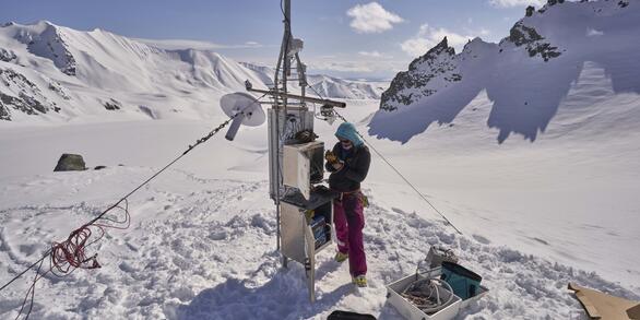
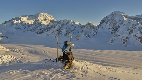
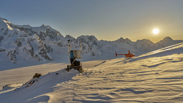
Glaciers and Landscape Change
The USGS Benchmark Glacier Project is aimed at solving complex scientific problems in snow and ice across North America to promote enhanced monitoring, analysis, and prediction of mountain glacier change.
News
USGS Scientist and National Weather Service and University of Alaska Southeast colleagues receive Alaska State Legislature Recognition for Response to Juneau’s annual Suicide Basin Outburst Floods
USGS Scientist and National Weather Service and University of Alaska Southeast colleagues receive Alaska State Legislature Recognition for Response to Juneau’s annual Suicide Basin Outburst Floods
What a Super El Niño could mean for Alaska’s seabirds, salmon, and seas
What a Super El Niño could mean for Alaska’s seabirds, salmon, and seas
EcoNews - Vol. 7 | Issue 2
EcoNews - Vol. 7 | Issue 2
Publications
Apatite (U-Th)/He thermochronology from Marsh Creek anticline reconciles Cenozoic and Holocene strain patterns and elucidates the Cenozoic canning displacement zone of Arctic Alaska Apatite (U-Th)/He thermochronology from Marsh Creek anticline reconciles Cenozoic and Holocene strain patterns and elucidates the Cenozoic canning displacement zone of Arctic Alaska
The northeastern Brooks Range is a vast fold-thrust belt that records the northernmost expression of Cenozoic deformation in Alaska, likely with complex dynamic linkages to distant tectonic elements. The principal focus of this manuscript is the Marsh Creek anticline (MCA), which is a large and recently active structure within the broader northeastern Brooks Range. The MCA is a complex...
Indicators of mercury concentration in Lake Trout: Can fish location and appearance provide information to anglers to reduce their exposure? Indicators of mercury concentration in Lake Trout: Can fish location and appearance provide information to anglers to reduce their exposure?
Objective People are exposed to mercury (Hg) through the consumption of fish. State and federal governments provide broad, often-generalized food safety guidance to reduce exposure; however, numerous rural fishing areas lack testing and location- or species-specific guidance. The aim of this study was to provide tangible, visible, or easily measured characteristics of Lake Trout...
Tringa flavipes (Lesser Yellowlegs) from separate breeding sites subdivides the Prairie Pothole Region in space and time during southbound migration Tringa flavipes (Lesser Yellowlegs) from separate breeding sites subdivides the Prairie Pothole Region in space and time during southbound migration
Some staging regions support multiple groups of the same migratory species, each of which may use the region differently. Characterizing the ways, in which separate groups use such regions can therefore help to identify vulnerabilities during this sensitive period of the annual cycle. The Prairie Pothole Region (PPR) is a massive wetland complex in the northern Great Plains of North...
Science

USGS Alaska Streamgage Datum to North American Vertical Datum of 1988 Conversion Table
To obtain stream water-surface elevation values in NAVD88 add the following conversion factor to gage height values.

Fish and Aquatic Ecology
Fish and aquatic habitats in Alaska support important commercial, sport, and subsistence fisheries and provide forage fish that support wildlife populations. The USGS Alaska Science Center conducts interdisciplinary research to inform local, state, federal, and international policy makers regarding conservation of fish, aquatic species, and their habitats. We work collaboratively with hydrologists...

Waterfowl Research
Scientists at the USGS Alaska Science Center have conducted research on waterfowl species (ducks, geese, and swans) in Alaska since the 1970s. Because Alaska is an international crossroads of migratory bird flyways, with millions of birds from Asia and North America breeding in Alaska each summer, USGS research has also taken place in adjacent countries (Russia, Japan, Canada, Mexico) and in the...


")