
Central Valley
Central Valley Hydrologic Model Version 2 (CVHM2)
Introducing the new USGS model representing the main components of California’s Central Valley water system.
Central Valley Regional Overview
California's Central Valley contains four main regions.
Central Valley Programs
USGS resources are being used to help manage the Central Valley aquifer system.
Competition for water resources is growing throughout California, particularly in the Central Valley. The Central Valley's population growth, along with anticipated reductions in Colorado River water deliveries, drought, and the ecological crisis in the Sacramento-San Joaquin Delta, have created an intense demand for water. Much of the research being conducted by the USGS in the Central Valley.
Land Subsidence Studies

Land subsidence is a gradual settling or sudden sinking of the Earth's surface due to subsurface movement of earth materials. The main cause of subsidence in California is groundwater pumping. The effects of subsidence include damage to buildings and infrastructure, increased flood risk in low-lying areas, and lasting damage to groundwater aquifers and aquatic ecosystems.
Central Valley Hydrologic Model
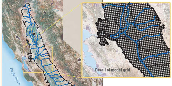
To help water managers understand how water moves through the aquifer system, predict water-supply, and address water competition, the USGS has developed hydrologic modeling tools. The original Central Valley Hydrologic Model (CVHM1) and the updated CVHM2 are detailed three-dimensional computer models of the Central Valley's hydrologic system.

Drought in California

Evaluation of Hydrodynamic Mixing in Keswick Reservoir, California

Soil Stratigraphy and Erosion Potential on the American and Sacramento Rivers

Sustainable Groundwater Management

Mercury

Pesticide Occurrence in California – Yolo Bypass Pesticide Analyses

California Oil, Gas, and Groundwater (COGG) Program

Delta-Mendota Canal: Using Groundwater Modeling to Analyze Land Subsidence

Delta-Mendota Canal: Evaluation of Groundwater Conditions and Land Subsidence

Land Subsidence Along the California Aqueduct

Simulating Land Subsidence
