
Remotely mapping stormwater facility footprints and storage volumes
Stormwater management practices are being used throughout the Chesapeake Bay watershed to reduce flood risks and pollutant loads, but consistent and comprehensive maps of these practices are often lacking. Stormwater managers often have incomplete information about the location and storage volume of stormwater facilities within their jurisdiction. Therefore, the USGS is working to develop artificial intelligence / machine learning (AI/ML) approaches to remotely map stormwater facilities for selected areas of the Chesapeake Bay watershed.
Problem
There is currently no regional, comprehensive database of stormwater management practices that includes stormwater storage estimates for the Chesapeake Bay watershed. Existing databases may only include stormwater facilities on public land, use inconsistent naming of facilities, and provide limited information on the size and storage capacity of each facility.
Objective
The objective of this project is to develop an AI/ML deep learning model to remotely map surface stormwater facilities within 30 small suburban and urban watersheds located in the Piedmont ecoregion of the Chesapeake Bay watershed. Each facility will have its footprint mapped and have an estimated stormwater storage volume based on high-resolution topographic data. Stormwater facilities to be mapped include swales, dry detention ponds, wet detention ponds, bioretention, and sand filters.
Approach
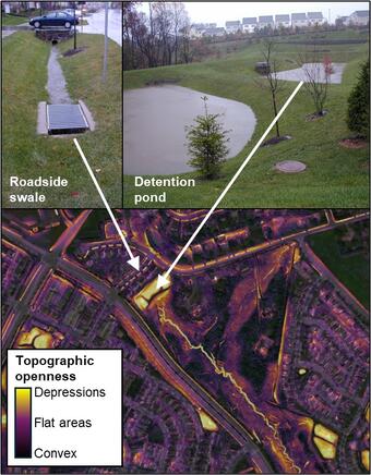
Existing high-resolution lidar-derived elevation data and imagery will be used to develop a set of predictor raster datasets as model inputs. A training dataset will be generated from existing municipal datasets and hand-digitized facility footprints. Predictor rasters and the training datasets will be input into an AI/ML deep learning model to map facility footprints. USGS will then develop an open-source workflow to estimate facility stormwater storage volume based on mapped footprints and elevation data. Results from the study will be published as a journal article and in a USGS data release.
Expected Benefits
Comprehensive spatial information about stormwater management practices can support stormwater managers, regional partners, and the scientific community. Stormwater managers can use information about the size and location of practices to evaluate existing facilities and plan future development. Regional partners can use remotely sensed practice data to track progress towards meeting Chesapeake Bay water-quality goals. The scientific community can use information about stormwater practices to evaluate and explain monitored streamflow and water-quality conditions. The work planned in this project will allow the USGS to evaluate how, in future years, remote sensing of stormwater practices could be expanded throughout the Chesapeake Bay watershed.

Understanding the Effects of Stormwater Management Practices on Water Quality and Flow

Fairfax County Water Resources Monitoring Network
Stormwater management practices are being used throughout the Chesapeake Bay watershed to reduce flood risks and pollutant loads, but consistent and comprehensive maps of these practices are often lacking. Stormwater managers often have incomplete information about the location and storage volume of stormwater facilities within their jurisdiction. Therefore, the USGS is working to develop artificial intelligence / machine learning (AI/ML) approaches to remotely map stormwater facilities for selected areas of the Chesapeake Bay watershed.
Problem
There is currently no regional, comprehensive database of stormwater management practices that includes stormwater storage estimates for the Chesapeake Bay watershed. Existing databases may only include stormwater facilities on public land, use inconsistent naming of facilities, and provide limited information on the size and storage capacity of each facility.
Objective
The objective of this project is to develop an AI/ML deep learning model to remotely map surface stormwater facilities within 30 small suburban and urban watersheds located in the Piedmont ecoregion of the Chesapeake Bay watershed. Each facility will have its footprint mapped and have an estimated stormwater storage volume based on high-resolution topographic data. Stormwater facilities to be mapped include swales, dry detention ponds, wet detention ponds, bioretention, and sand filters.
Approach
Existing high-resolution lidar-derived elevation data and imagery will be used to develop a set of predictor raster datasets as model inputs. A training dataset will be generated from existing municipal datasets and hand-digitized facility footprints. Predictor rasters and the training datasets will be input into an AI/ML deep learning model to map facility footprints. USGS will then develop an open-source workflow to estimate facility stormwater storage volume based on mapped footprints and elevation data. Results from the study will be published as a journal article and in a USGS data release.
Expected Benefits
Comprehensive spatial information about stormwater management practices can support stormwater managers, regional partners, and the scientific community. Stormwater managers can use information about the size and location of practices to evaluate existing facilities and plan future development. Regional partners can use remotely sensed practice data to track progress towards meeting Chesapeake Bay water-quality goals. The scientific community can use information about stormwater practices to evaluate and explain monitored streamflow and water-quality conditions. The work planned in this project will allow the USGS to evaluate how, in future years, remote sensing of stormwater practices could be expanded throughout the Chesapeake Bay watershed.
Understanding the Effects of Stormwater Management Practices on Water Quality and Flow