
Fairfax County Water Resources Monitoring Network
Fairfax Water Quality Dashboard
Need an easy way to access our monitoring data? This webtool allows users to explore and download our data quickly and easily.
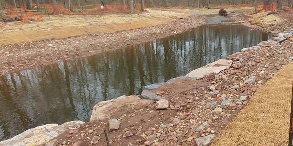
Lake Accotink Sedimentation Study
Studying erosion, deposition, and lake infilling in Accotink Creek and Lake Accotink
Latest Journal Article in Ecological Engineering:
Environmental tradeoffs of urban stream restoration in Fairfax County, Virginia
Latest Journal Article in Water:
A 10-Year Continuous Daily Simulation of Chloride Flux from a Suburban Watershed in Fairfax County, Virginia, USA
Interactive Narrative:
How and why are conditions changing in Fairfax streams?
Science Summary:
USGS Publications Summarize Water-Quality Trends and Drivers in Urban Streams After 10 Years of Monitoring in Fairfax County, Virginia
In recent years, hundreds of millions of dollars have been invested into the implementation of Best Management Practices in Fairfax County, Virginia, with the goal of improving water quality.
Research has demonstrated that best management practices are effective at smaller scales, but less information is available to document the effectiveness of these best management practices at the watershed scale - precisely the scale at which water-quality compliance and water-quality improvements are typically judged.
Answers are needed to support the development of watershed improvement plans, to motivate best management practice implementation, and to ensure the vitality of the cost-share programs that have supported these efforts.
This page describes the goals and methods of the Fairfax County Water Monitoring Program, as well as provides access to relevant publications and data generated by this effort.
Read the Latest Journal Article in Ecological Engineering:
Environmental tradeoffs of urban stream restoration in Fairfax County, Virginia
Applying the Stream Functions Pyramid framework to Flatlick Branch to evaluate restoration tradeoffs.
Latest Journal Article in Water:

A 10-Year Continuous Daily Simulation of Chloride Flux from a Suburban Watershed in Fairfax County, Virginia, USA
Modeling coupled water/chloride mass balance to gain insights into storage, residence time, and transport processes in the Long Branch urban watershed.
Explore our Interactive Narrative

How and why are conditions changing in Fairfax streams?
Don't have time to read the full report? This new interactive narrative summarizes our latest findings from the last decade of monitoring in a visually-engaging manner.

Table of Contents
Program Overview

Click here for interactive map.
Since 2007, the U.S. Geological Survey has partnered with Fairfax County to operate a water-resources monitoring program. The goals of this program are:
- To establish a baseline understanding of water-quality and streamflow conditions in Fairfax County streams.
- To determine sediment and nutrient loads and trends in those streams.
- To evaluate the relationships between the observed water quality conditions and the implementation of Best Management Practices in the monitored watersheds.
Currently, the county spends over \$26 million per year implementing best management practices to meet Chesapeake Bay and local 'Total Maximum Daily Load' requirements. Because of the costs associated with the implementation of these best management practices, as well as a genuine interest in improving ecological conditions, Fairfax County and other partner agencies are asking:
- Are these best management practices working?
- How long will it take for these practices to be effective?
- Are there more time-efficient, cost-effective methods for detecting improvements in water-quality and stream health?
Program Goals
To answer these questions this monitoring program will satisfy three primary objectives:
- Generate a long-term record of monitoring data to describe current water-quality (sediment and nutrients) and quantity (streamflow) conditions, trends in water-quality and quantity, and nutrient and sediment loads and yields.
- Evaluate relations between observed conditions and implementation of best management practices within the monitored watersheds.
- Expand the spatial representation of the network and the understanding gained using data collected at other less-intensively monitored watersheds.
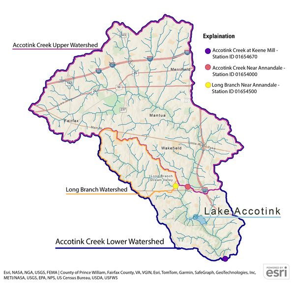
Long Branch Project Overview

In 2021, the USGS and Fairfax County began a long-term monitoring study to assess the Long Branch Central Watershed Management project.
Long Branch is a tributary of Accotink Creek in Fairfax County, Virginia. It is subject to Total Maximum Daily Load requirements to reduce sediment and chloride. This watershed, like the rest of the county, is also subject to the larger Chesapeake Bay sediment and nutrient Total Maximum Daily Load limits.
In response to these requirements, and in an effort to reduce sediment loading to Lake Accotink, Fairfax County developed the Long Branch Central Watershed Management project. This project seeks to meet Total Maximum Daily Load requirements, improve water quality, and generate ecological lift in Long Branch. This will be done through extensive stream restoration within Long Branch. An estimated 50%-75% of the stream length will be restored. Investments in this restoration effort are anticipated to approach \$40 million.
During this process, sound monitoring and scientific evaluation are needed to:
- Inform design and implementation of restoration efforts.
- Assess progress towards restoration goals.
- Inform future stormwater management and stream restoration efforts.
This effort compliments the highly successful county-wide water-resources monitoring program, which, since 2013, has included monitoring at the outlet of the Long Branch watershed.
Long Branch Goals
The goals of the Long Branch program are to collect and evaluate hydrologic, geomorphic, and water-quality data to inform and assess the Long Branch Central Watershed Management project. Specifically, the objectives are to:
- Quantify hydrologic responses to watershed-wide stream restoration, with particular focus on the role of floodplains.
- Quantify the effects of watershed-wide stream restoration on sediment and nutrient transport, with particular focus on the role of floodplains.
- Quantify loads and trends of major ions, sediment, and nutrients.
Lake Accotink and Accotink Creek Project Overview
Like many urban streams, Accotink Creek and its tributaries suffer from “urban stream syndrome,” which refers to a cycle of stream degradation resulting from land development. Since the 1950’s, the Accotink Creek watershed has undergone rapid urbanization prior to the implementation of Virginia stormwater management regulations, leading to significant sediment erosion and transport within the creek.
Sediments enter Accotink Creek from the erosion of upland soils, floodplains, and streambanks, gradually, and sometimes rapidly, being carried downstream. While some of this sediment reaches the Potomac River, a significant portion is trapped in Lake Accotink, leading to sediment buildup that causes the lake to shrink over time. The lake has been partially dredged twice to mitigate the effects of sedimentation and maintain its aesthetic as an asset to the community—first in 1985 and again in 2008. To preserve the lake at its current size, recurring dredging to maintain a lake at the current size may prove too expensive, too disruptive to adjacent communities, and potentially harmful to the natural resources of the lake and surrounding area. With a more detailed understanding about the rate of infill, feasible actions can be identified to maintain a smaller lake in a sustainable, equitable, and cost-effective manner.
In order to support informed decision-making, Fairfax County again partnered with the USGS to install a new monitoring site downstream of Lake Accotink. This new station, in addition to the existing monitoring sites at Long Branch and Accotink Creek above the lake,will be used to answer important questions about the Accotink Creek watershed and Lake Accotink, such as how much sediment is flowing into the lake and where this sediment is coming from. These data will be used by Fairfax County to help them assess future management scenarios for Lake Accotink.
Accotink Goals
The goals of the Lake Accotink project are to understand sedimentation rates in Lake Accotink and within the upper Accotink Creek watershed. Specifically, the objectives are to:
- Measure how much sediment is flowing into the lake each year.
- Measure how much sediment is leaving the lake each year.
- Calculate how much sediment is being trapped in Lake Accotink
- Identify areas in upper Accotink Creek that are a source of sediment
- Identify areas in upper Accotink Creek that trap sediment before it gets to the lake
- Monitor changes in channel shape of Accotink Creek
- Measure nitrogen, phosphorus, and major ions below Lake Accotink and calculate annual loads
Learn more at the Accotink Project webpage.

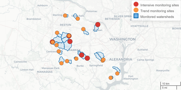
Monitoring
The Fairfax County Water Resources Monitoring Network uses multiple data collection approaches. This includes both 'intensive' and 'trend' monitoring stations as well as precipitation gages and floodplain monitoring stations. This tiered approach is an effective way of meeting program goals. This 21-station water quality monitoring network is regarded as the most robust urban-focused water-quality monitoring network in the entire Chesapeake Bay Watershed and is one of very few such networks in the nation.

This photo shows how streams can transport large amounts of suspended sediment during storm events.
Stream Monitoring Stations
Our network includes 6 intensive monitoring stations and 15 trend monitoring stations. Water samples are collected from all 21 sites monthly.
The 6 intensive monitoring stations collect as much data as possible so that we can get the clearest possible picture of current conditions in Fairfax County streams, and how these conditions are changing over time. These stations have instruments that measure water level, streamflow, turbidity, pH, specific conductance, dissolved oxygen, and water temperature continuously. Water samples are collected monthly, and nutrient and sediment concentrations are collected during select storm events. The intensive stations provide the data needed to assess changes in watershed hydrology and compute nutrient and sediment loads and trends.
While trends in water quality are tracked at all 21 stations, data collected monthly from the 15 trend monitoring stations add context to the data from the intensive stations and allow us to better evaluate how management activities and stream conditions may be linked.

Precipitation Gages
The 3 precipitation gages each collect measurements of rainfall volume and intensity every five minutes. These data help us understand changes in watershed hydrology at our 6 intensive monitoring stations, both by controlling for annual variability in rainfall, and allowing us to calculate additional hydrologic metrics.
Climate-induced increases in the intensity and frequency of storm events has caused flooding throughout Fairfax County. Flooding can cause damage to both public infrastructure and private property, and even lead to loss of life. In addition to supporting this program's goals, these rain gages can be used to develop and refine plans for flood preparedness and resilience, and may even be used as a tool for emergency responders to quickly react to extreme rainfall events.
In 2021 the first precipitation gage was installed at Little Run Elementary School, followed by gages at Churchill Road Park and Franklin Middle School in 2023. Together these stations provide good spatial coverage over the 21 watershed monitoring stations.
Floodplain Monitoring Stations
At 8 monitoring locations nested within the Long Branch watershed, additional monitoring elements provide the data needed to evaluate changes in sediment, nutrient, and chloride transport in response to an extensive stream restoration project. The monitoring design consists of 2 of the 6 intensive stations described previously, and 6 “floodplain” monitoring stations. At all 8 locations:
- Water level sensors are used to assess change in the duration, frequency, and magnitude/volume of floodplain inundation. Stream restoration designs typically aim to reconnect the channel and floodplain to promote overbank flow during moderate to large storm events. This design facilitates reductions in peak flow and in-channel water velocity to promote nutrient and sediment attenuation, groundwater recharge, and geomorphic stability. Evaluation of floodplain inundation characteristics is key to assessing the success of restoration practices at achieving these goals
- Grids of 20 clay pads in the surrounding floodplains of each station are used to quantify sediment and nutrient deposition (or erosion) rates on floodplain surfaces. Each fall, the depth of sediment accumulation over each clay pad is measured; and samples are collected for bulk density and nitrogen, phosphorus, and carbon concentrations. These data are used to measure annual floodplain deposition of sediment, nitrogen, phosphorus, and carbon, as well inform an annual sediment budget.
- Bank erosion is monitored along ~200 meter reaches at 4 of the 8 monitoring locations. Structure-from-motion (SfM) is used to provide reach-scale estimates of sediment flux from bank erosion. Measurements of bank erosion are also used to inform the annual sediment budget.
- In-channel sediment mapping is conducted each fall to estimate the amount of sediment stored in the channel bed. Characteristics and abundance of fine-grained depositional areas and point bars are made throughout the stream channel. The volume of each deposit is measured and a mass calculated.

Monitoring Elements
This monitoring network is designed to collect many types of data. These data fall into two general categories: continuous data and discrete data.
Continuous Data:
Conditions in urban streams can change quickly. High frequency data, collected multiple times per hour, are critical to understanding how streamflow and water quality conditions change in these highly dynamic urban streams.
- Our 6 intensive monitoring stations collect water level and streamflow measurements at 5-minute intervals. These data are made available on the USGS Water Date for the Nation website approximately 1 hour after the data are collected.
- A water quality monitoring sonde is deployed at each intensive monitoring station to measure turbidity, pH, specific conductance, dissolved oxygen, and water temperature every 15 minutes. Like streamflow, these water-quality data are also made available online approximately 1 hour after collection.
- Each precipitation gage collects measurements of rainfall volume and intensity every five minutes, which are made available online in near-real time.
Discrete Data:
Discrete data are collected when water samples or biological samples are taken at a monitoring site. Water samples are collected monthly at all 21 stations, and during storm events at the 6 intensive stations. Benthic macroinvertebrate samples are collected each spring, and fish samples every 3 years.
- Monthly sampling is conducted at all 21 stream monitoring locations. Samples are analyzed for suspended-sediment concentration, major ions, and various nutrients. Other data such as water temperature, turbidity, conductivity, pH, dissolved oxygen and stream stage are also collected.
- Each of the 6 intensive monitoring stations is equipped with an automated stream sampler to collect water samples during stormflow events. During such events, water levels in Fairfax streams can rise and fall too quickly for our researchers to get to each of the 6 sites and collect samples. Storm samples are valuable data points, so the automated samplers are programmed to collect multiple samples throughout the entire storm event. These samples are analyzed for both suspended sediments and nutrients, and in some instances, major ions.
Computed Data:
Nutrient and sediment concentrations cannot be continuously measured with equipment installed in the stream and can only be directly measured during monthly or storm sampling events. However, we often want to estimate how much nutrient or sediment loading is taking place over the course of a year. To do this, we use statistical models. By collecting stream metrics like turbidity, specific conductance, and streamflow we can estimate nitrogen, phosphorus, and sediment concentrations at any given time. These estimates of concentration, calculated every 15 minutes, are used to compute a load over a time period of interest, typically a year. This method, termed “surrogate regression modeling”, reduces the uncertainty in load estimates in small urban watersheds, where conditions can change rapidly.

Monitored Parameters
Learn more about what kinds of data we are collecting and what these data can tell us about the current and changing conditions in Fairfax County streams.
Continuous parameters:
Dissolved Oxygen: A measure of how much oxygen is dissolved in the water and available to living aquatic organisms.
pH: A measure of how acidic or basic water is.
Specific Conductance: The concentration of ions in a water sample. Specific conductance is a good proxy for salinity, as salts dissolve into ions in water. Specific conductance is often elevated in urban waters, and common sources of dissolved ions include de-icing road salts applied before winter storms and carbonates from concrete infrastructure. Specific conductance can also be used as a proxy for other dissolved constituents of interest such as nitrate and orthophosphate.
Stream Stage: The depth of the water in a pipe or channel. Stream stage and discharge are linked, so measuring stream stage allows researchers to construct models that let us estimate discharge at a given monitoring location.
Turbidity: A measure of water clarity. The more turbid the water, the less light can penetrate, and in very turbid waters, aquatic plants may die due to decreased light availability. High amounts of suspended sediment increase turbidity, so these measurements can be used as a proxy for total suspended solids or particulate bound nutrients such as phosphorus or organic nitrogen.
Water Temperature: Biological processes that affect water quality, such as microbe activity, can be influenced by water temperature.

During stormflow events, water levels can rise quickly and transport large amounts of nutrients and suspended sediment.
For this reason, sStorm sampling is an important aspect of data collection in small urban watersheds, as stormflow conditions can be very different from baseflow conditions.
Discrete parameters:
Nitrogen: A nutrient required for life, but in excess can degrade water quality and harm aquatic organisms. In addition to measuring total nitrogen, researchers also measured total Kjeldahl nitrogen (TKN), dissolved TKN, total particulate nitrogen, ammonia plus ammonium (NH3/NH4+), and nitrate plus nitrite (NO3-/NO2-).
- The inorganic forms of nitrogen (nitrate, nitrite, ammonia, and ammonium) are bioavailable, meaning that they can be used by plants in order to grow. These forms of nitrogen can therefore have a large impact on aquatic environments and are themselves toxic to aquatic animals in high enough concentrations.
- Total Kjeldahl Nitrogen (TKN) is a combined measurement of total organic nitrogen, ammonia, and ammonium, but excludes other inorganic forms of nitrogen such as nitrate and nitrite. Dissolved TKN is a measure of only the dissolved portion of these forms of nitrogen.
- Total Particulate Nitrogen is the combined measurement of all forms of nitrogen that are not dissolved and are instead associated with solid particles.
Phosphorus: Like nitrogen, phosphorus is a nutrient required for life, but in excessive amounts it is harmful to the environment. Excess phosphorus can lead to nutrient pollution, which can have devastating impacts on downstream aquatic ecosystems like Chesapeake Bay. In addition to total phosphorus, researchers also measured total dissolved phosphorus and total orthophosphate (PO4 3-), which is the primary dissolved inorganic form of phosphorus.
Total Suspended Sediment: the amount of fine sediment and coarse particles contained in a water sample. In addition to contributing to turbidity, fine suspended sediments can transport contaminants (nitrogen, phosphorus, metals, pesticides, poly-chlorinated biphenyls, and other organic contaminants) that are bound to these particles downstream.

Access Data
To query discrete data from all of our stations, click here.
To download data from our data releases, visit the data tab.
Intensive Monitoring Stations
To view the latest conditions at all five of our intensive monitoring stations side-by-side, click here.
| Station ID | Station Name | Station Type | Discrete Data | Continuous Data | Real-Time Water Quality |
|---|---|---|---|---|---|
| 01646305 | Dead Run at Whann Avenue near Mclean, VA | Intensive | Click Here | Click Here | Click Here |
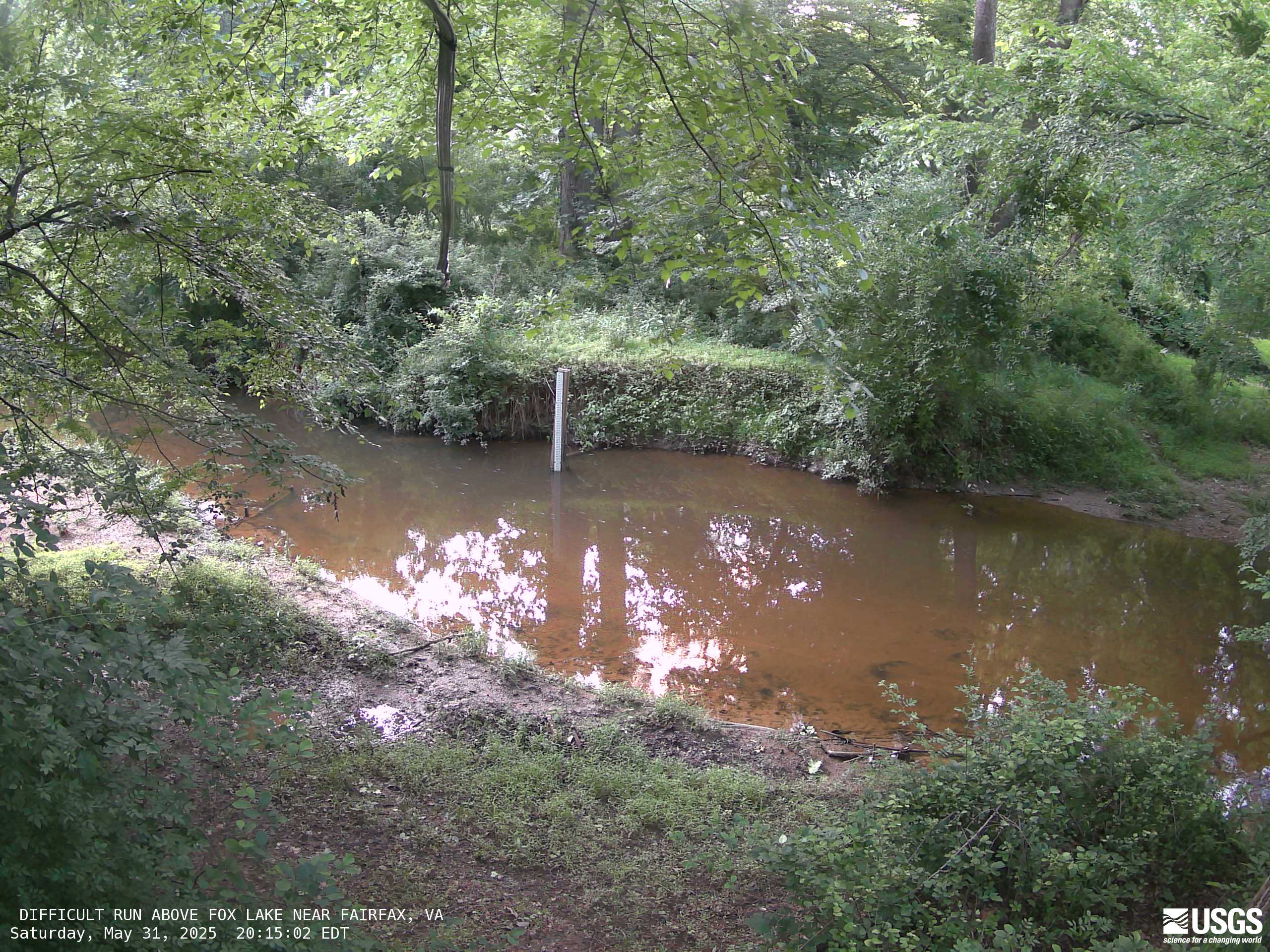
| 01645704 | Difficult Run above Fox Lake near Fairfax, VA | Intensive | Click Here | Click Here | Click Here |
| 01656903 | Flatlick Branch above Frog Branch at Chantilly, VA | Intensive | Click Here | Click Here | Click Here |
| 01645762 | S.F. Little Difficult Run above Mouth near Vienna, VA | Intensive | Click Here | Click Here | Click Here |
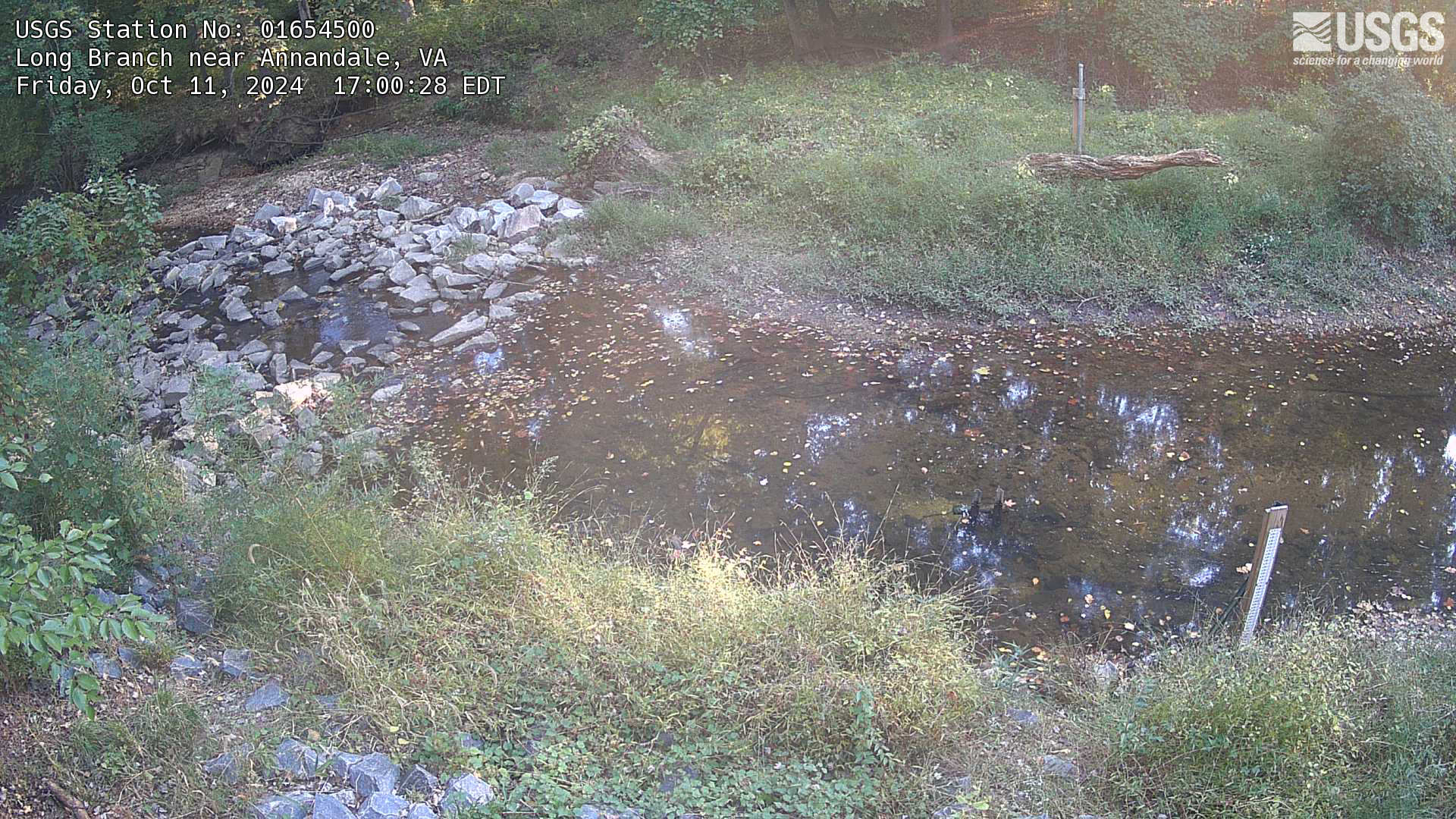
| 01654500 | Long Branch at Route 620 near Annandale, VA | Intensive | Click Here | Click Here | Click Here (HIVIS) |
| 01654107 | Long Branch at Olley Lane NR Fairfax, VA | Intensive, nested | Click Here | Click Here | Not Available |
Trend Monitoring Stations
| Station ID | Station Name | Station Type | Discrete Data |
|---|---|---|---|
| 0165694286 | Big Rocky Run at Stringfellow Road near Chantilly, VA | Trend | Click Here |
| 01645940 | Captain Hickory Run at Route 681 near Great Falls, VA | Trend | Click Here |
| 01657394 | Castle Creek at Newman Road at Clifton, VA | Trend | Click Here |
| 01653844 | Dogue Creek trib at Woodley Drive at Mount Vernon, VA | Trend | Click Here |
| 0165690673 | Frog Branch above Flatlick Branch at Chantilly, VA | Trend | Click Here |
| 0164425950 | Horsepen Run above Horsepen Run trib near Herndon, VA | Trend | Click Here |
| 01652789 | Indian Run at Bren Mar Drive at Alexandria, VA | Trend | Click Here |
| 01645745 | Little Difficult Run near Vienna, VA | Trend | Click Here |
| 01645844 | Old Courthouse Spring Branch near Vienna, VA | Trend | Click Here |
| 01653717 | Paul Spring Br above North Branch near Gum Springs, VA | Trend | Click Here |
| 01657322 | Popes Head Creek Tributary near Fairfax Station, VA | Trend | Click Here |
| 01655305 | Rabbit Branch trib above Lake Royal near Burke, VA | Trend | Click Here |
| 01644343 | Sugarland Run trib below Crayton Road near Herndon, VA | Trend | Click Here |
| 01652860 | Turkeycock Run at Edsall Road At Alexandria, VA | Trend | Click Here |
| 01657100 | Willow Springs Branch at Route 29 near Centreville, VA | Trend | Click Here |
Precipitation Monitoring Stations
| Station ID | Station Name | Station Type | Continuous Data |
|---|---|---|---|
| 384933077155801 | Met Stationn at Little Run Elem School at Fairfax, VA | Precipitation | Click Here |
| 385428077251801 | Met Station at Franklin M.S. at Chantilly, VA | Precipitation | Click Here |
| 385655077112201 | Met Station at Churchill Road Park at Mclean, VA | Precipitation | Click Here |
Bibliography
Check out our publications tab to read our latest reports sharing the results of this study.
Publications supported by data from this study:
- Bank-derived material dominates fluvial sediment in a suburban Chesapeake Bay watershed. River Research and Applications 2018;1-13; Cashman, M.J., Gellis, A., Sanisaca, L.G., Noe, G.B., Cogliandro, V., Baker, A.. 2018. https://doi.org/10.1002/rra.3325
- Spatial and temporal variation of stream chemistry associated with contrasting geology and land-use patterns in the Chesapeake Bay watershed - Summary of results from Smith Creek, Virginia; Upper Chester River, Maryland;Conewago Creek, Pennsylvania; and Difficult Run, Virginia, 2010 - 2013. U.S. Geological Survey Scientific Investigations Report 2016 - 5093, 211 p.; Hyer, K.E., Denver, J.M., Langland, M.J., Webber, J.S., Bohlke, J.K., Hively, W.D., and Clune, J.W.. 2016. https://doi.org/10.3133/sir20165093
- Storms, channel changes, and a sediment budget for an urban-suburban stream, Difficult Run, Virginia, USA. Geomorphology 278: 128 - 148; A.C. Gellis, M.K. Myers, G.B. Noe, C.R. Hupp, E.R. Schenk, L. Myers. 2017. https://doi.org/10.1016/j.geomorph.2016.10.031
- Recent and historic sediment dynamics along Difficult Run, a suburban Virginia Piedmont stream. Geomorphology 180 - 181: 156 - 169; Hupp, C.R., G.B. Noe, E.R. Schenk, and A.J. Benthem. 2013. https://doi.org/10.1016/j.geomorph.2012.10.007
- Effects of distributed and centralized stormwater best management practices and land cover on urban stream hydrology at the catchment scale; Loperfido, J.V., et al. 2014; https://doi.org/10.1016/j.jhydrol.2014.07.007
- Quantitative characterization of stream turbidity-discharge behavior using event loop shape modeling and power law parameter decorrelation; Water Resources Res., 50, 7766 - 7779, doi:10.1002/2014WR015417; Mather, A. L., and R. L. Johnson 2014, https://doi.org/10.1002/2014WR015417
- Developing a new stream metric for comparing stream function using a bank-floodplain sediment budget: a case study of three Piedmont streams; Earth Surface Processes and Landforms 38: 771 - 784, DOI: 10.1002/esp.3314; Schenk, E.R., C.R. Hupp, A. Gellis, and G.B. Noe. 2013. https://doi.org/10.1002/esp.3314
- Fluorescence-based source tracking of organic sediment in restored and unrestored urban streams; Limnology and Oceanography 60: 1439 - 1461, DOI: 10.1002/lno.10108; Larsen, L., J. Harvey, K. Skalak, and M. Goodman. 2015. https://doi.org/10.1002/lno.10108
- Fine particle retention within stream storage areas at base flow and in response to a storm event; Water Resources Research 53: 5690 - 5705, DOI: 10.1002/2016WR020202; Drummond, J. D., L. G. Larsen, R. González-Pinzón, A. I. Packman, and J. W. Harvey. 2017. https://doi.org/10.1002/2016WR020202
- Disrupted carbon cycling in restored and unrestored urban streams: Critical timescales and controls; Limnology and Oceanography 62: S160 - S182, DOI: 10.1002/lno.10613; Larsen, L. G. and Harvey, J. W.. 2017. https://doi.org/10.1002/lno.10613
Publications from efforts associated with this study:
- The influence of microtopography on soil nutrients in created mitigation wetlands; Restoration Ecology 17: 641 - 651; Moser, K., C. Ahn, and G. Noe. 2009. https://doi.org/10.1111/j.1526-100X.2008.00393.x
- Measurement of net nitrogen and phosphorus mineralization in wetland soils using a modification of the resin-core technique; Soil Science Society of America Journal 75: 760 - 770; Noe, G.B. 2011. https://doi.org/10.1111/j.1526-100X.2008.00393.x
- Interactions among hydrogeomorphology, vegetation, and nutrient biogeochemistry in floodplain ecosystems; In Shroder, J.F. (Editor in Chief), Butler, D.R., Hupp, C.R. (Volume Eds.), Treatise on Geomorphology, Vol. 12, Ecogeomorphology. Academic Press, San Diego, CA. pp. 307 - 321; Noe, G.B. 2013. https://doi.org/10.1016/B978-0-12-374739-6.00338-9
- Hydrogeomorphology influences soil nitrogen and phosphorus mineralization in floodplain wetlands; Ecosystems 16: 75 - 94; Noe, G.B., C.R. Hupp, and N.R. Rybicki. 2013. https://doi.org/10.1007/s10021-012-9597-0
- Science Summary—Sediment and Nutrient Trapping in the Flood Plain of Difficult Run, Virginia, and Implications for the Restoration of Chesapeake Bay; U.S. Geological Survey; Noe, G.B., C.R. Hupp, E.R. Schenk, and N.R. Rybicki. 2013. https://www.usgs.gov/centers/chesapeake-bay-activities/science/science-summary-sediment-and-nutrient-trapping-flood
- Simulating stream transport of nutrients in the Eastern United States, 2002, using a spatially-referenced regression model and 1:100,000 - scale hydrography, USGS Scientific Investigations Report 2013 - 5102; Hoos, A.B., R.B. Moore, A.M. Garcia, G.B. Noe, S.E. Terziotti, C.M. Johnston, and R.L. Dennis. 2013. https://doi.org/10.3133/sir20135102
- Characteristic length scales and time-averaged transport velocities of suspended sediment in the Mid-Atlantic Region; U.S.A. Water Resources Research 50: 1 - 12, doi:10.1002/2013WR014485; Pizzuto, J., E.R.Schenk, C.R. Hupp, A. Gellis, G. Noe, E. Williamson, D. Karwan, M. O’Neal, J. Marquardt, R. Aalto, D. Newbold. 2014. https://doi.org/10.1002/2013WR014485
- Soil greenhouse gas emissions and carbon budgeting in a short-hydroperiod floodplain wetland; JGR Biogeosciences. DOI: 10.1002/2014JG002817, Batson, J., G.B. Noe, C.R. Hupp, K.W. Krauss, N.B. Rybicki, and E.R. Schenk. 2015. https://doi.org/10.1002/2014JG002817
- Metformin and Other Pharmaceuticals Widespread in Wadeable Streams of the Southeastern United States; Environmental Science & Technology Letters. DOI: 10.1021/acs.estlett.6b00170, Bradley,P.M., C.A. Journey, D.T. Button, D.M. Carlisle, J.M. Clark, B.J. Mahler, N.Nakagaki, S.L. Qi, I.R. Waite, and P.C. VanMetre. 2015. https://doi.org/10.1021/acs.estlett.6b00170
Publications of interest for this study
- Costs of water quality goals under climate change in urbanizing watersheds: difficult run, Virginia. Journal of Water Resources Planning and Management, 143(9), 04017055. Giuffria, J. M., Bosch, D. J., Taylor, D. B., & Alamdari, N. 2017. https://doi.org/10.1061/(ASCE)WR.1943-5452.0000782
- Valuation of the flood attenuation ecosystem service in Difficult Run, VA, USA. Journal of Environmental Management, 231, 1056-1064.Lawrence, C. B., Pindilli, E. J., & Hogan, D. M. 2019. https://doi.org/10.1016/j.jenvman.2018.10.023
- Small forested watershed weathers effects of climate change better than a nearby urban watershed in Northern Virginia, USA. Hydrological Processes, 38(3), e15111. Porter, A. J., & Rice, K. C. 2024. https://doi.org/10.1002/hyp.15111
- Chemical composition of streams during low flow; Fairfax County, Virginia (No. 78-719). US Geological Survey. Larson, J. D. 1978. https://doi.org/10.3133/ofr78719
- 1983, Chemical quality of ground water in the Culpeper Basin, Virginia and Maryland; U.S. Geological Survey Miscellaneous Investigations Series Map I - 1313-D; Posner, A., and Zenone, C. https://doi.org/10.3133/i1313D
- 1983, Map showing geologic provinces, landforms, drainage basin characteristics, and flooding in Fairfax County and vicinity, Virginia; U.S. Geological Survey Miscellaneous Investigations Series Map I - 1421; Froelich, A.J., and Langer, W.H. https://doi.org/10.3133/i1421
- 1985a, Maps showing geologic terrane, drainage basins, overburden, and low flow of streams in Fairfax County and vicinity, Virginia; U.S. Geological Survey Miscellaneous Investigations Series Map I - 1561; Froelich, A.J., and Zenone, C. https://doi.org/10.3133/i1534
- 1985b, The relation of water quality to geology and land use changes in Fairfax County and vicinity, Virginia; U.S. Geological Survey Miscellaneous Investigations Series Map I - 1534; Froelich, A.J., and Zenone, C. https://doi.org/10.3133/i1561
- 1987, Low-flow characteristics and chemical quality of streams in the Culpeper geologic basin, Virginia and Maryland; U.S. Geological Survey Miscellaneous Investigations Series Map I - 1313-H; Lynch, D.D., E.H. Nuckels, and C. Zenone https://doi.org/10.3133/i1313H
- 9, Maps showing geologic and hydrologic factors affecting land-use planning in the Culpeper Basin, Virginia and Maryland; U.S. Geological Survey Miscellaneous Investigations Series Map I - 1313-J; Froelich, A.J. https://doi.org/10.3133/i1313J

Webcams


Photos


Read our most recent journal articles and Scientific Investigations Reports (SIRs) which share findings from this study, or read a summary of our scientific findings:
Latest Journal Article in Ecological Engineering:
Environmental tradeoffs of urban stream restoration in Fairfax County, Virginia
Latest Journal Article in Water:
A 10-Year Continuous Daily Simulation of Chloride Flux from a Suburban Watershed in Fairfax County, Virginia, USA
Explore our Interactive Narrative
How and why are conditions changing in Fairfax streams?
This interactive narrative summarizes a new U.S. Geological Survey report wherein monitoring data collected between 2007 and 2018 are used to provide insights into the changing water quality of urban streams in Fairfax County and the potential role of water-quality management practices.
Fairfax Current Conditions Dashboard
Need an easy way to access our monitoring data? This webtool allows users to explore and download our data quickly and easily.
The USGS Virginia and West Virginia Science Center collaborates with Fairfax County and other USGS programs to carry out this research.
Collaboration with other entities, including academic institutions, and local, state, and federal agencies, is welcome! To enquire about potential collaborations, please contact us using the button below:
Fairfax County Department of Public Works and Environmental Services

This research is jointly funded and operated by our partners at the Stormwater Planning division of the Fairfax County Department of Public Works and Environmental Services.
USGS Cooperative Water Program
Funding for this network was provided by the USGS Cooperative Matching Funds program, which supports joint projects with the USGS's state, regional, tribal, and local partners.
Other USGS Partners
The Fairfax Water Resources Monitoring Network benefits from extensive collaboration with other USGS programs, including:
In recent years, hundreds of millions of dollars have been invested into the implementation of Best Management Practices in Fairfax County, Virginia, with the goal of improving water quality.
Research has demonstrated that best management practices are effective at smaller scales, but less information is available to document the effectiveness of these best management practices at the watershed scale - precisely the scale at which water-quality compliance and water-quality improvements are typically judged.
Answers are needed to support the development of watershed improvement plans, to motivate best management practice implementation, and to ensure the vitality of the cost-share programs that have supported these efforts.
This page describes the goals and methods of the Fairfax County Water Monitoring Program, as well as provides access to relevant publications and data generated by this effort.
Read the Latest Journal Article in Ecological Engineering:
Environmental tradeoffs of urban stream restoration in Fairfax County, Virginia
Applying the Stream Functions Pyramid framework to Flatlick Branch to evaluate restoration tradeoffs.
Latest Journal Article in Water:
A 10-Year Continuous Daily Simulation of Chloride Flux from a Suburban Watershed in Fairfax County, Virginia, USA
Modeling coupled water/chloride mass balance to gain insights into storage, residence time, and transport processes in the Long Branch urban watershed.
Explore our Interactive Narrative
How and why are conditions changing in Fairfax streams?
Don't have time to read the full report? This new interactive narrative summarizes our latest findings from the last decade of monitoring in a visually-engaging manner.
Table of Contents
Program Overview
Click here for interactive map.
Since 2007, the U.S. Geological Survey has partnered with Fairfax County to operate a water-resources monitoring program. The goals of this program are:
- To establish a baseline understanding of water-quality and streamflow conditions in Fairfax County streams.
- To determine sediment and nutrient loads and trends in those streams.
- To evaluate the relationships between the observed water quality conditions and the implementation of Best Management Practices in the monitored watersheds.
Currently, the county spends over \$26 million per year implementing best management practices to meet Chesapeake Bay and local 'Total Maximum Daily Load' requirements. Because of the costs associated with the implementation of these best management practices, as well as a genuine interest in improving ecological conditions, Fairfax County and other partner agencies are asking:
- Are these best management practices working?
- How long will it take for these practices to be effective?
- Are there more time-efficient, cost-effective methods for detecting improvements in water-quality and stream health?
Program Goals
To answer these questions this monitoring program will satisfy three primary objectives:
- Generate a long-term record of monitoring data to describe current water-quality (sediment and nutrients) and quantity (streamflow) conditions, trends in water-quality and quantity, and nutrient and sediment loads and yields.
- Evaluate relations between observed conditions and implementation of best management practices within the monitored watersheds.
- Expand the spatial representation of the network and the understanding gained using data collected at other less-intensively monitored watersheds.
Long Branch Project Overview
In 2021, the USGS and Fairfax County began a long-term monitoring study to assess the Long Branch Central Watershed Management project.
Long Branch is a tributary of Accotink Creek in Fairfax County, Virginia. It is subject to Total Maximum Daily Load requirements to reduce sediment and chloride. This watershed, like the rest of the county, is also subject to the larger Chesapeake Bay sediment and nutrient Total Maximum Daily Load limits.
In response to these requirements, and in an effort to reduce sediment loading to Lake Accotink, Fairfax County developed the Long Branch Central Watershed Management project. This project seeks to meet Total Maximum Daily Load requirements, improve water quality, and generate ecological lift in Long Branch. This will be done through extensive stream restoration within Long Branch. An estimated 50%-75% of the stream length will be restored. Investments in this restoration effort are anticipated to approach \$40 million.
During this process, sound monitoring and scientific evaluation are needed to:
- Inform design and implementation of restoration efforts.
- Assess progress towards restoration goals.
- Inform future stormwater management and stream restoration efforts.
This effort compliments the highly successful county-wide water-resources monitoring program, which, since 2013, has included monitoring at the outlet of the Long Branch watershed.
Long Branch Goals
The goals of the Long Branch program are to collect and evaluate hydrologic, geomorphic, and water-quality data to inform and assess the Long Branch Central Watershed Management project. Specifically, the objectives are to:
- Quantify hydrologic responses to watershed-wide stream restoration, with particular focus on the role of floodplains.
- Quantify the effects of watershed-wide stream restoration on sediment and nutrient transport, with particular focus on the role of floodplains.
- Quantify loads and trends of major ions, sediment, and nutrients.
Lake Accotink and Accotink Creek Project Overview
Like many urban streams, Accotink Creek and its tributaries suffer from “urban stream syndrome,” which refers to a cycle of stream degradation resulting from land development. Since the 1950’s, the Accotink Creek watershed has undergone rapid urbanization prior to the implementation of Virginia stormwater management regulations, leading to significant sediment erosion and transport within the creek.
Sediments enter Accotink Creek from the erosion of upland soils, floodplains, and streambanks, gradually, and sometimes rapidly, being carried downstream. While some of this sediment reaches the Potomac River, a significant portion is trapped in Lake Accotink, leading to sediment buildup that causes the lake to shrink over time. The lake has been partially dredged twice to mitigate the effects of sedimentation and maintain its aesthetic as an asset to the community—first in 1985 and again in 2008. To preserve the lake at its current size, recurring dredging to maintain a lake at the current size may prove too expensive, too disruptive to adjacent communities, and potentially harmful to the natural resources of the lake and surrounding area. With a more detailed understanding about the rate of infill, feasible actions can be identified to maintain a smaller lake in a sustainable, equitable, and cost-effective manner.
In order to support informed decision-making, Fairfax County again partnered with the USGS to install a new monitoring site downstream of Lake Accotink. This new station, in addition to the existing monitoring sites at Long Branch and Accotink Creek above the lake,will be used to answer important questions about the Accotink Creek watershed and Lake Accotink, such as how much sediment is flowing into the lake and where this sediment is coming from. These data will be used by Fairfax County to help them assess future management scenarios for Lake Accotink.
Accotink Goals
The goals of the Lake Accotink project are to understand sedimentation rates in Lake Accotink and within the upper Accotink Creek watershed. Specifically, the objectives are to:
- Measure how much sediment is flowing into the lake each year.
- Measure how much sediment is leaving the lake each year.
- Calculate how much sediment is being trapped in Lake Accotink
- Identify areas in upper Accotink Creek that are a source of sediment
- Identify areas in upper Accotink Creek that trap sediment before it gets to the lake
- Monitor changes in channel shape of Accotink Creek
- Measure nitrogen, phosphorus, and major ions below Lake Accotink and calculate annual loads
Learn more at the Accotink Project webpage.
Monitoring
The Fairfax County Water Resources Monitoring Network uses multiple data collection approaches. This includes both 'intensive' and 'trend' monitoring stations as well as precipitation gages and floodplain monitoring stations. This tiered approach is an effective way of meeting program goals. This 21-station water quality monitoring network is regarded as the most robust urban-focused water-quality monitoring network in the entire Chesapeake Bay Watershed and is one of very few such networks in the nation.
This photo shows how streams can transport large amounts of suspended sediment during storm events.
Stream Monitoring Stations
Our network includes 6 intensive monitoring stations and 15 trend monitoring stations. Water samples are collected from all 21 sites monthly.
The 6 intensive monitoring stations collect as much data as possible so that we can get the clearest possible picture of current conditions in Fairfax County streams, and how these conditions are changing over time. These stations have instruments that measure water level, streamflow, turbidity, pH, specific conductance, dissolved oxygen, and water temperature continuously. Water samples are collected monthly, and nutrient and sediment concentrations are collected during select storm events. The intensive stations provide the data needed to assess changes in watershed hydrology and compute nutrient and sediment loads and trends.
While trends in water quality are tracked at all 21 stations, data collected monthly from the 15 trend monitoring stations add context to the data from the intensive stations and allow us to better evaluate how management activities and stream conditions may be linked.
Precipitation Gages
The 3 precipitation gages each collect measurements of rainfall volume and intensity every five minutes. These data help us understand changes in watershed hydrology at our 6 intensive monitoring stations, both by controlling for annual variability in rainfall, and allowing us to calculate additional hydrologic metrics.
Climate-induced increases in the intensity and frequency of storm events has caused flooding throughout Fairfax County. Flooding can cause damage to both public infrastructure and private property, and even lead to loss of life. In addition to supporting this program's goals, these rain gages can be used to develop and refine plans for flood preparedness and resilience, and may even be used as a tool for emergency responders to quickly react to extreme rainfall events.
In 2021 the first precipitation gage was installed at Little Run Elementary School, followed by gages at Churchill Road Park and Franklin Middle School in 2023. Together these stations provide good spatial coverage over the 21 watershed monitoring stations.
Floodplain Monitoring Stations
At 8 monitoring locations nested within the Long Branch watershed, additional monitoring elements provide the data needed to evaluate changes in sediment, nutrient, and chloride transport in response to an extensive stream restoration project. The monitoring design consists of 2 of the 6 intensive stations described previously, and 6 “floodplain” monitoring stations. At all 8 locations:
- Water level sensors are used to assess change in the duration, frequency, and magnitude/volume of floodplain inundation. Stream restoration designs typically aim to reconnect the channel and floodplain to promote overbank flow during moderate to large storm events. This design facilitates reductions in peak flow and in-channel water velocity to promote nutrient and sediment attenuation, groundwater recharge, and geomorphic stability. Evaluation of floodplain inundation characteristics is key to assessing the success of restoration practices at achieving these goals
- Grids of 20 clay pads in the surrounding floodplains of each station are used to quantify sediment and nutrient deposition (or erosion) rates on floodplain surfaces. Each fall, the depth of sediment accumulation over each clay pad is measured; and samples are collected for bulk density and nitrogen, phosphorus, and carbon concentrations. These data are used to measure annual floodplain deposition of sediment, nitrogen, phosphorus, and carbon, as well inform an annual sediment budget.
- Bank erosion is monitored along ~200 meter reaches at 4 of the 8 monitoring locations. Structure-from-motion (SfM) is used to provide reach-scale estimates of sediment flux from bank erosion. Measurements of bank erosion are also used to inform the annual sediment budget.
- In-channel sediment mapping is conducted each fall to estimate the amount of sediment stored in the channel bed. Characteristics and abundance of fine-grained depositional areas and point bars are made throughout the stream channel. The volume of each deposit is measured and a mass calculated.
Monitoring Elements
This monitoring network is designed to collect many types of data. These data fall into two general categories: continuous data and discrete data.
Continuous Data:
Conditions in urban streams can change quickly. High frequency data, collected multiple times per hour, are critical to understanding how streamflow and water quality conditions change in these highly dynamic urban streams.
- Our 6 intensive monitoring stations collect water level and streamflow measurements at 5-minute intervals. These data are made available on the USGS Water Date for the Nation website approximately 1 hour after the data are collected.
- A water quality monitoring sonde is deployed at each intensive monitoring station to measure turbidity, pH, specific conductance, dissolved oxygen, and water temperature every 15 minutes. Like streamflow, these water-quality data are also made available online approximately 1 hour after collection.
- Each precipitation gage collects measurements of rainfall volume and intensity every five minutes, which are made available online in near-real time.
Discrete Data:
Discrete data are collected when water samples or biological samples are taken at a monitoring site. Water samples are collected monthly at all 21 stations, and during storm events at the 6 intensive stations. Benthic macroinvertebrate samples are collected each spring, and fish samples every 3 years.
- Monthly sampling is conducted at all 21 stream monitoring locations. Samples are analyzed for suspended-sediment concentration, major ions, and various nutrients. Other data such as water temperature, turbidity, conductivity, pH, dissolved oxygen and stream stage are also collected.
- Each of the 6 intensive monitoring stations is equipped with an automated stream sampler to collect water samples during stormflow events. During such events, water levels in Fairfax streams can rise and fall too quickly for our researchers to get to each of the 6 sites and collect samples. Storm samples are valuable data points, so the automated samplers are programmed to collect multiple samples throughout the entire storm event. These samples are analyzed for both suspended sediments and nutrients, and in some instances, major ions.
Computed Data:
Nutrient and sediment concentrations cannot be continuously measured with equipment installed in the stream and can only be directly measured during monthly or storm sampling events. However, we often want to estimate how much nutrient or sediment loading is taking place over the course of a year. To do this, we use statistical models. By collecting stream metrics like turbidity, specific conductance, and streamflow we can estimate nitrogen, phosphorus, and sediment concentrations at any given time. These estimates of concentration, calculated every 15 minutes, are used to compute a load over a time period of interest, typically a year. This method, termed “surrogate regression modeling”, reduces the uncertainty in load estimates in small urban watersheds, where conditions can change rapidly.
Monitored Parameters
Learn more about what kinds of data we are collecting and what these data can tell us about the current and changing conditions in Fairfax County streams.
Continuous parameters:
Dissolved Oxygen: A measure of how much oxygen is dissolved in the water and available to living aquatic organisms.
pH: A measure of how acidic or basic water is.
Specific Conductance: The concentration of ions in a water sample. Specific conductance is a good proxy for salinity, as salts dissolve into ions in water. Specific conductance is often elevated in urban waters, and common sources of dissolved ions include de-icing road salts applied before winter storms and carbonates from concrete infrastructure. Specific conductance can also be used as a proxy for other dissolved constituents of interest such as nitrate and orthophosphate.
Stream Stage: The depth of the water in a pipe or channel. Stream stage and discharge are linked, so measuring stream stage allows researchers to construct models that let us estimate discharge at a given monitoring location.
Turbidity: A measure of water clarity. The more turbid the water, the less light can penetrate, and in very turbid waters, aquatic plants may die due to decreased light availability. High amounts of suspended sediment increase turbidity, so these measurements can be used as a proxy for total suspended solids or particulate bound nutrients such as phosphorus or organic nitrogen.
Water Temperature: Biological processes that affect water quality, such as microbe activity, can be influenced by water temperature.
During stormflow events, water levels can rise quickly and transport large amounts of nutrients and suspended sediment.
For this reason, sStorm sampling is an important aspect of data collection in small urban watersheds, as stormflow conditions can be very different from baseflow conditions.
Discrete parameters:
Nitrogen: A nutrient required for life, but in excess can degrade water quality and harm aquatic organisms. In addition to measuring total nitrogen, researchers also measured total Kjeldahl nitrogen (TKN), dissolved TKN, total particulate nitrogen, ammonia plus ammonium (NH3/NH4+), and nitrate plus nitrite (NO3-/NO2-).
- The inorganic forms of nitrogen (nitrate, nitrite, ammonia, and ammonium) are bioavailable, meaning that they can be used by plants in order to grow. These forms of nitrogen can therefore have a large impact on aquatic environments and are themselves toxic to aquatic animals in high enough concentrations.
- Total Kjeldahl Nitrogen (TKN) is a combined measurement of total organic nitrogen, ammonia, and ammonium, but excludes other inorganic forms of nitrogen such as nitrate and nitrite. Dissolved TKN is a measure of only the dissolved portion of these forms of nitrogen.
- Total Particulate Nitrogen is the combined measurement of all forms of nitrogen that are not dissolved and are instead associated with solid particles.
Phosphorus: Like nitrogen, phosphorus is a nutrient required for life, but in excessive amounts it is harmful to the environment. Excess phosphorus can lead to nutrient pollution, which can have devastating impacts on downstream aquatic ecosystems like Chesapeake Bay. In addition to total phosphorus, researchers also measured total dissolved phosphorus and total orthophosphate (PO4 3-), which is the primary dissolved inorganic form of phosphorus.
Total Suspended Sediment: the amount of fine sediment and coarse particles contained in a water sample. In addition to contributing to turbidity, fine suspended sediments can transport contaminants (nitrogen, phosphorus, metals, pesticides, poly-chlorinated biphenyls, and other organic contaminants) that are bound to these particles downstream.
Access Data
To query discrete data from all of our stations, click here.
To download data from our data releases, visit the data tab.
Intensive Monitoring Stations
To view the latest conditions at all five of our intensive monitoring stations side-by-side, click here.
| Station ID | Station Name | Station Type | Discrete Data | Continuous Data | Real-Time Water Quality |
|---|---|---|---|---|---|
| 01646305 | Dead Run at Whann Avenue near Mclean, VA | Intensive | Click Here | Click Here | Click Here |
| 01645704 | Difficult Run above Fox Lake near Fairfax, VA | Intensive | Click Here | Click Here | Click Here |
| 01656903 | Flatlick Branch above Frog Branch at Chantilly, VA | Intensive | Click Here | Click Here | Click Here |
| 01645762 | S.F. Little Difficult Run above Mouth near Vienna, VA | Intensive | Click Here | Click Here | Click Here |
| 01654500 | Long Branch at Route 620 near Annandale, VA | Intensive | Click Here | Click Here | Click Here (HIVIS) |
| 01654107 | Long Branch at Olley Lane NR Fairfax, VA | Intensive, nested | Click Here | Click Here | Not Available |
Trend Monitoring Stations
| Station ID | Station Name | Station Type | Discrete Data |
|---|---|---|---|
| 0165694286 | Big Rocky Run at Stringfellow Road near Chantilly, VA | Trend | Click Here |
| 01645940 | Captain Hickory Run at Route 681 near Great Falls, VA | Trend | Click Here |
| 01657394 | Castle Creek at Newman Road at Clifton, VA | Trend | Click Here |
| 01653844 | Dogue Creek trib at Woodley Drive at Mount Vernon, VA | Trend | Click Here |
| 0165690673 | Frog Branch above Flatlick Branch at Chantilly, VA | Trend | Click Here |
| 0164425950 | Horsepen Run above Horsepen Run trib near Herndon, VA | Trend | Click Here |
| 01652789 | Indian Run at Bren Mar Drive at Alexandria, VA | Trend | Click Here |
| 01645745 | Little Difficult Run near Vienna, VA | Trend | Click Here |
| 01645844 | Old Courthouse Spring Branch near Vienna, VA | Trend | Click Here |
| 01653717 | Paul Spring Br above North Branch near Gum Springs, VA | Trend | Click Here |
| 01657322 | Popes Head Creek Tributary near Fairfax Station, VA | Trend | Click Here |
| 01655305 | Rabbit Branch trib above Lake Royal near Burke, VA | Trend | Click Here |
| 01644343 | Sugarland Run trib below Crayton Road near Herndon, VA | Trend | Click Here |
| 01652860 | Turkeycock Run at Edsall Road At Alexandria, VA | Trend | Click Here |
| 01657100 | Willow Springs Branch at Route 29 near Centreville, VA | Trend | Click Here |
Precipitation Monitoring Stations
| Station ID | Station Name | Station Type | Continuous Data |
|---|---|---|---|
| 384933077155801 | Met Stationn at Little Run Elem School at Fairfax, VA | Precipitation | Click Here |
| 385428077251801 | Met Station at Franklin M.S. at Chantilly, VA | Precipitation | Click Here |
| 385655077112201 | Met Station at Churchill Road Park at Mclean, VA | Precipitation | Click Here |
Bibliography
Check out our publications tab to read our latest reports sharing the results of this study.
Publications supported by data from this study:
- Bank-derived material dominates fluvial sediment in a suburban Chesapeake Bay watershed. River Research and Applications 2018;1-13; Cashman, M.J., Gellis, A., Sanisaca, L.G., Noe, G.B., Cogliandro, V., Baker, A.. 2018. https://doi.org/10.1002/rra.3325
- Spatial and temporal variation of stream chemistry associated with contrasting geology and land-use patterns in the Chesapeake Bay watershed - Summary of results from Smith Creek, Virginia; Upper Chester River, Maryland;Conewago Creek, Pennsylvania; and Difficult Run, Virginia, 2010 - 2013. U.S. Geological Survey Scientific Investigations Report 2016 - 5093, 211 p.; Hyer, K.E., Denver, J.M., Langland, M.J., Webber, J.S., Bohlke, J.K., Hively, W.D., and Clune, J.W.. 2016. https://doi.org/10.3133/sir20165093
- Storms, channel changes, and a sediment budget for an urban-suburban stream, Difficult Run, Virginia, USA. Geomorphology 278: 128 - 148; A.C. Gellis, M.K. Myers, G.B. Noe, C.R. Hupp, E.R. Schenk, L. Myers. 2017. https://doi.org/10.1016/j.geomorph.2016.10.031
- Recent and historic sediment dynamics along Difficult Run, a suburban Virginia Piedmont stream. Geomorphology 180 - 181: 156 - 169; Hupp, C.R., G.B. Noe, E.R. Schenk, and A.J. Benthem. 2013. https://doi.org/10.1016/j.geomorph.2012.10.007
- Effects of distributed and centralized stormwater best management practices and land cover on urban stream hydrology at the catchment scale; Loperfido, J.V., et al. 2014; https://doi.org/10.1016/j.jhydrol.2014.07.007
- Quantitative characterization of stream turbidity-discharge behavior using event loop shape modeling and power law parameter decorrelation; Water Resources Res., 50, 7766 - 7779, doi:10.1002/2014WR015417; Mather, A. L., and R. L. Johnson 2014, https://doi.org/10.1002/2014WR015417
- Developing a new stream metric for comparing stream function using a bank-floodplain sediment budget: a case study of three Piedmont streams; Earth Surface Processes and Landforms 38: 771 - 784, DOI: 10.1002/esp.3314; Schenk, E.R., C.R. Hupp, A. Gellis, and G.B. Noe. 2013. https://doi.org/10.1002/esp.3314
- Fluorescence-based source tracking of organic sediment in restored and unrestored urban streams; Limnology and Oceanography 60: 1439 - 1461, DOI: 10.1002/lno.10108; Larsen, L., J. Harvey, K. Skalak, and M. Goodman. 2015. https://doi.org/10.1002/lno.10108
- Fine particle retention within stream storage areas at base flow and in response to a storm event; Water Resources Research 53: 5690 - 5705, DOI: 10.1002/2016WR020202; Drummond, J. D., L. G. Larsen, R. González-Pinzón, A. I. Packman, and J. W. Harvey. 2017. https://doi.org/10.1002/2016WR020202
- Disrupted carbon cycling in restored and unrestored urban streams: Critical timescales and controls; Limnology and Oceanography 62: S160 - S182, DOI: 10.1002/lno.10613; Larsen, L. G. and Harvey, J. W.. 2017. https://doi.org/10.1002/lno.10613
Publications from efforts associated with this study:
- The influence of microtopography on soil nutrients in created mitigation wetlands; Restoration Ecology 17: 641 - 651; Moser, K., C. Ahn, and G. Noe. 2009. https://doi.org/10.1111/j.1526-100X.2008.00393.x
- Measurement of net nitrogen and phosphorus mineralization in wetland soils using a modification of the resin-core technique; Soil Science Society of America Journal 75: 760 - 770; Noe, G.B. 2011. https://doi.org/10.1111/j.1526-100X.2008.00393.x
- Interactions among hydrogeomorphology, vegetation, and nutrient biogeochemistry in floodplain ecosystems; In Shroder, J.F. (Editor in Chief), Butler, D.R., Hupp, C.R. (Volume Eds.), Treatise on Geomorphology, Vol. 12, Ecogeomorphology. Academic Press, San Diego, CA. pp. 307 - 321; Noe, G.B. 2013. https://doi.org/10.1016/B978-0-12-374739-6.00338-9
- Hydrogeomorphology influences soil nitrogen and phosphorus mineralization in floodplain wetlands; Ecosystems 16: 75 - 94; Noe, G.B., C.R. Hupp, and N.R. Rybicki. 2013. https://doi.org/10.1007/s10021-012-9597-0
- Science Summary—Sediment and Nutrient Trapping in the Flood Plain of Difficult Run, Virginia, and Implications for the Restoration of Chesapeake Bay; U.S. Geological Survey; Noe, G.B., C.R. Hupp, E.R. Schenk, and N.R. Rybicki. 2013. https://www.usgs.gov/centers/chesapeake-bay-activities/science/science-summary-sediment-and-nutrient-trapping-flood
- Simulating stream transport of nutrients in the Eastern United States, 2002, using a spatially-referenced regression model and 1:100,000 - scale hydrography, USGS Scientific Investigations Report 2013 - 5102; Hoos, A.B., R.B. Moore, A.M. Garcia, G.B. Noe, S.E. Terziotti, C.M. Johnston, and R.L. Dennis. 2013. https://doi.org/10.3133/sir20135102
- Characteristic length scales and time-averaged transport velocities of suspended sediment in the Mid-Atlantic Region; U.S.A. Water Resources Research 50: 1 - 12, doi:10.1002/2013WR014485; Pizzuto, J., E.R.Schenk, C.R. Hupp, A. Gellis, G. Noe, E. Williamson, D. Karwan, M. O’Neal, J. Marquardt, R. Aalto, D. Newbold. 2014. https://doi.org/10.1002/2013WR014485
- Soil greenhouse gas emissions and carbon budgeting in a short-hydroperiod floodplain wetland; JGR Biogeosciences. DOI: 10.1002/2014JG002817, Batson, J., G.B. Noe, C.R. Hupp, K.W. Krauss, N.B. Rybicki, and E.R. Schenk. 2015. https://doi.org/10.1002/2014JG002817
- Metformin and Other Pharmaceuticals Widespread in Wadeable Streams of the Southeastern United States; Environmental Science & Technology Letters. DOI: 10.1021/acs.estlett.6b00170, Bradley,P.M., C.A. Journey, D.T. Button, D.M. Carlisle, J.M. Clark, B.J. Mahler, N.Nakagaki, S.L. Qi, I.R. Waite, and P.C. VanMetre. 2015. https://doi.org/10.1021/acs.estlett.6b00170
Publications of interest for this study
- Costs of water quality goals under climate change in urbanizing watersheds: difficult run, Virginia. Journal of Water Resources Planning and Management, 143(9), 04017055. Giuffria, J. M., Bosch, D. J., Taylor, D. B., & Alamdari, N. 2017. https://doi.org/10.1061/(ASCE)WR.1943-5452.0000782
- Valuation of the flood attenuation ecosystem service in Difficult Run, VA, USA. Journal of Environmental Management, 231, 1056-1064.Lawrence, C. B., Pindilli, E. J., & Hogan, D. M. 2019. https://doi.org/10.1016/j.jenvman.2018.10.023
- Small forested watershed weathers effects of climate change better than a nearby urban watershed in Northern Virginia, USA. Hydrological Processes, 38(3), e15111. Porter, A. J., & Rice, K. C. 2024. https://doi.org/10.1002/hyp.15111
- Chemical composition of streams during low flow; Fairfax County, Virginia (No. 78-719). US Geological Survey. Larson, J. D. 1978. https://doi.org/10.3133/ofr78719
- 1983, Chemical quality of ground water in the Culpeper Basin, Virginia and Maryland; U.S. Geological Survey Miscellaneous Investigations Series Map I - 1313-D; Posner, A., and Zenone, C. https://doi.org/10.3133/i1313D
- 1983, Map showing geologic provinces, landforms, drainage basin characteristics, and flooding in Fairfax County and vicinity, Virginia; U.S. Geological Survey Miscellaneous Investigations Series Map I - 1421; Froelich, A.J., and Langer, W.H. https://doi.org/10.3133/i1421
- 1985a, Maps showing geologic terrane, drainage basins, overburden, and low flow of streams in Fairfax County and vicinity, Virginia; U.S. Geological Survey Miscellaneous Investigations Series Map I - 1561; Froelich, A.J., and Zenone, C. https://doi.org/10.3133/i1534
- 1985b, The relation of water quality to geology and land use changes in Fairfax County and vicinity, Virginia; U.S. Geological Survey Miscellaneous Investigations Series Map I - 1534; Froelich, A.J., and Zenone, C. https://doi.org/10.3133/i1561
- 1987, Low-flow characteristics and chemical quality of streams in the Culpeper geologic basin, Virginia and Maryland; U.S. Geological Survey Miscellaneous Investigations Series Map I - 1313-H; Lynch, D.D., E.H. Nuckels, and C. Zenone https://doi.org/10.3133/i1313H
- 9, Maps showing geologic and hydrologic factors affecting land-use planning in the Culpeper Basin, Virginia and Maryland; U.S. Geological Survey Miscellaneous Investigations Series Map I - 1313-J; Froelich, A.J. https://doi.org/10.3133/i1313J
Webcams
Photos
Read our most recent journal articles and Scientific Investigations Reports (SIRs) which share findings from this study, or read a summary of our scientific findings:
Latest Journal Article in Ecological Engineering:
Environmental tradeoffs of urban stream restoration in Fairfax County, Virginia
Latest Journal Article in Water:
A 10-Year Continuous Daily Simulation of Chloride Flux from a Suburban Watershed in Fairfax County, Virginia, USA
Explore our Interactive Narrative
How and why are conditions changing in Fairfax streams?
This interactive narrative summarizes a new U.S. Geological Survey report wherein monitoring data collected between 2007 and 2018 are used to provide insights into the changing water quality of urban streams in Fairfax County and the potential role of water-quality management practices.
Fairfax Current Conditions Dashboard
Need an easy way to access our monitoring data? This webtool allows users to explore and download our data quickly and easily.
The USGS Virginia and West Virginia Science Center collaborates with Fairfax County and other USGS programs to carry out this research.
Collaboration with other entities, including academic institutions, and local, state, and federal agencies, is welcome! To enquire about potential collaborations, please contact us using the button below:
Fairfax County Department of Public Works and Environmental Services
This research is jointly funded and operated by our partners at the Stormwater Planning division of the Fairfax County Department of Public Works and Environmental Services.
USGS Cooperative Water Program
Funding for this network was provided by the USGS Cooperative Matching Funds program, which supports joint projects with the USGS's state, regional, tribal, and local partners.
Other USGS Partners
The Fairfax Water Resources Monitoring Network benefits from extensive collaboration with other USGS programs, including: