
Comprehensive Sturgeon Research Project Blog - 2021
The USGS Comprehensive Sturgeon Research Project is a multi-year, interdisciplinary research study to determine factors leading to spawning and survival of the endangered pallid sturgeon and the closely related shovelnose sturgeon.
Click here to browse last year's blog
Sharing USGS Science with the Community
By Caroline Elliott and Robert Jacobson, Ph.D.
September 21, 2021
On Tuesday, September 14, 2021, river scientists from Columbia Environmental Research Center (CERC) unveiled an educational display on the banks of the Missouri River near Easley, Missouri. The display is based on a multi-beam bathymetric habitat map created as part of CERC’s large-river ecology research program. The display is at Cooper’s Landing, a river landmark and a popular destination on the Katy Trail, a Missouri State Park trail that crosses the state and attracts cyclists from around the world. CERC scientists partnered with Missouri River Relief, a local non-profit that hosts river cleanups and an extensive large-river education program, to develop the display (for more information on CERC's history with Missouri River Relief, see previous blog post It takes a village). We also collaborated with a local Scout who installed the concrete base and sign supports as part of his Eagle Scout project. Our hope is that the display will help visitors learn about the character and complexity of the Missouri River.

The sign text is below:
What’s on the bottom of the Missouri River?
Sand dunes, sand bars, bedrock, rock dikes, and scour holes are revealed in this reach of river mapped by the USGS River Studies Branch based in Columbia. The bottom of the river was mapped with a multibeam sonar on March 11, 2020. River flow was 175,000 cubic feet per second, a relatively high flow. Sand dunes in the main part of the channel were up to 8 feet high. The velocity of the river varies, but in the main channel it is generally about 3.5 miles per hour and can approach 7-8 miles per hour when flooding.
Lower Missouri River Reaches Milestone of 200 Tagged Pallid Sturgeon
By Killian Kelly and Aaron DeLonay
June 30, 2021
In the fall of 2019, the Missouri River Recovery Program began a unified, broad-scale effort to incorporate telemetry into all pallid surgeon research and monitoring programs in the Lower Missouri River, including the Comprehensive Sturgeon Research Project (CSRP) and Pallid Sturgeon Population Assessment Program (PSPAP). The U.S. Geological Survey, U.S. Army Corps of Engineers, U.S. Fish and Wildlife Service, Missouri Department of Conservation, and the Nebraska Game and Parks Commission combined their efforts to capture and implant juvenile and adult pallid sturgeon with acoustic transmitters in the 811 miles of Missouri River from Gavin’s Point Dam, South Dakota, downstream to the confluence of the Missouri and Mississippi Rivers (see previous blog post, A Good Start to Renewed Telemetry Efforts on the Lower Missouri River). Less than two years after telemetry efforts were re-initiated on the Lower Missouri River, scientists are now monitoring a population of 205 tagged pallid sturgeon using acoustic telemetry. These sturgeon provide the crucial core population of tagged adults that will be used to formulate population models and assumptions, monitor changes in population survival and critical demographic parameters, assess the response of sturgeon to environmental temperatures and flows, and to assess the effectiveness of management actions for years to come.
Each captured sturgeon was weighed, measured, and assessed for sex and reproductive maturity. Ultrasounds were performed on each fish to rapidly determine sex and reproductive readiness (see previous blog post, Mobile Ultrasound Technology Empowers Field Biologists). Following the ultrasound, a blood sample was taken for laboratory measurement of sex steroids to provide additional confirmation of sex and reproductive status. Sturgeon were surgically implanted with an acoustic telemetry transmitter through a 24–30 millimeters incision on the ventral surface of the abdomen. Mature, reproductive-cycling adults and sturgeon greater than 3.0 kilograms were also implanted with an archival data storage tag (DST). The DST records the depth and water temperature experienced by individual fish at 15-minute intervals wherever it swims. During implantation the surgeon also visually examined the ovaries or testes to confirm the sex and reproductive status determined by ultrasound. The incision is then closed with a series of 3–4 single interrupted sutures. The entire surgical procedure requires only 10–15 minutes. The pallid sturgeon recovers in an aerated tank of water for several minutes before being released back into the river.

Automated Reports Focus Field Efforts
By Chad Vishy and Aaron DeLonay
July 06, 2021

Recently enhanced passive telemetry receivers (see previous blog, Cellular Technology Monitors Sturgeon Across 300 Miles of Remote River) deployed along the Lower Yellowstone and Upper Missouri River have allowed USGS researchers to collect data on detections of telemetry-tagged sturgeon and create automated reports in near real-time. Data from the receivers in the network array are uploaded twice daily using a customized software program that communicates with each receiver station via a cellular modem. The data is then processed by a program that formats and stores the data in a database. Automated reports of tagged sturgeon that have been detected by the receivers are sent to biologists in the field each morning and evening. The report also includes information on the status and condition of each receiver in the network array. The reports allow biologists the flexibility to make real-time decisions to focus resources on important river segments (for example, active spawning areas) or biological events (for example, aggregations of sturgeon near dams) when sturgeon are present.

One example of how these reports are used by field biologists happened on July 3, 2021. A reproductive female (code# 105) was expected to spawn in mid to late-June, but by early July she was still in the Lower Yellowstone River near known spawning sites. On June 22 she was detected by receiver stations moving downstream out of the Yellowstone River, only to be detected moving upstream again in Upper Missouri River on June 27. The automated report from the Buford station (river mile 158.4) on the Upper Missouri River showed female #105 moving back downstream toward the confluence of the two rivers on July 2. Biologists were quickly dispatched to the area to attempt recapture for possible spawning verification and validation (see blog post, Verification and Validation of Pallid Sturgeon Spawning in the Upper River). Biologist recaptured the female by early afternoon on July 3 and determined she was still carrying eggs and had not spawned in the Missouri River. In this instance, near real-time reporting from the telemetry network array allowed biologists to focus efforts and resources precisely to identify possible spawning events and habitats.

Biologists Get an Inside Look at the Future of Pallid Sturgeon
Victoria Ogolin, Killian Kelly, and Marlene Dodson
June 29, 2021

In early 2021, the USGS Comprehensive Sturgeon Research Project (CSRP) tested low cost, portable ultrasound systems to determine the sex and reproductive status of pallid sturgeon captured in the field (see previous blog, Mobile Ultrasound Technology Empowers Biologists). Pallid sturgeon have experienced recruitment failure in the Upper Missouri and Yellowstone Rivers for decades. The United States Fish and Wildlife Service (USFWS) has been stocking hatchery origin pallid sturgeon (HOPS) since the late 1990s to stave off extirpation of the species in these rivers. More than 20 years after the first pallid sturgeon were stocked, only a handful of reproductive HOPS have been captured. Some HOPS males have reached reproductive maturity, but most are holding minimally developed testes. Although a few HOPS females have reached reproductive maturity as well, most females in this late-maturing species have only minimally developed ovaries. Biologists are hopeful that older year classes of stocked HOPS (for example, those released in 1997 –2001) are nearing reproductive maturity and will soon begin successfully reproducing. Before the introduction of portable and affordable ultrasound options in 2021, the sex and reproductive status of most captured HOPS could not be determined in the field.
New portable ultrasounds allow biologists to perform rapid, minimally invasive examinations that produce crisp, clear video imagery of the gonads of pallid sturgeon. Biologists can now determine the sex and reproductive status of sturgeon within minutes of removing from a net. During the 2021 field season, fishery biologists from USGS along with Montana Fish, Wildlife and Parks, Bureau of Reclamation, and USFWS conducted eleven examinations of HOPS using the ultrasound. Seven fish were determined to be immature HOPS females and four fish were determined as immature HOPS males. An immature female on portable ultrasound presents with ovarian folds. An immature male presents with testes that are just beginning to develop.

One specific HOPS, radio transmitter code 157, from the 2001-year class was captured in 2019 and determined as an immature female. Code 157 was captured again in 2021 at 20 years old and evaluated using ultrasound; she remains immature without additional development or the presence of early-stage oocytes. Biologists anticipated that these HOPS would mature late in life but the big question currently facing biologists is precisely how long will it take for large numbers of these HOPS to reach reproductive maturity and begin to contribute to the population? In the next few years, we expect to see the next generation of spawning pallid sturgeon in the Missouri and Yellowstone rivers begin to emerge. With the broad application of affordable field ultrasound technology, biologists will get an inside glimpse into the future.
Verification and Validation of Pallid Sturgeon Spawning in the Upper River
Marlene Dodson, Kimberly Chojnacki, and Aaron DeLonay
June 21, 2021
USGS scientists from Columbia, Missouri travelled to the Upper Missouri and Yellowstone Rivers in mid-June to assist Comprehensive Sturgeon Research Project (CSRP) colleagues from the USGS Fort Peck Project Office, Montana Fish, Wildlife and Parks, Bureau of Reclamation, and USFWS with monitoring pallid sturgeon migration and spawning. Pallid sturgeon spawning is detected by monitoring movement of adults known to be in reproductive condition and searching for aggregations of telemetered adults. Spawning is verified by noting changes in behavior associated with spawning and then recapturing and confirming that a female has released her eggs in an aggregation of males. Scientists validate that spawning was successful by subsequently sampling for fertilized eggs or free embryos downstream from known spawning aggregations.

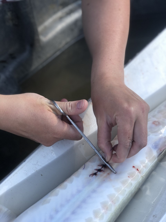
Biologists began searching for and tracking tagged adult pallid sturgeon in late-March and early April. Telemetry tracking in the Upper Missouri and Yellowstone Rivers is accomplished through a combination of traditional active tracking from watercraft and by a passive network of telemetry receivers located along the banks of the rivers (see previous blogs, Cellular Technology Monitors Sturgeon Across 300 Miles of Remote River and Remotely Monitoring Pallid Sturgeon Movement in Real Time). Aggregations of reproductive males typically form in late-May through late-June at spawning sites. Spawning can occur within hours of a reproductive female joining an aggregation of males. If spawning behavior is noted, biologists will deploy large, 150-foot trammel nets to recapture female sturgeon to verify that they have released their eggs and to detect the presence of males expressing milt. Female pallid sturgeon will typically lose 5–15% or more of their body weight when releasing eggs. A blood sample is taken to measure changes in hormones that occur with spawning. An ultrasound examination (see previous blog post, Mobile Ultrasound Technology Empowers Field Biologists) confirms that the female pallid sturgeon’s ovaries no longer contain eggs (figure 1).

Once spawning is believed complete and a post-spawn female pallid sturgeon has been recaptured and assessed (see previous blog post, A Spawning Recorded in the Yellowstone River), CSRP biologists will sample to collect eggs and drifting free embryos immediately downstream of the suspected spawning site (figure2). With water temperatures in the Yellowstone River approaching 22–23 degrees Celsius, sturgeon eggs will hatch approximately 3–4 days after fertilization. Genetic analyses of preserved eggs and free embryos collected below spawning sites are used to validate that pallid sturgeon spawned successfully and to identify the number and identity of the adults that spawned in the aggregation at that site (see previous blog post, New Foundation for Genetic Identification of Scaphirhynchus Sturgeon). Verifying and validating when, where, and in what conditions pallid sturgeon successfully spawn provides critical information needed to guide habitat restoration and flow management actions.
Remote Sensing Techniques to Quantify Dye Dispersal
By Brandon Sansom, PhD and Robert Jacobson, PhD
May 19, 2021
The Searcy’s Bend dye experiment was designed to collect data on dye transport and retention at multiple, complementary scales. In addition to data collected on fluorometers at specific points, the experiment included multiple aircraft and multiple sensing techniques to evaluate how dye was transported over scales of centimeters to thousands of meters.

Unmanned aerial systems (UAS’s) were flown by scientists from USGS and Missouri University of Science and Technology. Two UAS’s flew at 1200 ft above ground level (AGL) and collected standard color video (4 visible bands) of the dye movement through the Searcy Bend Interception-Rearing Complex, which was designed by the Corps of Engineers to intercept pallid sturgeon larvae to allow them to grow and survive in the Missouri River. A third UAS flew at 400 ft AGL and collected hyperspectral imagery. The hyperspectral imagery consists of several hundred spectral bands that provide much more information about transported constituents in the water compared to the visible bands.

Simultaneously, a fixed-wing aircraft flew at 5600 ft AGL and collected multi-spectral (three visible bands plus infrared) data by flying 20-minute continuous loops 8 times over the 7-mile study reach. The imagery from the fixed-wing aircraft is lower resolution compared to the UAS data but provides the comprehensive spatial view that includes all the complexity of this reach, including the main channel, slow areas behind wing dikes, shallow areas along sand bars, and secondary channels.

The River Runs Red
By Brandon Sansom, PhD and Robert Jacobson, PhD
May 17, 2021
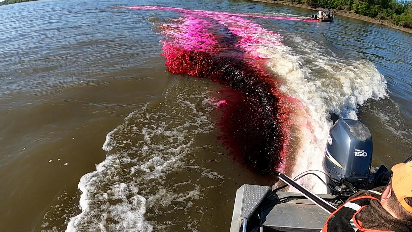
The execution of the dye-trace experiment required coordinated efforts between several boat operators, unmanned aerial systems (UAS) pilots, and a fixed-wing-aircraft pilot. The release of the dye occurred at 9:00 am on May 5 and required precise preparation and communication between the fixed-wing-aircraft pilot and the crew on the water responsible for releasing the dye into the river. In total, 16 CERC scientists and technicians were spread across seven boats assisting with the dye-release. Two boats were responsible for lining up along the channel center and simultaneously releasing the dye into the river as the boats drove towards opposite banks and as the aircraft made its first pass. A boat located about two miles downstream of the dye release location was equipped with a fluorometer, spectroscopy equipment, and an acoustic Doppler current profiler (ADCP) to monitor the concentration of the dye and characterize the depth and water velocity as the dye passed by. Two other boats were also equipped with ADCP’s and characterized the depth and water velocity at select transects throughout the entire reach while the remaining two boats assisted with deploying fluorometers throughout the study reach and documenting the study with video and photography.


In addition to the crew on the water, multiple aircraft were flying above the reach and documenting the movement of dye downstream. Four additional scientists from USGS and Missouri University of Science and Technology were flying UAS's to collect standard video and hyperspectral imagery as dye moved through the interception rearing complex (IRC) at Searcy’s Bend. Multispectral imagery of the entire 7-mile experimental reach was acquired by fixed-wing aircraft 8 times during the experiment in 20 minute passes.

Missouri River Dye Trace Experiment at Searcy’s Bend, Missouri
By Brandon Sansom, PhD and Robert Jacobson, PhD
May 6, 2021

CERC scientists conducted a dye-trace experiment on the Missouri River near Hunstdale, MO on May 5, 2021 in cooperation with scientists from the USGS Geomorphology and Sediment Transport Laboratory – Integrated Modeling and Prediction Division in Golden, CO, the USGS Geosciences and Environmental Change Science Center – National Unmanned Aircraft Systems Project Office in Denver, CO, Missouri University of Science and Technology, the U.S. Army Corps of Engineers, and Surdex Corporation St. Louis, MO. The scope and scale of the experiment was unprecedented on the Missouri River.
The study involved releasing approximately 23 gallons of Rhodamine-WT into the river about two miles downstream of the Interstate-70 bridge in Boone County, MO. Rhomamine-WT is a non-toxic but very visible dye that is frequently used to study time of travel in river systems. Scientists monitored the dispersal of dye downstream for five miles using a series of in-situ fluorometers installed throughout the river. In addition, a series of videos and photographs were captured using multiple aircraft.
The results of the dye experiment will help scientists better understand how age-0 pallid sturgeon disperse downstream and how they are able to find suitable habitat in the complex flow of the Missouri River. In particular, the data will be compared to computer simulations to evaluate how well the computer models predict transport of larvae into restoration projects — called interception-rearing complexes, or IRCs — designed to increase growth and survival of pallid sturgeon. The results will also be useful for predicting transport and fate of contaminants, for example after an oil spill. Moreover, comparing the results from in-situ sensor and remote sensing images may improve the ability to monitor dye dispersal using remote sensing technology in future dye-release experiments.

Minimally Invasive Implantation of Spawning-Event Tags in Sturgeon
April 22, 2021
By Aaron DeLonay and Kimberly Chojnacki
The USGS Comprehensive Sturgeon Research Project and its partners have identified and mapped spawning habitats in the Lower Yellowstone River and the Lower Missouri River by intensively monitoring the movement of telemetry tagged pallid sturgeon and recapturing them at suspected spawning sites (see “Characterization of Pallid Sturgeon (Scaphirhynchus albus) Spawning Habitat in the Lower Missouri River”). The primary telemetry transmitters used in pallid sturgeon are surgically implanted in the abdomen of adult fish. They allow biologists to track and record location and movement of pallid sturgeon through the lifespan of the transmitter (3–5 years). Unfortunately, biologists cannot follow large numbers of tagged sturgeon continuously over hundreds of miles of river, and critical behaviors, such as spawning, are not readily detected in the swift, turbid water. Biologists need a way to remotely monitor if a female sturgeon has spawned and to precisely determine where spawning has occurred.

In 2019–2020 CSRP biologists conducted laboratory trials with shovelnose sturgeon to evaluate the use of small, secondary transmitters to use as a spawning-event tags. Spawning event tags are designed to aid in identifying the timing and location of sturgeon ovulation and deposition of eggs. Spawning-event tags are short-term tags (30-120 days) inserted into the oviduct using a minimally invasive procedure through the urogenital vent. Theses tags are designed to be released by the female during ovulation and spawning in or near a spawning patch.

Before spawning occurs, the biologists tracking a tagged female will detect the signals from both the primary tag and secondary, spawning-event tag. At spawning, the signals from both tags will appear to separate from one another as the spawn-event tag is deposited on the substrate of the spawning patch with the eggs. Separation of the tag from the female informs biologists tracking the female of her status and suggests that recapture to assess spawning success is advised. Location of a separated spawning-event tag at the river bed provides more precise definition of areas selected by sturgeon for spawning to focus mapping and habitat-characterization efforts. More precise definition of spawning events aids biologists in building conceptual models of spawning behavior and understanding the biomechanics of egg deposition and embryo survival (see “Physical characteristics and simulated transport of pallid sturgeon and shovelnose sturgeon eggs”). Spawning-event tags will be implanted in pallid sturgeon In the Missouri And Yellowstone Rivers for the first time in 2021.
The Week the Missouri River Stood Still
By Carrie Elliott, Kimberly Chojnacki, and Aaron DeLonay
March 17, 2021
In February, the Missouri River basin endured a prolonged blast of frigid winter weather. High temperatures in Mid-Missouri remained below 32 °F for nearly two weeks, while locations farther upstream were even colder. The bitter arctic air caused floes of pancake ice to form on the Lower Missouri River by February 10th. Pancake ice resembles what it sounds like–rounded discs or pads of ice on the water surface moving downstream in the current. The pads of ice collide and grind against each other as they move in the current forming characteristic raised edges at their margins (Figure 1). Pancake ice is lacy and beautiful, and the continuous grumble of the ice as it scrapes and grinds along the riverbanks attracts people down to the river to admire the force of nature. Ice floes during severe winters are one of the few conditions that keep Missouri River researchers off the water. Our research vessels are no match for the unrelenting crush of ice.

After several consecutive days of temperatures far below freezing it was clear that conditions on the river were becoming more severe. On February 17, the U.S. Geological Survey streamflow gage near Jefferson City, Missouri suddenly dropped 4 feet (Figure 2). An ice jam was reported near river mile 145.5, just upstream from the Highways 63/54 Missouri River bridge at Jefferson City, Missouri.

The extreme cold caused the ice to pile up on the surface of the river forming an ice jam. The surface of the river became a jagged, white mass of ice. At its peak, the ice jam extended from Jefferson City to Waverly, Missouri–approximately 150 miles upstream. This was the first time since the 1980’s that the river froze over in mid-Missouri.

The polar air that held mid-Missouri in its grip finally relented. Several days of temperatures above freezing caused the ice to begin to melt. In the early morning hours of February 23, the river suddenly rose over 8 feet as the ice jam broke up and began to move downstream. For additional information, photographs, and drone footage of the ice jam visit The Missouri River Ice Jam of 2021 by Missouri River Relief.
Mobile Ultrasound Technology Empowers Field Biologists
By Sabrina Davenport, Patrick Braaten, and Casey Hickcox
March 8, 2021
Knowing the sex and reproductive status of pallid sturgeon is important for many monitoring and research activities, and ultrasound is a valuable tool to address these uncertainties. To enhance monitoring and research capabilities, the Comprehensive Sturgeon Research Project will be transferring new, low-cost mobile ultrasound technology from the laboratory to field biologists in 2021. Previously, ultrasound assessments had been administered by specially trained staff on a limited basis. These trained sonographers met field biologists on the river after they captured pallid sturgeon. Ultrasound assessments determined if fish were male or female, and helped identify fish that were candidates for surgical implantation of telemetry transmitter or valuable for transport to the hatchery as parental broodstock. When field biologists captured pallid sturgeon and a trained sonographer wasn’t available, the sturgeon would often be released without knowledge of sex or reproductive status. Oftentimes, rare pallid sturgeon that were not evaluated were transported from the river to a hatchery unnecessarily only to be returned when it was determined it was not reproductively mature. Even when a sonographer was available, pallid sturgeon had to wait several hours for evaluation while biologists worked to carefully maintain the sturgeon in tanks on the boat to minimize stress.

In 2021, field biologist throughout the Missouri and Yellowstone River basins will be trained on new, lower-cost and more-portable ultrasound platforms (continuing efforts from previous blog posts, The Cold Never Bothered Us Anyway and Training Sturgeon Surgeons). The new systems use portable ultrasound probes that connect to cell phones and tablets . Advances in technology and portability have reduced the costs of ultrasounds suitable for field use from nearly \$35,000 to as little as \$6,000. The new devices can be widely distributed and carried as standard equipment on watercraft sampling in remote areas for immediate assessment of sturgeon sex and reproductive readiness. Ultrasound imagery can be saved to the device’s memory for future reference or sent over a cellular internet connection to trained specialists in the laboratory for real-time expert consultation. Testing of the new ultrasound technologies was performed with hatchery brood stock in early 2021, and ultrasound imagery from the low-cost units was quite good in comparison to the higher-cost units (see figures).

Immediate knowledge of sex and reproductive readiness allows field biologists to make informed rapid decisions on how best to handle and treat the rare sturgeon and minimize stress while collecting as much information as possible. For example, if a fish is determined to be a female in reproductive condition based on ultrasound imagery, that fish will be a focus of intensive tracking to assess spawning migrations and identify spawning locations. This will allow biologists to better interpret observations of critical reproductive behaviors and focus additional resources on mapping and characterizing important spawning habitats.
New Foundation for Genetic Identification of Scaphirhynchus Sturgeon
By Kimberly Chojnacki, Richard Flamio, Jr., Dr. Edward Heist, and Aaron DeLonay
March 1, 2021
Researchers from the U.S. Geological Survey, Columbia Environmental Research Center and U.S. Geological Survey, Wetland and Aquatic Research Center recently published the results of a study conducted in collaboration with scientists at Southern Illinois University Carbondale. The scientific journal article, “Production of haploid gynogens to inform genomic resource development in the paleotetraploid pallid sturgeon (Scaphirhynchus albus)”, authored by Richard Flamio Jr. and others was published in the journal Aquaculture. The principal study investigators are from Dr. Edward Heist's laboratory at the Center for Fisheries Aquaculture and Aquatic Sciences at Southern Illinois University Carbondale. Hybridization with the closely related and more common shovelnose sturgeon is one of several threats to the endangered pallid sturgeon. Current molecular markers cannot reliably distinguish among the two pure Scaphirhynchus species and multigenerational backcrosses (hybrids). Identification of pure pallid sturgeon for use as broodstock in conservation propagation and augmentation efforts is critical to avoid jeopardizing species integrity while preserving genetic diversity and conserving local adaptation. Genotypes from a larger panel of unlinked single-nucleotide polymorphisms (SNPs) can provide greater resolution between the two species and hybrids. Development of the SNPs is complicated, however, by the evolutionary history of the sturgeon that has resulted in a whole genome duplication event (a doubling of the number of paired chromosomes of these two sturgeon species compared to other species). In this multi-year study, methods were developed to successfully produce pallid sturgeon offspring with DNA contributed only by the female parent; these offspring are called haploids. The simplified genome of the haploids can be more easily studied. Scientists used a technique called flow-cytometry to confirm that the haploid specimens produced in the study had only half the number of chromosomes of normal pallid sturgeon. Genetic analyses using 19 sturgeon microsatellite loci and four paddlefish loci confirmed that haploid specimens were 100% homozygous. The results of this study are a critical step necessary to inform future development of thousands of new, cost-effective genetic markers for Scaphirhynchus sturgeon.

This study is part of the Comprehensive Sturgeon Research Project (CSRP) funded by the U.S. Army Corps of Engineers, Missouri River Recovery–Integrated Science Program and the U.S. Geological Survey, Ecosystems Mission Area. Collaboration with Southern Illinois University Carbondale, Center for Fisheries, Aquaculture, and Aquatic Sciences was funded by CSRP through the Cooperative Ecosystem Studies Unit network grant program within the U.S. Geological Survey.
Citation: Flamio, R., Chojnacki, K.A., DeLonay, A.J., Dodson, M.J., Gocker, R.M., Jenkins, J.A., Powell, J., and Heist, E.J., 2021. Production of haploid gynogens in order to inform genomic resource development in the paleotetraploid pallid sturgeon (Scaphirhynchus albus). Journal of Aquaculture. https://doi.org/10.1016/j.aquaculture.2021.736529
To revisit what happened in 2020 at the Comprehensive Sturgeon Research project, click here!
To return to the Comprehensive Sturgeon Research Project Overview, click here!
To return to River Studies, click here!