
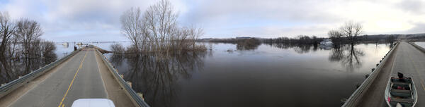
On April 10, USGS hydrographer Josh Sundberg measures Red River water flowing over the road in East Grand Forks, Minnesota as flood protection walls prevent further flooding.
Images
Dakota Water Science Center images.
Filter Total Items: 490

USGS Responds to Spring Flooding in Minnesota
On April 10, USGS hydrographer Josh Sundberg measures Red River water flowing over the road in East Grand Forks, Minnesota as flood protection walls prevent further flooding.

USGS Responds to Spring Flooding in North Dakota
On April 6, USGS hydrographer Spencer Wheeling carries equipment out to measure high water on the Tongue River near Akra, North Dakota.
On April 6, USGS hydrographer Spencer Wheeling carries equipment out to measure high water on the Tongue River near Akra, North Dakota.

USGS Responds to Spring Flooding in North Dakota
USGS hydrographer Chris Broz gets on the cold ground to measure the high-water mark of the Pembina River at Neche, North Dakota.
USGS hydrographer Chris Broz gets on the cold ground to measure the high-water mark of the Pembina River at Neche, North Dakota.

USGS Responds to Spring Flooding in North Dakota
USGS hydrographer Spencer Wheeling gets equipment ready to collect a flood water-quality sample on the Wild Rice River near St.
USGS hydrographer Spencer Wheeling gets equipment ready to collect a flood water-quality sample on the Wild Rice River near St.

USGS Responds to Spring Flooding in North Dakota
USGS hydrographer Brent Hanson wades out in freezing waters to collect flood measurements on the Sheyenne River near Cooperstown, North Dakota. Hanson reads an outside staff, which is a vertical graduated ruler used to calibrate the continuous readings of water level provided by electronic sensors.
USGS hydrographer Brent Hanson wades out in freezing waters to collect flood measurements on the Sheyenne River near Cooperstown, North Dakota. Hanson reads an outside staff, which is a vertical graduated ruler used to calibrate the continuous readings of water level provided by electronic sensors.

USGS Responds to Spring Flooding in North Dakota
A frozen USGS rapid deployment streamgage measures the height of the Maple River near Page, North Dakota. RDGs can be installed on short notice to provide additional information at locations that are normally not gauged.
A frozen USGS rapid deployment streamgage measures the height of the Maple River near Page, North Dakota. RDGs can be installed on short notice to provide additional information at locations that are normally not gauged.

Measuring high flows in Fargo, ND
An instrument called an acoustic Doppler current profiler (ADCP) takes streamflow measurements during flooding. The ADCP is attached to a buoy that is dragged in the water either alongside a boat or by hand. USGS hydrologist Dan Thomas points to the ADCP sensor on the Red River of the North during flooding in downtown Fargo, ND.
An instrument called an acoustic Doppler current profiler (ADCP) takes streamflow measurements during flooding. The ADCP is attached to a buoy that is dragged in the water either alongside a boat or by hand. USGS hydrologist Dan Thomas points to the ADCP sensor on the Red River of the North during flooding in downtown Fargo, ND.

Measuring floodwater in Fargo, ND
A USGS crew measures flooding on the Red River in downtown Fargo, North Dakota. The orange instrument is an acoustic Doppler current profiler, which is used to measure streamflow as it's pulled across the water.
A USGS crew measures flooding on the Red River in downtown Fargo, North Dakota. The orange instrument is an acoustic Doppler current profiler, which is used to measure streamflow as it's pulled across the water.

Measuring flooding in downtown Fargo, ND
USGS hydrologist Dan Thomas prepares to measure record flows on the Red River of the North in downtown Fargo, North Dakota. The orange instrument is an acoustic Doppler current profiler, which is used to measure streamflow as it's pulled across the water.
USGS hydrologist Dan Thomas prepares to measure record flows on the Red River of the North in downtown Fargo, North Dakota. The orange instrument is an acoustic Doppler current profiler, which is used to measure streamflow as it's pulled across the water.

Measuring high flows, Maple River, ND
A USGS crew measures high flow during flooding on the Maple River near Mapleton, North Dakota. The instrument being pulled across the water is an acoustic Doppler current profiler, which is used to measure streamflow. The truck is parked on a road that had been overtaken by the river.
A USGS crew measures high flow during flooding on the Maple River near Mapleton, North Dakota. The instrument being pulled across the water is an acoustic Doppler current profiler, which is used to measure streamflow. The truck is parked on a road that had been overtaken by the river.

Taking streamflow measurements during flooding in ND
Taking streamflow measurements during flooding in NDA USGS crew prepares to measure streamflow during record flooding on the Maple River near Mapleton, ND, on April 6, 2019. The instrument pictured is an acoustic Doppler current profiler which measures streamflow as it's dragged across the water.

Taking streamflow measurements in ND
A USGS crew measures streamflow during record flooding on the Red River of the North near Georgetown, ND, on April 6, 2019. The apparatus in the middle of the image is a USGS temporary streamgage installed to monitor flooding, and the orange instrument pictured is an acoustic Doppler current profiler that measures streamflow.
A USGS crew measures streamflow during record flooding on the Red River of the North near Georgetown, ND, on April 6, 2019. The apparatus in the middle of the image is a USGS temporary streamgage installed to monitor flooding, and the orange instrument pictured is an acoustic Doppler current profiler that measures streamflow.

Measuring flooding on the Maple River, ND
A USGS crew measures high flow during flooding on the Maple River near Mapleton, North Dakota. The yellow instrument is an acoustic Doppler current profiler, which is used to measure streamflow as it's pulled across the water. The crew is standing on a road that had been overtaken by the river.
A USGS crew measures high flow during flooding on the Maple River near Mapleton, North Dakota. The yellow instrument is an acoustic Doppler current profiler, which is used to measure streamflow as it's pulled across the water. The crew is standing on a road that had been overtaken by the river.

Measuring high water flow on the Maple River, ND
This is not a lake! A USGS crew measures high flow during flooding on the Maple River near Mapleton, North Dakota. The instrument being pulled across the water is an acoustic Doppler current profiler (ADCP), which is used to measure streamflow.
This is not a lake! A USGS crew measures high flow during flooding on the Maple River near Mapleton, North Dakota. The instrument being pulled across the water is an acoustic Doppler current profiler (ADCP), which is used to measure streamflow.

USGS crews respond to flooding on the Big Sioux River
USGS crews respond to flooding on the Big Sioux RiverUSGS scientists and technicians took water measurements during flooding on the Big Sioux River near Hawarden, Iowa in March 2019.
USGS crews respond to flooding on the Big Sioux River
USGS crews respond to flooding on the Big Sioux RiverUSGS scientists and technicians took water measurements during flooding on the Big Sioux River near Hawarden, Iowa in March 2019.

USGS crews respond to flooding on the Big Sioux River
USGS crews respond to flooding on the Big Sioux RiverUSGS technician Chris Broz helps take water measurements on the Big Sioux River during record flooding in March, 2019.
USGS crews respond to flooding on the Big Sioux River
USGS crews respond to flooding on the Big Sioux RiverUSGS technician Chris Broz helps take water measurements on the Big Sioux River during record flooding in March, 2019.
USGS takes water measurements during Big Sioux flooding
USGS takes water measurements during Big Sioux floodingUSGS scientists and technicians took water measurements during flooding on the Big Sioux River near Jefferson, SD in March 2019. Measurements for this site were 52,000 cfs at a gage height of 40.14 ft.

USGS crews respond to flooding on the Big Sioux River
USGS crews respond to flooding on the Big Sioux RiverUSGS technician Chris Broz helps take water measurements on the Big Sioux River during record flooding in March, 2019.
USGS crews respond to flooding on the Big Sioux River
USGS crews respond to flooding on the Big Sioux RiverUSGS technician Chris Broz helps take water measurements on the Big Sioux River during record flooding in March, 2019.

USGS crews respond to flooding on the Big Sioux River
USGS crews respond to flooding on the Big Sioux RiverUSGS technician Chris Broz helps take water measurements on the Big Sioux River during record flooding in March, 2019.
USGS crews respond to flooding on the Big Sioux River
USGS crews respond to flooding on the Big Sioux RiverUSGS technician Chris Broz helps take water measurements on the Big Sioux River during record flooding in March, 2019.

USGS crews respond to flooding on the Big Sioux River
USGS crews respond to flooding on the Big Sioux RiverUSGS scientists and technicians took water measurements during flooding on the Big Sioux River near Hawarden, Iowa in March 2019.
USGS crews respond to flooding on the Big Sioux River
USGS crews respond to flooding on the Big Sioux RiverUSGS scientists and technicians took water measurements during flooding on the Big Sioux River near Hawarden, Iowa in March 2019.
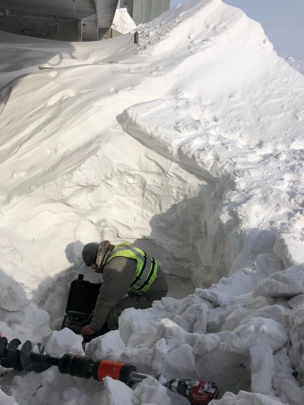
Winter Streamflow Measurement at the Rush River at Amenia, ND
Winter Streamflow Measurement at the Rush River at Amenia, NDUSGS Hydrologic Technician Chris Broz attempting to find flow at the Rush River at Amenia, ND (USGS streamgage 05060500). It took the technicians an hour to dig through the snow drift under the wire weight gage just to get to the ice. Then they drilled holes in the ice so they could see if there was any water to measure.