
Cheatgrass Dieoff Time-series Dynamics (2000 – 2010)
Cheatgrass (Bromus tectorum L.) is a winter annual grass that has invaded and altered the shrub steppe ecosystem in the Great Basin for about 100 years. This highly competitive grass invades recently disturbed areas and then outcompetes most native vegetation by using requisite resources like soil water and nutrients in early spring before other native plants. It also can alter its phenotype and invade new areas with different site characteristics. After cheatgrass invades, it provides a fine fuel that easily burns, thereby increasing the number and area of fire disturbances that, in return, create more opportunities for cheatgrass to invade. This positive feedback loop is perhaps the most troublesome aspect of cheatgrass' invasion in the Great Basin. Because of cheatgrass' competitive advantages, including its exploitation of fire, cheatgrass is the dominant land cover over about 20,000 km 2 of the Great Basin (Bradley and Mustard 2005).
However, since the early 2000s in northern Nevada, and perhaps longer in other areas of the Great Basin, a phenomenon has been observed by land managers where cheatgrass stands fail to establish in previously invaded areas during years with adequate precipitation. This cheatgrass dieoff is a concern to land managers, scientists, and policy makers. Even though cheatgrass dieoff may be viewed as a windfall, it is problematic because areas experiencing cheatgrass dieoff can be susceptible to accelerated soil erosion, invasion of new weed species, and loss of early spring forage. Restoration efforts can be attempted in dieoff areas, but until the cause(s) of dieoffs can be determined, it may be unwise to spend limited resources to attempt restoration.
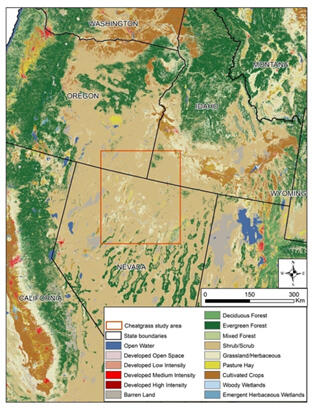
Cheatgrass cover in the Great Basin is highly variable, both spatially and temporally, because as an annual grass, cheatgrass is highly sensitive to weather patterns, particularly precipitation. Developing a time series of cheatgrass dynamic datasets and maps would be extremely valuable to Great Basin stakeholders because it would allow them to monitor cheatgrass from year to year and to analyze general trends. But, comparing one year's cheatgrass cover to another year's without considering inter-annual weather variation can confound analysis and result in data misinterpretation. We employed the power of rule-based piecewise regression-tree models to integrate remote sensing data with topographic, edaphic, land cover, and weather data to enhance the understanding of annual cheatgrass dynamics within the context of cheatgrass dieoff. The residuals of our cheatgrass performance models normalized production anomalies for annual weather and produced maps that permitted analyses that extended beyond tracking cheatgrass cover patterns. It added valuable context to the analyses by allowing us to separate cheatgrass cover changes caused by disturbances or management activities from those that result from annual weather patterns. We then could identify areas of possible cheatgrass dieoff with more confidence and predict dieoff probability. We developed cheatgrass cover and dieoff estimates for a portion of the Great Basin in northern Nevada, southeastern Oregon, and southwestern Idaho (Fig. 1). However, we only displayed the cheatgrass dieoff estimates in this presentation.
Reports
References
Bradley BA, Mustard JF (2005) Identifying land cover variability distinct from land cover change: Cheatgrass in the Great Basin. Remote Sensing of Environment 94(2):204-213
Below are other science projects associated with this project.

Near-Real-Time Cheatgrass Monitoring

Ecosystem Performance, Productivity and Sustainability
Cheatgrass (Bromus tectorum L.) is a winter annual grass that has invaded and altered the shrub steppe ecosystem in the Great Basin for about 100 years. This highly competitive grass invades recently disturbed areas and then outcompetes most native vegetation by using requisite resources like soil water and nutrients in early spring before other native plants. It also can alter its phenotype and invade new areas with different site characteristics. After cheatgrass invades, it provides a fine fuel that easily burns, thereby increasing the number and area of fire disturbances that, in return, create more opportunities for cheatgrass to invade. This positive feedback loop is perhaps the most troublesome aspect of cheatgrass' invasion in the Great Basin. Because of cheatgrass' competitive advantages, including its exploitation of fire, cheatgrass is the dominant land cover over about 20,000 km 2 of the Great Basin (Bradley and Mustard 2005).
However, since the early 2000s in northern Nevada, and perhaps longer in other areas of the Great Basin, a phenomenon has been observed by land managers where cheatgrass stands fail to establish in previously invaded areas during years with adequate precipitation. This cheatgrass dieoff is a concern to land managers, scientists, and policy makers. Even though cheatgrass dieoff may be viewed as a windfall, it is problematic because areas experiencing cheatgrass dieoff can be susceptible to accelerated soil erosion, invasion of new weed species, and loss of early spring forage. Restoration efforts can be attempted in dieoff areas, but until the cause(s) of dieoffs can be determined, it may be unwise to spend limited resources to attempt restoration.
Cheatgrass cover in the Great Basin is highly variable, both spatially and temporally, because as an annual grass, cheatgrass is highly sensitive to weather patterns, particularly precipitation. Developing a time series of cheatgrass dynamic datasets and maps would be extremely valuable to Great Basin stakeholders because it would allow them to monitor cheatgrass from year to year and to analyze general trends. But, comparing one year's cheatgrass cover to another year's without considering inter-annual weather variation can confound analysis and result in data misinterpretation. We employed the power of rule-based piecewise regression-tree models to integrate remote sensing data with topographic, edaphic, land cover, and weather data to enhance the understanding of annual cheatgrass dynamics within the context of cheatgrass dieoff. The residuals of our cheatgrass performance models normalized production anomalies for annual weather and produced maps that permitted analyses that extended beyond tracking cheatgrass cover patterns. It added valuable context to the analyses by allowing us to separate cheatgrass cover changes caused by disturbances or management activities from those that result from annual weather patterns. We then could identify areas of possible cheatgrass dieoff with more confidence and predict dieoff probability. We developed cheatgrass cover and dieoff estimates for a portion of the Great Basin in northern Nevada, southeastern Oregon, and southwestern Idaho (Fig. 1). However, we only displayed the cheatgrass dieoff estimates in this presentation.
Reports
References
Bradley BA, Mustard JF (2005) Identifying land cover variability distinct from land cover change: Cheatgrass in the Great Basin. Remote Sensing of Environment 94(2):204-213
Below are other science projects associated with this project.
Near-Real-Time Cheatgrass Monitoring