
Images
Images captured by GLSC scientists while working in and around the Great Lakes.
Filter Total Items: 494
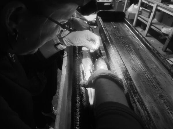
Tagging Round Whitefish
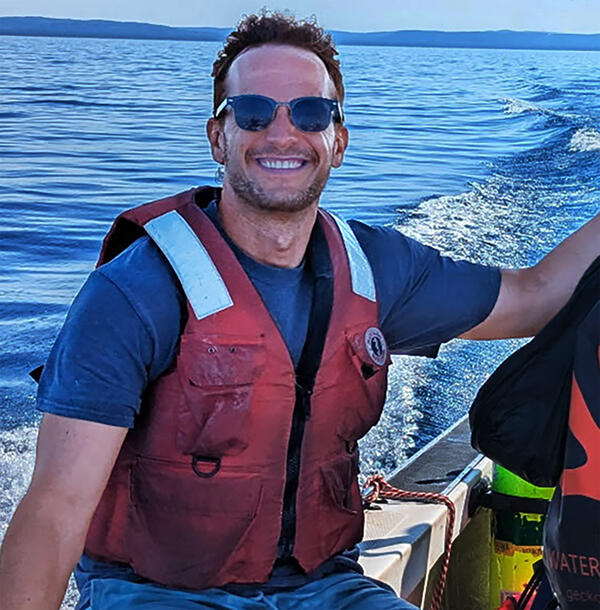
Benjamin Kramer on Lake Michigan in 2025
Dr. Benjamin Kramer is shown on a small research vessel in July 2025 near Sleeping Bear Dunes in Leelanau County, MI collecting benthic mats on Good Harbor Reef as part of USGS's UMESC SWIM (Spawning Whitefish Invasive Mussels) project. Photo Credi: Megan Lewan, USGS
Dr. Benjamin Kramer is shown on a small research vessel in July 2025 near Sleeping Bear Dunes in Leelanau County, MI collecting benthic mats on Good Harbor Reef as part of USGS's UMESC SWIM (Spawning Whitefish Invasive Mussels) project. Photo Credi: Megan Lewan, USGS
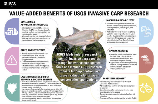
Value-added Benefits of USGS Invasive Carp Research
Value-added Benefits of USGS Invasive Carp ResearchThe USGS leads federal research to control invasive carp species through innovative management tools and methods. Our research products for carp control have proven valuable for broader conservation applications.
DEVELOPING & ADVANCING TECHNOLOGIES
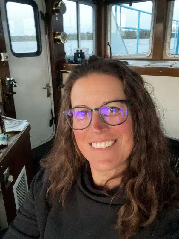
Nicole Watson
Profile image of Fisheries Biologist Nicole Watson beginning her watch onboard the R/V Kiyi in Quebec Harbor, Lake Superior.
Profile image of Fisheries Biologist Nicole Watson beginning her watch onboard the R/V Kiyi in Quebec Harbor, Lake Superior.

How Fish Hear
Olivia Mitchinson demonstrates alewife otolith removal to participants of angler workshop held at the State University of New York in Oswego. Otoliths are the structures that allow a fish to hear by picking up vibrations in the water. Photo credit: Jacob Bulich, USGS.
Olivia Mitchinson demonstrates alewife otolith removal to participants of angler workshop held at the State University of New York in Oswego. Otoliths are the structures that allow a fish to hear by picking up vibrations in the water. Photo credit: Jacob Bulich, USGS.

Three-Dimensional Data Visualization
Three-dimensional reconstruction of a short section of lakebed imagery into a color point cloud (top) and orthomosaic (bottom), with a zoomed in view (right). These georeferenced data products are typical to many mobile platforms. Photo credit: Phil Wernette, USGS.
Three-dimensional reconstruction of a short section of lakebed imagery into a color point cloud (top) and orthomosaic (bottom), with a zoomed in view (right). These georeferenced data products are typical to many mobile platforms. Photo credit: Phil Wernette, USGS.
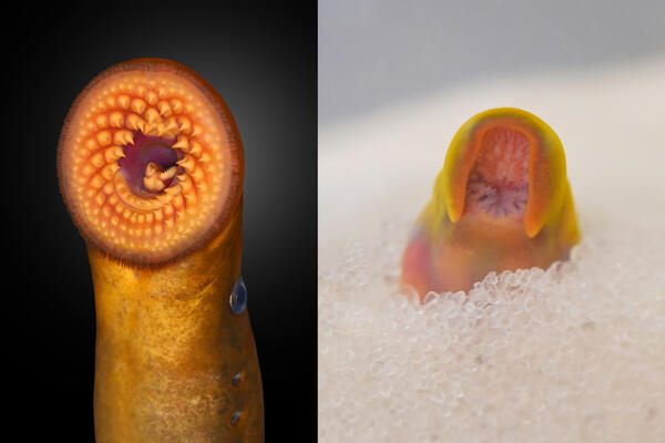
Double Take
The mouth of an adult invasive sea lamprey (Petromyzon marinus) captured from the Great Lakes (left) and the developing parasitic mouth of a juvenile invasive sea lamprey growing in experimental substrate (right) at the USGS Hammond Bay Biological Station (GLSC; Millersburg, Michigan). Photo credit: Andrea Miehls, USGS-GLSC.
The mouth of an adult invasive sea lamprey (Petromyzon marinus) captured from the Great Lakes (left) and the developing parasitic mouth of a juvenile invasive sea lamprey growing in experimental substrate (right) at the USGS Hammond Bay Biological Station (GLSC; Millersburg, Michigan). Photo credit: Andrea Miehls, USGS-GLSC.

Sampling in the Oswego Harbor
A USGS research crew (GLSC; Oswego, New York) sampling environmental DNA (eDNA) aboard the R/V Niagara in Oswego Harbor, New York. The eDNA will inform cisco spawning dynamics in bays along Lake Ontario and is associated with the Great Lakes Restoration Initiative’s coregonine spawning habitat projects.
A USGS research crew (GLSC; Oswego, New York) sampling environmental DNA (eDNA) aboard the R/V Niagara in Oswego Harbor, New York. The eDNA will inform cisco spawning dynamics in bays along Lake Ontario and is associated with the Great Lakes Restoration Initiative’s coregonine spawning habitat projects.
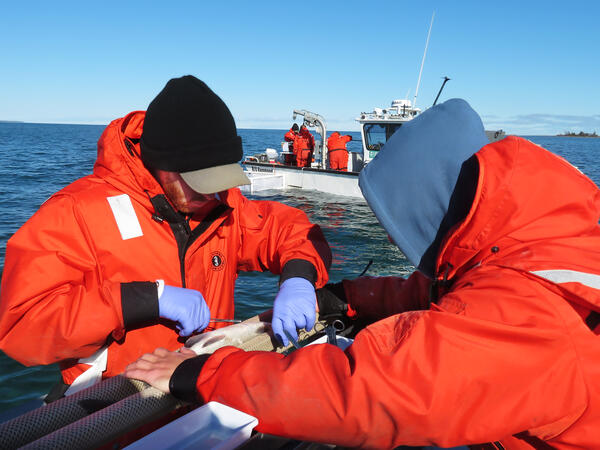
Tagging Lake Whitefish in Thunder Bay
USGS researchers (GLSC; Millersburg, Michigan) tag a lake whitefish (Coregonus clupeaformis) with an acoustic transmitter as part of a multi-agency project looking at lake whitefish habitat use and movement patterns in Lake Huron. Photo credit: Brad Buechel, USGS-GLSC.
USGS researchers (GLSC; Millersburg, Michigan) tag a lake whitefish (Coregonus clupeaformis) with an acoustic transmitter as part of a multi-agency project looking at lake whitefish habitat use and movement patterns in Lake Huron. Photo credit: Brad Buechel, USGS-GLSC.
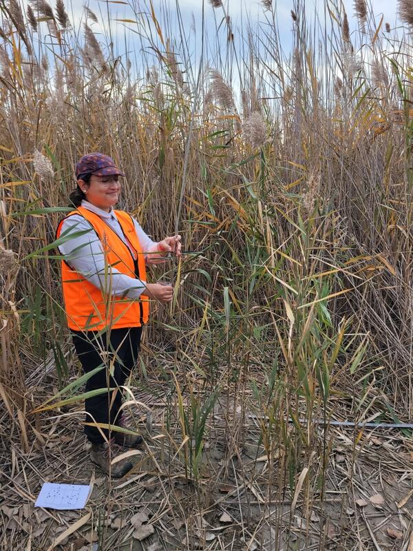
Measuring the Effect
A USGS intern surveys non-native Phragmites australis at a research site in Milan, Michigan, following an experimental non-toxic bioherbicide treatment in 2024. Photo credit: USGS.
A USGS intern surveys non-native Phragmites australis at a research site in Milan, Michigan, following an experimental non-toxic bioherbicide treatment in 2024. Photo credit: USGS.

Fish Suture
A researcher closing an incision after surgical implantation of an acoustic transmitter in a lake whitefish, October 2024. Photo credit: Brad Buechel, USGS.
A researcher closing an incision after surgical implantation of an acoustic transmitter in a lake whitefish, October 2024. Photo credit: Brad Buechel, USGS.
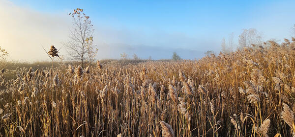
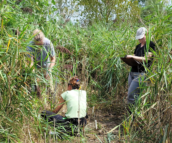
A Sea of Phragmites
Invasive Phragmites australis in the early morning sunshine at Crystal Waters State Game Area in Michigan, taken before a day of field sampling by USGS scientists (GLSC; Ann Arbor, Michigan). Photo credit: McKenzie Smith, USGS - GLSC.
Invasive Phragmites australis in the early morning sunshine at Crystal Waters State Game Area in Michigan, taken before a day of field sampling by USGS scientists (GLSC; Ann Arbor, Michigan). Photo credit: McKenzie Smith, USGS - GLSC.

A Lone Net Float
Gill net float at entrance to backwater habitat set to capture Grass Carp in the lower Huron River, OH. Photo credit: James Roberts, USGS.
Gill net float at entrance to backwater habitat set to capture Grass Carp in the lower Huron River, OH. Photo credit: James Roberts, USGS.
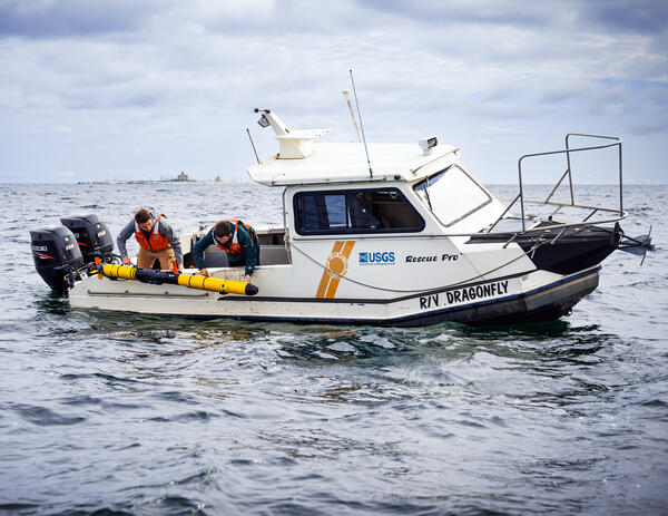
AUV Deployment
A USGS technician and contractor (GLSC; Ann Arbor, Michigan) deploy an Iver3 Autonomous Underwater Vehicle (AUV) from the Research Vessel Dragonfly in Lake Michigan's Porte des Morts in Door County, Wisconsin. Data collected from the AUV are being used to characterize and map physical habitats and invasive species on the lakebed as
A USGS technician and contractor (GLSC; Ann Arbor, Michigan) deploy an Iver3 Autonomous Underwater Vehicle (AUV) from the Research Vessel Dragonfly in Lake Michigan's Porte des Morts in Door County, Wisconsin. Data collected from the AUV are being used to characterize and map physical habitats and invasive species on the lakebed as
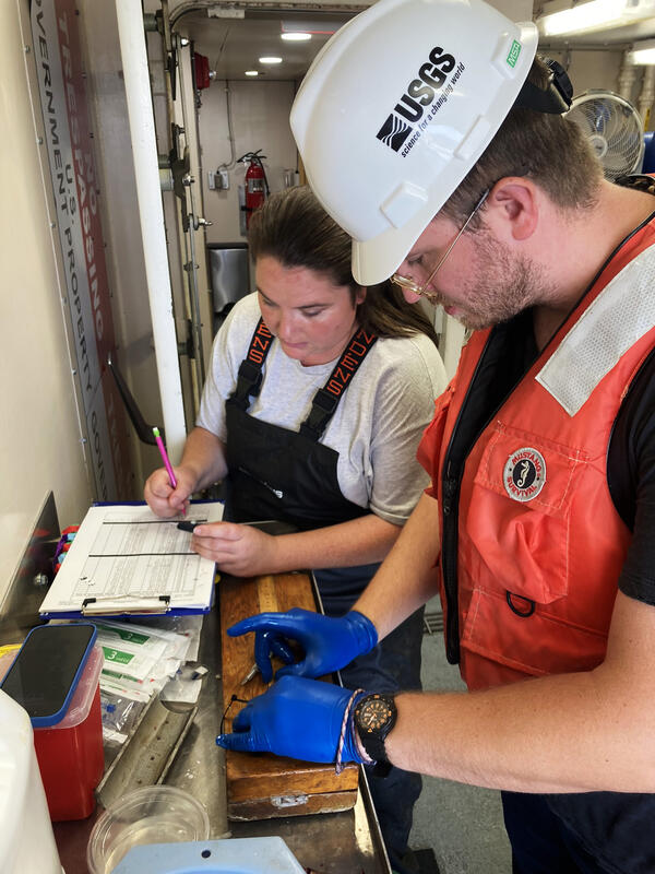
Fish Glucose Analysis Aboard the Research Vessel Arcticus
Fish Glucose Analysis Aboard the Research Vessel ArcticusUSGS researchers (GLSC; Cortland, New York; Ann Arbor, Michigan) collecting and recording fish glucose levels from specimens caught during a Lake Michigan bottom trawl survey aboard the R/V Arcticus. Data were used to test alternative processing methods to inform future Gre
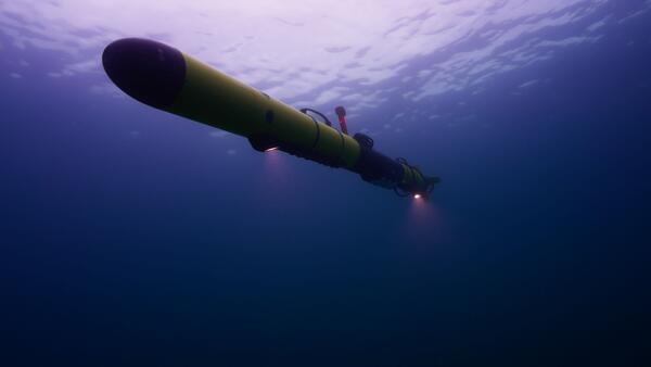
AUV in Action
An autonomous underwater vehicle taking images underwater in Lake Michigan as part of the USGS Great Lakes Science Center Computer Vision project (Ann Arbor, Michigan). Photo credit: Zach Melnick, Inspired Planet Ideas Inc.; used with permission.
An autonomous underwater vehicle taking images underwater in Lake Michigan as part of the USGS Great Lakes Science Center Computer Vision project (Ann Arbor, Michigan). Photo credit: Zach Melnick, Inspired Planet Ideas Inc.; used with permission.
Phragmites Monitoring
USGS scientists (GLSC; Ann Arbor, Michigan) assess the health of invasive Phragmites australis that was treated with a naturally derived herbicide. Photo credit: Spenser Widin, USGS-GLSC.
USGS scientists (GLSC; Ann Arbor, Michigan) assess the health of invasive Phragmites australis that was treated with a naturally derived herbicide. Photo credit: Spenser Widin, USGS-GLSC.
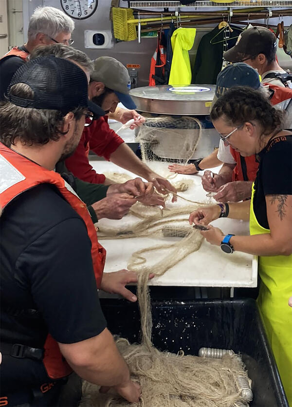
Group Effort Sorting Fish Aboard the Research Vessel Kiyi
Group Effort Sorting Fish Aboard the Research Vessel KiyiAll hands on deck as USGS researchers (GLSC; Ashland, Wisconsin; Ann Arbor, Michigan) sort out native coregonine species caught as part of the Deepwater Cisco survey on Lake Superior aboard the R/V Kiyi. Photo credit: Patty Dieter, USGS-GLSC.
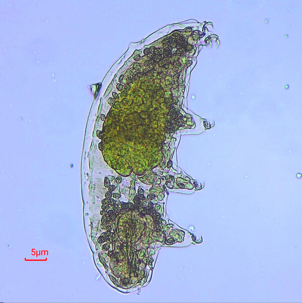
Hidden Sampling Find
A tardigrade observed under the microscope by a USGS researcher (GLSC; Chesterton, Indiana) while processing algae samples from Lake Huron as part of an on-going Cladophora assessment project. Photo credit: Jessica Oswald, USGS-GLSC.
A tardigrade observed under the microscope by a USGS researcher (GLSC; Chesterton, Indiana) while processing algae samples from Lake Huron as part of an on-going Cladophora assessment project. Photo credit: Jessica Oswald, USGS-GLSC.
When the Wind Blows…Open the Net
USGS researchers on the St. Clair Detroit River System (SCDRS) crew (GLSC; Ann Arbor, Michigan) beginning the annual seine survey at Pointe Mouillee State Game Area's Banana Dike, near the mouth of the Detroit River. The wind offered a helping hand—expanding the net for the team (albeit in the wrong direction!). Photo credit: Stacy Provo, USGS-GLSC.
USGS researchers on the St. Clair Detroit River System (SCDRS) crew (GLSC; Ann Arbor, Michigan) beginning the annual seine survey at Pointe Mouillee State Game Area's Banana Dike, near the mouth of the Detroit River. The wind offered a helping hand—expanding the net for the team (albeit in the wrong direction!). Photo credit: Stacy Provo, USGS-GLSC.
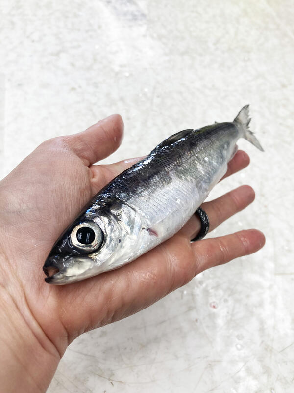
What Big Eyes You Have
A Kiyi (Coregonus kiyi), captured from a gillnet during field sampling aboard the USGS Research Vessel Kiyi (GLSC; Ashland, Wisconsin), near the Apostle Islands in Lake Superior. Read more about Great Lakes coregonine species, their dramatic decline, and the work being done to protect them, here.
A Kiyi (Coregonus kiyi), captured from a gillnet during field sampling aboard the USGS Research Vessel Kiyi (GLSC; Ashland, Wisconsin), near the Apostle Islands in Lake Superior. Read more about Great Lakes coregonine species, their dramatic decline, and the work being done to protect them, here.