
Next Generation Water Observing System (NGWOS) - Advancing Soil Moisture Monitoring
Soil moisture is an important part of the climate system, but it remains difficult to measure accurately. In 2022, the U.S. Geological Survey (USGS) began building a soil moisture monitoring network to provide high-quality continuous soil moisture data, standardize data collection methods, and test new technologies. Stations are placed in different climates and land cover types to capture a broad range of conditions.
Soil Moisture Monitoring Research
Soil moisture—also called soil water content (SWC)—plays a key role in the water cycle. However, it is hard to measure SWC in a way that accurately represents a whole landscape. Traditional in-ground sensors measure only a very small area and are sensitive to local conditions. Many hydrologic studies need estimates that represent much larger areas that can be applied to entire watersheds.
To improve large‑area SWC measurement, the USGS - Next Generation Water Observing System (NGWOS) is testing both traditional in‑ground sensors and newer technologies, including cosmic‑ray neutron sensors (CRNS). CRNS can measure SWC over areas hundreds of meters wide and to a depth of about 20–30 cm, helping bridge the gap between small point measurements and watershed‑scale models.
How CRNS Measures Soil Moisture
- Cosmic rays strike Earth’s atmosphere and generate particles, including neutrons
- Neutrons slow down when they interact with water in the soil
- The above ground sensor counts “fast” (epithermal) and “slow” (thermal) neutrons
- Fewer fast neutrons = wetter soil
A short summary of how CRNS technology works is available in the CRNS overview video.
Field Testing
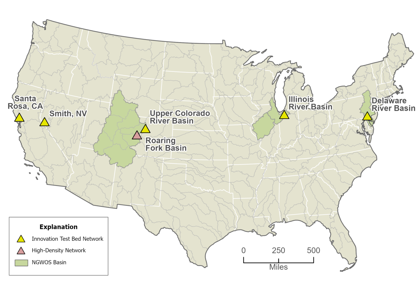
USGS is testing CRNS at five Innovation Test Bed (ITB) stations across the continental United States. These stations represent different land cover types, climates, geology, and hydrologic conditions. Three stations are located within NGWOS Integrated Water Science (IWS) basins and are co-located with existing USGS research stations.
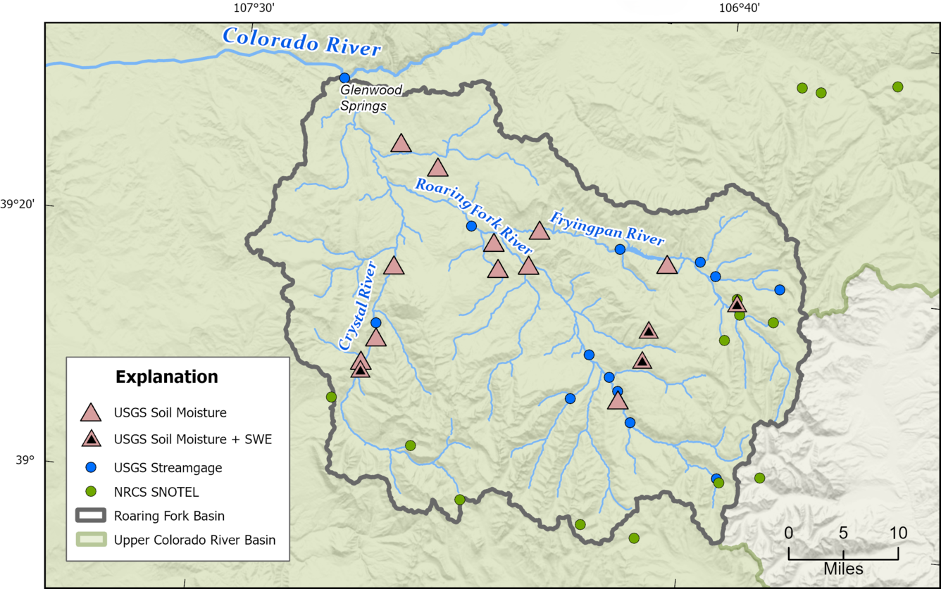
In 2023, USGS installed a dense network of 15 CRNS in the Roaring Fork Basin, Colorado. This network helps evaluate how well CRNS supports watershed‑scale water‑balance estimates (Figure 2). The Roaring Fork Basin already has a dense network of USGS streamgages, making a water-balance study possible. CRNS can also measure snow water equivalent (SWE). Four high-elevation CRNS stations in this network also include CRNS dedicated to continuous SWE measurements.
Each CRNS station measures epithermal and thermal neutron counts above land surface, along with air temperature, relative humidity, barometric pressure, and precipitation. Soil moisture and temperature are also measured with in-ground sensors at multiple depths to validate CRNS data. ITB stations also have multiple sub stations within the CRNS measurement footprint.
Van Horn CRNS soil moisture monitoring station
DE 723 CRNS soil moisture monitoring station
Hanna CRNS soil moisture monitoring station
| Station ID and Data link | Station Name | State | Network | Land Cover Description |
|---|---|---|---|---|
| 383512122420801 | 009N008W36 CRNS SOIL | CA | Innovation Test Bed | Scrub oak |
| 384840119175701 | SMITH VALLEY NTN SITE NR SMITH, NV | NV | Innovation Test Bed | Sagebrush |
| 395448105453601 | RANCH CR MEADOW METEOROLOGICAL STA NR FRASER CO | CO | Innovation Test Bed | Alpine meadow |
| 395512075293701 | DE 723 Delaware County Observation Well | PA | Innovation Test Bed | Deciduous forest |
| 412349086423701 | CRNS Atmospheric Station near Hanna IN | IN | Innovation Test Bed | Corn/soybean field |
| 391014106480001 | NORTH STAR METEOROLOGICAL STATION NEAR ASPEN, CO | CO | Roaring Fork Basin | Wetland/aspen |
| 391020107144201 | REDSTONE CASTLE MET STATION AT REDSTONE, CO | CO | Roaring Fork Basin | Ponderosa pine |
| 391059107144601 | COKE OVENS METEOROLOGICAL STATION AT REDSTONE, CO | CO | Roaring Fork Basin | Hay/pasture |
| 391257107133001 | CRYSTAL RIVER MET STA AT DORIAS WAY NR REDSTONE CO | CO | Roaring Fork Basin | Cottonwood riparian |
| 391336106455801 | VAN HORN PARK MET STATION NEAR ASPEN, CO | CO | Roaring Fork Basin | Alpine meadow |
| 391600106453901 | LARKSPUR MOUNTAIN MET STATION NEAR LENADO, CO | CO | Roaring Fork Basin | Alpine meadow |
| 391845107123201 | EAST MESA DITCH MET STATION NEAR CARBONDALE, CO | CO | Roaring Fork Basin | Oak forest |
| 391851106365401 | SELLAR CREEK METEOROLOGICAL STATION NEAR NAST, CO | CO | Roaring Fork Basin | Ponderosa pine |
| 391926107015001 | EAST SOPRIS CREEK MET STATION NEAR SNOWMASS, CO | CO | Roaring Fork Basin | Sagebrush |
| 391958106584401 | WHEATLEY GULCH MET STATION AT SNOWMASS, CO | CO | Roaring Fork Basin | Irrigated alfalfa |
| 392116106443101 | RUEDI RES SOUTH SHORE MET STATION NR MEREDITH, CO | CO | Roaring Fork Basin | Aspen grove |
| 392126107023401 | ARBANEY DITCH METEOROLOGICAL STATION AT BASALT, CO | CO | Roaring Fork Basin | Sagebrush |
| 392248106580101 | SEVEN CASTLES CREEK MET STATION NEAR BASALT, CO | CO | Roaring Fork Basin | Riparian floodplain |
| 392649107091301 | MISSOURI HEIGHTS MET STATION NEAR CARBONDALE, CO | CO | Roaring Fork Basin | Sagebrush/grasses |
| 392823107131701 | SPRING VALLEY MET STATION NEAR CARBONDALE, CO | CO | Roaring Fork Basin | Sagebrush |
Integrated Water Science Basins: Upper Colorado River
Next Generation Water Observing System (NGWOS) Snow Hydrology Monitoring Network in the Upper Colorado River Basin

Next Generation Water Observing System (NGWOS)

Next Generation Water Observing System: Upper Colorado River Basin
Soil moisture is an important part of the climate system, but it remains difficult to measure accurately. In 2022, the U.S. Geological Survey (USGS) began building a soil moisture monitoring network to provide high-quality continuous soil moisture data, standardize data collection methods, and test new technologies. Stations are placed in different climates and land cover types to capture a broad range of conditions.
Soil Moisture Monitoring Research
Soil moisture—also called soil water content (SWC)—plays a key role in the water cycle. However, it is hard to measure SWC in a way that accurately represents a whole landscape. Traditional in-ground sensors measure only a very small area and are sensitive to local conditions. Many hydrologic studies need estimates that represent much larger areas that can be applied to entire watersheds.
To improve large‑area SWC measurement, the USGS - Next Generation Water Observing System (NGWOS) is testing both traditional in‑ground sensors and newer technologies, including cosmic‑ray neutron sensors (CRNS). CRNS can measure SWC over areas hundreds of meters wide and to a depth of about 20–30 cm, helping bridge the gap between small point measurements and watershed‑scale models.
How CRNS Measures Soil Moisture
- Cosmic rays strike Earth’s atmosphere and generate particles, including neutrons
- Neutrons slow down when they interact with water in the soil
- The above ground sensor counts “fast” (epithermal) and “slow” (thermal) neutrons
- Fewer fast neutrons = wetter soil
A short summary of how CRNS technology works is available in the CRNS overview video.
Field Testing
USGS is testing CRNS at five Innovation Test Bed (ITB) stations across the continental United States. These stations represent different land cover types, climates, geology, and hydrologic conditions. Three stations are located within NGWOS Integrated Water Science (IWS) basins and are co-located with existing USGS research stations.
In 2023, USGS installed a dense network of 15 CRNS in the Roaring Fork Basin, Colorado. This network helps evaluate how well CRNS supports watershed‑scale water‑balance estimates (Figure 2). The Roaring Fork Basin already has a dense network of USGS streamgages, making a water-balance study possible. CRNS can also measure snow water equivalent (SWE). Four high-elevation CRNS stations in this network also include CRNS dedicated to continuous SWE measurements.
Each CRNS station measures epithermal and thermal neutron counts above land surface, along with air temperature, relative humidity, barometric pressure, and precipitation. Soil moisture and temperature are also measured with in-ground sensors at multiple depths to validate CRNS data. ITB stations also have multiple sub stations within the CRNS measurement footprint.
Van Horn CRNS soil moisture monitoring station
DE 723 CRNS soil moisture monitoring station
Hanna CRNS soil moisture monitoring station
| Station ID and Data link | Station Name | State | Network | Land Cover Description |
|---|---|---|---|---|
| 383512122420801 | 009N008W36 CRNS SOIL | CA | Innovation Test Bed | Scrub oak |
| 384840119175701 | SMITH VALLEY NTN SITE NR SMITH, NV | NV | Innovation Test Bed | Sagebrush |
| 395448105453601 | RANCH CR MEADOW METEOROLOGICAL STA NR FRASER CO | CO | Innovation Test Bed | Alpine meadow |
| 395512075293701 | DE 723 Delaware County Observation Well | PA | Innovation Test Bed | Deciduous forest |
| 412349086423701 | CRNS Atmospheric Station near Hanna IN | IN | Innovation Test Bed | Corn/soybean field |
| 391014106480001 | NORTH STAR METEOROLOGICAL STATION NEAR ASPEN, CO | CO | Roaring Fork Basin | Wetland/aspen |
| 391020107144201 | REDSTONE CASTLE MET STATION AT REDSTONE, CO | CO | Roaring Fork Basin | Ponderosa pine |
| 391059107144601 | COKE OVENS METEOROLOGICAL STATION AT REDSTONE, CO | CO | Roaring Fork Basin | Hay/pasture |
| 391257107133001 | CRYSTAL RIVER MET STA AT DORIAS WAY NR REDSTONE CO | CO | Roaring Fork Basin | Cottonwood riparian |
| 391336106455801 | VAN HORN PARK MET STATION NEAR ASPEN, CO | CO | Roaring Fork Basin | Alpine meadow |
| 391600106453901 | LARKSPUR MOUNTAIN MET STATION NEAR LENADO, CO | CO | Roaring Fork Basin | Alpine meadow |
| 391845107123201 | EAST MESA DITCH MET STATION NEAR CARBONDALE, CO | CO | Roaring Fork Basin | Oak forest |
| 391851106365401 | SELLAR CREEK METEOROLOGICAL STATION NEAR NAST, CO | CO | Roaring Fork Basin | Ponderosa pine |
| 391926107015001 | EAST SOPRIS CREEK MET STATION NEAR SNOWMASS, CO | CO | Roaring Fork Basin | Sagebrush |
| 391958106584401 | WHEATLEY GULCH MET STATION AT SNOWMASS, CO | CO | Roaring Fork Basin | Irrigated alfalfa |
| 392116106443101 | RUEDI RES SOUTH SHORE MET STATION NR MEREDITH, CO | CO | Roaring Fork Basin | Aspen grove |
| 392126107023401 | ARBANEY DITCH METEOROLOGICAL STATION AT BASALT, CO | CO | Roaring Fork Basin | Sagebrush |
| 392248106580101 | SEVEN CASTLES CREEK MET STATION NEAR BASALT, CO | CO | Roaring Fork Basin | Riparian floodplain |
| 392649107091301 | MISSOURI HEIGHTS MET STATION NEAR CARBONDALE, CO | CO | Roaring Fork Basin | Sagebrush/grasses |
| 392823107131701 | SPRING VALLEY MET STATION NEAR CARBONDALE, CO | CO | Roaring Fork Basin | Sagebrush |
Integrated Water Science Basins: Upper Colorado River
Next Generation Water Observing System (NGWOS) Snow Hydrology Monitoring Network in the Upper Colorado River Basin
Next Generation Water Observing System (NGWOS)