An official website of the United States government
Here's how you know
Official websites use .gov
A .gov website belongs to an official government organization in the United States.
Secure .gov websites use HTTPS
A lock () or https:// means you’ve safely connected to the .gov website. Share sensitive information only on official, secure websites.
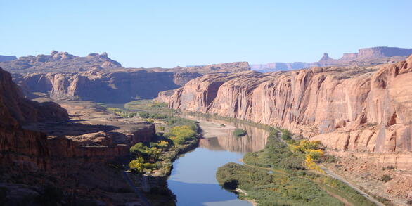
The Upper Colorado River Basin (UCRB) provides drinking water for 40 million people in the United States and Mexico. USGS research in the UCRB examines the key potential factors affecting water supply in the upper portion of the basin—snow processes and water storage, wildfire and basin hydrology, and salinity concentrations and water quality.
In 2019, the USGS selected the Upper Colorado River Basin (UCRB) as the second of up to ten planned Integrated Water Science (IWS) basins. The UCRB was chosen because it represents the importance of snow conditions to water availability for human and ecosystem use.
The Colorado River Basin is an important water source for more than 40 million people in the Western United States and Mexico, providing water to major cities and irrigating agricultural land. However, since 2000, the region has faced prolonged drought conditions, leading to record low levels in Lake Mead and Lake Powell and resulting in water usage restrictions.
The USGS plays a key role in studying the Colorado River Basin water supply. Understanding the processes that can affect water supply in the upper portion of the basin could be crucial for supporting human, agricultural, and ecological needs across a large spatial scale.
The UCRB IWS effort is planned to span 10 years and is divided into two phases:
Phase 1 (2021–2025) is focused on understanding how snow accumulation and melt processes contribute to water availability and total dissolved solids (salinity) concentrations and loads.
Phase 2 (2026–2030) will focus on a broader evaluation of water availability in the region.
The UCRB Next Generation Water Observing System (NGWOS) effort is planned to span 10 years and is divided into three phases.
Phase 1 (2019—2020) focused on identifying existing tools and data, stakeholder input, and strategic planning.
Phase 2 (2021-2023) focused on installation of new NGWOS monitoring equipment and instrumentation, develop data connections, and continued research and development.
Phase 3 (2024-2028) is focused on continued operation and maintenance of NGWOS deployments.
The Colorado River and its tributaries supply drinking water for 40 million people in the U.S. and Mexico, irrigation water for 5.5 million acres of land, and are essential sources of water for at least 29 federally recognized tribes, 7 National Wildlife Refuges, 4 National Recreation Areas, and 11 National Parks. The Colorado River Compact of 1922 divided the Colorado River into upper and lower basins at Lees Ferry, Arizona. The Compact divides water in the Colorado River equally between the upper and lower basin states, with each basin receiving 7.5 million acre-feet (maf) per year. An additional 1.5 maf per year of Colorado River water is guaranteed to Mexico, per a 1944 treaty.
The water in the Colorado River was apportioned based on hydrologic data that are now known to have been collected during an unusually wet period in the upper basin. Present day normal flow conditions may not produce sufficient water for all apportioned uses. Extended drought and patterns of aridification in the basin may have a profound effect on resulting streamflow and resulting reservoir storage in the UCRB. These issues are likely to create challenges for water managers to deliver on compact and treaty agreements. The IWS work will provide basin stakeholders and managers with an improved understanding of past, current, and future water supply that is needed to determine if there will be enough water of suitable quality to meet a multitude of human and ecosystem demands.
A Water Isotope Network precipitation collector at the USGS meteorological station site at Lake Irwin near Ruby Anthracite Creek, Colorado in October 2023.
UCRB Hydrography and Water Availability
The primary sources of water in the UCRB are the annual winter snowpack in the mountains and the resulting spring snowmelt that flows down through tributaries of the Colorado River. High-altitude areas are cold enough to receive most of their precipitation as winter snow that accumulates as a seasonal snowpack. These areas produce a large portion of the runoff to streams in the basin: about 15 percent of the basin area contributes about 85 percent of the mean-annual runoff. Changes in weather patterns are affecting the amount of snow accumulation, the timing of snow melt, and the relative contribution of precipitation that falls as rain versus snow.
The effect of salinity, or dissolved solids, on water availability for human and ecosystem use is also a major concern in the Colorado River Basin in both the United States and Mexico, with quantified damages estimated to be about \$447 million per year at 2023 salinity concentrations. These economic damages are mostly from corrosion and reduced agricultural yields. The Colorado River is naturally saline because of the underlying geology and arid climate, although both natural and human sources contribute to the river's salinity levels. Recent work suggests that groundwater is a critical resource for sustaining streamflow as well as a source of salinity.
Because groundwater and surface water are a single, interconnected resource, future management practices that collectively manage groundwater and surface water may be required to maximize available water in the basin. Changes in water supply and demand in the basin, including a 20-plus year ongoing drought, are expected to continue in the future, and projecting the effects of these changes on water availability will help inform future water planning efforts to meet human and ecosystem needs.
Overview of UCRB Research Priorities and Plans
With so many people relying on water from the Colorado River, studying the UCRB is important for a variety of reasons--and no issue affects UCRB communities more than better defining snowmelt runoff. Snow accumulation is the primary source of water availability in the Colorado River basin, driving streamflow, salinity transport and storage, and stream temperature.
USGS scientists aim to improve our understanding of how snow accumulation and melt processes contribute to surface and groundwater availability (quantity and dissolved solids) for human and ecological use as environmental conditions change.
A rainstorm at Cataract Canyon on the Colorado River as it enters Lake Powell in June 2024.
Regional Water Availability Assessments are scientific assessments of water availability in different hydrologic regions across the Nation. In the UCRB, the USGS is conducting a focused study of how snowpack and snowmelt influence hydrology and water quality as part of an integrated and comprehensive evaluation of multiple water quantity, quality, and use factors.
Regional Water Availability Assessments evaluate water quantity and quality in both surface and groundwater, determine whether there is enough water for human and ecosystem needs, and investigate how human and natural influences affect the amount of available water. Specifically, the Regional Water Availability Assessment research scientists in the UCRB are addressing questions such as:
How have changes in snowpack in the UCRB headwaters translated to changes in other water budget components throughout the basin and how will these changes vary in the future?
What is the sensitivity of total dissolved solids (like salt) concentrations and loads to changes in snow hydrology?
What factors affect water availability in the UCRB, including water quantity, quality, and use.
Two Uncrewed Aircraft System (UAS) fly in formation during the a snow water equivalent project in Winter Park Colorado. The ability to calculate centimeter-level snow depth measurements from remotely sensed data helps map snow conditions to better forecast snowmelt runoff in Colorado watersheds.
The NGWOS provides high-fidelity, real-time data on water quantity, quality, and use to support modern prediction and decision support systems that are necessary for informing water operations on a daily basis and decision-making during water emergencies.To better address how snowmelt affects the UCRB flow regime, NGWOS has expanded monitoring of snow, water temperature, streamflow, groundwater, and water quality in the Colorado River Headwaters & Gunnison River subbasins. These subbasins provide an opportunity to implement NGWOS in a snowmelt-dominated system in the mountain west.
Below are other projects associated with the Upper Colorado River IWS Basin
The U.S. Geological Survey is integrating its water science programs to better address the Nation’s greatest water resource challenges. At the heart of this effort are plans to intensively study several Integrated Water Science (IWS) basins—medium-sized watersheds (10,000-20,000 square miles) and underlying aquifers—over the next decade. The IWS basins will represent a wide range of environmental...
The U.S. Geological Survey is integrating its water science programs to better address the Nation’s greatest water resource challenges. At the heart of this effort are plans to intensively study several Integrated Water Science (IWS) basins—medium-sized watersheds (10,000-20,000 square miles) and underlying aquifers—over the next decade. The IWS basins will represent a wide range of environmental...
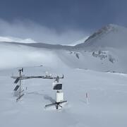
Representative observations of snowpack conditions are vital for informing water availability assessments and modeling in snow dominated regions of the western United States. The U.S. Geological Survey (USGS) established a snow hydrology monitoring network in 2021 with the objective of providing high-quality, representative, and publicly available data on snowpack, soil moisture, and...
Next Generation Water Observing System (NGWOS) Snow Hydrology Monitoring Network in the Upper Colorado River Basin
Representative observations of snowpack conditions are vital for informing water availability assessments and modeling in snow dominated regions of the western United States. The U.S. Geological Survey (USGS) established a snow hydrology monitoring network in 2021 with the objective of providing high-quality, representative, and publicly available data on snowpack, soil moisture, and...
Water availability is controlled by processes that can be hard to measure, like the process of groundwater discharging from a streambed that becomes streamflow. Naturally occurring, radioactive and stable (non-radioactive) isotopes can help trace those processes, particularly the isotopes of hydrogen and oxygen that are part of the water molecule. Tritium, the radioactive isotope of hydrogen, has...
Water availability is controlled by processes that can be hard to measure, like the process of groundwater discharging from a streambed that becomes streamflow. Naturally occurring, radioactive and stable (non-radioactive) isotopes can help trace those processes, particularly the isotopes of hydrogen and oxygen that are part of the water molecule. Tritium, the radioactive isotope of hydrogen, has...
The USGS Water Resources Mission Area is assessing how much water is available for human and ecological needs in the United States and identifying where and when the Nation may have challenges meeting its demand for water.
The USGS Water Resources Mission Area is assessing how much water is available for human and ecological needs in the United States and identifying where and when the Nation may have challenges meeting its demand for water.
The Grand Canyon Monitoring and Research Center, a branch of the Southwest Biological Science Center, conducts scientific assessments of the Colorado River in Grand Canyon, focused primarily on Lake Powell and the river ecosystem downstream of Glen Canyon Dam. On this page, we'd like to share related interactive tools and projects by other USGS Centers that cover science across the upper and lower...
The Grand Canyon Monitoring and Research Center, a branch of the Southwest Biological Science Center, conducts scientific assessments of the Colorado River in Grand Canyon, focused primarily on Lake Powell and the river ecosystem downstream of Glen Canyon Dam. On this page, we'd like to share related interactive tools and projects by other USGS Centers that cover science across the upper and lower...
Regional Water Availability Assessments are scientific assessments of water availability in different hydrologic regions across the Nation. In the Upper Colorado River Basin, the USGS will conduct a focused assessment of how snowpack and snowmelt influence hydrology and water quality, and an integrated and comprehensive assessment of multiple water quantity, quality and use factors.
Regional Water Availability Assessment: Upper Colorado River Basin
Regional Water Availability Assessments are scientific assessments of water availability in different hydrologic regions across the Nation. In the Upper Colorado River Basin, the USGS will conduct a focused assessment of how snowpack and snowmelt influence hydrology and water quality, and an integrated and comprehensive assessment of multiple water quantity, quality and use factors.
The Next Generation Water Observing System (NGWOS) provides high-fidelity, real-time data on water quantity, quality, and use to support modern prediction and decision-support systems that are necessary for informing water operations on a daily basis and decision-making during water emergencies. The headwaters of the Colorado and Gunnison River Basins provide an opportunity to implement NGWOS in a...
Next Generation Water Observing System: Upper Colorado River Basin
The Next Generation Water Observing System (NGWOS) provides high-fidelity, real-time data on water quantity, quality, and use to support modern prediction and decision-support systems that are necessary for informing water operations on a daily basis and decision-making during water emergencies. The headwaters of the Colorado and Gunnison River Basins provide an opportunity to implement NGWOS in a...
The Colorado River Basin is currently experiencing its worst drought in recorded history. The period from 2000 through 2020 is the driest 21-year period in over 100 years and one of the driest periods in the 1,200-year paleo-record. Drought impacts include worsening conditions in the 9 ecoregions, including habitat for several threatened and endangered species, wildland fire risks, reduced...
Colorado River Basin: Actionable and Strategic Integrated Science and Technology
The Colorado River Basin is currently experiencing its worst drought in recorded history. The period from 2000 through 2020 is the driest 21-year period in over 100 years and one of the driest periods in the 1,200-year paleo-record. Drought impacts include worsening conditions in the 9 ecoregions, including habitat for several threatened and endangered species, wildland fire risks, reduced...
This data release is focused on the analysis of surface water concentration data associated with 12 elements of concern from three hydrologic basins. Data is analyzed with respect to: a) reporting limits, b) the extent of censored data, c) co-location with USGS real-time sensor data, and d) median concentrations at the catchment spatial scale. The Proxies Project (under the Water Quality...
Salinity levels in streams and tributaries of the Colorado River Basin have been a major concern for years. Recently, the United States Geological Survey’s (USGS) Next Generation Water Observing System (NGWOS) program expanded stream monitoring networks including the number of sites where continuous (15-minute) specific conductance is measured in the Colorado River Headwaters and...
Identifying long-term trends in water availability, including surface water quantity, is a key part of the U.S. Geological Survey (USGS) Integrated Water Availability Assessments (IWAAs) mission. This data release includes input and output data used in Mann-Kendall trend analyses to characterize streamflow conditions at 124 USGS streamgages in the Upper Colorado River Basin for water...
This data release contains measured stream discharge and total dissolved solids (TDS) data and estimated values for daily stream TDS loads, daily baseflow discharge, and daily baseflow TDS loads for 205 locations in the Upper Colorado River Basin. The estimated values, which represent conditions between 10/1/1985 and 9/30/2020, were obtained using the Weighted Regressions on Time...
This data release contains an inventory of 1,358 major surface water diversion structures with associated daily time series withdrawal records (1980-2022) for structures within the Upper Colorado River and Little Colorado River Basins. Diversion structures were included in this dataset if they were determined to have the capacity to divert water at rates greater than 10 cubic feet per...
These data were compiled for/to estimate predicted pre-fire burn severity for estimating hazard of post-fire debris flow for conservation populations of blue-lineage Colorado River Cutthroat Trout. Objective(s) of our study were to predicted burn severity. These data represent predicted pre-fire differenced Normalized Burn Ratio (dNBR) for portions of Colorado, Utah, and Wyoming and were...
Acid mine drainage (AMD) can cause ecological harm throughout the state of Colorado, including in the Upper Animas River watershed near Silverton. In the Upper Animas River watershed, a technique that includes the emplacement of hydraulic bulkheads within draining mines has been used to remediate AMD. Data for major ions and trace metal concentrations, isotopic compositions, and...
This data release contains two sets of estimated values at selected sites within the Colorado River Basin: 1) daily specific conductance at 143 sites in the Upper Basin and 3 sites in the Lower Basin (WY 1980-2022); and 2) daily baseflow discharge at 100 sites in the Upper Basin and 3 sites in the Lower Basin (WY 1980-2022). The estimates of daily baseflow discharge will be used as input...
This data release contains total dissolved solids (TDS) concentrations and specific conductance (SC) measurements collected at surface-water monitoring locations and groundwater monitoring wells within the Upper Colorado River Basin (UCRB) between 1894 and 2022. Discrete TDS and SC results were obtained from the Water Quality Portal (WQP). Continuous SC monitoring results were obtained...
Note: this data release has been deprecated. Please see new data release here: https://doi.org/10.5066/P17LRYWZ This data release contains three sets of estimated values at selected sites within the Colorado River Basin: 1) daily specific conductance at 143 sites in the Upper Basin and 3 sites in the Lower Basin (WY 1980-2022); 2) daily baseflow discharge at 100 sites in the Upper Basin...
This data release consists of three child items distinguishing the following types of data: light detection and ranging (lidar) point clouds (LPCs), digital elevation models (DEMs), and snow depth raster maps. These three data types are all derived from lidar data collected on small, uncrewed aircraft systems (sUAS) at study areas in the Upper Colorado River Basin, Colorado, from 2020 to...
The U.S. Geological Survey developed a coupled groundwater and surface-water flow (GSFLOW) model to represent the aquifers of the Colorado Plateau and Upper Colorado River Basin. The study area covers approximately 142,000 square miles and includes parts of Arizona, Colorado, New Mexico, Utah, and Wyoming. To support this modeling effort, groundwater well withdrawal volume data were...
This recorded webinar details the significance and finding of the National Water Availability Assessment Release. This new assessment is the first of its kind, offering new insights on where there is a potential imbalance between water supply and demand in the United States. The assessment uses state-of-the-art models to fill in gaps between monitoring sites and sampling events and integrates...
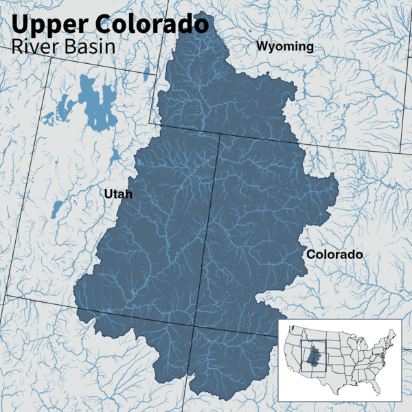
Map of Upper Colorado River Basin - Integrated Water Availability
Map of the Upper Colorado River Basin —referred to as an Integrated Water Science (IWS) basins—are intensively monitored study basins representing a wide range of environmental, hydrologic, and landscape settings and human stressors of water resources to improve our understanding of water availability across the Nation.
Map of the Upper Colorado River Basin —referred to as an Integrated Water Science (IWS) basins—are intensively monitored study basins representing a wide range of environmental, hydrologic, and landscape settings and human stressors of water resources to improve our understanding of water availability across the Nation.
Selected reference basins (darker shaded basins)—referred to as Integrated Water Science (IWS) basins—are intensively monitored study basins representing a wide range of environmental, hydrologic, and landscape settings and human stressors of water resources to improve our understanding of water availability across the Nation.
Selected reference basins (darker shaded basins)—referred to as Integrated Water Science (IWS) basins—are intensively monitored study basins representing a wide range of environmental, hydrologic, and landscape settings and human stressors of water resources to improve our understanding of water availability across the Nation.
Map showing the major tritium-monitoring sites in the NGWOS study area of the Upper Colorado River Basin where Water Isotope Network samples of precipitation and streamflow are collected, as well as sites where snowpack samples are collected for comparison to total precipitation.
Map showing the major tritium-monitoring sites in the NGWOS study area of the Upper Colorado River Basin where Water Isotope Network samples of precipitation and streamflow are collected, as well as sites where snowpack samples are collected for comparison to total precipitation.
Illustration of Colorado River Basin, showing upper and lower basins
Illustration of Colorado River Basin, showing upper and lower basins with a red text box around the Colorado River in Grand Canyon. Reduced-size map of the Colorado River Basin from the USGS ASIST Initiative, Sept. 3, 2024.
Illustration of Colorado River Basin, showing upper and lower basins with a red text box around the Colorado River in Grand Canyon. Reduced-size map of the Colorado River Basin from the USGS ASIST Initiative, Sept. 3, 2024.
Upper Colorado River Basin streamflow, March-August 2023
March-August daily average streamflow for the last 30 years (1991-2022) (dark gray lines) compared to 2023, showing the periods where 2023 streamflow was above (blue) and below (orange) the historical average. Individual years of the relevant historical streamflow period are shown in light gray.
March-August daily average streamflow for the last 30 years (1991-2022) (dark gray lines) compared to 2023, showing the periods where 2023 streamflow was above (blue) and below (orange) the historical average. Individual years of the relevant historical streamflow period are shown in light gray.
Next Generation Water Observing System Conceptual Diagram
Conceptual illustration showing how USGS's Next Generation Water Observing System will enhance the spatial and temporal monitoring of water within reference basins and larger hydrologic regions in all U.S. states and territories.
Conceptual illustration showing how USGS's Next Generation Water Observing System will enhance the spatial and temporal monitoring of water within reference basins and larger hydrologic regions in all U.S. states and territories.
40+ Years of Streamflow Drought in the Upper Colorado River Basin
A time series of streamflow drought events occurring across 122 stream gages in the Upper Colorado River basin from 1980 to present. Periods of streamflow drought are indicated for each of 122 gages in a beeswarm-like chart, with time on the x-axis. During time periods where many gages experienced drought, the swarm bulges due to many co-occurring events.
A time series of streamflow drought events occurring across 122 stream gages in the Upper Colorado River basin from 1980 to present. Periods of streamflow drought are indicated for each of 122 gages in a beeswarm-like chart, with time on the x-axis. During time periods where many gages experienced drought, the swarm bulges due to many co-occurring events.
Ecological site group map for the Upper Colorado River Basin
An ecological site group map for the Upper Colorado River Basin that displays a quantitative soil-geomorphic framework in the Four Corners region, USA.
An ecological site group map for the Upper Colorado River Basin that displays a quantitative soil-geomorphic framework in the Four Corners region, USA.
Salinity levels in streams and tributaries of the Colorado River Basin have been a major concern for the United States and Mexico for over 50 years as the water is used by millions of people for domestic and industrial purposes. Recently, the United States Geological Survey expanded stream monitoring networks including the number of sites where continuous (15-min) specific conductance is...
Authors
R. Blaine McCleskey, Charles A. Cravotta, Matthew P. Miller, Tanner William Chapin, Fred D. Tillman, Gabrielle L. Keith
This professional paper is a multichapter report that assesses water availability in the United States for water years 2010–20. This work was conducted as part of the fulfillment of the mandates of Subtitle F of the Omnibus Public Land Management Act of 2009 (Public Law 111-11), also known as the SECURE Water Act. As such, this work examines the spatial and temporal distribution of water...
The Colorado River is an important water source in the southwestern United States and northern Mexico. High concentrations of dissolved solids in the river, sourced mainly from the Upper Colorado River Basin (UCOL), cause hundreds of millions of dollars in damages annually to crops and infrastructure. Determinations of total dissolved solids (TDS) in river and tributary samples often...
Authors
Fred D. Tillman, Matthew P. Miller, Daniel R. Wise, R. Blaine McCleskey, Natalie K. Day
The Colorado River drains about 8% of the conterminous United States, provides water for 40 million people, and is one of the most overallocated rivers in the world. As the upper Colorado River Basin (UCOL) contributes an estimated 92% of the total basin natural streamflow, knowledge of the location and amount of surface water withdrawals in the UCOL is important for managing the...
Authors
Samuel Francisco Lopez, Jacob E. Knight, Fred D. Tillman, Melissa D. Masbruch, Daniel R. Wise, Casey J.R. Jones, Matthew P. Miller
Background Colorado River Cutthroat Trout (CRCT; Oncorhynchus clarkii pleuriticus) conservation populations may be at risk from wildfire and post-fire debris flows hazards. Aim To predict burn severity and potential post-fire debris flow hazard classifications to CRCT conservation populations before wildfires occur. Methods We used remote sensing, spatial analyses, and machine learning...
Authors
Adam Gerhard Wells, Charles B. Yackulic, Jaime Kostelnik, Andrew R. Bock, Robert E. Zuellig, Daren M. Carlisle, James J. Roberts, Kevin B. Rogers, Seth M. Munson
Discharge of deeply sourced groundwater to streams is difficult to locate and quantify, particularly where both discrete and diffuse discharge points exist, but diffuse discharge is one of the primary controls on solute budgets in mountainous watersheds. The noble gas helium is a unique identifier of deep groundwater discharge because groundwater with long residence times is commonly...
Authors
Connor P. Newman, Eric Humphrey, Matthias Brennwald, W. Payton Gardner, Kelli M. Palko, Michael Gooseff, Kip Solomon
About 80 % of the precipitation at the Colorado River's headwaters is snow, and the resulting snowmelt-driven hydrograph is a crucial water source for about 40 million people. Snowmelt from alpine and subalpine snowpack contributes substantially to groundwater recharge and river flow. However, the dynamics of snowmelt progression are not well understood because observations of the high...
Authors
Matthias Sprenger, Rosemary W.H. Carroll, David W Marchetti, Carleton R. Bern, Harsh Beria, Wendy Brown, Alexander Newman, Curtis Beutler, Kenneth H. Williams
Freshwater salinization is a growing global concern impacting human and ecosystem needs with impacts to water availability for human and ecological uses. In the Upper Colorado River Basin (UCRB), dissolved solids in streams compound ongoing water supply challenges to further limit water availability and cause economic damages. Much effort has been dedicated to understanding dissolved...
Authors
Olivia L. Miller, Annie L. Putman, Richard A. Smith, Gregory E. Schwarz, Michael D. Hess, Morgan C. McDonnell, Daniel K. Jones
Water availability is a result of complex interactions between regional water supply and demand and underlying environmental, institutional, and economic determinants. For this study, water availability is defined as “access to a specific quantity and quality of water at a point in time and space, for a specific use, recognizing the social and economic value of water across uses and...
Authors
Nicole M. Herman-Mercer, Lucas Bair, Megan Hines, Diana Restrepo-Osorio, Veronica Romero, Aidan Lyde
Continued climate warming is reducing seasonal snowpacks in the western United States, where >50% of historical water supplies were snowmelt-derived. In the Upper Colorado River Basin, declining snow water equivalent (SWE) and altered surface water input (SWI, rainfall and snowmelt available to enter the soil) timing and magnitude affect streamflow generation and water availability. To...
Authors
John C. Hammond, Graham A. Sexstone, Annie L. Putman, Theodore B. Barnhart, David M. Rey, Jessica M. Driscoll, Glen Liston, Kristen L. Rasmussen, Daniel McGrath, Steven R. Fassnacht, Stephanie K. Kampf
The Colorado River is a critical water resource in the southwestern United States, supplying drinking water for 40 million people in the region and water for irrigation of 2.2 million hectares of land. Extended drought in the Upper Colorado River Basin (UCOL) and the prospect of a warmer climate in the future pose water availability challenges for those charged with managing the river...
Authors
Fred D. Tillman, Natalie K. Day, Matthew P. Miller, Olivia L. Miller, Christine Rumsey, Daniel R. Wise, Patrick C. Longley, Morgan C. McDonnell
Baseflow is critical to sustaining streamflow in the Upper Colorado River Basin. Therefore, effective water resources management requires estimates of baseflow response to climatic changes. This study provides the first estimates of projected baseflow changes from historical (1984 – 2012) to thirty-year periods centered around 2030, 2050, and 2080 under warm/wet, median, and hot/dry...
Authors
Olivia L. Miller, Matthew P. Miller, Patrick C. Longley, Jay R. Alder, Lindsay A. Bearup, Tom Pruitt, Daniel K. Jones, Annie L. Putman, Christine Rumsey, Tim S. McKinney
This interactive website highlights key scientific findings of the National Water Availability Assessment report through engaging stories, plain-language explanations, and interactive data visualizations.
A majority of the water in the western U.S. comes from snowmelt, but changes in the timing, magnitude, and duration of snowmelt can alter water availability downstream. This data visualization story explores what changing snowmelt means for water in the West, and how new USGS efforts can advance snow science by modeling snowpack and snowmelt dynamics and linking these results to streamflow.
The U.S. Geological Survey has chosen the Illinois River Basin as the next watershed to be studied by its scientists as part of a large-scale effort to better understand the nation’s water systems.
The Upper Colorado River Basin (UCRB) provides drinking water for 40 million people in the United States and Mexico. USGS research in the UCRB examines the key potential factors affecting water supply in the upper portion of the basin—snow processes and water storage, wildfire and basin hydrology, and salinity concentrations and water quality.
In 2019, the USGS selected the Upper Colorado River Basin (UCRB) as the second of up to ten planned Integrated Water Science (IWS) basins. The UCRB was chosen because it represents the importance of snow conditions to water availability for human and ecosystem use.
The Colorado River Basin is an important water source for more than 40 million people in the Western United States and Mexico, providing water to major cities and irrigating agricultural land. However, since 2000, the region has faced prolonged drought conditions, leading to record low levels in Lake Mead and Lake Powell and resulting in water usage restrictions.
The USGS plays a key role in studying the Colorado River Basin water supply. Understanding the processes that can affect water supply in the upper portion of the basin could be crucial for supporting human, agricultural, and ecological needs across a large spatial scale.
The UCRB IWS effort is planned to span 10 years and is divided into two phases:
Phase 1 (2021–2025) is focused on understanding how snow accumulation and melt processes contribute to water availability and total dissolved solids (salinity) concentrations and loads.
Phase 2 (2026–2030) will focus on a broader evaluation of water availability in the region.
The UCRB Next Generation Water Observing System (NGWOS) effort is planned to span 10 years and is divided into three phases.
Phase 1 (2019—2020) focused on identifying existing tools and data, stakeholder input, and strategic planning.
Phase 2 (2021-2023) focused on installation of new NGWOS monitoring equipment and instrumentation, develop data connections, and continued research and development.
Phase 3 (2024-2028) is focused on continued operation and maintenance of NGWOS deployments.
The Colorado River and its tributaries supply drinking water for 40 million people in the U.S. and Mexico, irrigation water for 5.5 million acres of land, and are essential sources of water for at least 29 federally recognized tribes, 7 National Wildlife Refuges, 4 National Recreation Areas, and 11 National Parks. The Colorado River Compact of 1922 divided the Colorado River into upper and lower basins at Lees Ferry, Arizona. The Compact divides water in the Colorado River equally between the upper and lower basin states, with each basin receiving 7.5 million acre-feet (maf) per year. An additional 1.5 maf per year of Colorado River water is guaranteed to Mexico, per a 1944 treaty.
The water in the Colorado River was apportioned based on hydrologic data that are now known to have been collected during an unusually wet period in the upper basin. Present day normal flow conditions may not produce sufficient water for all apportioned uses. Extended drought and patterns of aridification in the basin may have a profound effect on resulting streamflow and resulting reservoir storage in the UCRB. These issues are likely to create challenges for water managers to deliver on compact and treaty agreements. The IWS work will provide basin stakeholders and managers with an improved understanding of past, current, and future water supply that is needed to determine if there will be enough water of suitable quality to meet a multitude of human and ecosystem demands.
A Water Isotope Network precipitation collector at the USGS meteorological station site at Lake Irwin near Ruby Anthracite Creek, Colorado in October 2023.
UCRB Hydrography and Water Availability
The primary sources of water in the UCRB are the annual winter snowpack in the mountains and the resulting spring snowmelt that flows down through tributaries of the Colorado River. High-altitude areas are cold enough to receive most of their precipitation as winter snow that accumulates as a seasonal snowpack. These areas produce a large portion of the runoff to streams in the basin: about 15 percent of the basin area contributes about 85 percent of the mean-annual runoff. Changes in weather patterns are affecting the amount of snow accumulation, the timing of snow melt, and the relative contribution of precipitation that falls as rain versus snow.
The effect of salinity, or dissolved solids, on water availability for human and ecosystem use is also a major concern in the Colorado River Basin in both the United States and Mexico, with quantified damages estimated to be about \$447 million per year at 2023 salinity concentrations. These economic damages are mostly from corrosion and reduced agricultural yields. The Colorado River is naturally saline because of the underlying geology and arid climate, although both natural and human sources contribute to the river's salinity levels. Recent work suggests that groundwater is a critical resource for sustaining streamflow as well as a source of salinity.
Because groundwater and surface water are a single, interconnected resource, future management practices that collectively manage groundwater and surface water may be required to maximize available water in the basin. Changes in water supply and demand in the basin, including a 20-plus year ongoing drought, are expected to continue in the future, and projecting the effects of these changes on water availability will help inform future water planning efforts to meet human and ecosystem needs.
Overview of UCRB Research Priorities and Plans
With so many people relying on water from the Colorado River, studying the UCRB is important for a variety of reasons--and no issue affects UCRB communities more than better defining snowmelt runoff. Snow accumulation is the primary source of water availability in the Colorado River basin, driving streamflow, salinity transport and storage, and stream temperature.
USGS scientists aim to improve our understanding of how snow accumulation and melt processes contribute to surface and groundwater availability (quantity and dissolved solids) for human and ecological use as environmental conditions change.
A rainstorm at Cataract Canyon on the Colorado River as it enters Lake Powell in June 2024.
Regional Water Availability Assessments are scientific assessments of water availability in different hydrologic regions across the Nation. In the UCRB, the USGS is conducting a focused study of how snowpack and snowmelt influence hydrology and water quality as part of an integrated and comprehensive evaluation of multiple water quantity, quality, and use factors.
Regional Water Availability Assessments evaluate water quantity and quality in both surface and groundwater, determine whether there is enough water for human and ecosystem needs, and investigate how human and natural influences affect the amount of available water. Specifically, the Regional Water Availability Assessment research scientists in the UCRB are addressing questions such as:
How have changes in snowpack in the UCRB headwaters translated to changes in other water budget components throughout the basin and how will these changes vary in the future?
What is the sensitivity of total dissolved solids (like salt) concentrations and loads to changes in snow hydrology?
What factors affect water availability in the UCRB, including water quantity, quality, and use.
Two Uncrewed Aircraft System (UAS) fly in formation during the a snow water equivalent project in Winter Park Colorado. The ability to calculate centimeter-level snow depth measurements from remotely sensed data helps map snow conditions to better forecast snowmelt runoff in Colorado watersheds.
The NGWOS provides high-fidelity, real-time data on water quantity, quality, and use to support modern prediction and decision support systems that are necessary for informing water operations on a daily basis and decision-making during water emergencies.To better address how snowmelt affects the UCRB flow regime, NGWOS has expanded monitoring of snow, water temperature, streamflow, groundwater, and water quality in the Colorado River Headwaters & Gunnison River subbasins. These subbasins provide an opportunity to implement NGWOS in a snowmelt-dominated system in the mountain west.
Below are other projects associated with the Upper Colorado River IWS Basin
The U.S. Geological Survey is integrating its water science programs to better address the Nation’s greatest water resource challenges. At the heart of this effort are plans to intensively study several Integrated Water Science (IWS) basins—medium-sized watersheds (10,000-20,000 square miles) and underlying aquifers—over the next decade. The IWS basins will represent a wide range of environmental...
The U.S. Geological Survey is integrating its water science programs to better address the Nation’s greatest water resource challenges. At the heart of this effort are plans to intensively study several Integrated Water Science (IWS) basins—medium-sized watersheds (10,000-20,000 square miles) and underlying aquifers—over the next decade. The IWS basins will represent a wide range of environmental...
Representative observations of snowpack conditions are vital for informing water availability assessments and modeling in snow dominated regions of the western United States. The U.S. Geological Survey (USGS) established a snow hydrology monitoring network in 2021 with the objective of providing high-quality, representative, and publicly available data on snowpack, soil moisture, and...
Next Generation Water Observing System (NGWOS) Snow Hydrology Monitoring Network in the Upper Colorado River Basin
Representative observations of snowpack conditions are vital for informing water availability assessments and modeling in snow dominated regions of the western United States. The U.S. Geological Survey (USGS) established a snow hydrology monitoring network in 2021 with the objective of providing high-quality, representative, and publicly available data on snowpack, soil moisture, and...
Water availability is controlled by processes that can be hard to measure, like the process of groundwater discharging from a streambed that becomes streamflow. Naturally occurring, radioactive and stable (non-radioactive) isotopes can help trace those processes, particularly the isotopes of hydrogen and oxygen that are part of the water molecule. Tritium, the radioactive isotope of hydrogen, has...
Water availability is controlled by processes that can be hard to measure, like the process of groundwater discharging from a streambed that becomes streamflow. Naturally occurring, radioactive and stable (non-radioactive) isotopes can help trace those processes, particularly the isotopes of hydrogen and oxygen that are part of the water molecule. Tritium, the radioactive isotope of hydrogen, has...
The USGS Water Resources Mission Area is assessing how much water is available for human and ecological needs in the United States and identifying where and when the Nation may have challenges meeting its demand for water.
The USGS Water Resources Mission Area is assessing how much water is available for human and ecological needs in the United States and identifying where and when the Nation may have challenges meeting its demand for water.
The Grand Canyon Monitoring and Research Center, a branch of the Southwest Biological Science Center, conducts scientific assessments of the Colorado River in Grand Canyon, focused primarily on Lake Powell and the river ecosystem downstream of Glen Canyon Dam. On this page, we'd like to share related interactive tools and projects by other USGS Centers that cover science across the upper and lower...
The Grand Canyon Monitoring and Research Center, a branch of the Southwest Biological Science Center, conducts scientific assessments of the Colorado River in Grand Canyon, focused primarily on Lake Powell and the river ecosystem downstream of Glen Canyon Dam. On this page, we'd like to share related interactive tools and projects by other USGS Centers that cover science across the upper and lower...
Regional Water Availability Assessments are scientific assessments of water availability in different hydrologic regions across the Nation. In the Upper Colorado River Basin, the USGS will conduct a focused assessment of how snowpack and snowmelt influence hydrology and water quality, and an integrated and comprehensive assessment of multiple water quantity, quality and use factors.
Regional Water Availability Assessment: Upper Colorado River Basin
Regional Water Availability Assessments are scientific assessments of water availability in different hydrologic regions across the Nation. In the Upper Colorado River Basin, the USGS will conduct a focused assessment of how snowpack and snowmelt influence hydrology and water quality, and an integrated and comprehensive assessment of multiple water quantity, quality and use factors.
The Next Generation Water Observing System (NGWOS) provides high-fidelity, real-time data on water quantity, quality, and use to support modern prediction and decision-support systems that are necessary for informing water operations on a daily basis and decision-making during water emergencies. The headwaters of the Colorado and Gunnison River Basins provide an opportunity to implement NGWOS in a...
Next Generation Water Observing System: Upper Colorado River Basin
The Next Generation Water Observing System (NGWOS) provides high-fidelity, real-time data on water quantity, quality, and use to support modern prediction and decision-support systems that are necessary for informing water operations on a daily basis and decision-making during water emergencies. The headwaters of the Colorado and Gunnison River Basins provide an opportunity to implement NGWOS in a...
The Colorado River Basin is currently experiencing its worst drought in recorded history. The period from 2000 through 2020 is the driest 21-year period in over 100 years and one of the driest periods in the 1,200-year paleo-record. Drought impacts include worsening conditions in the 9 ecoregions, including habitat for several threatened and endangered species, wildland fire risks, reduced...
Colorado River Basin: Actionable and Strategic Integrated Science and Technology
The Colorado River Basin is currently experiencing its worst drought in recorded history. The period from 2000 through 2020 is the driest 21-year period in over 100 years and one of the driest periods in the 1,200-year paleo-record. Drought impacts include worsening conditions in the 9 ecoregions, including habitat for several threatened and endangered species, wildland fire risks, reduced...
This data release is focused on the analysis of surface water concentration data associated with 12 elements of concern from three hydrologic basins. Data is analyzed with respect to: a) reporting limits, b) the extent of censored data, c) co-location with USGS real-time sensor data, and d) median concentrations at the catchment spatial scale. The Proxies Project (under the Water Quality...
Salinity levels in streams and tributaries of the Colorado River Basin have been a major concern for years. Recently, the United States Geological Survey’s (USGS) Next Generation Water Observing System (NGWOS) program expanded stream monitoring networks including the number of sites where continuous (15-minute) specific conductance is measured in the Colorado River Headwaters and...
Identifying long-term trends in water availability, including surface water quantity, is a key part of the U.S. Geological Survey (USGS) Integrated Water Availability Assessments (IWAAs) mission. This data release includes input and output data used in Mann-Kendall trend analyses to characterize streamflow conditions at 124 USGS streamgages in the Upper Colorado River Basin for water...
This data release contains measured stream discharge and total dissolved solids (TDS) data and estimated values for daily stream TDS loads, daily baseflow discharge, and daily baseflow TDS loads for 205 locations in the Upper Colorado River Basin. The estimated values, which represent conditions between 10/1/1985 and 9/30/2020, were obtained using the Weighted Regressions on Time...
This data release contains an inventory of 1,358 major surface water diversion structures with associated daily time series withdrawal records (1980-2022) for structures within the Upper Colorado River and Little Colorado River Basins. Diversion structures were included in this dataset if they were determined to have the capacity to divert water at rates greater than 10 cubic feet per...
These data were compiled for/to estimate predicted pre-fire burn severity for estimating hazard of post-fire debris flow for conservation populations of blue-lineage Colorado River Cutthroat Trout. Objective(s) of our study were to predicted burn severity. These data represent predicted pre-fire differenced Normalized Burn Ratio (dNBR) for portions of Colorado, Utah, and Wyoming and were...
Acid mine drainage (AMD) can cause ecological harm throughout the state of Colorado, including in the Upper Animas River watershed near Silverton. In the Upper Animas River watershed, a technique that includes the emplacement of hydraulic bulkheads within draining mines has been used to remediate AMD. Data for major ions and trace metal concentrations, isotopic compositions, and...
This data release contains two sets of estimated values at selected sites within the Colorado River Basin: 1) daily specific conductance at 143 sites in the Upper Basin and 3 sites in the Lower Basin (WY 1980-2022); and 2) daily baseflow discharge at 100 sites in the Upper Basin and 3 sites in the Lower Basin (WY 1980-2022). The estimates of daily baseflow discharge will be used as input...
This data release contains total dissolved solids (TDS) concentrations and specific conductance (SC) measurements collected at surface-water monitoring locations and groundwater monitoring wells within the Upper Colorado River Basin (UCRB) between 1894 and 2022. Discrete TDS and SC results were obtained from the Water Quality Portal (WQP). Continuous SC monitoring results were obtained...
Note: this data release has been deprecated. Please see new data release here: https://doi.org/10.5066/P17LRYWZ This data release contains three sets of estimated values at selected sites within the Colorado River Basin: 1) daily specific conductance at 143 sites in the Upper Basin and 3 sites in the Lower Basin (WY 1980-2022); 2) daily baseflow discharge at 100 sites in the Upper Basin...
This data release consists of three child items distinguishing the following types of data: light detection and ranging (lidar) point clouds (LPCs), digital elevation models (DEMs), and snow depth raster maps. These three data types are all derived from lidar data collected on small, uncrewed aircraft systems (sUAS) at study areas in the Upper Colorado River Basin, Colorado, from 2020 to...
The U.S. Geological Survey developed a coupled groundwater and surface-water flow (GSFLOW) model to represent the aquifers of the Colorado Plateau and Upper Colorado River Basin. The study area covers approximately 142,000 square miles and includes parts of Arizona, Colorado, New Mexico, Utah, and Wyoming. To support this modeling effort, groundwater well withdrawal volume data were...
This recorded webinar details the significance and finding of the National Water Availability Assessment Release. This new assessment is the first of its kind, offering new insights on where there is a potential imbalance between water supply and demand in the United States. The assessment uses state-of-the-art models to fill in gaps between monitoring sites and sampling events and integrates...
Map of Upper Colorado River Basin - Integrated Water Availability
Map of the Upper Colorado River Basin —referred to as an Integrated Water Science (IWS) basins—are intensively monitored study basins representing a wide range of environmental, hydrologic, and landscape settings and human stressors of water resources to improve our understanding of water availability across the Nation.
Map of the Upper Colorado River Basin —referred to as an Integrated Water Science (IWS) basins—are intensively monitored study basins representing a wide range of environmental, hydrologic, and landscape settings and human stressors of water resources to improve our understanding of water availability across the Nation.
Selected reference basins (darker shaded basins)—referred to as Integrated Water Science (IWS) basins—are intensively monitored study basins representing a wide range of environmental, hydrologic, and landscape settings and human stressors of water resources to improve our understanding of water availability across the Nation.
Selected reference basins (darker shaded basins)—referred to as Integrated Water Science (IWS) basins—are intensively monitored study basins representing a wide range of environmental, hydrologic, and landscape settings and human stressors of water resources to improve our understanding of water availability across the Nation.
Map showing the major tritium-monitoring sites in the NGWOS study area of the Upper Colorado River Basin where Water Isotope Network samples of precipitation and streamflow are collected, as well as sites where snowpack samples are collected for comparison to total precipitation.
Map showing the major tritium-monitoring sites in the NGWOS study area of the Upper Colorado River Basin where Water Isotope Network samples of precipitation and streamflow are collected, as well as sites where snowpack samples are collected for comparison to total precipitation.
Illustration of Colorado River Basin, showing upper and lower basins
Illustration of Colorado River Basin, showing upper and lower basins with a red text box around the Colorado River in Grand Canyon. Reduced-size map of the Colorado River Basin from the USGS ASIST Initiative, Sept. 3, 2024.
Illustration of Colorado River Basin, showing upper and lower basins with a red text box around the Colorado River in Grand Canyon. Reduced-size map of the Colorado River Basin from the USGS ASIST Initiative, Sept. 3, 2024.
Upper Colorado River Basin streamflow, March-August 2023
March-August daily average streamflow for the last 30 years (1991-2022) (dark gray lines) compared to 2023, showing the periods where 2023 streamflow was above (blue) and below (orange) the historical average. Individual years of the relevant historical streamflow period are shown in light gray.
March-August daily average streamflow for the last 30 years (1991-2022) (dark gray lines) compared to 2023, showing the periods where 2023 streamflow was above (blue) and below (orange) the historical average. Individual years of the relevant historical streamflow period are shown in light gray.
Next Generation Water Observing System Conceptual Diagram
Conceptual illustration showing how USGS's Next Generation Water Observing System will enhance the spatial and temporal monitoring of water within reference basins and larger hydrologic regions in all U.S. states and territories.
Conceptual illustration showing how USGS's Next Generation Water Observing System will enhance the spatial and temporal monitoring of water within reference basins and larger hydrologic regions in all U.S. states and territories.
40+ Years of Streamflow Drought in the Upper Colorado River Basin
A time series of streamflow drought events occurring across 122 stream gages in the Upper Colorado River basin from 1980 to present. Periods of streamflow drought are indicated for each of 122 gages in a beeswarm-like chart, with time on the x-axis. During time periods where many gages experienced drought, the swarm bulges due to many co-occurring events.
A time series of streamflow drought events occurring across 122 stream gages in the Upper Colorado River basin from 1980 to present. Periods of streamflow drought are indicated for each of 122 gages in a beeswarm-like chart, with time on the x-axis. During time periods where many gages experienced drought, the swarm bulges due to many co-occurring events.
Ecological site group map for the Upper Colorado River Basin
An ecological site group map for the Upper Colorado River Basin that displays a quantitative soil-geomorphic framework in the Four Corners region, USA.
An ecological site group map for the Upper Colorado River Basin that displays a quantitative soil-geomorphic framework in the Four Corners region, USA.
Salinity levels in streams and tributaries of the Colorado River Basin have been a major concern for the United States and Mexico for over 50 years as the water is used by millions of people for domestic and industrial purposes. Recently, the United States Geological Survey expanded stream monitoring networks including the number of sites where continuous (15-min) specific conductance is...
Authors
R. Blaine McCleskey, Charles A. Cravotta, Matthew P. Miller, Tanner William Chapin, Fred D. Tillman, Gabrielle L. Keith
This professional paper is a multichapter report that assesses water availability in the United States for water years 2010–20. This work was conducted as part of the fulfillment of the mandates of Subtitle F of the Omnibus Public Land Management Act of 2009 (Public Law 111-11), also known as the SECURE Water Act. As such, this work examines the spatial and temporal distribution of water...
The Colorado River is an important water source in the southwestern United States and northern Mexico. High concentrations of dissolved solids in the river, sourced mainly from the Upper Colorado River Basin (UCOL), cause hundreds of millions of dollars in damages annually to crops and infrastructure. Determinations of total dissolved solids (TDS) in river and tributary samples often...
Authors
Fred D. Tillman, Matthew P. Miller, Daniel R. Wise, R. Blaine McCleskey, Natalie K. Day
The Colorado River drains about 8% of the conterminous United States, provides water for 40 million people, and is one of the most overallocated rivers in the world. As the upper Colorado River Basin (UCOL) contributes an estimated 92% of the total basin natural streamflow, knowledge of the location and amount of surface water withdrawals in the UCOL is important for managing the...
Authors
Samuel Francisco Lopez, Jacob E. Knight, Fred D. Tillman, Melissa D. Masbruch, Daniel R. Wise, Casey J.R. Jones, Matthew P. Miller
Background Colorado River Cutthroat Trout (CRCT; Oncorhynchus clarkii pleuriticus) conservation populations may be at risk from wildfire and post-fire debris flows hazards. Aim To predict burn severity and potential post-fire debris flow hazard classifications to CRCT conservation populations before wildfires occur. Methods We used remote sensing, spatial analyses, and machine learning...
Authors
Adam Gerhard Wells, Charles B. Yackulic, Jaime Kostelnik, Andrew R. Bock, Robert E. Zuellig, Daren M. Carlisle, James J. Roberts, Kevin B. Rogers, Seth M. Munson
Discharge of deeply sourced groundwater to streams is difficult to locate and quantify, particularly where both discrete and diffuse discharge points exist, but diffuse discharge is one of the primary controls on solute budgets in mountainous watersheds. The noble gas helium is a unique identifier of deep groundwater discharge because groundwater with long residence times is commonly...
Authors
Connor P. Newman, Eric Humphrey, Matthias Brennwald, W. Payton Gardner, Kelli M. Palko, Michael Gooseff, Kip Solomon
About 80 % of the precipitation at the Colorado River's headwaters is snow, and the resulting snowmelt-driven hydrograph is a crucial water source for about 40 million people. Snowmelt from alpine and subalpine snowpack contributes substantially to groundwater recharge and river flow. However, the dynamics of snowmelt progression are not well understood because observations of the high...
Authors
Matthias Sprenger, Rosemary W.H. Carroll, David W Marchetti, Carleton R. Bern, Harsh Beria, Wendy Brown, Alexander Newman, Curtis Beutler, Kenneth H. Williams
Freshwater salinization is a growing global concern impacting human and ecosystem needs with impacts to water availability for human and ecological uses. In the Upper Colorado River Basin (UCRB), dissolved solids in streams compound ongoing water supply challenges to further limit water availability and cause economic damages. Much effort has been dedicated to understanding dissolved...
Authors
Olivia L. Miller, Annie L. Putman, Richard A. Smith, Gregory E. Schwarz, Michael D. Hess, Morgan C. McDonnell, Daniel K. Jones
Water availability is a result of complex interactions between regional water supply and demand and underlying environmental, institutional, and economic determinants. For this study, water availability is defined as “access to a specific quantity and quality of water at a point in time and space, for a specific use, recognizing the social and economic value of water across uses and...
Authors
Nicole M. Herman-Mercer, Lucas Bair, Megan Hines, Diana Restrepo-Osorio, Veronica Romero, Aidan Lyde
Continued climate warming is reducing seasonal snowpacks in the western United States, where >50% of historical water supplies were snowmelt-derived. In the Upper Colorado River Basin, declining snow water equivalent (SWE) and altered surface water input (SWI, rainfall and snowmelt available to enter the soil) timing and magnitude affect streamflow generation and water availability. To...
Authors
John C. Hammond, Graham A. Sexstone, Annie L. Putman, Theodore B. Barnhart, David M. Rey, Jessica M. Driscoll, Glen Liston, Kristen L. Rasmussen, Daniel McGrath, Steven R. Fassnacht, Stephanie K. Kampf
The Colorado River is a critical water resource in the southwestern United States, supplying drinking water for 40 million people in the region and water for irrigation of 2.2 million hectares of land. Extended drought in the Upper Colorado River Basin (UCOL) and the prospect of a warmer climate in the future pose water availability challenges for those charged with managing the river...
Authors
Fred D. Tillman, Natalie K. Day, Matthew P. Miller, Olivia L. Miller, Christine Rumsey, Daniel R. Wise, Patrick C. Longley, Morgan C. McDonnell
Baseflow is critical to sustaining streamflow in the Upper Colorado River Basin. Therefore, effective water resources management requires estimates of baseflow response to climatic changes. This study provides the first estimates of projected baseflow changes from historical (1984 – 2012) to thirty-year periods centered around 2030, 2050, and 2080 under warm/wet, median, and hot/dry...
Authors
Olivia L. Miller, Matthew P. Miller, Patrick C. Longley, Jay R. Alder, Lindsay A. Bearup, Tom Pruitt, Daniel K. Jones, Annie L. Putman, Christine Rumsey, Tim S. McKinney
This interactive website highlights key scientific findings of the National Water Availability Assessment report through engaging stories, plain-language explanations, and interactive data visualizations.
A majority of the water in the western U.S. comes from snowmelt, but changes in the timing, magnitude, and duration of snowmelt can alter water availability downstream. This data visualization story explores what changing snowmelt means for water in the West, and how new USGS efforts can advance snow science by modeling snowpack and snowmelt dynamics and linking these results to streamflow.
The U.S. Geological Survey has chosen the Illinois River Basin as the next watershed to be studied by its scientists as part of a large-scale effort to better understand the nation’s water systems.