
Education
The USGS New Jersey WSC preforms a wide range of scientific studies across the state and around the world. One of our missions, though, is providing understanding of the Science we do. Included below are a sampling of the types of science we are involved in here in New Jersey.
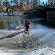
How does Ice on Rivers and Streams Affect USGS Streamflow Data How does Ice on Rivers and Streams Affect USGS Streamflow Data
The USSG computes streamflow several different ways at a streamgage. One very common way is to build a stage-discharge relation that computes a discharge (flow) based on a corresponding stage (elevation of the water-surface). This method relies on a hydraulic feature in the river or stream to control that relationship. The control can be a concrete weir, or natural rock outcrop or riffle.

Major aquifers in New Jersey Major aquifers in New Jersey
Major aquifers in New Jersey consist of regionally extensive areas where the geologic formation or group of formations provide sufficient quantity of groundwater to wells for potable water supply.

Groundwater Response to Earthquakes Groundwater Response to Earthquakes
Did you know? Earthquakes can affect groundwater levels? We often see a response to large (and sometimes not so large) earthquakes in groundwater levels in wells. The USGS maintains a network of wells for monitoring various things like natural variability in water levels and response to pumping and climate change across the U.S.

USGS Data Delivery Tools USGS Data Delivery Tools
The USGS provides access to many different data and analytical tools that are useful for understanding the water-resource data that we collect. These tools allow the public, state and local governments and utilities, and other Federal agencies to view and understand the quality, quantity, distribution, and movement of surface and underground waters in New Jersey.

Geographic Information Systems (GIS) Data for New Jersey Geographic Information Systems (GIS) Data for New Jersey
Spatial/GIS data sets for New Jersey are available numerous spatial data clearinghouses. Spatial/GIS data sets for USGS studies that include New Jersey or include parts of New Jersey are also available from USGS.

Index -Velocity and Hydroacoustics Index -Velocity and Hydroacoustics
Many streams do not have a direct streamflow-to-gage height (water-surface elevation referenced to a datum) relation. These sites include streams influenced by control structures, general backwater effects, and tidal effects. Historically, computation of streamflow at these sites has been difficult. Deploying stationary acoustic doppler instruments allows the USGS to “index” the mean channel veloc

Hydroacoustics and Technological advancements in Streamgaging Hydroacoustics and Technological advancements in Streamgaging
In the mid-1990s, a new technology emerged in the field of streamflow monitoring; the Acoustic Doppler Current Profiler (ADCP). It was originally developed for oceanographic work, but was adapted for inland streamflow measurements. This instrument has been transforming the U.S. Geological Survey (USGS) streamgaging program ever since.

Streamgaging Streamgaging
The U.S. Geological Survey (USGS) established its first streamgage in 1889 on the Rio Grande River at Embudo, NM. As the need for stream-flow information increased, the USGS expanded its Streamgaging network, and continues to do so to this day.

Floods: Recurrence intervals and 100-year floods Floods: Recurrence intervals and 100-year floods
How do we know or measure if a flood that could happen tomorrow is worse than one that happened 2, 10 or 50 years ago? If heavy rain is being forecasted does that mean that rivers are going to rise and spill over their banks and flood your neighborhood? These are some of the questions that we think about when flooding or heavy rain is forecast by public media or the National Weather Service (NWS).