An official website of the United States government
Here's how you know
Official websites use .gov
A .gov website belongs to an official government organization in the United States.
Secure .gov websites use HTTPS
A lock () or https:// means you’ve safely connected to the .gov website. Share sensitive information only on official, secure websites.
Groundwater Exploration in Northwest Kenya, Turkana and Marsabit Counties: Groundwater Potential Mapping, Hydrogeology, Economic Assessment, and Capacity Building
The US Geological Survey collaborated with Northern Arizona University and New Mexico State University in a project funded by the United States Agency for International Development-Kenya and East Africa Mission to investigate the use of satellite image data, along with hydrological and geological data sets, to research and develop maps of the potential of groundwater resources in southern Turkana and Marsabit Counties and to perform an economic assessment of groundwater use. In collaboration with these partners, cutting age technology and a multidisciplinary approach was used to map potential groundwater (PGW), assess its sustainability, and developed an economic optimization scenario modeling to evaluate the potential best use(s) of the water resources given the competing sources of the water resources in the study area and set of measures for the least economic cost to sustain aquifers.
Use of Remote Sensing for Shallow Groundwater Potential
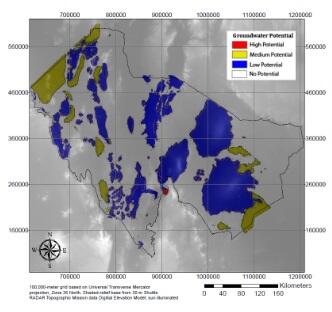
Various remotely-sensed data sets including Landsat, radar, and SRTM, were used to map the PGW to increase resiliency to climate change, promote economic growth and development, improve livelihood, and promote security and stability in the region.
The results were very promising and informative for decisions to be made based on scientific information and help water-related policy debates. The maps below are an example of the outcome of the study showing the potential presences of groundwater and its occurrence categorized as High, Moderate, Low, and No Potential. Potential Infiltration (PI) maps were also generated using radar data.
Maps of combined Potential Groundwater (PGW) and Potential Infiltration (PI) results for southern Turkana (left) and Marsabit (right) Counties
Hydrogeologic Assessment
Once the mapping was completed using remotely sensed, ancillary, and observed data, the hydrogeologic assessment was performed to assess sustainability and to map deeper aquifers in the study area.
The Hydrogeologic Assessment produced five products:
3D volumetric models showing hydrogeologic unit thicknesses and extents,
estimates of aquifer storage from the volumetric models,
The PGW maps and the conceptual hydrogeologic model provide decision makers with decision support tools that can help inform water supply planning and water-related policy with scientifically-based information
Economic Optimization Modelling and Assessment
The results of the optimization modelling indicate the Lodwar and Marsabit pumping regions can be sustainably managed hydrologically and economically. This assessment attempted to increase the extent of reliable aquifer policy choices facing these two regions to better support and inform debates over sustainable aquifer planning. The data used in the model are largely assumed and the results of the model are a “work in progress”. The placeholder data produced a working economic model that can be updated in the future with better quality data by Kenyan water professionals.
Maps of zoomed in areas of western part of southern Turkana along the Turkwel River (left) and the southern part of Marsabit (right) Counties showing Potential Groundwater (PGW) areas.
Capacity Building and Technology Transfer
Capacity building and technology transfer focused on providing formal training in groundwater modeling, groundwater field techniques, and how to obtain and interpret remote sensing data and applications to develop groundwater potential maps. The nature and subject of this training was determined in close consultation with the relevant local agencies. The capacity building and technology transfer was conducted over the life of the study and includes the use of light-weight portable computer system, called the GroundWater Exploration Navigation System (GWENS), to display the PGW maps and in conjunction with a GPS unit, can be used to navigate to locations of potential groundwater.
The next phase of the project will be in the Athi and Tana River Basins in southern Kenya and will start in May 2022
The US Geological Survey collaborated with Northern Arizona University and New Mexico State University in a project funded by the United States Agency for International Development-Kenya and East Africa Mission to investigate the use of satellite image data, along with hydrological and geological data sets, to research and develop maps of the potential of groundwater resources in southern Turkana and Marsabit Counties and to perform an economic assessment of groundwater use. In collaboration with these partners, cutting age technology and a multidisciplinary approach was used to map potential groundwater (PGW), assess its sustainability, and developed an economic optimization scenario modeling to evaluate the potential best use(s) of the water resources given the competing sources of the water resources in the study area and set of measures for the least economic cost to sustain aquifers.
Use of Remote Sensing for Shallow Groundwater Potential
Various remotely-sensed data sets including Landsat, radar, and SRTM, were used to map the PGW to increase resiliency to climate change, promote economic growth and development, improve livelihood, and promote security and stability in the region.
The results were very promising and informative for decisions to be made based on scientific information and help water-related policy debates. The maps below are an example of the outcome of the study showing the potential presences of groundwater and its occurrence categorized as High, Moderate, Low, and No Potential. Potential Infiltration (PI) maps were also generated using radar data.
Maps of combined Potential Groundwater (PGW) and Potential Infiltration (PI) results for southern Turkana (left) and Marsabit (right) Counties
Hydrogeologic Assessment
Once the mapping was completed using remotely sensed, ancillary, and observed data, the hydrogeologic assessment was performed to assess sustainability and to map deeper aquifers in the study area.
The Hydrogeologic Assessment produced five products:
3D volumetric models showing hydrogeologic unit thicknesses and extents,
estimates of aquifer storage from the volumetric models,
The PGW maps and the conceptual hydrogeologic model provide decision makers with decision support tools that can help inform water supply planning and water-related policy with scientifically-based information
Economic Optimization Modelling and Assessment
The results of the optimization modelling indicate the Lodwar and Marsabit pumping regions can be sustainably managed hydrologically and economically. This assessment attempted to increase the extent of reliable aquifer policy choices facing these two regions to better support and inform debates over sustainable aquifer planning. The data used in the model are largely assumed and the results of the model are a “work in progress”. The placeholder data produced a working economic model that can be updated in the future with better quality data by Kenyan water professionals.
Maps of zoomed in areas of western part of southern Turkana along the Turkwel River (left) and the southern part of Marsabit (right) Counties showing Potential Groundwater (PGW) areas.
Capacity Building and Technology Transfer
Capacity building and technology transfer focused on providing formal training in groundwater modeling, groundwater field techniques, and how to obtain and interpret remote sensing data and applications to develop groundwater potential maps. The nature and subject of this training was determined in close consultation with the relevant local agencies. The capacity building and technology transfer was conducted over the life of the study and includes the use of light-weight portable computer system, called the GroundWater Exploration Navigation System (GWENS), to display the PGW maps and in conjunction with a GPS unit, can be used to navigate to locations of potential groundwater.
The next phase of the project will be in the Athi and Tana River Basins in southern Kenya and will start in May 2022