
Saltwater-Interface Mapping - Long Island, New York
Saltwater intrusion is the most common type of water-quality degradation in coastal-plain aquifers. In coastal areas, the hydraulic head under predevelopment (nonpumping) conditions is higher on land than in the surrounding saltwater embayments; thus, fresh groundwater flows seaward (from areas of high potential to areas of lower potential) and meets saltwater at an equilibrium point (interface) offshore. If the natural hydraulic gradient is reversed by pumping, however, fresh groundwater flows toward the pumping well instead of seaward toward the interface, thus, the interface moves landward and saltwater intrusion occurs.
Characteristics of Saltwater Intrusion

Seawater has an average chloride concentration of 19,350 mg/L (Drever, 1988). A grab sample taken in 1996 from the nearshore area of Long Island Sound, near Great Neck, had a chloride concentration of 13,995 mg/L; this indicated some freshwater inflow into Long Island Sound (Stumm, 2001) from the aquifer. The predevelopment concentration of chloride in fresh groundwater on Long Island was 10 mg/L or less (Lusczynski and Swarzenski, 1966), and shallow (upper glacial aquifer) groundwater in urbanized areas of Long Island generally has an ambient chloride concentration of less than 40 mg/L (Buxton and others, 1981; Heisig and Prince, 1993); with this increase since the predevelopment period being attributed to contamination from land-surface sources.
Ambient water for Long Island can be defined as groundwater with a chloride concentration of less than 40 mg/L; “brackish” water as groundwater with a chloride concentration of 40 to 250 mg/L; and “saltwater” as groundwater with a chloride concentration greater than 250 mg/L (Lusczynski and Swarzenski, 1966; Chu and Stumm, 1995; Stumm, 2001; Stumm and others, 2002).
Historic chloride concentrations at production wells, and in samples from inland observation wells on Long Island, indicate that the background chloride concentration in the Lloyd and North Shore aquifers is 5 to 10 mg/L. Any increase in chloride concentrations above these predevelopment levels in the Lloyd and North Shore aquifers on Long Island would be indicative of saltwater intrusion from the surrounding saltwater embayments in response to pumping stresses.
The USGS has delineated active saltwater intrusion at a number of locations across Long Island (fig. 1), including in areas of Northern Nassau County where an analysis of 50 years of chloride-concentration and pumpage data from production wells on the Great Neck Peninsula indicates that once a concentration of 50 mg/L is exceeded at a production well screened in the Lloyd aquifer, the concentrations will remain above 50 mg/L even if pumping is decreased (Stumm, 2001). The process of pumping only in alternate years at production wells with elevated chloride concentrations only slightly delays an inevitable rapid increase in chloride concentrations. This is because once the toe, or leading edge, of the saltwater wedge reaches the production well, it is “up coned” into the screen zone of the well and responds to decreased pumping for only a short time before stabilizing into a rapid, continuous increase.
Recent drilling in southern Kings, Queens, and Kings Counties on Long Island indicate both the Lloyd and Magothy aquifers are intruded with saltwater (fig. 1). Historical analyses of chloride concentrations from observation wells indicate the position of the saltwater-freshwater interface was along the southern coast of Kings and Queens Counties during predevelopment (Stumm and others, 2024).

Approach
As new observation wells are drilled and installed for this study, filter press samples are collected, the wells are sampled for water quality, and borehole geophysical logs are collected. Surface geophysical methods, such as time domain electromagnetic (TDEM) method are also being utilized to fill in gaps between wells, and to help direct future well locations in preparation for drilling programs.
Filter Press Sampling
Filter-press samples for chloride and specific-conductance measurements are being collected by the USGS from selected sediment-core samples obtained during the drilling process at newly installed observation wells. The filter-press sample is collected using nitrogen-gas pressure to force interstitial water from parts of a split-spoon sediment-core sample not contaminated by drilling mud (Lusczynski, 1961). The chloride concentration and specific conductance of the extracted water is measured by calibrated hand-held probes. The resulting values are used as a general indicator of brackish or salty water within a formation, and is being correlated with borehole-geophysical logs and the values from water samples collected from the PVC cased and screened wells.
Water Quality Sampling (Chloride Concentrations)
Water samples are being collected by the USGS from newly installed and select existing observation wells, and being analyzed by the USGS National Water Quality Laboratory in Denver, CO. Analyses includes determining the concentration of chloride and other inorganic constituents. Under natural conditions chloride values in the Lloyd (and North Shore) aquifers on Long Island are less than 5 mg/L. Due to saltwater intrusion, chloride concentrations can increase significantly depending on the location of a well with respect to the saltwater interface. Volatile Organic Compounds (VOCs) and other potential contaminants will not be analyzed as they are beyond the scope of this project.
Borehole Geophysics
While analysis of water-quality samples collected from a well provide highly accurate chloride concentrations, they only reflect the water chemistry from the screen zone, which is generally less than 2% of the entire aquifer thickness. Through the use of borehole-geophysical techniques (single-point resistance, resistivity, and EM-conductivity) the thickness of the saltwater wedge can be measured, and chloride concentrations estimated using a modeled equation for the entire aquifer. With PVC cased wells, EM-conductivity logs can be collected periodically to effectively monitor small changes in the thickness and concentration of saltwater intrusion.
Surface Geophysics (TDEM)
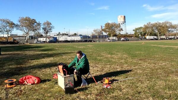
The time domain electromagnetic (TDEM) method is a surface-geophysical technique that uses a transmitter loop and receiver coil placed on the land surface, from which an electrical current is passed through the transmitter loop creating an electromagnetic field (fig. 2). This field is switched on and off, which induces eddy currents in the subsurface producing a secondary electromagnetic field. The decay of this secondary electromagnetic field is then measured by the receiver coil. The amplitude of the current starts to decay immediately, which induces more current to flow, but now at a greater depth from the transmitter loop. The deeper current flow also decays, which then induces even deeper currents to flow. Data are collected at the receiver coil, with progressively later times representing the electrical properties of the deeper layers in the subsurface. These data are then processed and inverted to produce a one dimensional resistivity curve. As part of this study TDEM surveys were collected by the USGS at many locations across Long Island (fig. 3).

Saltwater intrusion is the most common type of water-quality degradation in coastal-plain aquifers. In coastal areas, the hydraulic head under predevelopment (nonpumping) conditions is higher on land than in the surrounding saltwater embayments; thus, fresh groundwater flows seaward (from areas of high potential to areas of lower potential) and meets saltwater at an equilibrium point (interface) offshore. If the natural hydraulic gradient is reversed by pumping, however, fresh groundwater flows toward the pumping well instead of seaward toward the interface, thus, the interface moves landward and saltwater intrusion occurs.
Characteristics of Saltwater Intrusion
Seawater has an average chloride concentration of 19,350 mg/L (Drever, 1988). A grab sample taken in 1996 from the nearshore area of Long Island Sound, near Great Neck, had a chloride concentration of 13,995 mg/L; this indicated some freshwater inflow into Long Island Sound (Stumm, 2001) from the aquifer. The predevelopment concentration of chloride in fresh groundwater on Long Island was 10 mg/L or less (Lusczynski and Swarzenski, 1966), and shallow (upper glacial aquifer) groundwater in urbanized areas of Long Island generally has an ambient chloride concentration of less than 40 mg/L (Buxton and others, 1981; Heisig and Prince, 1993); with this increase since the predevelopment period being attributed to contamination from land-surface sources.
Ambient water for Long Island can be defined as groundwater with a chloride concentration of less than 40 mg/L; “brackish” water as groundwater with a chloride concentration of 40 to 250 mg/L; and “saltwater” as groundwater with a chloride concentration greater than 250 mg/L (Lusczynski and Swarzenski, 1966; Chu and Stumm, 1995; Stumm, 2001; Stumm and others, 2002).
Historic chloride concentrations at production wells, and in samples from inland observation wells on Long Island, indicate that the background chloride concentration in the Lloyd and North Shore aquifers is 5 to 10 mg/L. Any increase in chloride concentrations above these predevelopment levels in the Lloyd and North Shore aquifers on Long Island would be indicative of saltwater intrusion from the surrounding saltwater embayments in response to pumping stresses.
The USGS has delineated active saltwater intrusion at a number of locations across Long Island (fig. 1), including in areas of Northern Nassau County where an analysis of 50 years of chloride-concentration and pumpage data from production wells on the Great Neck Peninsula indicates that once a concentration of 50 mg/L is exceeded at a production well screened in the Lloyd aquifer, the concentrations will remain above 50 mg/L even if pumping is decreased (Stumm, 2001). The process of pumping only in alternate years at production wells with elevated chloride concentrations only slightly delays an inevitable rapid increase in chloride concentrations. This is because once the toe, or leading edge, of the saltwater wedge reaches the production well, it is “up coned” into the screen zone of the well and responds to decreased pumping for only a short time before stabilizing into a rapid, continuous increase.
Recent drilling in southern Kings, Queens, and Kings Counties on Long Island indicate both the Lloyd and Magothy aquifers are intruded with saltwater (fig. 1). Historical analyses of chloride concentrations from observation wells indicate the position of the saltwater-freshwater interface was along the southern coast of Kings and Queens Counties during predevelopment (Stumm and others, 2024).
Approach
As new observation wells are drilled and installed for this study, filter press samples are collected, the wells are sampled for water quality, and borehole geophysical logs are collected. Surface geophysical methods, such as time domain electromagnetic (TDEM) method are also being utilized to fill in gaps between wells, and to help direct future well locations in preparation for drilling programs.
Filter Press Sampling
Filter-press samples for chloride and specific-conductance measurements are being collected by the USGS from selected sediment-core samples obtained during the drilling process at newly installed observation wells. The filter-press sample is collected using nitrogen-gas pressure to force interstitial water from parts of a split-spoon sediment-core sample not contaminated by drilling mud (Lusczynski, 1961). The chloride concentration and specific conductance of the extracted water is measured by calibrated hand-held probes. The resulting values are used as a general indicator of brackish or salty water within a formation, and is being correlated with borehole-geophysical logs and the values from water samples collected from the PVC cased and screened wells.
Water Quality Sampling (Chloride Concentrations)
Water samples are being collected by the USGS from newly installed and select existing observation wells, and being analyzed by the USGS National Water Quality Laboratory in Denver, CO. Analyses includes determining the concentration of chloride and other inorganic constituents. Under natural conditions chloride values in the Lloyd (and North Shore) aquifers on Long Island are less than 5 mg/L. Due to saltwater intrusion, chloride concentrations can increase significantly depending on the location of a well with respect to the saltwater interface. Volatile Organic Compounds (VOCs) and other potential contaminants will not be analyzed as they are beyond the scope of this project.
Borehole Geophysics
While analysis of water-quality samples collected from a well provide highly accurate chloride concentrations, they only reflect the water chemistry from the screen zone, which is generally less than 2% of the entire aquifer thickness. Through the use of borehole-geophysical techniques (single-point resistance, resistivity, and EM-conductivity) the thickness of the saltwater wedge can be measured, and chloride concentrations estimated using a modeled equation for the entire aquifer. With PVC cased wells, EM-conductivity logs can be collected periodically to effectively monitor small changes in the thickness and concentration of saltwater intrusion.
Surface Geophysics (TDEM)
The time domain electromagnetic (TDEM) method is a surface-geophysical technique that uses a transmitter loop and receiver coil placed on the land surface, from which an electrical current is passed through the transmitter loop creating an electromagnetic field (fig. 2). This field is switched on and off, which induces eddy currents in the subsurface producing a secondary electromagnetic field. The decay of this secondary electromagnetic field is then measured by the receiver coil. The amplitude of the current starts to decay immediately, which induces more current to flow, but now at a greater depth from the transmitter loop. The deeper current flow also decays, which then induces even deeper currents to flow. Data are collected at the receiver coil, with progressively later times representing the electrical properties of the deeper layers in the subsurface. These data are then processed and inverted to produce a one dimensional resistivity curve. As part of this study TDEM surveys were collected by the USGS at many locations across Long Island (fig. 3).