
Flooding after the winter storm of January 12th, 2024, in Wading River along Creek Road and Sound Road.
Frederick Stumm
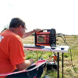
My projects have involved the application of hydrology, geology, and geophysics to environmental and engineering problems. They include delineating the extent of saltwater intrusion in coastal aquifers, mapping roadsalt plumes, detecting bridge scour, mapping hydrogeologic frameworks, delineating the fractured-rock groundwater system in Manhattan, and mapping depth to bedro
I hold a B.S. in Geology from Hofstra University, a M.S.. in Geology from California State University Fresno, and a Ph.D. in Earth and Environmental Science from the City University of New York Graduate Center. I take a multi-disciplinary approach applying Hydrology, Geology, and Geophysics with a focus on understanding the extent and mechanisms for saltwater intrusion on Long Island, the deposition of complex hydrogeologic frameworks, and quantifying fractured-rock groundwater flow. I recieved the Distinguished Scientific Achievement Award from the New York Federal Executive Board for my work on delineating the fractures, faults, foliation, and groundwater flow in Manhattan's bedrock using advanced borehole geophysical methods in support of the New York City Water Tunnel #3 Project. I have worked for the New York Water Science Center for over 20 years on studies that have helped coastal communities manage their water resources by delineating the extent of saltwater intrusion, improve construction safety and reduce cost overruns during construction of New York City Water Tunnel #3, the new Croton Water Filtration Tunnel, and the leakage in the Rondout West Branch Water Tunnel in Wawarsing NY, map the depth to bedrock in NYC, and delineated the extent of bridge scour at the Sloop Channel Bridge that lead to it's replacement. My ongoing projects include the delineation of the fractured-rock flow system in Wawarsing in support of the planned tunnel leakage repairs, the creation of the highest resolution bedrock maps for NYC in support of it's geothermal energy program, delineation of the saltwater-freshwater interface on Shelter Island NY, and remapping the hydrogeologic framework and delineation of saltwater intrusion throughout Long Island. My current research involves the application of radio signals transmitted between two wells to create two and three dimensional images of conductivity which can be used to map conductive plumes and possibly voids in bedrock.
Science and Products

Groundwater Sustainability of the Long Island Aquifer System
The U.S. Geological Survey (USGS) has partnered with the New York State Department of Environmental Conservation (NYSDEC) to conduct a comprehensive study of the Long Island aquifer system. The major findings of this investigation include: The location of the boundary between fresh and salty groundwater is much closer to the shoreline than previously thought. The historical onshore saltwater...
Hydrogeologic-Framework Mapping - Long Island, New York
Long Island is underlain by unconsolidated Holocene deposits, glacial deposits of Pleistocene age, and coastal-plain deposits of Late Cretaceous age. These sediments consist of gravel, sand, silt, and clay underlain by crystalline bedrock of early Paleozoic age (figure 2b). The bedrock is relatively impermeable, and forms the base of the groundwater-flow system on Long Island. The geologic and...
Saltwater-Interface Mapping - Long Island, New York
Saltwater intrusion is the most common type of water-quality degradation in coastal-plain aquifers. In coastal areas, the hydraulic head under predevelopment (nonpumping) conditions is higher on land than in the surrounding saltwater embayments; thus, fresh groundwater flows seaward (from areas of high potential to areas of lower potential) and meets saltwater at an equilibrium point (interface)...

Delineation of the Saltwater-Freshwater Interface at Selected Well Locations in the Town of Riverhead, NY
Problem The Town of Riverhead in the northeastern Suffolk County includes rural farmland and suburbs and is bounded by the Long Island Sound to the north and Peconic Bay to the southeast. Riverhead’s close proximity to saline embayments and its location along the northeastern discharge area for Long Island’s groundwater flow system makes it vulnerable to saltwater intrusion. Several...

Hydrogeology and Water Quality of the North Shore Aquifer in Locust Valley, Town of Oyster Bay, New York
Problem Perchlorate detected in a shallow supply well within the southern portion of the Locust Valley Water District (LVWD) has prompted interest in determining the possible existence of a deeper confined aquifer (North Shore Aquifer) that may be protected from shallow contamination (fig. 1). Previous USGS studies in this area indicate the northern part of Nassau County has a complex

Delineation of the Freshwater-Saltwater Interface at Selected Public-Supply Wells Using Advanced Surface and Borehole Geophysical Techniques, in Eastern Suffolk County, New York
The combination of a complex hydrogeologic framework, narrow land masses surrounded by saltwater, and extensive ground-water public-supply pumpage has produced localized areas of elevated chloride concentrations in ground water. This project uses advanced surface and borehole geophysical methods to determine the extent of saltwater intrusion and road-salt plumes at selected sites in...

Delineation of Groundwater Flow, Lithology, Faults, and Fractures Along Existing and Proposed Water Tunnel
Problem The New York City Department of Environmental Protection (NYCDEP) has asked the U.S. Geological Survey (USGS) to assist in two major studies: 1) delineation of the source(s) of shallow groundwater and the extent that the Delaware Aqueduct is contributing to local flooding issues, and 2) delineation of the structural, geologic, and hydrologic conditions along proposed tunnel...

Delineation of Rock Fractures, Faults, and Groundwater Flow in the Vicinity of Proposed Water Tunnels, New York City and Southeastern New York
Problem - The New York City Department of Environmental Protection (NYCDEP) is constructing or proposing water tunnels under New York City and areas of southeastern New York (Hudson River Basin). These tunnels can intersect faults and fractures that produce large amounts of ground water. For example, one tunnel excavation intersected fractures that produced over 200 gallons per minute of
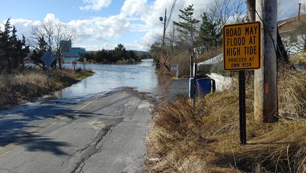
Wading River Flooding
Flooding after the winter storm of January 12th, 2024, in Wading River along Creek Road and Sound Road.
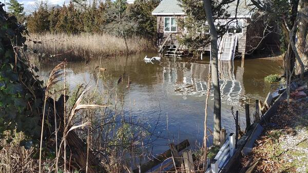
Wading River flooding after a massive winter storm
Wading River flooding after a massive winter stormFlooded front yard of a house near the Wading River after a massive winter storm in January 2024.
Wading River flooding after a massive winter storm
Wading River flooding after a massive winter stormFlooded front yard of a house near the Wading River after a massive winter storm in January 2024.
Science and Products
Groundwater Sustainability of the Long Island Aquifer System
The U.S. Geological Survey (USGS) has partnered with the New York State Department of Environmental Conservation (NYSDEC) to conduct a comprehensive study of the Long Island aquifer system. The major findings of this investigation include: The location of the boundary between fresh and salty groundwater is much closer to the shoreline than previously thought. The historical onshore saltwater...
Hydrogeologic-Framework Mapping - Long Island, New York
Long Island is underlain by unconsolidated Holocene deposits, glacial deposits of Pleistocene age, and coastal-plain deposits of Late Cretaceous age. These sediments consist of gravel, sand, silt, and clay underlain by crystalline bedrock of early Paleozoic age (figure 2b). The bedrock is relatively impermeable, and forms the base of the groundwater-flow system on Long Island. The geologic and...
Saltwater-Interface Mapping - Long Island, New York
Saltwater intrusion is the most common type of water-quality degradation in coastal-plain aquifers. In coastal areas, the hydraulic head under predevelopment (nonpumping) conditions is higher on land than in the surrounding saltwater embayments; thus, fresh groundwater flows seaward (from areas of high potential to areas of lower potential) and meets saltwater at an equilibrium point (interface)...
Delineation of the Saltwater-Freshwater Interface at Selected Well Locations in the Town of Riverhead, NY
Problem The Town of Riverhead in the northeastern Suffolk County includes rural farmland and suburbs and is bounded by the Long Island Sound to the north and Peconic Bay to the southeast. Riverhead’s close proximity to saline embayments and its location along the northeastern discharge area for Long Island’s groundwater flow system makes it vulnerable to saltwater intrusion. Several...
Hydrogeology and Water Quality of the North Shore Aquifer in Locust Valley, Town of Oyster Bay, New York
Problem Perchlorate detected in a shallow supply well within the southern portion of the Locust Valley Water District (LVWD) has prompted interest in determining the possible existence of a deeper confined aquifer (North Shore Aquifer) that may be protected from shallow contamination (fig. 1). Previous USGS studies in this area indicate the northern part of Nassau County has a complex
Delineation of the Freshwater-Saltwater Interface at Selected Public-Supply Wells Using Advanced Surface and Borehole Geophysical Techniques, in Eastern Suffolk County, New York
The combination of a complex hydrogeologic framework, narrow land masses surrounded by saltwater, and extensive ground-water public-supply pumpage has produced localized areas of elevated chloride concentrations in ground water. This project uses advanced surface and borehole geophysical methods to determine the extent of saltwater intrusion and road-salt plumes at selected sites in...
Delineation of Groundwater Flow, Lithology, Faults, and Fractures Along Existing and Proposed Water Tunnel
Problem The New York City Department of Environmental Protection (NYCDEP) has asked the U.S. Geological Survey (USGS) to assist in two major studies: 1) delineation of the source(s) of shallow groundwater and the extent that the Delaware Aqueduct is contributing to local flooding issues, and 2) delineation of the structural, geologic, and hydrologic conditions along proposed tunnel...
Delineation of Rock Fractures, Faults, and Groundwater Flow in the Vicinity of Proposed Water Tunnels, New York City and Southeastern New York
Problem - The New York City Department of Environmental Protection (NYCDEP) is constructing or proposing water tunnels under New York City and areas of southeastern New York (Hudson River Basin). These tunnels can intersect faults and fractures that produce large amounts of ground water. For example, one tunnel excavation intersected fractures that produced over 200 gallons per minute of
Wading River Flooding
Flooding after the winter storm of January 12th, 2024, in Wading River along Creek Road and Sound Road.
Flooding after the winter storm of January 12th, 2024, in Wading River along Creek Road and Sound Road.
Wading River flooding after a massive winter storm
Wading River flooding after a massive winter stormFlooded front yard of a house near the Wading River after a massive winter storm in January 2024.
Wading River flooding after a massive winter storm
Wading River flooding after a massive winter stormFlooded front yard of a house near the Wading River after a massive winter storm in January 2024.