
Title: Snow and Avalanche Science - Highlights of applied avalanche research and forecasting
Going-to-the-Sun Road Avalanche Forecasting Program
Active
By Northern Rocky Mountain Science Center
July 25, 2025
As the most popular attraction in Glacier National Park, Going-to-the-Sun Road (GTSR) traverses scenic alpine zones and crosses the Continental Divide. The Park closes a section of GTSR each winter due to inclement weather, heavy snowfall, and avalanche hazards. Annual spring opening of GTSR is a highly anticipated event for visitors, and the regional economy is strongly tied to the road’s accessibility. Since 2003, efforts to open the road each spring rely on a USGS-National Parks Service partnership based on the expertise of USGS avalanche scientists, who provide on-site avalanche forecasting. The applied research from ongoing USGS avalanche studies supports forecasting efforts that guide the safety of this hazardous road opening operation each year.
Media

Sources/Usage: Public Domain. View Media Details
Going-to-the-Sun Road
Going-to-the-Sun Road (GTSR) is a premier attraction of Glacier National Park, Montana. The 50-mile, two-lane road crosses the Continental Divide at its highest elevation—Logan Pass (6,647' or 2,026 m) and offers visitors many attractions along its length.
The Park closes a 34.8-mile (56 km) section of GTSR each winter due to dangerous weather conditions, heavy snow, and avalanche hazards. With its many attractions, the opening of the GTSR in the spring starts Glacier National Park’s, and by extension, the region’s tourist seasons.
- Glacier National Park is an economic driver in the region—in 2023, the park:
- hosted 2.9 million visitors
- supported about 5,700 jobs
- generated an economic footprint in the Region of about \$555 million
- Clearing the road of snow during spring road clearing occurs from April to May or June and can be dangerous because it occurs during avalanche season
- There is a need to open GTSR as soon as it is feasible and as safely as possible and USGS expertise helps make that happen
Media
Sources/Usage: Public Domain. View Media Details
USGS-National Park Service Avalanche Forecasting Program
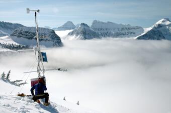
In the 2003 season, the USGS, in partnership with the National Park Service (NPS), established a daily avalanche forecasting program in Glacier National Park with two full time avalanche specialists—one from the NPS and one from the USGS Northern Rocky Mountain Science Center (NOROCK). For most of the 71 years prior to that, the park relied on road crew foremen who had little to no avalanche training to make decisions on when to work in avalanche zones during spring road clearing. In 2021, the NPS also requested USGS assistance to provide avalanche information for NPS Visitor Resource Protection division decision-making on when to keep certain sections of the road open or closed to visitors due to avalanche hazard thus making USGS avalanche forecasting a 7-day/week operation. Now, three USGS avalanche forecasters provide avalanche hazard products for both public and worker safety.
- Some resources were in already place that the new avalanche researchers could use while other resources needed to be acquired
- The Flattop SNOTEL weather station and one USGS weather station at Logan Pass were already in place and collectively provided, precipitation, temperature, relative humidity, wind, and solar data needed for accurate avalanche forecasting
- Neither weather station was established for avalanche forecasting, but the data were somewhat useful for those ends. However, the researchers learned they needed a weather station that could better assist them with predicting the most common general type of avalanche that threatened GTSR, wet avalanches, which contains some liquid water within the snowpack. This can be a common occurrence during warmer spring days.
- The Garden Wall weather station was installed in December 2003 to help better predict all types of avalanches given the proximity to the avalanche path starting zones. This station is located next to the largest avalanche path (Haystack Creek avalanche path) that threatens GTSR.
- NOROCK avalanche experts provide daily avalanche forecasts during the spring GTSR clearing to ensure NPS personnel and the public are kept safe and to make the road clearing efficient
- The avalanche experts also monitor changing snow conditions when road crews are in avalanche zones for an additional layer of safety
Going to the Sun Road Avalanche Story Map
Going to the Sun Road Avalanche Story Map
Glacier National Park plowing status
Glacier National Park plowing status
Avalanche forecasts: Flathead National Forest & Glacier National Park
Avalanche forecasts: Flathead National Forest & Glacier National Park
Forecasting avalanches in Glacier National Park—Paper
Forecasting avalanches in Glacier National Park—Paper
Below are other science projects associated with this project.

Science in Glacier National Park
Glacier National Park (GNP) is considered a stronghold for a large diversity of plant and animal species and harbors some of the last remaining populations of threatened and endangered species such as grizzly bear and bull trout, as well as non threatened, yet ecologically important species such as bighorn sheep and black bear. The mountain ecosystems of GNP that support these species are dynamic...
Below are multimedia items associated with this project.

PubTalk 3/2018 - Snow & Avalanche Science
Title: Snow and Avalanche Science - Highlights of applied avalanche research and forecasting
As the most popular attraction in Glacier National Park, Going-to-the-Sun Road (GTSR) traverses scenic alpine zones and crosses the Continental Divide. The Park closes a section of GTSR each winter due to inclement weather, heavy snowfall, and avalanche hazards. Annual spring opening of GTSR is a highly anticipated event for visitors, and the regional economy is strongly tied to the road’s accessibility. Since 2003, efforts to open the road each spring rely on a USGS-National Parks Service partnership based on the expertise of USGS avalanche scientists, who provide on-site avalanche forecasting. The applied research from ongoing USGS avalanche studies supports forecasting efforts that guide the safety of this hazardous road opening operation each year.
Media
Sources/Usage: Public Domain. View Media Details
Going-to-the-Sun Road
Going-to-the-Sun Road (GTSR) is a premier attraction of Glacier National Park, Montana. The 50-mile, two-lane road crosses the Continental Divide at its highest elevation—Logan Pass (6,647' or 2,026 m) and offers visitors many attractions along its length.
The Park closes a 34.8-mile (56 km) section of GTSR each winter due to dangerous weather conditions, heavy snow, and avalanche hazards. With its many attractions, the opening of the GTSR in the spring starts Glacier National Park’s, and by extension, the region’s tourist seasons.
- Glacier National Park is an economic driver in the region—in 2023, the park:
- hosted 2.9 million visitors
- supported about 5,700 jobs
- generated an economic footprint in the Region of about \$555 million
- Clearing the road of snow during spring road clearing occurs from April to May or June and can be dangerous because it occurs during avalanche season
- There is a need to open GTSR as soon as it is feasible and as safely as possible and USGS expertise helps make that happen
Media
Sources/Usage: Public Domain. View Media Details
USGS-National Park Service Avalanche Forecasting Program
In the 2003 season, the USGS, in partnership with the National Park Service (NPS), established a daily avalanche forecasting program in Glacier National Park with two full time avalanche specialists—one from the NPS and one from the USGS Northern Rocky Mountain Science Center (NOROCK). For most of the 71 years prior to that, the park relied on road crew foremen who had little to no avalanche training to make decisions on when to work in avalanche zones during spring road clearing. In 2021, the NPS also requested USGS assistance to provide avalanche information for NPS Visitor Resource Protection division decision-making on when to keep certain sections of the road open or closed to visitors due to avalanche hazard thus making USGS avalanche forecasting a 7-day/week operation. Now, three USGS avalanche forecasters provide avalanche hazard products for both public and worker safety.
- Some resources were in already place that the new avalanche researchers could use while other resources needed to be acquired
- The Flattop SNOTEL weather station and one USGS weather station at Logan Pass were already in place and collectively provided, precipitation, temperature, relative humidity, wind, and solar data needed for accurate avalanche forecasting
- Neither weather station was established for avalanche forecasting, but the data were somewhat useful for those ends. However, the researchers learned they needed a weather station that could better assist them with predicting the most common general type of avalanche that threatened GTSR, wet avalanches, which contains some liquid water within the snowpack. This can be a common occurrence during warmer spring days.
- The Garden Wall weather station was installed in December 2003 to help better predict all types of avalanches given the proximity to the avalanche path starting zones. This station is located next to the largest avalanche path (Haystack Creek avalanche path) that threatens GTSR.
- NOROCK avalanche experts provide daily avalanche forecasts during the spring GTSR clearing to ensure NPS personnel and the public are kept safe and to make the road clearing efficient
- The avalanche experts also monitor changing snow conditions when road crews are in avalanche zones for an additional layer of safety
Going to the Sun Road Avalanche Story Map
Going to the Sun Road Avalanche Story Map
Glacier National Park plowing status
Glacier National Park plowing status
Avalanche forecasts: Flathead National Forest & Glacier National Park
Avalanche forecasts: Flathead National Forest & Glacier National Park
Forecasting avalanches in Glacier National Park—Paper
Forecasting avalanches in Glacier National Park—Paper
Below are other science projects associated with this project.
Science in Glacier National Park
Glacier National Park (GNP) is considered a stronghold for a large diversity of plant and animal species and harbors some of the last remaining populations of threatened and endangered species such as grizzly bear and bull trout, as well as non threatened, yet ecologically important species such as bighorn sheep and black bear. The mountain ecosystems of GNP that support these species are dynamic...
Below are multimedia items associated with this project.
PubTalk 3/2018 - Snow & Avalanche Science
Title: Snow and Avalanche Science - Highlights of applied avalanche research and forecasting
Title: Snow and Avalanche Science - Highlights of applied avalanche research and forecasting