
Sumner Dam Outfall. Pecos River Watershed Salinity Study. 2014 field trip, New Mexico.
Images
Photographs taken by Oklahoma-Texas Water Science Center employees at local, national, and international project locations.
Filter Total Items: 551
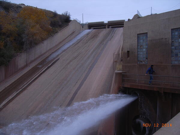
Sumner Dam Outfall
Sumner Dam Outfall. Pecos River Watershed Salinity Study. 2014 field trip, New Mexico.
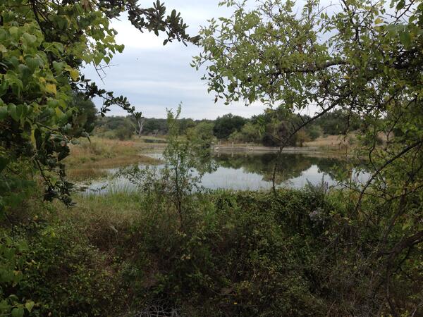
Clear Cr nr Menard
Clear Cr nr Menard

Equipment at Trinity River at Dallas
Bridge-mounted stream monitoring equipment at USGS 08057000, Trinity River at Dallas
Bridge-mounted stream monitoring equipment at USGS 08057000, Trinity River at Dallas

Oklahoma windmill at sunset
Oklahoma windmill at sunset

Salt Fork Red River along HWY 6
Salt Fork Red River along HWY 6

Salt Fork of the Red River off HWY 6
Salt Fork of the Red River off HWY 6

Previously active volcano site in Texas
A site where volcanoes used to be active in the Chinati Mountains near Presidio, Texas.
A site where volcanoes used to be active in the Chinati Mountains near Presidio, Texas.

Crest-stage gage 07307550 Wind River tributary
U.S. Geological Survey crest-stage gage 07307550 Wind River tributary at Farm to Market 656 near Northfield, Texas, looking downstream, May 24, 2014 (photograph by W.H. Asquith).
Cover photograph for U.S. Geological Survey Scientific Investigations Report 2018–5107
U.S. Geological Survey crest-stage gage 07307550 Wind River tributary at Farm to Market 656 near Northfield, Texas, looking downstream, May 24, 2014 (photograph by W.H. Asquith).
Cover photograph for U.S. Geological Survey Scientific Investigations Report 2018–5107

West Fork Trinity at Fort Worth
Culvert at USGS 08048000 West Fork Trinity River at Fort Worth, TX
Culvert at USGS 08048000 West Fork Trinity River at Fort Worth, TX

Trinity River below Dallas
View from bridge at USGS station 08057410, Trinity River below Dallas
View from bridge at USGS station 08057410, Trinity River below Dallas

USGS scientist measuring flow downstream of Comal Springs
USGS scientist measuring flow downstream of Comal SpringsUSGS scientist Vidal Mendoza measures flow downstream of the Comal Springs, Texas.
A new website now provides important information about streamflow in the Comal and San Marcos Rivers and springflow at Comal and San Marcos Springs.

A USGS streamflow gauge station in the lower Trinity River, Texas.
A USGS streamflow gauge station in the lower Trinity River, Texas.A USGS streamflow gauge station in the lower Trinity River, Texas.
A USGS streamflow gauge station in the lower Trinity River, Texas.
A USGS streamflow gauge station in the lower Trinity River, Texas.A USGS streamflow gauge station in the lower Trinity River, Texas.

USGS scientist collecting time-domain electromagnetic sounding
USGS scientist collecting time-domain electromagnetic soundingUSGS scientist Jon Thomas collecting time-domain electromagnetic sounding in the Texas southern high plains to measure hydrogeologic properties below the land surface.
USGS scientist collecting time-domain electromagnetic sounding
USGS scientist collecting time-domain electromagnetic soundingUSGS scientist Jon Thomas collecting time-domain electromagnetic sounding in the Texas southern high plains to measure hydrogeologic properties below the land surface.

USGS scientists collect time-domain electromagnetic sounding
USGS scientists collect time-domain electromagnetic soundingUSGS scientists collect time-domain electromagnetic sounding in the Texas southern highplains to measure hydrogeologic properties below the land surface.
USGS scientists collect time-domain electromagnetic sounding
USGS scientists collect time-domain electromagnetic soundingUSGS scientists collect time-domain electromagnetic sounding in the Texas southern highplains to measure hydrogeologic properties below the land surface.

Panoramic view of a chat pile on the St. Joe property, Picher, Oklahom
Panoramic view of a chat pile on the St. Joe property, Picher, OklahomPanoramic view of a chat pile on the St. Joe property, Picher, Oklahoma, looking east.
Panoramic view of a chat pile on the St. Joe property, Picher, Oklahom
Panoramic view of a chat pile on the St. Joe property, Picher, OklahomPanoramic view of a chat pile on the St. Joe property, Picher, Oklahoma, looking east.

Drilling near Hominy Creek in the Osage Nation, OK
Drilling near Hominy Creek in the Osage Nation, OKDrilling near Hominy Creek in the Osage Nation, OK.
Drilling near Hominy Creek in the Osage Nation, OK
Drilling near Hominy Creek in the Osage Nation, OKDrilling near Hominy Creek in the Osage Nation, OK.

Sand Creek in Osage County, OK
Sand Creek in Osage County, OK

Upstream view of 2013 flooding at N. Canadian River at Britton Rd
Upstream view of 2013 flooding at N. Canadian River at Britton RdUpstream view of the 2013 flooding from the bridge at USGS site 07241520, North Canadian River at Britton Rd at Oklahoma City, OK
Upstream view of 2013 flooding at N. Canadian River at Britton Rd
Upstream view of 2013 flooding at N. Canadian River at Britton RdUpstream view of the 2013 flooding from the bridge at USGS site 07241520, North Canadian River at Britton Rd at Oklahoma City, OK

Downstream view of 2013 flooding at N. Canadian River at Britton Rd
Downstream view of 2013 flooding at N. Canadian River at Britton RdDownstream view of 2013 flooding from the bridge at USGS site 07241520, North Canadian River at Britton Rd at Oklahoma City, OK
Downstream view of 2013 flooding at N. Canadian River at Britton Rd
Downstream view of 2013 flooding at N. Canadian River at Britton RdDownstream view of 2013 flooding from the bridge at USGS site 07241520, North Canadian River at Britton Rd at Oklahoma City, OK

2013 Flooding of North Canadian River at Harrah
View from bridge of the 2013 Flooding at USGS 07241550, North Canadian River at Harrah, OK
View from bridge of the 2013 Flooding at USGS 07241550, North Canadian River at Harrah, OK

Collecting suspended-sediment sample, Cibolo Ck., Tex.
Collecting suspended-sediment sample, Cibolo Ck., Tex.Collection of a suspended-sediment sample by hydrologic technicians at U.S. Geological Survey station 08185000 Cibolo Creek at Selma, Texas, on May 25, 2013.
Collecting suspended-sediment sample, Cibolo Ck., Tex.
Collecting suspended-sediment sample, Cibolo Ck., Tex.Collection of a suspended-sediment sample by hydrologic technicians at U.S. Geological Survey station 08185000 Cibolo Creek at Selma, Texas, on May 25, 2013.