
GeoPulse boomer plates are used with a high-resolution seismic system
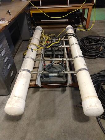
The boomer plate produces a repeatable pulse in the 1-6kHz frequency range using an electrodynamic transducer that can be powered by a capacitor discharge system. It has a penetration on the order of 150 m (depending on sediment type) and provides a balance between resolution and penetration. It can be used in freshwater lakes where a sparker would not be suitable.
Specifications
- Manufacturer: F.O.R.E.
- Model: 5813A GeoPulse Acoustic Source
- Weight:
- Dimensions:
- Power Requirements: CSP or CSP-D Power Supply, Max Power Input 360 Joules @ 2 pps (720 W)
Operational Characteristics
- Minimum Operational Depth: 1m
- Maximum Operational Depth: 500 m
- Sediment Type: Any
- Limitations:
- Power Outputs / Freq. Ranges: 1- 6 kHz, peak source levels more than 210 dB re 1 micro Pascal at 1 m
- Ship’s Requirements
- A-frame, davit, j-frame etc. or hand-deployed
- Deck space to accommodate the single/double frame footprint (~3' x ~6')
Additional Equipment required
- The boomer plates can be deployed in a single or double configuration, and must be mounted to the appropriate floats.
- Each boomer plate has a two-wire high-voltage cable that needs to be connected in the junction box of the power supply.
Complementary Systems
Seismic sound sources need to be used with some form of “listening”/recording device. Examples include a Geometrics GeoEel multi-channel hydrophone streamer, or an Applied Acoustics hydrophone streamer.
See the multichannel seismic system for a comprehensive description. Also, check out the PCMSC Marine Facility (MarFac) web site for more information about field gear.

High-Resolution Multichannel Seismic System

PCMSC MarFac Field Equipment and Capabilities

PCMSC Marine Facility (MarFac)
GeoPulse boomer plates are used with a high-resolution seismic system
The boomer plate produces a repeatable pulse in the 1-6kHz frequency range using an electrodynamic transducer that can be powered by a capacitor discharge system. It has a penetration on the order of 150 m (depending on sediment type) and provides a balance between resolution and penetration. It can be used in freshwater lakes where a sparker would not be suitable.
Specifications
- Manufacturer: F.O.R.E.
- Model: 5813A GeoPulse Acoustic Source
- Weight:
- Dimensions:
- Power Requirements: CSP or CSP-D Power Supply, Max Power Input 360 Joules @ 2 pps (720 W)
Operational Characteristics
- Minimum Operational Depth: 1m
- Maximum Operational Depth: 500 m
- Sediment Type: Any
- Limitations:
- Power Outputs / Freq. Ranges: 1- 6 kHz, peak source levels more than 210 dB re 1 micro Pascal at 1 m
- Ship’s Requirements
- A-frame, davit, j-frame etc. or hand-deployed
- Deck space to accommodate the single/double frame footprint (~3' x ~6')
Additional Equipment required
- The boomer plates can be deployed in a single or double configuration, and must be mounted to the appropriate floats.
- Each boomer plate has a two-wire high-voltage cable that needs to be connected in the junction box of the power supply.
Complementary Systems
Seismic sound sources need to be used with some form of “listening”/recording device. Examples include a Geometrics GeoEel multi-channel hydrophone streamer, or an Applied Acoustics hydrophone streamer.
See the multichannel seismic system for a comprehensive description. Also, check out the PCMSC Marine Facility (MarFac) web site for more information about field gear.
High-Resolution Multichannel Seismic System
PCMSC MarFac Field Equipment and Capabilities