
High-Resolution Multichannel Seismic System
Description of the high-resolution multichannel seismic system at the Marine Facility (MarFac) of the USGS Pacific Coastal and Marine Science Center, for seafloor mapping

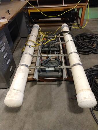
PCMSC owns and operates a portable high resolution multichannel seismic system capable of collecting sub-bottom seafloor data from a variety of vessels. The system consists of several sound sources and hydrophone receivers that can be configured for different sediment types to target subsurface structures and materials. In its smaller configuration, it can be hand deployed from small boats allowing access to shallow coastal waters. When offshore data or deeper subsurface penetration is required, the system is installed on larger ships that can supply the power, high-pressure air, and deck space needed to operate. This capability has allowed us to identify features such as submarine landslides, gas hydrates, and faults in waters of the Pacific, Atlantic, Gulf of America, and Alaska.
Sound Sources

Airgun
- (1) GI Gun (210 cu. In.)
- (2) Mini GI Gun (60 cu in.)
- 4-Gun Rack-mount Hotshot Controller
- 2-Gun Portable Hotshot Controller
- Electric Compressor – MaxAir 90 PBAC with vertical storage
- Peripherals (umbilicals, blast phones, 2-gun hanger, air handling manifold)
Sparkers and Boomers
- SIG mini-sparker
- Delta Sparker
- Applied Acoustics AA201 Boomer Plate
- GeoPulse Boomer Plates
- Associated Power Supplies: Applied Acoustics
Acquisition
- Geometrics Geoeel Multichannel Streamer
- (3) Streamer depth control birds
- Electric winch with 500m capacity
Complementary Equipment
High resolution data is often collected in conjunction with a Chirp sub-bottom profiler.


.


Check out the PCMSC Marine Facility (MarFac) web site for more information about our field capabilities.

PCMSC Marine Facility (MarFac)

Cascadia Subduction Zone Marine Geohazards

PCMSC MarFac Field Equipment and Capabilities

Coastal and Marine Geohazards of the U.S. West Coast and Alaska

California Sand Resource Assessment Project

MarFac Dive Team

PCMSC MarFac Vessels
Description of the high-resolution multichannel seismic system at the Marine Facility (MarFac) of the USGS Pacific Coastal and Marine Science Center, for seafloor mapping
PCMSC owns and operates a portable high resolution multichannel seismic system capable of collecting sub-bottom seafloor data from a variety of vessels. The system consists of several sound sources and hydrophone receivers that can be configured for different sediment types to target subsurface structures and materials. In its smaller configuration, it can be hand deployed from small boats allowing access to shallow coastal waters. When offshore data or deeper subsurface penetration is required, the system is installed on larger ships that can supply the power, high-pressure air, and deck space needed to operate. This capability has allowed us to identify features such as submarine landslides, gas hydrates, and faults in waters of the Pacific, Atlantic, Gulf of America, and Alaska.
Sound Sources
Airgun
- (1) GI Gun (210 cu. In.)
- (2) Mini GI Gun (60 cu in.)
- 4-Gun Rack-mount Hotshot Controller
- 2-Gun Portable Hotshot Controller
- Electric Compressor – MaxAir 90 PBAC with vertical storage
- Peripherals (umbilicals, blast phones, 2-gun hanger, air handling manifold)
Sparkers and Boomers
- SIG mini-sparker
- Delta Sparker
- Applied Acoustics AA201 Boomer Plate
- GeoPulse Boomer Plates
- Associated Power Supplies: Applied Acoustics
Acquisition
- Geometrics Geoeel Multichannel Streamer
- (3) Streamer depth control birds
- Electric winch with 500m capacity
Complementary Equipment
High resolution data is often collected in conjunction with a Chirp sub-bottom profiler.
.
Check out the PCMSC Marine Facility (MarFac) web site for more information about our field capabilities.
PCMSC Marine Facility (MarFac)
Cascadia Subduction Zone Marine Geohazards
PCMSC MarFac Field Equipment and Capabilities
Coastal and Marine Geohazards of the U.S. West Coast and Alaska
California Sand Resource Assessment Project
MarFac Dive Team