
Paired Air and Water Temperature Monitoring for Next Generation Water Observing System
USGS characterizes the relationship between a stream's water temperature and the surrounding air temperature to understand the influence groundwater flow into and out of the stream has on that relationship.

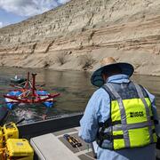
We conduct experimental monitoring to characterize the relationship between stream water temperature and air temperature, to identify groundwater inflows to and outflows from streams. This research is part of a larger Next Generation Water Observing System (NGWOS) project in the Delaware River Basin aiming to develop methods to provide high-fidelity, real-time data on the quantity and quality of water in the basin.
One-inch wide by 1.5-inch long stream temperature loggers were deployed in Little Lehigh Creek and White Clay Creek watersheds in Lehigh and Chester Counties, respectively, Pennsylvania. At a subset of stream monitoring locations, paired air temperature loggers were installed. There are about 75 loggers in each watershed that have been continuously measuring stream and air temperatures since the summer of 2021, and will operate through the summer of 2022.
The comparison of stream temperature to the surrounding air temperature helps understand the influence of groundwater inflow to and outflow from the stream at that specific location, and potentially at larger scales. Groundwater inflows in the summer may cool the stream, for example, and this would affect the correlation between air and stream temperatures. We are also using thermal cameras to identify temperature differences in a stream that can identify locations of groundwater inflow.


*Any use of trade, firm, or product names is for descriptive purposes only and does not imply endorsement by the U.S. Government.

Next Generation Water Observing System: Delaware River Basin
Pennsylvania and the Delaware River Basin

Chester County, Pennsylvania

Thermal Imaging Cameras for Studying Groundwater/Surface-Water Exchange
Geophysics for USGS Groundwater/Surface Water Exchange Studies

Groundwater/Surface Water Interaction near Ellerbe Creek, Durham, NC
USGS characterizes the relationship between a stream's water temperature and the surrounding air temperature to understand the influence groundwater flow into and out of the stream has on that relationship.
We conduct experimental monitoring to characterize the relationship between stream water temperature and air temperature, to identify groundwater inflows to and outflows from streams. This research is part of a larger Next Generation Water Observing System (NGWOS) project in the Delaware River Basin aiming to develop methods to provide high-fidelity, real-time data on the quantity and quality of water in the basin.
One-inch wide by 1.5-inch long stream temperature loggers were deployed in Little Lehigh Creek and White Clay Creek watersheds in Lehigh and Chester Counties, respectively, Pennsylvania. At a subset of stream monitoring locations, paired air temperature loggers were installed. There are about 75 loggers in each watershed that have been continuously measuring stream and air temperatures since the summer of 2021, and will operate through the summer of 2022.
The comparison of stream temperature to the surrounding air temperature helps understand the influence of groundwater inflow to and outflow from the stream at that specific location, and potentially at larger scales. Groundwater inflows in the summer may cool the stream, for example, and this would affect the correlation between air and stream temperatures. We are also using thermal cameras to identify temperature differences in a stream that can identify locations of groundwater inflow.
*Any use of trade, firm, or product names is for descriptive purposes only and does not imply endorsement by the U.S. Government.
Next Generation Water Observing System: Delaware River Basin
Pennsylvania and the Delaware River Basin
Chester County, Pennsylvania
Thermal Imaging Cameras for Studying Groundwater/Surface-Water Exchange
Geophysics for USGS Groundwater/Surface Water Exchange Studies