
Thermal Imaging Cameras for Studying Groundwater/Surface-Water Exchange
USGS scientists are using high-resolution handheld and airborne thermal imaging cameras in groundwater/surface-water exchange studies and other investigations where surface temperature contrasts indicate various hydrological processes. These cameras are used to quickly locate and characterize thermal (temperature) anomalies along streams, lakes, wetlands, estuaries, and across the landscape. Variations in temperature can be used to track the heat carried by flowing water, such as groundwater discharge into a stream, pinpointing zones of water exchange and water mixing for further analysis.
Overview

USGS scientists are using thermal infrared cameras to image the surface of water features and adjacent structures (e.g., banks, bars, seeps, etc.) to quickly locate and characterize thermal (temperature) anomalies in real-time at scales ranging from centimeters to kilometers. Thermal infrared cameras capture images of the surface temperature of targets in their field of view. High-resolution thermal imaging cameras are useful for locating focused groundwater discharge to the land surface and surface water. These sensors can be used in support of other studies where water thermal signatures are of interest, such as stream confluence mixing and evaluation of thermal refugia. Among a wide range of hydrologic applications, thermal infrared data can be used to:
- pinpoint locations of groundwater discharge and infer high versus lower discharge rates,
- map river surface thermal profiles,
- assess water mixing zones and discrete cold water aquatic habitats, and
- optimize selection of direct sampling and monitoring locations.
Although thermal imaging for water-resources studies is common using satellite or traditional crewed aircraft, the availability and wider integration of robust, small, high-resolution thermal imaging tools in support of USGS groundwater studies is more recent. Currently USGS hydrologists are deploying thermal infrared cameras locally in multiple ways, including:
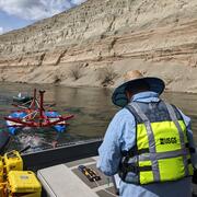
- By hand: The small size of handheld cameras makes them convenient and efficient tools for studies in locations ranging from dense urban settings to remote field sites.
- On fixed mounts: Cameras installed at streamgages and bridges enable continuous thermal imaging for real-time monitoring to inform our understanding of changing site conditions at daily to seasonal scales.
- From small drones: Low-altitude thermal infrared data collected by small drones (small unoccupied/uncrewed aircraft systems, or sUAS) enables continuous and repeatable spatial characterization of water-surface temperature at the project scale. Drones can enable data collection at locations that might otherwise be unsafe or difficult to reach and (or) that have strong water-surface thermal infrared reflection.
Additional interdisciplinary applications are being explored by the USGS Water Resources Mission Area and across USGS.

Learn More: Heat as a Tracer of Water Movement and Exchange at the Land Surface
Current USGS use of thermal infrared cameras builds on a long history of USGS research on using water temperature to help understand the movement of and exchange of water at the land surface. Temperature is a fundamental water-quality parameter, impacting chemical reaction, gas solubility, microbial reactivity, and aquatic animal metabolic rates. Water temperature anomalies and contrasts throughout aquatic systems can also be used to trace physical hydrologic processes, such as inflows of groundwater and tributaries. Figures below show how thermal infrared imaging can be used to rapidly identify, visualize, and quantify differences in water temperature that may indicate groundwater discharging to the surface of a streambank and seeping to the adjacent stream channel. To learn more about use of heat as a tracer, refer to "Heat as a tool for studying the movement of ground water near streams" and the research papers linked on the Related Publications tab of this page.


The USGS has trained scientists, provided equipment, and sponsored handheld thermal imaging camera technology demonstration and evaluation projects. A few examples of applications and related research are included below.
Geophysics for USGS Groundwater/Surface Water Exchange Studies

Thermal Imaging Camera Use: Identifying Groundwater Inputs to a Reef in American Samoa
USGS scientists are using high-resolution handheld and airborne thermal imaging cameras in groundwater/surface-water exchange studies and other investigations where surface temperature contrasts indicate various hydrological processes. These cameras are used to quickly locate and characterize thermal (temperature) anomalies along streams, lakes, wetlands, estuaries, and across the landscape. Variations in temperature can be used to track the heat carried by flowing water, such as groundwater discharge into a stream, pinpointing zones of water exchange and water mixing for further analysis.
Overview
USGS scientists are using thermal infrared cameras to image the surface of water features and adjacent structures (e.g., banks, bars, seeps, etc.) to quickly locate and characterize thermal (temperature) anomalies in real-time at scales ranging from centimeters to kilometers. Thermal infrared cameras capture images of the surface temperature of targets in their field of view. High-resolution thermal imaging cameras are useful for locating focused groundwater discharge to the land surface and surface water. These sensors can be used in support of other studies where water thermal signatures are of interest, such as stream confluence mixing and evaluation of thermal refugia. Among a wide range of hydrologic applications, thermal infrared data can be used to:
- pinpoint locations of groundwater discharge and infer high versus lower discharge rates,
- map river surface thermal profiles,
- assess water mixing zones and discrete cold water aquatic habitats, and
- optimize selection of direct sampling and monitoring locations.
Although thermal imaging for water-resources studies is common using satellite or traditional crewed aircraft, the availability and wider integration of robust, small, high-resolution thermal imaging tools in support of USGS groundwater studies is more recent. Currently USGS hydrologists are deploying thermal infrared cameras locally in multiple ways, including:
- By hand: The small size of handheld cameras makes them convenient and efficient tools for studies in locations ranging from dense urban settings to remote field sites.
- On fixed mounts: Cameras installed at streamgages and bridges enable continuous thermal imaging for real-time monitoring to inform our understanding of changing site conditions at daily to seasonal scales.
- From small drones: Low-altitude thermal infrared data collected by small drones (small unoccupied/uncrewed aircraft systems, or sUAS) enables continuous and repeatable spatial characterization of water-surface temperature at the project scale. Drones can enable data collection at locations that might otherwise be unsafe or difficult to reach and (or) that have strong water-surface thermal infrared reflection.
Additional interdisciplinary applications are being explored by the USGS Water Resources Mission Area and across USGS.
Learn More: Heat as a Tracer of Water Movement and Exchange at the Land Surface
Current USGS use of thermal infrared cameras builds on a long history of USGS research on using water temperature to help understand the movement of and exchange of water at the land surface. Temperature is a fundamental water-quality parameter, impacting chemical reaction, gas solubility, microbial reactivity, and aquatic animal metabolic rates. Water temperature anomalies and contrasts throughout aquatic systems can also be used to trace physical hydrologic processes, such as inflows of groundwater and tributaries. Figures below show how thermal infrared imaging can be used to rapidly identify, visualize, and quantify differences in water temperature that may indicate groundwater discharging to the surface of a streambank and seeping to the adjacent stream channel. To learn more about use of heat as a tracer, refer to "Heat as a tool for studying the movement of ground water near streams" and the research papers linked on the Related Publications tab of this page.
The USGS has trained scientists, provided equipment, and sponsored handheld thermal imaging camera technology demonstration and evaluation projects. A few examples of applications and related research are included below.
Geophysics for USGS Groundwater/Surface Water Exchange Studies