Stormwater facilities in Clarksburg, Maryland after a rain event
Stormwater facilities in Clarksburg, Maryland after a rain eventPhotograph of stormwater facilities in Clarksburg, Maryland after a rain event.

Official websites use .gov
A .gov website belongs to an official government organization in the United States.
Secure .gov websites use HTTPS
A lock () or https:// means you’ve safely connected to the .gov website. Share sensitive information only on official, secure websites.
South Atlantic Water Science Center Image Files

Photograph of stormwater facilities in Clarksburg, Maryland after a rain event.
Photograph of stormwater facilities in Clarksburg, Maryland after a rain event.

Changes in benthic macroinvertebrate index of biotic integrity scores at the study sites. Low scores indicate poor biotic integrity.
Changes in benthic macroinvertebrate index of biotic integrity scores at the study sites. Low scores indicate poor biotic integrity.

Photograph of sand filter and dry detention pond located in Clarksburg, Maryland
Photograph of sand filter and dry detention pond located in Clarksburg, Maryland

A USGS scientist wearing black gloves is collecting a sample of tap water from the kitchen sink using small plastic vials to test for PFAS.
A USGS scientist wearing black gloves is collecting a sample of tap water from the kitchen sink using small plastic vials to test for PFAS.

Figure 3. An EPA employee checking out an existing monitoring well in a downgradient area of the groundwater plume, Woolfolk Chemical Works Site, Fort Valley, Georgia.
Figure 3. An EPA employee checking out an existing monitoring well in a downgradient area of the groundwater plume, Woolfolk Chemical Works Site, Fort Valley, Georgia.

Throughout the historically active 2020 Atlantic Hurricane Season,USGS hydrologists have been working quickly to collect vital flood and streamflow information in impacted areas.
Throughout the historically active 2020 Atlantic Hurricane Season,USGS hydrologists have been working quickly to collect vital flood and streamflow information in impacted areas.

This USGS storm tide sensor was installed August 1 in North Myrtle Beach, South Carolina to measure the coastal impacts of Hurricane Isaias. Photo by Joshua Lee, USGS.
This USGS storm tide sensor was installed August 1 in North Myrtle Beach, South Carolina to measure the coastal impacts of Hurricane Isaias. Photo by Joshua Lee, USGS.

This rapid deployment gauge was installed August 1 in Swansboro, North Carolina on the White Oak River to monitor water levels in order track potential flooding caused by Tropical Storm Isaias. Photo by Bryce McClenney, USGS.
This rapid deployment gauge was installed August 1 in Swansboro, North Carolina on the White Oak River to monitor water levels in order track potential flooding caused by Tropical Storm Isaias. Photo by Bryce McClenney, USGS.

Sean Egen, hydrologic technician, installs a storm tide sensor
at River Dunes Marina in Pamlico County, NC
Sean Egen, hydrologic technician, installs a storm tide sensor
at River Dunes Marina in Pamlico County, NC

Cristal Younker of the SAWSC drives a boat to site 02226160, Altamaha River at Everett City, Georgia, to collect samples for the National Water Quality Program (NWQP) trends sampling. The NWQP provides an understanding of water-quality conditions; whether conditions are getting better or worse over time; and how natural features and human activities affect thos
Cristal Younker of the SAWSC drives a boat to site 02226160, Altamaha River at Everett City, Georgia, to collect samples for the National Water Quality Program (NWQP) trends sampling. The NWQP provides an understanding of water-quality conditions; whether conditions are getting better or worse over time; and how natural features and human activities affect thos

Kelsey Simmons and Kaamilya Najeeullah of the SAWSC prepare a sample from site 02336240 S.F Peachtree Creek Johnson Rd, near Atlanta, GA. The sample is part of routine water-quality monitoring for water-shed protection in Dekalb County, GA.
Kelsey Simmons and Kaamilya Najeeullah of the SAWSC prepare a sample from site 02336240 S.F Peachtree Creek Johnson Rd, near Atlanta, GA. The sample is part of routine water-quality monitoring for water-shed protection in Dekalb County, GA.

Anna McKee of the SAWSC, Norcross, GA, prepares DNA from water samples to test for bacteria that indicate sources of fecal contamination. Understanding the sources of contamination can help target mitigation and outreach efforts.
Anna McKee of the SAWSC, Norcross, GA, prepares DNA from water samples to test for bacteria that indicate sources of fecal contamination. Understanding the sources of contamination can help target mitigation and outreach efforts.

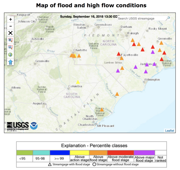
This flood event viewer map, dated Oct. 3, 2018, shows the extent and type of information collected by USGS hydrologists in North and South Carolina in the wake of historic flooding brought on by Hurricane Florence.
This flood event viewer map, dated Oct. 3, 2018, shows the extent and type of information collected by USGS hydrologists in North and South Carolina in the wake of historic flooding brought on by Hurricane Florence.

USGS hydrographer Daniel McCay uses a level to double-check a high water mark on a church door near Maxton, NC as his USGS colleague Mary Winsor observes on Sept. 25, 2018, in the wake of flooding brought on by Hurricane Florence.
USGS hydrographer Daniel McCay uses a level to double-check a high water mark on a church door near Maxton, NC as his USGS colleague Mary Winsor observes on Sept. 25, 2018, in the wake of flooding brought on by Hurricane Florence.

USGS hydrologic technician Rob Forde flags a high water mark above the eaves at Presbyterian Church of the Covenant, 118 Manchester Road, Spring Hill, North Carolina on Sept. 21, 2018, in the wake of flooding brought on by Hurricane Florence.
USGS hydrologic technician Rob Forde flags a high water mark above the eaves at Presbyterian Church of the Covenant, 118 Manchester Road, Spring Hill, North Carolina on Sept. 21, 2018, in the wake of flooding brought on by Hurricane Florence.

USGS hydrographer Kyle Marchman measures a high water mark on the rear wall of a Kangaroo gas station on Highway 24 north of Fayetteville, NC on Sept. 18, 2018, after flooding caused by Hurricane Florence.
USGS hydrographer Kyle Marchman measures a high water mark on the rear wall of a Kangaroo gas station on Highway 24 north of Fayetteville, NC on Sept. 18, 2018, after flooding caused by Hurricane Florence.

James Stonecypher measures flood waters from the Lumber River that breached a dam in Lumberton, North Carolina after the passage of Hurricane Florence, Sept. 17, 2018.
James Stonecypher measures flood waters from the Lumber River that breached a dam in Lumberton, North Carolina after the passage of Hurricane Florence, Sept. 17, 2018.

David Stillwell, USGS hydrologic technician, performs a discharge measurement to help document and forecast flooding caused by Hurricane Florence at Long Creek in Rhyne, North Carolina on Sept. 16.
David Stillwell, USGS hydrologic technician, performs a discharge measurement to help document and forecast flooding caused by Hurricane Florence at Long Creek in Rhyne, North Carolina on Sept. 16.
A WaterWatch web map shows streamgages in North and South Carolina that approached or exceeded major flood stage EST on September 19, 2018, as the former Hurricane Florence, now downgraded to a tropical depression, deluged the states with rain.
A WaterWatch web map shows streamgages in North and South Carolina that approached or exceeded major flood stage EST on September 19, 2018, as the former Hurricane Florence, now downgraded to a tropical depression, deluged the states with rain.

A USGS storm-tide sensor, deployed in advance of Hurricane Florence's landfall. The sensors are housed in vented steel pipes a few inches wide and about a foot long. They are being installed on bridges, piers, and other structures that have a good chance of surviving the storm.
A USGS storm-tide sensor, deployed in advance of Hurricane Florence's landfall. The sensors are housed in vented steel pipes a few inches wide and about a foot long. They are being installed on bridges, piers, and other structures that have a good chance of surviving the storm.

A USGS hydrologic scientist installs a storm-tide sensor near the North Carolina coast as Hurricane Florence approaches.
A USGS hydrologic scientist installs a storm-tide sensor near the North Carolina coast as Hurricane Florence approaches.